Showing posts sorted by relevance for query zigzag. Sort by date Show all posts

Friday, May 13, 2022

The Zigzag "Stone Wall" Dissenter (Nonnewaug CT)


    Here in Nonnewaug, it is my observation that many culturally stacked or laid zigzag rows of stones "snaking across the landscape" falsify Eric Sloane’s statement that:

   “One of the minor mysteries of old fences is the zigzag stone fence. Why would anyone place stones in such a fashion? The answer is simple: the stones were thrown there during a clearing, piled against an existing snake-rail fence. The rails rotted and disappeared, but the stones remained, winding across the land in the same crazy manner.”


      Here in Nonnewaug, field checking includes observations of triangular flat topped rattlesnake head-like boulders, similar to those of linear snake effigies, occurring at certain points of the zigzag rows of stones. 

Here in Nonnewaug many zigzag row of stones turn to linear rows, in some cases still retaining a boulder or stacked stone snake head.


     Here in Nonnewaug, the statement and the image used by the Gages in “How to Identify and Distinguish Native American Ceremonial Stone Structures from Historic Farm Structures”  that “If you find a zigzag wall that has even in/outs then you have a farm wall” are also falsified by observations of a large number of consistently  “even” ten foot/three meter long segments of stones creating these zigzags. The 1934 aerial photograph that includes the site of the Nonnewaug Wigwams  is a striking image of these often carefully constructed “even” zigzag stone constructions. It’s possible that some of these zigzags have wooden fence rails placed on top of them in the 1934 photograph, making some of them very visible. Field checking also reveals evidence of a number of decomposing chestnut rails on top of these zigzag rows of stones.
          If a zigzag stone fence is composed of random stones plucked from a plowed field that have been tossed against wooden rails, then would this indeed have the more “regular” and “even” appearance as opposed to stones intentionally “serpent stacked,” recalling these powerful and protective Spirit Beings?


  Here in Nonnewaug, I interpret the majority of these zigzag stone constructions to be Indigenous Great Snakes rather than the later “messy” field clearing debris of the post-contact period. I would suggest that the addition of wooden rails was to meet legal property ownership requirements under colonial law, “improvements” to otherwise “vacant land.”


  And yes, of course, here at Nonnewaug, a few other statements are drawn into question:

Gages “Farm Wall Criteria”

‘A sketch map or aerial photo shows an organized layout of fields.’

(Implies Indigenous Peoples were “unorganized,” implies enclosures were unrelated to Indigenous Landscape usage rather than later cultural appropriations.)


   ‘There are openings in the wall to allow access to the fields.’


   (Serpent Gateways at openings, guardian spirits of whatever was inside the enclosure – sometimes wide, sometimes narrow. Sometimes a “step/stone turtle shell” in an otherwise continuous fuelbreak.


 May have a stone wall lined "road" leading to the fields called a cow lane or cow path.

(Remnants of zigzag and linear rows of stones, exhibiting Indigenous Iconography,  still line both sides of many roads, including Nonnewaug Road, evidenced as well in the aerial photography of 1934 before many of the roads were paved and widened.)


May have a wall with multiple notched stones evenly spaced out (about 6 ft apart).

(Many may be Horns possibly placed behind/above snakeheads in the uppermost course of stones, “serpent stacked” smaller effigies that are part of a larger Horned Serpent or Great Snake effigy. These stones may also be horned medicine people or spirit effigies, some of which may also be "about to sing." )


Curtiss Hoffman

I strongly disagree with my friend Curtiss Hoffman when he writes (in part, in "Stone Prayers," page 61): "As Allport and Thorson have shown, New England colonial farmers built thousands of miles of stone walls to separate fields, either to control movements of livestock, or as property boundaries. However these walls are generally made of well-laid stones and are higher than one course of stones, and they also run straight in one direction, and meet at right angles, and tend to be continuous for considerable distances, wherever they are not dilapidated or punctured for cart paths. What I am calling "stone rows" lack some or all of these features: they tend to be made of smaller stones which are more haphazardly laid; they may be only one or two courses high, so they would not be able to function to keep animals in or out...they meet other walls at non-right angles..."

   (Allport and Thorson (et al) are repeating a colonial myth related to “Yankee Exceptionalism” that completely ignores the idea that Indigenous Peoples of the Northeast built with stone. Many “walls” featuring Indigenous Iconography, both zigzag and linear, are “well laid” and “higher than one course of stone,” and in my experience do extend for “great distances” and do meet at “right angles.”

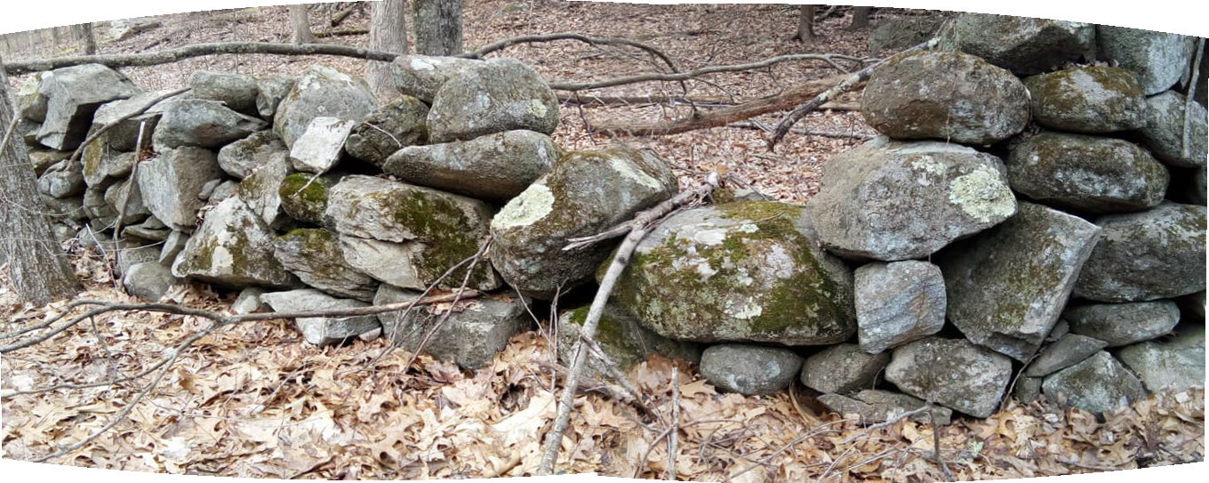
“Haphazardly” is hardly the term for some of the more massive and exceptionally well built stacked stone constructions that have managed to survive unmaintained over hundreds of years of time.  


    Before 1990, I might have told you the same old story about the mystery of zigzag stone walls that almost everyone still repeats, derived from the writer and artist Eric Sloane. Since 1990, when I began “ground checking” what should be “Yankee Farmer built stone walls,” I became more inclined to suspect that the oldest of the stonework was made by Indigenous Peoples over an undetermined number of years. And I can’t find one yet, a zigzag stone wall that fits the Eric Sloane conjecture turned fact method of construction, although in a small number of places, the angle segments are filled with what appear to be dumped field stones from later field clearing of plowed enclosures for a short span of distance. I have also come across one example of old chestnut rails placed on top of a series of single stones.
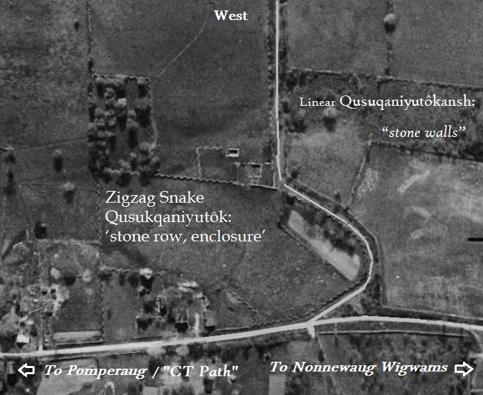
 

    My little Case Study of “Zigzag Stone Walls” mostly comes from around where I live, an English Watch House overlooking the former floodplain fields associated with a late Woodland/Contact Era Pootatuck village known as The Nonnewaug Wigwams, occupied in 1672 when colonists fron Stratford CT arrived, and “abandoned” sometime around 1740. The Indigenous place name probably refers to the stonewall-like diagonal fish weir in the river of the same name. And yes it’s the “Nonewaug” Cluster in “Stone Prayers” by Curtiss Hoffman, a place where I do vaguely give out locations by saying “in plain sight most everywhere one goes.” My experience 
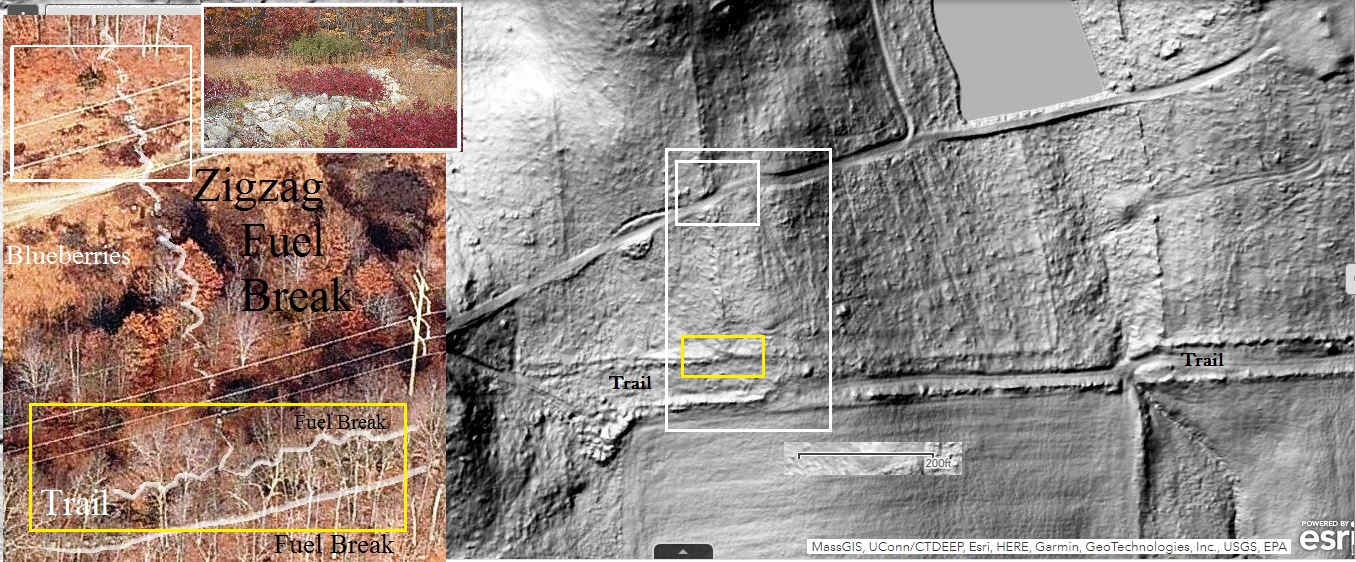
and observations are that the oldest and most numerous of “stone walls” are probable snake effigies that served in part as fuel breaks and water control on a Sacred Landscape that was in part a garden and in part similar to a great and vast cathedral.


An incredibly beautiful example:

https://wakinguponturtleisland.blogspot.com/2017/04/grey-fox-serpent.html

 Way too many more examples:

 https://wakinguponturtleisland.blogspot.com/search?q=zigzag

At Rock Piles over the years: 

https://rockpiles.blogspot.com/search?q=zigzag

Tuesday, July 17, 2012

Back to Zigzag 2012


Aerial survey of Connecticut 1934


Twenty years or so later, it always seems to come back to those Zigzag Stone Rows. Of course if you count the very first stone row I wondered about, thinking why someone made an incredible number of “stone walls” in a lightning bolt shape, it would be between forty or fifty years ago.


Eric Sloane was the first source I ever came across that made a simple explanation of Zigzag stone “walls” in New England. He tells us that they were sort of accidently made stone fences, composed of stones from field clearing that were thrown at the base of a wooden “Snake Fence” or “Worm Fence,” a post less early wooden rail fence that was easily constructed. Sloane wrote about that in the 1950’s and everyone who has ever written a stone wall book or is considered an authority on such matters repeats that explanation.

I’ve been looking for a long, long time now for at least one zigzag stone row that fits this description. I haven’t found it yet. It’s something I’ve never seen.


I’ve found a few places where the old rails still sit on stones:


I’ve looked for evidence in old paintings in hope of finding at least one zigzag stone row that fits the standard myth about these “walls.”


The only thing that even comes close is the “piling of field clearing stones up against the already carefully made zigzag stone row.”


I was reading about prescribed burns the other day when I came across a “How to Guide” sort of thing that mentioned establishing a firebreak that’s at least eight feet wide. Then I thought about all the roads I drive along that are bounded by what we’ve been brought up to think of as those famous New England Stone Walls as I commute to work. It struck me then that these roads, some former Indian Trails still called by their Native American names, would make pretty good fire breaks.

Dry Land Double Stone Rows

Many of the water features you can see in the old photo show that they too are sometimes bounded by double stone rows. Over the past 20 years, I’ve found that almost all the smaller water features that you can’t easily see are, more often than not, bounded in stone, more often than not zigzag rows. These would make good fire breaks as well – and as a bonus there would still be a green living canopy shading the water, a resource riparian zone that was perhaps burned on a different schedule.

These zigzag stone rows are said to be rare:

A video of one such zigzag stone row:

I contend that the famous stone walls of New England (and beyond) are older than they are thought to be, their colonial and later origin a myth rather than the truth:


Wednesday, June 27, 2007

The 100-Year Flood


The 100-year Flood:
It was a heavy localized thunderstorm. The old timers said it was worse than the “Flood of ’55.”

I’d been working on the drainage problems on the backside of my house. I’d made a zigzag trench about ten feet from my back door, on the other side of the original well. I had a serpentine sort of swale along my flower gardens above that. Water would pour down from the highway above my house, down the upper driveway by the highway, then through the yard, and into my basement during storms (or ice melt) and I was trying to fix that. The 100-year flood storm, flowing into those depressions, actually removed soil in the center of the channel, the shape sort of forcing all the power to the middle rather than the sides.
I remember going out the backdoor to remove some debris in the zigzag and getting poked in the eye by the stalk of a plant but still being amazed that the channel was being dug out by water power for me - instead of by shovel and “me power.”
Totally soaked in seconds, I went from back door to side door to stand on the porch to watch the water flow down the side of the house and down my lower driveway to the street – it was like a good sized brook flowing through the yard. I could hear the thunder up in Bethlehem to the north where the center of the storm cell was.
The storm moved off, but in a short time I heard the strangest kind of roaring in the distance. Since it sounded like it was coming from upstream on the river, I went to my front door where I had a clearer view of the river; I can see one of the weirs the water company maintains to fill a reservoir from there across a field on the other side of the road.
The roar got louder as a wall of brown water suddenly appeared on the distant river. In minutes the floodplain turned from fields to a lake about a half-mile wide. On my side of the floodplain, the water at it’s highest flowed along what appears to be an ancient glacial lakeshore. Near the linear row that I’ve been writing about with this road re-alignment, at the low end of it, the water washed clear a row of boulders, possibly natural, perhaps not.

Somewhere I’ve got some video footage of the flooding that day and a few days after as well.

I’ve written about a stream that flows around the Burial Grounds. This big flood cleared a lot of the ancient zigzag above the first terrace “island” that is the Burial Grounds - and the serpentine rows at the low end. The branch that had been diverted to flow to the field and the river got blocked by trees, filled in with rocks and dirt. It moved back to its original location, the lower or western edge of the Burial Grounds. The serpentine row of stones on the edge of the BG was washed clear of leaves and debris, as well as a second row on the field side of this stream, a row I didn’t realize even existed.
At various places down stream, I could see remnants of the stone rows that once bordered both sides of the riparian zone of this stream, along the edge of what I think of as the “Village.” All my suspected habitation sites stayed above water.

There were many other places that the rows minimized flooding. Along one of the largest tributaries, zigzag rows on both banks of the river prevented flooding, but at a bridge that disturbed the rows and their function, the water washed away the bridge and scoured out the river almost 20 feet deep, taking away the zigzag rows downstream of the former bridge for hundreds of feet. I regret that I never took photos of those rows before the flood, back in the days before I had a digital camera. The same construction company that is working in front of my house as I write rebuilt the bridge - also destroyed those zigzag rows above the bridge site in the process, used the stone in their rebuilding efforts. I should walk up in there to see what remains upstream…

So there is a ‘hydraulic” (spell check prompts me to spell, even though I wanted to write “hydrolic”) or water management aspect to the stone rows too (Mavor and Dix mention this in “Manitou, I believe, spelling it “Hydrology”).

A drought followed the flood. I could walk streambeds and see that as the flood subsided it formed a sort of natural zigzag pattern of stones in some places. I also went up to a beaver dam that I know of, that I found by following zigzag rows, to find the flood had knocked it out – and the rows below it for quite a distance. The beavers began rebuilding it very quickly – by building a series of zigzag walls of sticks, sod, mud, and stones up from the streambed. This may be a glimpse into a similar observation made by Indigenous Peoples in the past, a bit of Traditional Ecological Knowledge inspired by the "Helping Beaver," who also participates in many versions of the Turtle Island Creation Story.


So the 100-year flood taught me a thing or two about zigzag rows. The natural processes of flooding (and beavers) could have inspired the Native American building of zigzag rows. The rows could focus the power of the water to the center of the streams, keeping them fairly clear and “in place,” protecting burials and habitation sites. A scheduled occasional burn could selectively be used to manage the land inside and outside the borders of the stone rows.

And I should add that shortly after, while making a antique furniture house call in North Salem NY, very near the famous perched boulder, I took a lunch break along the little river that flows by that big stone, just a little south of it. I sat on a zigzag row of stones on one bank, looking across the water at another zigzag row on the other bank…


The photo above is not mine but is from an interesting article: http://pubs.usgs.gov/of/2004/1062/5_neely.pdf

Tuesday, April 10, 2012

One Thing I’ve Never Seen


I’ve never seen a zigzag stone fence that shows any evidence that it was formed by the random and gradual haphazard tossing of stones up against a wooden “Worm Fence” or “Virginia Rail Fence” or any other name you might find to call a post-less “fence, zigzag in plan, made of rails resting across one another at an angle,” as Mr. Dictionary.com puts it, that has rotted away, leaving only stones that recall these at one time very common constructions. Come to think of it, I’ve never seen a photograph of a single zigzag “stone wall” that met that description.

The only representations of these types of “stone walls” that I have ever seen are drawings, all of them much like Eric Sloane’s above.

Here’s an actual photo, from sometime before 1866 when a friend’s relative began a scrap book, of a local wooden zigzag fence that someone apparently forgot to pile (or throw) rocks up against:

The builder did stick a couple stones at one visible point of the zigzag, but somehow neglected to throw the mandatory stones from both field clearing and cart path or possibly road building up against the rails rather than place them under the fence. The builder had no idea that the great era of stone fence building, 1750 to 1850 had actually passed by, just before barbed wire was to become readily available too.

Of course there is that 1871 Department of Agriculture Survey that in all 39 of the United States, sixty percent of all fences were wooden zigzag rail fences

My opening statement might be questioned somewhat if you were to take a look at a 1934 aerial photograph of where I live (Aerial survey of Connecticut 1934 photograph 07599), at the time small tractors were beginning to be sold to the general public. You might notice, as you zoom in for a closer look, that the photo shows numerous zigzag rows bordering roads and dividing fields. – even more so if you walked below the canopy of trees that covers many streams and swamps and actually saw all those zigzag stone rows that form borders around those water features or that are partially buried below leaves or a cover of vegetation and hard to see. There are a lot more of them visible on the ground, sometimes partially buried by 350 years of field clearing and road widening.

You might even point out to me that there is more than one of these zigzag rows in my own yard. I’d have to point out to you that these are carefully constructed rows of stone, more often than not large boulders at the points where these ten foot long segments “zig” and then “zag.”


You might even notice that a little north and east of my house there is a perhaps 800 foot long zigzag row on the border of fields still used by farmers today, although the southern end of it turns into a straight line.
This area of land is mentioned in a local history as the only cleared fields or interval land – floodplain fields – not put into use the first year, 1672, that people of European descent, as crop planting land. It wasn’t used because Native American people were living there at the time, growing corn that supported bean plants with a ground cover of squash (and probably pumpkins) planted in those mounds.

The little white dot at the southern end of the row is an unusual boulder that for the first time caught my eye in early 2009.

By the end of 2010, I had heard about short segments of stone rows that people were suggesting might be effigies of a serpent found in Native American stories sometimes called a “Horned  Serpent,” as well as other snake-like creatures such as the “Foot Snake,” a sort of giant inch worm creature with a large head and feet. Inspired and intrigued by this, I did some clearing and cleaning around this boulder. I wondered if it might appear to resemble a snake head:

Oh: Wooden zigzag rail fences are also sometimes called Snake Fences.


“How Fences Kept 'Good Neighbors' J. Edward Hood (1997): “In 1871, nearly half of all fencing in Massachusetts consisted of stone walls or stone walls with wooden rail tops (figure 1); 31 percent were post-and-rail figure 2); 6 percent were "worm" fence, also known as "zig-zag," "crooked," or "Virginia rail fence" (figure 3); 3 percent were post-and-board; and the remainder consisted of a variety of types, including picket and board fences typically found in front of houses. In other states these percentages were quite different: in New York, for example, worm fencing accounted for 45 percent of all fences, and in Arkansas, 98 percent of fences were of this type. In fact, zig-zag was labeled "the national fence" by the authors of the 1871 report, because it predominated in so many regions…”
http://www.osv.org/explore_learn/document_viewer.php?DocID=596

Like: Good Fences: A Pictorial History of New England's Stone Walls

By William Hubbell Contents page” A rare example of a zigzag stone wall (see page 25):

Monday, April 07, 2014

Stone Layers Along Quassapaug Trail/Road


The modern Quassapaug Road (above) got its name from the Old Indian Trail to Lake Quassapaug. The stones along the road tell a story of sorts, from the oldest remnants of the Indigenous zigzag rows of stone that bordered the ancient trail to the most modern of stones, the pile just recently imported and dumped at the end of a driveway plus all that ended up where they are in the years in between.
Where the stones are completely gone is also part of the story. There’s perhaps many places the old stones could have gone, re-used for something somewhere or maybe they are buried right there.

Or perhaps they ended up across the street on the opposite (west) side of this four corners, the road just south of Hamilton Ave. and Middle Road Turnpike. Maybe the stones were used constructing the culvert. Just a step or two away, however, there’s a small segment of stones in the zigzag pattern, not so much like thrown stones up against a wooden Snake Fence, but something stacked more carefully, often a large boulder at the points of the zigzag, sometimes effigy-like stones chosen and placed “just so:”


A retaining wall and what looks like a whole bunch of tossed or dumped field clearing stones. 

On the opposite side of the road, I can tell you a little bit of a story. The house was a project by a local Technical/Vocational School a friend of mine attended in the early 1970’s.
This was formerly a field, part of a nearby farm. The old farm house is right around the corner, now a nursery, I believe. Under all those stones, tossed on the edge of the field, there may be a buried stone construction, possibly zigzag...
Maybe the old rows of stones are buried under stones and brush and fill…
Farther down the road is much the same:
Except for one segment of zigzag projecting out from under all the newer layers:
(This segment of row appeared here before: http://rockpiles.blogspot.com/2014/01/zigzag-in-snow.html )

The opposite side of the road does show some evidence of one time having zigzag rows present:

Above: “point” stones – large boulders about ten feet apart and some remaining cobbles. Below: a single segment of zigzag stone row remains, cobbles between “point” boulders… 


Moving farther north on the opposite side of the road shows some some signs of possibly the tendency to straighten out those low zigzags rows of stones into a more "proper" New England stone wall. A break in styles, most likely shows a later attempt on the left, while on the right there are a few more possibilities. The Indigenous row may have been a linear sort of row of stones... 


Often, around here, a zigzag row of stone turns into a more linear sort of construction, just as it does further down the road, on the opposite side of the former trail:
The longer existing linear segment has a little short segment that reaches out toward the former trail at a right angle, ending in a large boulder. There’s a good sized cobble on top of that boulder:


      Perhaps that cobble is a effigy as are possibly a few more a little farther back on that little jog, and some interestingly shaped and placed stones on the longer row as well:

The above photo is surprisingly reminiscent of a detail in  a “rock wall” from a “High Place” near Mount Shasta in Northern California in an Alyssa Alexandria photo below: