Thursday, May 31, 2018

Well-defined trails to Mattatuck


     “Previous to the discovery of the beautiful meadows at the great bend of the Tunxis River...nothing was known of the territory west of the Talcott range, except as it may have been penetrated rarely by a few daring hunters and explorers. When a treaty was ratified with the Indians, in 1650, and the lands opened for settlement, two well-defined trails led westward through the woods, one practically where the first colonial road was built from Chippen's Hill to Farmington; the other southwestwards crossing the mountain, west of the sewer beds diagonally; crossing the present town of Wolcott also in a southwesterly direction; thence through the southeast corner of Plymouth to Waterville, then in the territory known as Mattatuck. Over this trail to Mattatuck the early settlers of Waterbury travelled, taking the first millstones ever used in that town on horseback. At the reservoir on South Mountain, southwest of the Allen place, near the south end of the pond, and not far from the town line, the trail crossed what was then a swamp over a causeway of loose stones and earth, the nearest approach to a roadway ever made by the aborigines. The trail crossed Mad River near the beaver dam which then existed near the south end of the Cedar Swamp reservoir, continuing southwesterly, the present highway following it for some distance...”
Bristol, Connecticut: "in the Olden Time New Cambridge", which Includes Forestville
   Page 9
City Print. Company, 1907 - Bristol (Conn.) - 711 pages


SW Trail, well defined??
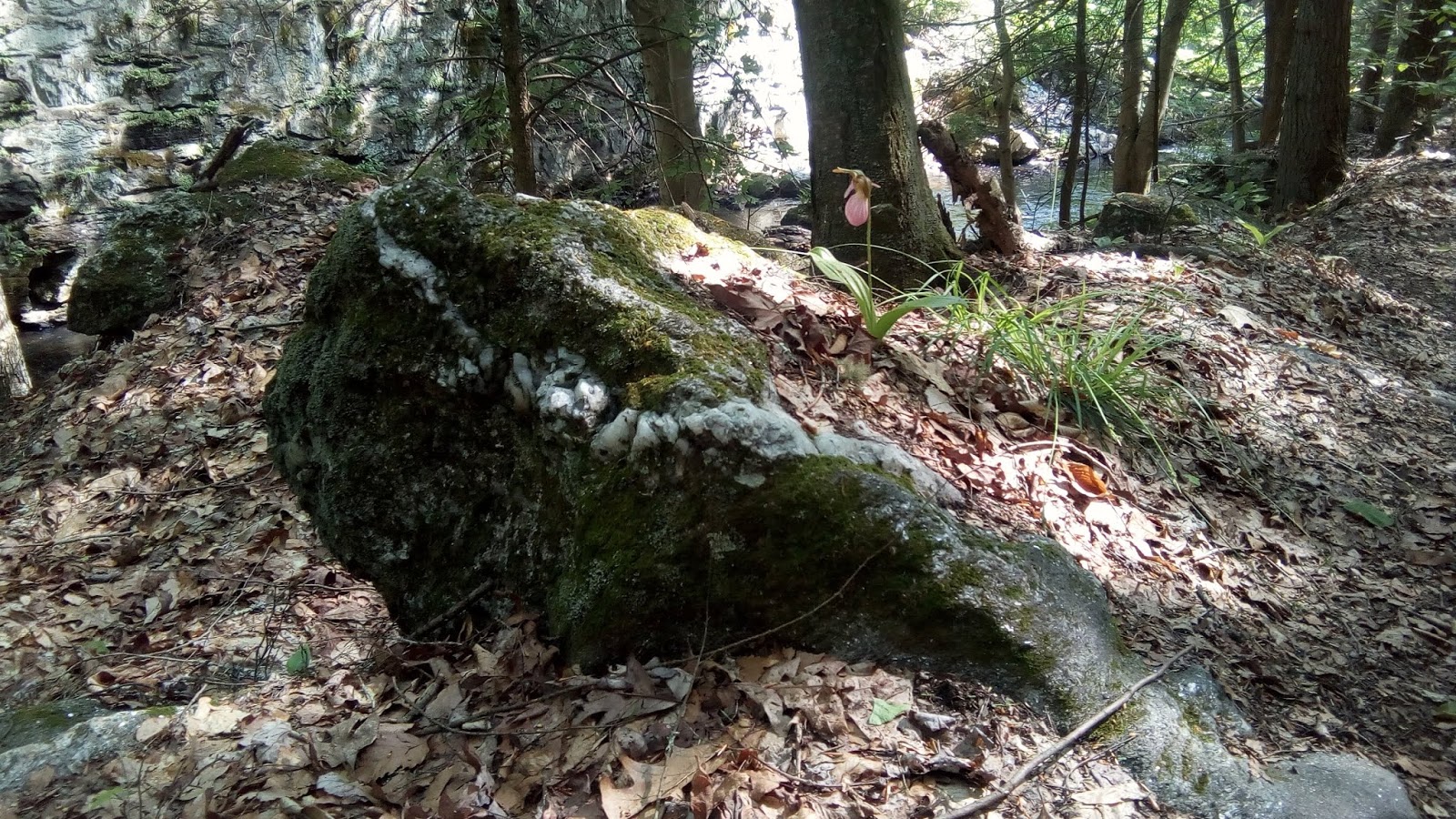
"This is a beautiful trail, and so long as you stay close to the brook, it's a relatively easy hike."

Above photo used with the kind permission of (the excellent):
 "Raechel Guest's Waterbury Thoughts Blog" 

A few original images captured of the "retaining wall" that seems to incorporate Indigenous/Native American Iconography:


A comparison to another stone lined trail in Bethlehem CT, along a brook leading to the "Indian Cave" which is possibly the remnants of a Stone Sweat Lodge/Pesuponck:


Older scanned photos circa 1997:

Before localized flooding filled in the "Plunge Pool:" 

Sunday, May 27, 2018

Another Possible Indigenous Causeway (Waterbury CT)


    My friend assured me that the trail was an easy walk along the river – well, a brook really, a tributary of the Naugatuck – and it would be much cooler by the stream. And there was some very interesting stonework to be seen on both sides of the river. I’d spent the morning driving to and from an appointment with an Infectious Disease doctor with results that left me more ready to sit around and mope but my good friend talked me into it, as if saying “Don’t give up, don’t let the disease rob you of this opportunity.”
    We travel to the end of a street I’ve never been on before, park by a quarry, pass by the powerlines where a wide swath of ground up stone is a bright new scar on the Connecticut landscape and turn onto the trail along the brook. There’s a rusted old iron bridge we pause by, and later I find that it was built in 1884 to “accommodate two lanes and exceptionally heavy loads...countless tons of product fresh from the Waterville factories began their journey to distant destinations,” linking to a railroad line that dates to 1850...
     There’s years and years of stonework on that steep bank where the railroad bed is and we marvel at it from the trail we are walking on the opposite bank and we stop a minute to descend from what I slowly realized was a sort of causeway built into that side of the riverbank. I had to get a closer look at the lowest and closest to the river stonework, noting the bright white quartz rhomboidal that admittedly does not show well in this photo: 
     I had not taken my camera (well, cellphone) out of my bag up until this point, captured a couple images before that photo above was taken (or “mistaken,” you could say). I did take one photo before that, a possible zoomorphic stone in that causeway wall, perhaps the head of a turtle and a hint that we might have been walking on an Indigenous Stone Structure of undetermined age:
Ascending back up, I got a better view of the stones I’d just carefully climbed down, resembling another turtle-like head and a boulder that looked like a shell with what resembles the nuchal notch of an actual turtle shell:

    I culled a few images of that “wall” and the trail that I found online since the low state of my battery power on my two devices severely limited my ability to take my own photos. The “little hints” that I found other people speculating about never included any mention of a possible “Indian Causeway” or even a single mention of the long presence of Indigenous People in the area.

You will find some mention in the older local histories such as Orcutt's: 
   This is a photo that Wikipedia uses that often appears on those sites about walking trails. I don’t know the trail well enough to know exactly where this is but that’s the Possible Causeway on the right:


    One of my own:

 Above: Angling around this stone, getting the darker background of a tree to highlight the Pink Moccasin in bloom, if you look across the brook you’ll see modern stonework with obviously some sort of Portland cement used for mortar on the sheer wall below the railroad bed. The band of white quartz highlighted on this triangular boulder could be said to evoke an image of a rattlesnake head, the rather round or oval shape representing an eye...


The other side:

   Fair use of the Wikipedia image includes the statement that I could alter the image seen earlier, so of course I’ll just overlay an eye of a rattlesnake that I lifted and often use:
   But you know my friend really wanted me to see what he said that even to his skeptical eye was a “big turtle.” Call it coincidence if you will but as he headed to one side to give the proper perspective of size to the photo, I walked past a large boulder of this familiar shape:
"Manitou Stone"
   I know the left side is out of focus – and the narrow neck doesn’t show well – but I’d really have to say that this is an example of some rather large features of the Sacred Indigenous Ceremonial Stone Landscape, turtle eyes overlaid onto the original composite photo:

   My friend had one more "larger boulder" he really wanted me to see:

  An interesting walk to say the least, another Flickr album with all the embarrassing bad photos of the day, surely more to be added if I ever get back up to this spot again:


Friday, May 25, 2018

Wâunonaqussukquanash: “Honoring Stones”


Is it a work station?
Was it someone’s grinding slick?
Was it someone’s grandmother’s place to make Medicine,
 In the place where the Medicine was found,
Near other grandmothers’ stones
That became Wâunonaqussukquanash - “Honoring Stones” –
When those grandmothers walked that White Path across the night sky?


Monday, May 21, 2018

My Dad's Turtle (Westbrook CT)

Morning Light
Taken on May 11, 2018
Overcast

Taken on May 6, 2018
Crop of above with overlay turtle eye
Clearing to the other side:


Taken on May 12, 2018


"Squeener's Turtle"
I've heard it said that prayers said over a stone
become part of that stone
and the prayer continues forever within that stone.
Although I didn't place this stone here this way,
This stone Grandfather Turtle will forever be filled with
Prayers for my Father
John Patrick MacSweeney...


Monday, May 07, 2018

Ceil's Stones in Early Spring (Westbrook CT)


(The Late Early Spring of 2018)

    The curtain is closing in the Late Early Spring of 2018. I’d driven down to my Mom and Dad’s along Route 9, past all those rows of stones that stretch out in the distance, stones that I’ve never walked beside but gaze at in wonder as much as bad drivers in the stream of traffic will allow. The leaves on the trees are drinking in the previous day’s rain, every cell fully formed and expanding with the water, closing the curtain...

    Slathered with tick repellant, the grandkids and I take a little walk down to the river, to the across the street neighbor Tom’s crabbing dock on the Menunketesuck River, named for the alewives, a "river herring" whose population is declining so much that the State no longer allows them to be taken – unless you scoop the landlocked version that has evolved since the numerous dams began being built in the 1600’s at certain lakes including Lakes Quassapaug, Waramaug, and even Highland Lake, all places in Pootatuck/Paugusset territory. These are those fish that, when they “ran” up the rivers to spawn, you could “cross the streams on their backs without getting your feet wet” and harvest by the barrel full in minutes back in the early days of European settlement, if you can believe all those old histories.

   The grandkids and I looked but we didn’t see a single fish of any kind, including shad who run when the shadblow or serviceberries bloom...
   I suspect an oyster bed (garden?) once existed right at this spot, perhaps when the Colonists arrived and "drove out the Pequots," as they say, but surely long before perhaps. A few long rows of stones lead to it, including this one that extends into connecting rows in the National Wildlife Refuge - where I hear someone is quite interested in Ceremonial Stone Landscapes. I wonder if this person has been reading this blog...
   But back at my parent’s house, I did get a chance to look at a row of stones that my brothers and I have been cleaning up gradually...

And extending the golf cart path as well...


 There’s a few more posts I can squeeze out of the weekend photos, as time allows...


An Alewife:

brochure (PDF) describing the closure is available.