Students of the "stone wall" like this feature on this CT LiDar Viewer, the "Swipe" option that allows the viewer to quickly switch from a Hillshade view to some autumn aerial imagery that sometimes shows distinct rows of stones sometimes - or sometimes not, as above. Toggling the swiper, one suspects that there may be rows of stones up on that scenic hilltop in my old hometown:
Sunday, September 25, 2022
LiDar Swiping
Saturday, September 24, 2022
Walking Slowly to Medicine Rock
We really didn’t go
all that far, my brother and I, but we saw some interesting things. We saw the “nearest”
Medicine Rock (one of two on the trail map), a milky white quartzite outcrop,
but we also saw a great number of dead ash trees as well as two peculiar rows
of stones that seemed sort of related to the one of the multi-trunked trees
(maybe, possibly):
We had been noting an absence of “stone walls” and finally found two. There was one that was composed of larger stones, pointed at about true north while the other is composed of smaller stones which appeared to continue in into the brushy distance to the west, sort of a bunch of stone circles rather than a linear or zigzag construction, although it appears somewhat serpentine on the LiDar image I pulled up from the world-wide computer-net:
So here’s a “Why go back?” answer: There are some interesting things to be seen on that tiny piece of the world and only the curious have something to find. I've got a snapshot of 1934 to look at, as well as other perhaps traces of older cultural stone landscape features to observe…
A Row of Káhtôquwukansh or “Stone Prayers?”
Monday, September 05, 2022
Drought and the Great Serpent
I’ve been
watching those old stone snakes transform and disappear for years now, some rebuilt
to make them “pretty” or, even worse, far too many just bulldozed out of
existence - neither of which can ever be undone. When I drive by and see some
brush clearing going on along a row of stones, I will often cross my fingers
and hope that they just leave that “stone wall” untouched, thinking I’ll be
back sometime soon to catch a good photo of some Indigenous diagnostic feature but
more often than not, the next time I drive by, I’ll find that the machines got
there first and that artwork I saw is forever gone.
The Great Serpent is
an Indigenous spirit being who, among other things, can bring rainfall. The
thought passed through my mind that perhaps this destruction of the “snake rows
of stones” and the drought just might be related…
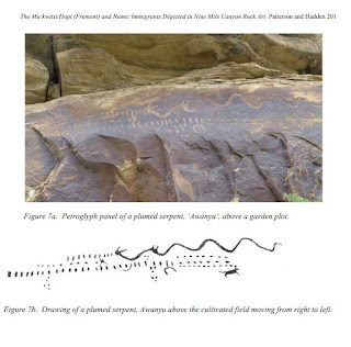
"To the Tanoan language speakers along the Rio Grande, this mythical horned and plumed serpent Awanyu appears as a flash flood, winding its way down an arroyo after a heavy rain. It is a water serpent both feared and respected. He lives in springs, ponds and rivers and when angered can cause heavy rains destroying crop fields..."
https://wakinguponturtleisland.blogspot.com/2018/08/avanyu-water-serpent.html
https://wakinguponturtleisland.blogspot.com/2016/08/look-little-closer-at-stone-wall.html
https://wakinguponturtleisland.blogspot.com/2007/06/im-listening-to-sound-of-thunder-in.html


