Monday, February 27, 2023

Look for a Gap in the Stone Wall (Weir farm National Park, CT)


Julian Alden Weir, Autumn, oil on canvas, 1906.
Gift from the Trustees of the Corcoran Gallery of Art, William A. Clark Collection.

  "Julian Alden Weir’s most successful landscape paintings of his Branchville farm all share a few of his simple truths: sun-drenched fields contain both beautiful vistas and unsightly dying trees. Common subjects are beautiful and worth examining. Weir’s paintings are filled with impediments that intentionally slow down how fast a viewer can observe the painting. The wetlands, boulders, trees, fences, and stone walls in Autumn are the visual representation of Weir’s belief that one must spend time in nature before nature reveals its beauty.

  Autumn is on view in the Weir House."


My own impression:


Another Gap in another "stone wall:"

Looking closely, one is tempted to wonder about the actual origin of this gateway: 


I would suggest that this is a fourth type of "stone wall" (the cultural landscape reports, the brochures and videos etc. all repeat that there are three types of stone walls on the parcel) that presently can be seen at Weir Farm, the sort of stone wall known as a "Snake Stone Wall," as Doug Harris says in the National Park Service training video about Indigenous Ceremonial Stone Landscapes:

Another Gap or Gateway at Another Preserve in CT:


Thrown or Tossed Stone Walls or Ceremonial Stone Landscape features??


Transforming a stone wall rather than conserving the original just might present a falsified view of the history of these stone structures that are sometimes referred to as Qusukqaniyutôkansh, the plural form of Qusukqaniyutôk: (‘stone row, enclosure’ Harris and Robinson, 2015:140, ‘fence that crosses back’ viz. qussuk, ‘stone,’ Nipmuc or quski, quskaca, ‘returning, crosses over,’ qaqi, ‘runs,’ pumiyotôk, ‘fence, wall,’ Mohegan, Mohegan Nation 2004:145, 95, 129) wall (outdoor), fence, NI – pumiyotôk plural pumiyotôkansh.) - Nohham Rolf Cachat-Schilling

Bulletin of the Massachusetts Archaeological Society, Vol. 77, No. 2 (Fall 2016)

https://vc.bridgew.edu/cgi/viewcontent.cgi?article=1202&context=bmas


Notes:

Meadows

 Truants' Meadow, located east of the Weir House and Weir Barn, served as the setting for numerous Julian Alden Weir paintings, including The Truants (ca. 1895). The meadow would also be the subject for Landscape: Branchville, the Palace Car, which depicted the outdoor painting studio a former caretaker, Paul Remy, built around 1890. Weir would use this meadow to showcase his interest in Japonisme ink drawings by creating Building and Stone Wall here. Weir purchased the meadow as part of ten acres of land east of Nod Hill Road in 1896 as part of building Weir Pond. Aerial photographs from 1941 and 1951 show the meadow remained open. The meadow still retains much its historic character.

Streams and channels
 The stone-lined water diversion system appears to have been constructed in 1896 in conjunction with the creation of Weir Pond. These channels divert runoff from an adjacent watershed into Weir Pond. The system carries water from a wetland area to the north. A stone-lined ditch runs from west to east and after approximately 250 feet, the ditch branches into a south fork heading to Weir Pond and a north fork leading around the pond. Some stones have collapsed into the ditch and certain sections are laden with debris.

Other Features
 Throughout the Pond and Woodland area, laid stone walls are present and composed of stacked, irregularly shaped fieldstones. The stone walls predate Julian Alden Weir's 1882 purchase of the property.

During the Weir and Young tenures, repeated trips from the house to the fields, pond, woodlands, and dump east of Nod Hill Road created a circulation feature known as the Wagon Road. The road, a compacted earthen route, began near the northwest corner of the Truants' Meadow, continued along the meadow's eastern edge, and entered the woodland area to the south. Sperry Andrews often painted the landscape looking northwest from the Wagon Road around the marshes.The Wagon Road is presently in good condition with the park maintaining an approximate ten-foot wide swath along the historic roadbed free of woody vegetation.


The original path to the pond including crossing a fishing bridge, seen in Julian Alden Weir's The Fishing Party (ca. 1915) and his earlier painting, Return of the Fishing Party (1906). While Mahonri Young's son, Bill Young, helped repair the bridge; it would eventually collapse. When the National Park Service acquired the property, only fragments remained.


Today

The National Park Service built a bridge, which runs parallel to the historic fishing bridge. This bridges leads to a yellow-blazed trail that takes visitors to Weir Pond. An Eagle Scout service project created an additional foot bridge that brings visitors over a stream-bed.

https://www.nps.gov/wefa/learn/historyculture/places-woodlandarea.htm

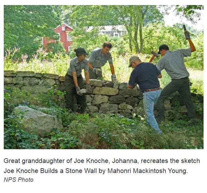
“Stone walls are objects of mystery and fascination. Remnants of an agricultural existence that once dominated this landscape, these walls linger as the last relics of an all but vanished past. They trace fields now fallow and line roads now busy and paved, but still hint at a time when artists and farmers walked the grounds together. These walls divided property and kept animals contained, but also inspired many enduring works of art. They are both functional and beautiful. Created by craftsmen and laborers, these walls are as much art as the paintings that they inspired. They are simple and complex; stoic and elegant; both ancient and modern at once…”

http://npshistory.com/brochures/wefa/stone-walls.pdf

• Restoration of Weir Complex landscape to reflect conditions extant circa 1940.

• Rehabilitation of Burlingham Complex landscape to retain changes Cora Weir Burlingham made after 1940.

• Restoration of Pond and Woodland Area landscape to reestablish select farm fields and other missing features that existed circa 1940.

http://npshistory.com/publications/wefa/cli-weir-farm.pdf

Sunday, February 26, 2023

More "Stone Wall" Dissent (Weir Farm Nat. Park, CT)

“Evaluations of qusuqaniyutôkansh (“stone walls”) by parties who do not test their hypotheses against Northeast Algonquian cosmology, Traditional Ecological Knowledge, and Rituals of Renewal on Ceremonial Stone Landscapes are doing, at best, only 3% of an investigation.” - Sherlock Stones 

   Ceremonial Stone Landscape features are briefly discussed on some recent video from the Park. 

    https://www.nps.gov/wefa/learn/photosmultimedia/virtual-tours.htm

   However, I'm not sure they are being correctly identified, investigated, or preserved at Weir Farm...

   Part of the problem is the rebuilding of the "stone walls" which has a long history at the Weir Farm, rather than the conservation of the original "stone walls:"


I looked for a good image to attach to that sketch for hours this morning, and finally found it on one of those virtual tours, one that shows the original undulating rows of stones snaking across the fields:
 I did have to reverse the image to make it work:


A little more:


And of course there's this image below that might be a good fit rather the Serpent with the 7th Scale at a different preserve in Bethlehem CT I used above since it shares a few similar distinguishing characteristics - and it at Weir Farm: 


  "Exploring Stone Walls" seems to repeat some Stone Wall Mythology which I've read and don't agree with in a book entitled "Exploring Stone Walls," coincidentally enough... 

Wednesday, February 22, 2023

"Unsuited to Farming"

Burned and unburned blueberry fields/gardens at
Burnt Hill in Heath MA

  “Farming” is a term that needs qualification, here on the Ceremonial Stone Landscape of the Eastern Gate of Turtle Island. When someone says that "Native American “Stone Walls” (Qusukqaniyutôkansh) are found on types of land unsuitable for farming,” whose idea of “farming” do we mean? European style farming or the domesticated landscape of Fire managed Mast Forest Gardens, thermally pruned Blueberry Gardens, Cranberry and other Wetland Gardens, as well as other fire dependent Gardens?

  All those references to Indigenous burning of the landscape that I’ve seen or heard never mention how the fires were kept under control. Those rows of stones, low and high, all seem to have the potential to perform as pretty good fuel breaks. Add in stone bordered streams and roads (Indian Paths), and there’s an extra band of protection, an extra bit of fire insurance so to speak.

  In Nonnewaug, the stones still touch the edges of the floodplains that were the agricultural lands of the Pootatuck, the “furthest away fish weir” in the last floodplain in a chain of floodplains that start where the Pomperaug River empties into the Housatonic River, at the falls, at the contact era Village known as Pootatuck. After the First Puritan War (Pequot War), European (English) settler colonists from the “New London” area became interested in the acquisition of all these former farmlands. By 1673, a group of English from Stratford by way of New London, arrived in the area, putting in crops in long established cornfields, "quite to Nonnewaug Falls," where there was a late woodland village that became a contact era village, up until about 1740, when "civilization" arrived, putting chestnut rails up over ancient Stone Snakes to become "improved" private property under colonial law...


  In an area where the rare “zigzag stone fence” is abundant, there are no messy remnants of stones tossed against wooden rails that have rotted away, but carefully made zigzag rows of stones. Here and there, on the field side of a zigzag row of stones, the interior angle will sometimes show tossed or dumped field clearing stones. One just needs to pass by at just the right time, under just the right conditions to see a Zigzag Row of Stones become an unmistakable Serpent Effigy…


Friday, February 17, 2023

Snake Head Landscape Boulder


   They bulldozed those old "stone walls," on the edge of my great grandparents' farm, and a few big boulders ended up at the edge of the old road that goes to "The Big Stone Where We Fish."

That old farmer's fence makes good fill for a new driveway...

      And why not? You know: I've got a book that tells me those stones were just field clearing garbage, never meant to be a real fence, stones tossed up against the wooden rails of a zigzag Snake Fence...

I remember passing by a big quartz boulder, maybe this one, incorporated into one of many rows of stones I walked along, many years ago when I went to take a look at the parcel still remaining in the family. Perhaps it was this one, perhaps not...

    Earlier that day, on the long way to the grocery store: