
I often see social media
posts about Nonnewaug Falls, a favorite place of mine, in Woodbury CT.

I appreciate that people
enjoy the beauty of the place – I’ve been doing the same for well over fifty
years. I’ve sought out and read many stories about the Falls in local histories
and newspaper clippings, had people hand deliver or mail me copies of Nonnewaug
Falls related material in the past, and that continues to this day when I’m
more likely to get an email or enter a discussion about the place on Face Book.
There are many versions of the
“History of Nonnewaug Falls” as well as the “Legends of Nonnewaug Falls.” Just
about all of them could be considered “firsting and lasting” stories that erase
and then memorialize Indian peoples, as Jean O’Brien writes about in “Firsting
and Lasting: Writing Indians Out of Existence in New England.” The exception to that thought is the first
bit of writing I ever came across on my first visit to Nonnewaug Falls in the
early 1970s. There’s a brass plaque above the Upper Falls that implies that a
“Nonnewaug tribe” still existed in Seymour CT about a hundred years ago. Here
are two 21st century blog posts about Nonnewaug Falls for example:
“The falls are named after
one of the last chiefs of the Nonnewaug tribe who was buried nearby. A plaque
on the southern side of the upper falls keeps the chief’s memory alive. The
plaque was placed there in 1916 by members of the Nonnewaug tribe of Seymour.
It reads: “To the memory of Nonnewaug last chief of his tribe, friend of his
white neighbors, who sleeps with his fathers near these falls which bear his
name.” https://www.ctmq.org/nonnewaug-falls/
“Nonnewaug Falls was
formed by glacial melt streaming over bedrock, carving a path into the
landscape during the Last Glacial Period (LGP aka last ice age). So named for
Chief Nonnewaug, the final leader of the territory’s long-vanished aboriginal
inhabitants, Nonnewaug Falls has been a familiar and locally-celebrated
landmark for nearly two centuries. Woodcuts published in the 1800’s portray
Nonnewaug Falls with much the same rugged and secluded character that it
possesses today.
On the opposite bank near the top of the falls, is a bronze
tablet mounted on the face of a rock outcrop. It was placed there in 1916 by
members of the Nonnewaug tribe of Seymour to memorialize the chief. It reads:
“To the memory of Nonnewaug last chief of his tribe, friend of his white
neighbors, who sleeps with his fathers near these falls which bear his name.”
Nonnewaug is Mohican for “dry land.”
https://scenesfromthetrail.com/2022/05/09/nonnewaug-falls
The Nonnawauk Tribe #9 of The
Improved Order of Red Men is actually “a fraternal organization established in
North America in 1834. Their rituals and regalia are modeled after those
assumed by men of the era to be used by Native Americans. Despite the name, the
order was formed solely by, and for, white men,” according to Wikipedia,
although by 1974 people of Indigenous descent were finally allowed to be
“improved” by the group.
https://en.wikipedia.org/wiki/Improved_Order_of_Red_Men
“Chief Nonnewaug” refers to the Sachem Nonnewaug, the Indigenous
leader’s title rather than the person’s personal name. One little reference
from one slim volume of Woodbury History (the name of which momentarily escapes
me) implies the man’s name may have been Wonowax, suspiciously similar to
Womoqui whose name appears on an early treaty with a pictograph signature that
looks like a reverse image of a later image of what John Minor records as
“Nunawauk – his marke.”

William Cothren, in the second
volume of his Woodbury History, offers a translation of the word Nonnewaug, as
“the fresh pond or fresh water fishing place,” as implied by the “(am)aug”
ending of the word, a variation of “Paug,” denoting “water at rest.” In a 1962 publication, Indian Place Names of
New England, Charles C. Huden translates the word Nonnewaug to “dry land,” also
noting that it may be a sort of Yankee farmer humorous translation alluding to the
“stream drying up in summer.” Huden has many tips on translating these badly
recorded place names and below is a map cobbled together on an old map that I’m
probably in trouble with someone about making “corrections” to the original:

John Hammond Trumbull, in Indian
Geographical Names (1870) writes, “Every name described the locality to which it was
affixed. The description was sometimes topographical; sometimes historical,
preserving the memory of a battle, a feast, the dwelling-place of a great
sachem, or the like; sometimes it indicated one of the natural products of the
place, or the animals which resorted to it; occasionally, its position or
direction from a place previously known, or from the territory of the nation by
which the name was given,—as for example, 'the land on the other side of the
river,' 'behind the mountain,' 'the east land,' 'the half-way place,' &c. The
same name might be, in fact it very often was, given to more places than one;
but these must not be so near together that mistakes or doubts could be
occasioned by the repetition. With this precaution, there was no reason why
there might not be as many 'Great Rivers,' 'Bends,' 'Forks,' and 'Water-fall
places' as there are Washingtons, Franklins, Unions, and Fairplays in the list
of American post-offices.”
Trumbull cites quite a few
names that resemble Nonnewaug, when he relates that “Names of fishes supply the
adjectival components of many place-names on the sea-coast of New England, on
the lakes, and along river-courses. The difficulty of analyzing such names is
the greater because the same species of fish was known by different names to
different tribes. The more common substantivals are -amaug, 'fishing place; -tuk
or sipu, 'river;' ohke, 'place;' Abn. -kantti, 'place of abundance;' and -keag,
-keke, Abn. -khigé, which appears to denote a peculiar mode of
fishing,—perhaps, by a weir; possibly, a spearing-place.
From the generic namaus (namohs, El.; Abn. namés; Del. namees;) 'a
fish'—but probably, one of the smaller sort, for the form is a diminutive,—come
such names as Nameoke or Nameaug (New London), for namau-ohke, 'fish country;'
Namasket or Namasseket (on Taunton River, in Middleborough, Mass.) 'at the fish
place,' a favorite resort of the Indians of that region; Namaskeak, now
Amoskeag, on the Merrimack, and Nam'skeket or Skeekeet, in Wellfleet, Mass.
Nahanm[oo], the Abnaki name of the 'eel,' is found in "Nehumkeag,
the English of which is Eel Land, ... a stream or brook that empties itself
into Kennebec River," not far from Cobbissecontee. This brook was
sometimes called by the English, Nehumkee. The Indian name of Salem, Mass., was
Nehumkeke or Naümkeag, and a place on the Merrimac, near the mouth of Concord
River (now in Lowell, I believe,) had the same name,—written, Naamkeak.
J. Hammond Trumbull
https://www.gutenberg.org/files/18279/18279-h/18279-h.htm
Margaret Bruhac cites Trumbull for a possible
translation of Nonotuck as "far away land" (Nauwut-ucke) in the
Massachusetts dialect as the Indigenous name for modern Northampton Ma.”
Nonnewaug is just such a
place name, a fishing place, perhaps specifically an eeling place, that in 1673
was occupied by a group of Indigenous People, often referred to as the “Nonnewaug
tribe of the Pootatuck.” Pootatuck is another place name that’s also a known contact
era village referred to as the Pootatuck Wigwams also a fishing place at the Falls
near the mouth of the Pomperaug River on the Housatonic River. “Nonnewaug” could
be a fish weir “far away” up the Housatonic River from the Pootatuck Wigwams.

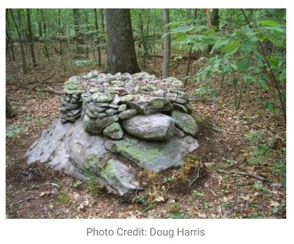
Apparently, I’m documenting Our Vanishing Ceremonial Stone Landscape more than anything else these days. Similar to Eric Sloane writing and sketching about a romantic colonial past, I’m instead blogging about and photographing disappearing features of an Indigenous Cultural Landscape that only a tiny percentage of people are aware of, think is somehow “interesting,” much less worthy of recognition, study, and preservation. I’ve been documenting for years the disappearing Nonnewaug Stone Fish Weir, miles and miles of stonework under powerlines being ground up for road beds, stones popping out of retaining walls at the family home, and now a simple tree fall that knocked apart a formerly very beautiful “Stone Prayer” on a hillside somewhere close to the Madison/Killingworth town line.
In a
recent Face Book post, Karen Lucibello Daigle recorded a bit of video, perhaps in
late winter or early spring, of some tree damage to this Káhtôquwuk or Stone
Prayer that I took a look at once back in 2016:

Captures from Karen’s
video, cobbled into a single image:


Káhtôquwuk or Stone
Prayer on S-Hill:
https://www.flickr.com/photos/34580529@N04/albums/72177720299519377
Mid S-Hill:
https://www.flickr.com/photos/34580529@N04/albums/72157665915629962
Upper S-Hill:
https://www.flickr.com/photos/34580529@N04/albums/72157665814497872
http://rockpiles.blogspot.com/2019/04/some-lines-from-hammonasset-story.html
https://rockpiles.blogspot.com/2022/06/our-vanishing-ceremonial-stone.html

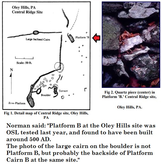
The photo of the large cairn on the boulder is not Platform B, but probably the backside of Platform Cairn B at the same site."


