Wednesday, June 29, 2011

Giants on the Landscape

     The first local Southern Connecticut Giant that comes to my mind is Hobomock, the Sleeping Giant. I see him around from time to time: 

"According to Native Americans of the Quinnipiac Tribe, the giant stone spirit Hobbomock (or Hobomock), a prominent wicked figure in many stories (see Pocumtuck Ridge and Quinnipiac), became enraged about the mistreatment of his people and stamped his foot down in anger, diverting the course of the Connecticut River (where the river suddenly swings east in Middletown, Connecticut after several hundred miles of running due south). To prevent him from wreaking such havoc in the future, the good spirit Keitan cast a spell on Hobbomock to sleep forever as the prominent man-like form of the Sleeping Giant ( Sleeping Giant Park Association.)
http://en.wikipedia.org/wiki/Sleeping_Giant_(Connecticut)
http://cptv2.org/nationalparks/content/keitan-hobbomocks-struggle
(Wiki described the Quinnipiac as Algonquian Speakers, adding on a link that: "The Algonquian Language Phyla was the largest in North America and covered about one-third of the continent above Mexico.")
And then there's this, a better description of why the giant was angry and then Sleepy:
     "Often ancient oral legends have a factual basis. The tale of the giant beaver and the great lake is an interesting example of such fact and fable.

At the end of the last ice age, 15,000 - 12,000 years ago, a large lake covered the Connecticut River Valley (Lake Hitchcock). Also during the last ice age, a giant beaver species, Castoroides ohioensis, lived in the lakes and waterways at the glacier's margin. Based upon fossil evidence, this beaver was the size of a black bear (600 - 700 lbs). In contrast, the present-day North American beaver, Castor canadensis, occasionally attains a weight of 66 lbs. The giant beaver had enormous, convex incisor teeth, extending four inches (100 mm) beyond the gum line. Perhaps this giant rodent was the inspiration for the legends below."

The Giant Beaver (Pressey, 1910)

"The great beaver preyed upon the fish of the Long River. And when other food became scarce, he took to eating men out of the river villages. Hobomuck, a benevolent spirit giant, at last was invoked to relieve the distressed people. Hobomock came and chased the great beaver far into the immense lake that then covered the meadows, flinging as ran great handfuls of dirt and rock at the beaver. Finally he threw a bunch of dirt so great upon the beaver's head that it sank him in the middle of the lake. Hobomock, arriving a few minutes later, dispatched the monster by a blow with his club on the back of the beaver's neck. And there he lies to this day. The upturned head covered with dirt is the sandstone cliff of Wequamps (Mt. Sugar Loaf), and the body is the northward range. The hollow between is where Hobomock's cudgel smote down his neck (http://www.bio.umass.edu/biology/conn.river/nalegend.html)."


Other Giants:
A mural by Stanley Murphy shows the giant Moshup catching a  whale at Aquinnah:
 

Once Called Noepe

   "Martha’s Vineyard, or Noepe, was formed by glacier retreat about 10,000 years ago. Noepe is the Wampanoag word for Martha’s Vineyard. It translates as “amid the waters,” a reference to the two distinct tidal currents offshore.

Wampum from Martha's Vineyard.Wampum from Martha’s Vineyard.


According to the Wampanoags, MV was created by the giant Moshup, who taught them how to farm and fish and set their destiny. Tribal member, Adrieno Ignacio says, “Moshup sustained our tribe. We think he is still there.”


   Moshup (also spelled Maushup, Maushop, and several other ways.) Moshup is a giant who is the culture hero of the Mohegan and Wampanoag tribes (sometimes referred to as a "transformer" by folklorists.) His name is pronounced moh-shup or maw-shup, and he has a wife named Squannit (also spelled Squant, Squaunt, or Squauanit.) Moshup shares some similarities with other Algonquian heroes such as the Wabanaki Glooskap.

   Hobbomock (also spelled Hobbomok, Hobbamock, Hobbamocho, Abbomocho, Hobomock, Hobomoco, Hobbomocho, or other ways): The manito (spirit) of death. A destructive, often evil being usually in opposition to Kautantowit. After the introduction of Christianity, Narragansett people frequently identified Hobbomock with the Devil. He was also sometimes known as Chepi or Chipi.

Thursday, June 23, 2011

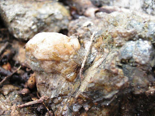
Found in the Stream Bed

- so I don't know if it was humanly created or not.
And I'll never know.
This one is placed in a stone heap.
Could be found, could've been chipped away to look like this.
There's more similar stones placed in the same group of stone heaps.
This one appears to have been both worked and placed in the heap,
the broken pieces beside it:

The Stone Heaps circled in the 1965 aerial photo:


The light colored circles, most likely, are the stone mounds behind my old chicken coop.

Tuesday, June 21, 2011

Edge of the Powerlines

The Pines in 1965.
Both the northern and southern stone rows are visible as dark lines.
 A bedrock outcrop to the southeast of the pines is visible as a bright light colored spot.
Below is aerial photography from 1934, with north at the top:

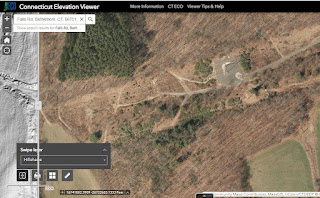
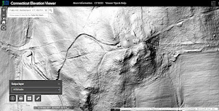
"Last LiDar" added on 11/07/2022:


The Improved Outcrop


see also:


Another set of power lines was added in the 1970's, but here are a few photos just out of range of that construction's disruption of the landscape, presented as if you were walking up hill toward the power lines and the outcrop, in a northeasterly direction...
Looking South West:
Looking north west more or less:

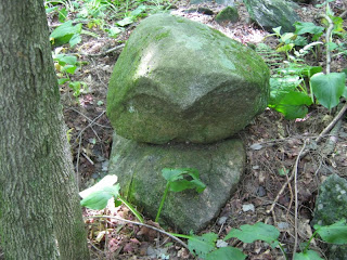
A Split Boulder Once Part of the Bedrock sits on bedrock at the bulldozer edge of the powerlines:
Head stone, 3 marginal scutes, and a larger scute between two huge legs???

Sunday, June 19, 2011

Manitou Quassukquanash (Sacred Stones, Spirit Stones) in the Pines

This is a bit of Land Trust property now called "The Pines," or something like that, captured by aerial photography in 1934 before the Pines were planted. It's 7 acres or so of a hillside terrace above the flood plain. Three sides of it are bordered by Native American built stone rows. A Zigzag Stone Row borders the lower western edge of the property and in the riparian zone are several placed boulders. A small circular stone worked spring is incorporated into this row.. The Norther Border of the Pines is a "musical stonewall" under which a small brooklet flows, perhaps intentionally. This row and the southern border row show similar cultural construction artistry in their details. I have spotted some "cobbles on boulders" on the lower slope in the past and have posted them (somewhere).
On June 16, 2011 I walked through The Pines and noticed some probable Indian Stonework that I had missed before. In the photo above the stone rows are marked and the circle is where the June 16th photos were taken. I had entered from the SW corner and was actually following "the suggestion of stones" both on the ground and, looking again at this photo, on this detail of the frame.

I was looking for "beaks" on stones, especially those that might be chipped, pecked or polished into them - and perhaps naturally occurring marks like that but "Placed So that It Looks Like a Beak."  If you don't look for something, you won't find it. Usually.


Thursday, June 16, 2011

Another Found Turtle Head (or 2)


We have an out building that we call "The Cabin." It's a little two room building, present in the 1934 aerial photos at: http://cslib.cdmhost.com/custom/State_Index.php, built using wire nails and demensional lumber. It is sheathed with milled tongue and groove yellow pine boards and cedar shakes. I believe it to have been built during the Buell Baby Farm Era of my house's long history, when the Stae of CT placed orphans of the Great Depression here with a Mrs. Buell. Each room has a cold water supply pipe of those times and a lead drain pipe as well, a wooden floor in one room, a cement slab poured over the original dirt floor in the other, perhaps because the was once a brick chimney for a wood stove in that room. That cement slab is cracked and broken under where the stove was placed. I've lately been cleaning up that building and found an interesting stone in that spot. In the photo above you can see the old chicken coop, the closest available piles of stones alongside the remains of several connecting ancient stone rows, some of it zigzag.  


Held just right, I though I detected a sort of turtle beak suggestion:
Since I already had two other found turtle beaked head stones, I though I'd store this one with it here at Happiness Farm Cultural Center along a zigzag stone row by this "point" stone where, after transplanting the myrtle, the feet were found in situ. The head stone used to complete the petroform was found on the pavement of the highway just below another zigzag row, just below a petroform box turtle.  
The photo below was taken earlier the same day because it so resembles the one above found under the old quince bush with some other stones...
A few days ago, I had photographed a stone in a massive row  above a row that bordered a swampy area, just below another row at the top of a steep incline because I thought I saw a possible beak on a head stone - as well as a carapce witha a suggested marginal scute (to boot) and a right foreleg.
Then again, could that be a mound of mud brought up by a beaver, spreading to become Turtle Island on top of that carapace stone? If he's pointing to treasure, it's either the Nonnewaug River or the floodplain field now planted with "Uncle ____'s Christmas Trees..."
I'd had these beaks in my mind alot since this post and horribly disfiguring Larry Harrop's beautiful photo:
http://wakinguponturtleisland.blogspot.com/2011/05/more-turtle-visions-inspired-from.html
 
     Originally I wrote, "It's cool this morning, so the project in the sun is my front steps, the stone retaining wall built about 1850, using the dismantled central chimney of the house. These stones show signs of being worked by tools available around 1700 - 1850..." Presently, in January 2023, when I corrected some spelling errors, I no longer think the underlined statement is true. 
     

Another possible beak, partially hidden by the cement?


And from the debris of the 1969 cement steps that capped the 1850's (circa 1700) stonework on the other side, there is a stone (I almost wrote shell) that I've been meaning to photograph:

It reminds me of something...