People ask me often these days, "How do I like the New Nonnewaug Road?"
 I tell them that I doubt that there isn't anyone wouldn't like their "Old Country Road" being transformed into what looks like an Exit Ramp in rural Alabama. I ask them how they liked their tax dollars being spent to pay the additional costs of the project and isn't it great that we now have two curves in the same spot where people continue to drive down at high speeds, like TV detectives, instead of one - the one where all the accidents of the last 15 years have taken place (on Route 61, not Nonnewaug Rd.) and remains exactly the same. We've applied the wisdom of changing Elm Street to fix the problems on Main Street, sort of like the wisdom of attacking a country that had nothing to do with...well, you know what I mean.
Let's just say I liked the old Nonnewaug Road much better...
I made a two part video about the Old Road and the New: http://wakinguponturtleisland.blogspot.com/2008/04/silent-video.html
What troubles me the most was, and is, being ignored: I had asked to be informed, in writing, by mail, about meetings regarding the changes in the road twice at town planning meetings and I was simply ignored because I disagreed with the whole project. If you aren't tired about me complaining about it, you can go back to the "older posts" of a year ago and read them.
In the "Here and Now," there's the Nonnewaug Falls issue that is related to these stone rows I keep talking about. Call it "The Cultural Landscape," or better still, "The Sacred Cultural Native American Landscape." Being ignored about that troubles me too...
Call these "The Blanks Pages in the History of Woodbury, CT."
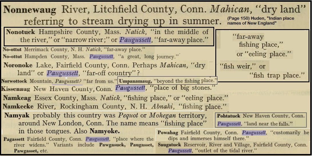
 I suppose that the place to start might as well be right there on the corner of the road that has the sign post, "Nonnewaug." People around here say the name everyday, but what does it mean? It's a descriptive place name, used by the people who lived here in the years following 1672/3, when a group of "settlers" from Stratford moved into the area, originally calling it the "Pomperaug Plantation." According to William Cothren, who wrote the "History of Ancient Woodbury," it means "The Fresh Water Fishing Place." Cothren seems to quickly forget that thought after briefly stating so, and then begins misinforming people that all these things named Nonnewaug are named after the Sachem, or "Chief," Nonnewaug.
 You can read this second illustrated edition of the “Ancient History” by simply clicking on this link: http://www.hti.umich.edu/cgi/t/text/pageviewer-idx?c=moa;cc=moa;rgn=full%20text;idno=apg3269.0002.001;didno=APG3269.0002.001;view=image;seq=4;page=root;size=s;frm=frameset;
(You can also search the title at "Google Books" and come up with other editions.)
What you won't easily find is a description of the stone rows that Native Americans built to control the fires that they used to manage their Sacred Cultural Landscape (unless you search this blog and the other links, like "Rock Piles"). That's because there is a very bigoted opinion that Indians did not build anything out of stone - except for hearth stones and arrowheads - and about a million different types of hand tools - until Europeans taught them to do so.
But you can see a remnant of a zigzag stone fire break as you take "Exit One" off Route 61 (or turn right off of Bethlehem Road onto Nonnewaug Road - or left after slowing to an almost complete stop if you are driving down from Bethlehem):
 This row joined another different sort of row that was also partially destroyed. This straight line or linear row led to the ancient glacial lake shore of tens of thousands of years ago. If you walked down this row and up stream just a little, you'd find another Native American Construction, the Nonnewaug Fish Weir. These were declared "walls of no great importance" by CT state officials in 2006.
I wrote something about that weir and about "Nonnewaug" back in January, 2005 and rather than reinvent the wheel, as they say, I'll just copy and paste it here:
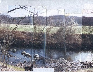
What I think may be the Nonnewaug Fish Weir
Tim MacSweeney
January 2005
Tim MacSweeney
January 2005
 "...I’m just an avocational amateur sort of person, curious about certain stones I see around me in the area I’ve lived in (sometimes also referred to as the Upper Nonnewaug) for over half of my forty nine-years. In June of 1997, I got interested in a diagonal line of stones in the Nonnewaug River that I, like most people in the neighborhood, took for granted. As far back as anyone could remember, this line of stones had always been there, always a nice deep spot for swimming and, according to fishermen, always a good spot for a nice trout. (My brother John relates that my Uncle Bob had shown him that spot long ago, that my Uncle Bob had in turn been shown by his uncle who had lived and fished in the area at the beginning of the 1900’s.) These stones were about four feet long and about two feet wide and high more or less, boulders in the stream, an obvious human construction. I had just seen a series of paintings of Fish Weirs at the Institute for American Indian Studies, and knowing a little about the local history of the area began to think that this row of boulders just might be an Indian Fish Weir.
  Within a month of my realization of what this row of stones could possibly be, a July thunderstorm sent a large tree through the boulders of the Fish Weir, knocking some out of place. I had a few people look at the weir and they urged me to write about it; I made attempts, even had something published online (http://www.neara.org/macsween/weir.htm), but nothing much came of it.
More and more of the Weir slowly washed downstream and I regret not having documented its demise in a more scientific manner, regret not taking more photographs, making more noise about it in order to preserve what may be an ancient structure…
The Word “Nonnewaug”
Without a doubt, one of the most often used local Algonquian place-names used every day in Woodbury, Connecticut is the word “Nonnewaug.” Among other things it is a river, a high school and a school district, a road, and more. A section of the town is still called “Minortown,” but it was originally called “Lower Nonnewaug.” The region that includes the Upper and Lower Nonnewaug was originally called “The Nonnewaug Purchase” in 1700 when the “fourth purchase of land was made from the tribe of Indians called Nonnewaug (“Woodbury and the Colonial Homes.” page 18). William Cothren, describing the layout of Main Street in his 1854 History of Ancient Woodbury, refers to “…the Indian trail leading from the Nonnewaug wigwams to Pootatuck village, passing the grave of Pomperaug…(page 38).”
Despite references to the area of land, the Indian place-name’s origin is popularly known as a reference to a Native American person who lived in the years around 1700 who is mentioned in early Woodbury land deeds and was identified on them as “Nunawauk,” “Nunnawake,” and “Nunnawaoke,” accompanied by “his marke,” that Cothren believes to be a snowshoe, but also bears resemblance to an eel trap. By the 1850’s the person referred to became known as the Sachem Nonnewaug.
The word "Sachem" is traced by linguists to the Proto-Algonquian word for leader, "sa:kima:wa" and "all it’s variations are of a linguistic nature, rather than functional (Bragdon 1996)." Robert Grumet uses the word "sakima" in The Lenapes (1988), and translates it to: "Keeper of the Peace" or "Peace Chief." The man known as Nonnewaug on those ancient deeds was most likely chosen as "Peace Keeper" by the people who settled with him at a place that was known by them as Nonnewaug, a contraction of a descriptive string of Algonquian words, and not the man’s name at all, but rather his title, sort of like calling someone the Mayor or the President, but calling him "New York" or "U.S.A."
William Cronan, writing in his 1983 Changes in the Land, says that Indian place-names in New England “related not to possession but to use (page 65).” The Woodbury historian William Cothren had much the same to say in 1872 in his second volume of his History, “Every name described the locality to which it was affixed…sometimes it indicates one of the natural products of the place, or of the animals which resorted to it…a definite meaning, such as seemed called for by the object named, or the circumstances surrounding it…” Cothren goes on to say, “PAUG, POG, BOG, donates water at rest. But in New England in some instances, it is applied to brooks, rivers, and running streams. AMAUG, denotes a fishing place…From these particles, and others, out of which the local names of our territory were constructed, as well as from local tradition, we may, perhaps, translate our Indian appellations as follows: (which eventually includes)… NONNEWAUG, the fresh pond or fresh fishing place …”
A native Connecticut writer with a PhD in linguistics, Carl Masthay writes in New England Indian Place Names, “One salient ending is -peaq or – paug, meaning ‘watery (p) open area (-aug)…Another salient ending is –tuck, “river (with waves), not to be confused with –uck, ‘land’ or -tuck, ‘tree…Thus we have…Nonotuck (MA), ‘in the middle of the river…’ If Nonne is the same as or similar to Nono -and as Cothren says, “AMAUG, denotes a fishing place” could it mean – and describe-“The Fishing Place (or Weir) in the Middle of the Open Area?”
Update on Nonnewaug (2021):
Yet Another Update on Nonnewaug (2022):

The weir is located on the river at the edge of a floodplain, near what may be the site of the “Nonnewaug Wigwams” Cothren refers to, as well as the associated burial grounds that he describes in his History. (Cothren also describes the graves - stone mounds - and tells how they were destroyed, but he does include a woodcut engraving of one of them in the illustrated volume, so you can see another stone structure made by Native Americans who must not have been informed that "Indians didn't do that." Those of you reading this hoping to rob them yourself can just forget about committing this crime.) The descriptive place name, applied to the location of the stone Weir, as well as local history seem to point out a Native American construction, a fishing place in the middle of an open or cleared area. Cothren writes that “Our fathers… quickly placed the open lands under cultivation, securing good crops the year of their removal… and they quickly overrun all meadow land quite to Nonnewaug Falls.” The early English settlers from Stratford were able to plant because the Native People had already cleared the land. Native People still lived at the floodplain by the Falls, by the weir until the possibly to 1740 when the land was divided into “homelotts,” as documented in Cothren’s History.
 In The Fair Lawn/Paterson Fish Weir from the Bulletin of the Archaeological Society of New Jersey, Vol. 54, 1999, allen lutins and Anthony P. DeCondo write:
“Riverine fish weirs in eastern North America are generally associated with the exploitation of anadromous and catadromous fish. Anadromous fish are those which migrate upstream from the sea to spawn, and catadromous fish (primarily eels) are those which swim from lakes, rivers and streams out to sea to spawn. Fisher (1983:36) characterizes anadromous fish as constituting "probably the greatest density of available food that existed for pre-agricultural societies in the Hudson Valley." They are a particularly attractive resource because spawning runs occur within a highly predictable time frame.
These runs can usually be predicted to within a few days' accuracy (https://www.lutins.org/weir/index.html).” 
Weirs have been documented on the Housatonic River that the Nonnewaug river eventually flows into. In 1947, Claude C. Coffin wrote about stake weirs that were found at the mouth of the river as well as stone weirs farther inland.
He writes:
"(The) mode of construction changed beyond the mouth of the river. At the mouth of the river, the Indians drove the stakes into clay or shell bottom, which held them firmly in place. But up the river, where the current was much stronger and swifter, and the bottom was loose with sand and rocks, the stakes would not stand up for long, for the current washed them out. To overcome this difficulty, the Indians built stone walls out from shore, extending down into the river for almost thirty to forty feet. The walls were built at an angle of about seventy five degrees and heading upstream (Figure 10). Some of the stones were quite large, and it would require two men to handle them. After these walls were built, the stakes were driven between the rocks and in that way the river could not undermine them. At this late date, the stakes have all disappeared. However the walls are still there and can be found at very low tide or when the river is very low in the summer month. I have found two such walls, one at Wheeler’s Farms, in the northwestern part of Milford township, another across the river in Shelton Township, north of the mouth of the Far Mill River. I found still another at Otter Rock in Oxford township below the Stevenson power dam. A friend, Mr. Clyde Batchelor, has informed me that he has seen several walls at Still River in New Milford. That was a famous ground for fishing shad in the early days. There is no doubt that, in the early times, these fish weirs were numerous for miles along the river, as far as the shad and other fish went to their spawning grounds. But today they have all about disappeared. Some of course are buried under mud and sand; others have been destroyed by dredging; while others are under flooded areas where power dams have been installed. Extinct also are the fish that once went up the river by the tens of thousands."

Bragdon, Kathleen J.
1999 “Native People of Southern New England.” University of Oklahoma Press
Cothren, William
1854 “History of Ancient Woodbury Volume I.” Waterbury CT
1872 “History of Ancient Woodbury Volume II.” Woodbury CT
Weirs have been documented on the Housatonic River that the Nonnewaug river eventually flows into. In 1947, Claude C. Coffin wrote about stake weirs that were found at the mouth of the river as well as stone weirs farther inland.
He writes:
"(The) mode of construction changed beyond the mouth of the river. At the mouth of the river, the Indians drove the stakes into clay or shell bottom, which held them firmly in place. But up the river, where the current was much stronger and swifter, and the bottom was loose with sand and rocks, the stakes would not stand up for long, for the current washed them out. To overcome this difficulty, the Indians built stone walls out from shore, extending down into the river for almost thirty to forty feet. The walls were built at an angle of about seventy five degrees and heading upstream (Figure 10). Some of the stones were quite large, and it would require two men to handle them. After these walls were built, the stakes were driven between the rocks and in that way the river could not undermine them. At this late date, the stakes have all disappeared. However the walls are still there and can be found at very low tide or when the river is very low in the summer month. I have found two such walls, one at Wheeler’s Farms, in the northwestern part of Milford township, another across the river in Shelton Township, north of the mouth of the Far Mill River. I found still another at Otter Rock in Oxford township below the Stevenson power dam. A friend, Mr. Clyde Batchelor, has informed me that he has seen several walls at Still River in New Milford. That was a famous ground for fishing shad in the early days. There is no doubt that, in the early times, these fish weirs were numerous for miles along the river, as far as the shad and other fish went to their spawning grounds. But today they have all about disappeared. Some of course are buried under mud and sand; others have been destroyed by dredging; while others are under flooded areas where power dams have been installed. Extinct also are the fish that once went up the river by the tens of thousands."
Nonnewaug Weir Jan. 2005
Conclusion:
The Algonquian place name, it’s proximity to a historically documented village, the Nonnewaug Wigwams, and the great distance between it and the earliest mill suggests that the row of boulders is possibly a native-built construction similar to others across the nation. Some of these stone weirs have been added to the National Historic Register, such as the Indian Fish Weir (Also known as Indian Dam, Indian Fish Trap or Site #13IW100) in Iowa. Natural processes are eroding the Nonnewaug Weir; few weirs have been studied despite their widespread use. A study of the Nonnewaug Weir could add much understanding to the archaeological record.
Conclusion:
The Algonquian place name, it’s proximity to a historically documented village, the Nonnewaug Wigwams, and the great distance between it and the earliest mill suggests that the row of boulders is possibly a native-built construction similar to others across the nation. Some of these stone weirs have been added to the National Historic Register, such as the Indian Fish Weir (Also known as Indian Dam, Indian Fish Trap or Site #13IW100) in Iowa. Natural processes are eroding the Nonnewaug Weir; few weirs have been studied despite their widespread use. A study of the Nonnewaug Weir could add much understanding to the archaeological record.
It should also be added to the National Historic Register.
It should be protected, preserved and studied before it is further damaged.
References Cited:
References Cited:
Bragdon, Kathleen J.
1999 “Native People of Southern New England.” University of Oklahoma Press
Coffin, Claude C.
1947 “Ancient Fish Weirs Along the Housatonic.” Bulletin 21 of the Archeological Society of Connecticut
1947 “Ancient Fish Weirs Along the Housatonic.” Bulletin 21 of the Archeological Society of Connecticut
Cothren, William
1854 “History of Ancient Woodbury Volume I.” Waterbury CT
1872 “History of Ancient Woodbury Volume II.” Woodbury CT
Cronan, William
1983 “Changes in the Land; Indians, Colonists, and the Ecology of New England”
N.Y.: Hill and Wang.
1983 “Changes in the Land; Indians, Colonists, and the Ecology of New England”
N.Y.: Hill and Wang.
Lutins, Allen and Anthony P. DeCondo
Jan. 25, 2005 The Fair Lawn/Paterson Fish Weir.
Jan. 25, 2005 The Fair Lawn/Paterson Fish Weir.
https://www.lutins.org/weir/index.html
Masthay, Carl
1987 New England Indian Place Names in Rooted like the Ash Trees Richard C.
Carlson, ed. 13-17 Naugatuck CT : Eagle Wing Press.
Strong, Julia Minor, ed.
1931 "Woodbury and the Colonial Homes." Woodbury, Conn.: Woodbury
Woman's Club.
Masthay, Carl
1987 New England Indian Place Names in Rooted like the Ash Trees Richard C.
Carlson, ed. 13-17 Naugatuck CT : Eagle Wing Press.
Strong, Julia Minor, ed.
1931 "Woodbury and the Colonial Homes." Woodbury, Conn.: Woodbury
Woman's Club.