Showing posts sorted by relevance for query Hammonasset. Sort by date Show all posts

Friday, August 14, 2015

Can you dig it?

"The Hammonasset River was a main digging ground for the Hammonassett people…"
   
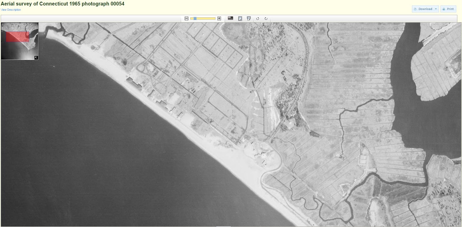
 1934
 1965

Old Native American fish trap West Beach
       Tim Visel writes: “In the late 1970’s, the State of Connecticut sought to expand parking at the West Beach bath houses. To do this, they excavated an area behind the beachfront, and I watched as hundreds of old poles 4 to 6 inches in diameter, were exposed. At the time, I thought I was seeing the remains of a colonial bridge, but now realize that it was an old Native American fish trap that had been preserved in the acid muck of the previous tidal environment. I recall the state park had to send many of its large green dump trucks to carry all the poles from the site. Mr. Miller once told me of a fish trap in the area, but always thought it was Sound side, not in a salt pond behind the beach. The practice of trapping fish in such a tidal breach/salt pond was common by Native Americans. Fish would enter such a salt pond on the incoming tide and be trapped by a big brush fyke trap net. Salt ponds were actually preferred for such “vee fykes” were common to catch alewife, flounder and eels. Many have been found in Maine where the “V” stone wall configuration can be seen on aerial photographs. At the time, I first thought that the original salt pond was being created or restored. My enthusiasm waned as fill was trucked from the site, which yielded a silt-like gray to black sand with many clam and oyster shells, only to be replaced with crushed stone. It was very evident that this area was tidal and even the excavation itself soon filled with seawater, and it became more of a dredging operation that an excavation one. My disappointment yielded a letter to the Army Corps about several projects in 1979 and the need to rebuild, not fill in such salt ponds…

 1893
 1951


Evidence does indicate the presence of Native American coastal fishing village(s) 1,500 to 2,000 feet offshore of the current high tide line. The 1960’s hydraulic dredge operation pumped hundreds of artifacts ashore with the fill. If estimates are correct, since the colonial period, Hammonasset Beach has eroded an average of 2 feet/yearly (from 1900 to 1955, 200 feet; since 1955, around 100 feet). The age of the offshore site is suspected to be around 900 to 1100 AD placing it in the proximity of its current offshore location…”

The First Shad Fishery© by Timothy C. Visel,
 Coordinator The Sound School Regional Vocational Aquaculture Center


More from T Visel:
    "Hammonasset" means, "where we dig holes in the ground" and refers to the place where a settlement of eastern woodland Indians farmed along the Hammonasset River. They subsisted on corn, beans, and squash, and by fishing and hunting. The first colonists arrived in 1639. Property changed hands frequently between Native Americans and the first colonists.
     In 1898 the Winchester Repeating Arms Company bought Hammonasset and used it as a testing site for their new rifle. Their Lee Straight Pull rifle was mounted on a horse drawn stone boat, from which it was fired into targets on the beach.


    On July 18, 1920, Hammonasset Beach State Park was opened to the public. The first season attracted over 75,000 visitors. The park's reputation drew tourists from across the continent as well as the state.
    During World War II the park was closed to the public and loaned to the federal government as an army reservation. Meigs Point functioned as an aircraft range. Planes flew over Clinton Harbor, fired at the range and then flew out over Long Island Sound.
    The stone breakwater at the Meigs Point end of the park was built in 1955. The stones were brought in by truck from quarries in northern New England.
     Today, over one million people come annually to enjoy Hammonasset Beach State Park.


The word Hammonasset means, “where we dig holes in the ground.” Located on Long Island Sound in Madison, the State of Connecticut flagship state park that bears this name was once a sacred place for Native Americans to hunt and fish…

http://www.tlbarchitecture.com/project/hammonasset-visitor-center/


There has been much recent discussion among archaeologists in Connecticut on the chances of finding a predisturbed or moderately disturbed (reused) coastal weir – for eels or alewife.  Many feel the best chance of discovering them is during the stream walk surveys, especially when a 17th/18th century period ice pond is drained on the headwaters of a tidal stream.  The Cove River site in West Haven is thought to support such Native American fisheries and much information is already on file.  Other areas are certain to exist. 
 The “Vee” wall stone alewife traps are easily distinguishable from their location often between two slow moving stream sections that are relatively narrow.  That leaves about a half mile (depends upon slope) between tidal waters and headwaters which was usually a “kettle pond” or deep ponds created as the last ice sheet retreated north about 10,000 years ago.  Alewife needed to reach salt ponds, coastal features that frequently contained “short runs” and “kettle ponds” spring fed are those more often associated as “short runs.”  Alewife would also return into main “stream” larger rivers that would break off into smaller streams, the so called “long runs” each spring as they returned to spawning habitat.  Often these small traps simply look like stone walls built in the stream bed resembling a “vee” apex pointed downstream.  They gathered stream flows to fill it is thought a series of graduated pools allowing fish to ascend into a trap. 


A similar stream survey of Alewife Cove New London/Waterford (the name does give away its former significance) found that the easterly side contained tons of winter street sand and below a layer of approximately six feet of sand lie buried quahogs.  Interviews with area residents (The Alewife Cove Watcher program 1985) indicated that hard-shell clamming occurred here in the 1920s but by 1985 tons of winter street sand had washed into this region of Alewife Cove. 

http://wakinguponturtleisland.blogspot.com/search?q=chaffinch


[1] 1 According to Emil Miller, former park resident, the location of the Grand Pavilion was largely decided by the trolley rail line into the park; straight to the beach was the least costly route. Personal Communication T. Visel, 1968 circa.


Friday, August 29, 2008

Hammonassett Part Two

A little more about the Boulder, which I find is known as Joshua Rock, from an email from Donald Rankin:


"Hi Tim,
Thanks for writing and your interest in Native American culture and tradition. Joshua Rock, located at the entrance to Hammonasset Beach State Park was named by Native Americans for Joshua (a.k.a. Attawanhood) who was the product of the marriage around 1641 between Uncas and the Hammonasset maiden that took place following the Pequot War 1637. Uncas promptly sold Hammonasset land along the water to Col. George Fenwick and Henry Whitfield and moved the Hammonasset folks, perhaps numbering 125 souls, to the Oswegatchie Banks of the Niantic River. Joshua, who later became a powerful Mohegan Sachem himself, fought in the King Philip's War(1675-1676) and died shortly thereafter leaving behind 2 sons and a daughter. Joshua Rock, a chunk of metamorphic gneiss that was earlier iapetos ocean floor that was squeezed and fused to proto-North American in a process beginning 500 million years ago. This glacial erratic, probably from north of Hartford, was tumbled down during the last glacial period and deposited in its present location about 17,000 years as part of a "mini" recessional moraine while the glacial was melting and backing out of New England. Dale Carlson (Abenaki) and I will be part of the Schumann series presented at St. Andrews Church Thursday evenings at 7 PM. I've attached a copy of the flyer. I believe all programs will be well attended. "
Best,
Don
Googling around, I found the blog entry of Melissa Pionzio, from June 12, 2008, where I learned a little bit more about that big boulder at Hammonassett and why it had been recently cleared:
“Here's Madison resident Phil Janssen, a really great guy I met today, who has been spending some of his free time removing tree stumps at a future park near the entryway to Hammonassett State Park.
Phil got involved in stump removal/grinding at the site, after he learned about the project from his friend and neighbor Don Rankin.…Rankin, a retired medical doctor, has a great interest in geology and Native American culture (being of Native American descent himself). Over the years, he's been keeping an eye on a huge and beautiful boulder that has been sitting on the site for just about forever. It's been dubbed by the Native American community, Rankin told me, as "Joshua Rock" after the son of "Uncas" a well-known leader of the Mohegan tribe.
Here is Joshua Rock, it's really something! Much better in person (or in Tim Macs’ photos)...

… Phil has finished removing about 50 stumps at the site and Dr. Rankin, a Vietnam War veteran, says he would like to see Joshua Rock and the surrounding grounds it sits on, become a place where people can come to commemorate the state's many service men and women."

http://blogs.courant.com/itowns_mr/2008/06/madison-man-likes-to-help.html

And an unidentified writer says this of Attawanhood:

"The genealogy of Uncas is found in Trumbull ( 1885: 101-4 ) This document created by Uncas in 1679,with English legal assistance
Sons: Uncas had at least three sons, Oneko ( Oweneco) the oldest,who went to Boston with about fifty other Mohican warriors (including his brothers Attawanhood and Ben who were held hostage at Cambridge until the Mohegans proved themselves loyal) to join the Colonist against Philip in 1675. He succeeded Uncas as sachem of the Mohegans. He died in 1715 at 70 or 75 years of age
John, his second son
Joshua or Attawanhood, his third son, sachem of the Western Nahantics. His residence was at Lyme, Conn. near Eight Mile Island in the Connecticut River. Died 1776
http://members.aol.com/mpied31415/nanapashemet.html
And from Carolyne's Native American Genealogy Helper, I find an anglicised name that turned the man's Native American name into Atwood, surprising me because my house is listed in some old Woodbury histories as "an Atwood House," with probably no connection at all but coincidence:
Attawanhood aka Joshua ATWOOD

Note:
It is believed by some of our family researchers that Attawanhood, also known as Joshua, is the father of Philip Atwood. At present the evidence is circumstantial, but seems to fit.
Attawanhood, alias Ahaden, aka Attawahn, aka Attawan, aka Joshua Uncas (3rd son of Uncas Sachem of the West Nihantics) Wife Unknown (English Speaker)Children 3 (2 Sons unnamed, but known to be inlaws of Robbin Cassassinamons of the Peqout) Daughter (Indian Papers Vol. 1.30) or 2 Daughters A Man Called Sampson.According to the "Genealogy of Benjamin ATWELL of New London Ct. 1664" By Norm Ingham in an issue of THE GENEALOGIST), the cousins of Lucinda ATWELL received land in Old Saybrook as a grant of the Proprietors "of land set aside for the children of Attawanhood" He being the 3rd son of Uncas and the captain of the Mohicans that saved TREAT'S men in the Battle of Bloody Brook".
Attawanhood was kept as a hostage in the confined area of the colonists families following an Indian attack. He lived with the Atwell family. From "The Lyons Family", pg. 9-10:WILLIAM PRATT, JR., accompanied by his brother, John, came to America with the Rev. Thomas Hooker, in 1632, settling at Cambridge, Mass., then known as Newton. In June, 1636, they left with Rev. Hooker and travelled through the wilderness, establishing Hartford, Conn. William Pratt, Jr., was a member of the company from Hartford that defeated the Pequot Indians in 1637, annihilating their power as a tribe. He represented Saybrook in the General Assembly for twelve consecutive years. In his will, Attawanhood, third son of Uncas (Chief of the Mohegan Indians and friend of the English) recommended his children to the care of Robert Chapman, William Pratt, Jr., and Thomas Buckingham. In about 1640, William Jr., married Elizabeth Clark, daughter of John Clark, of Saybrook and Milford. William Jr., died in 1678.
· Change Date: 20 SEP 2007Marriage 1 Spouse Unknown
Children
Phillip ATWOOD b: ABT 1649
From:
http://wc.rootsweb.ancestry.com/cgi-bin/igm.cgi?op=GET&db=carolynegould&id=I12411

Tuesday, May 01, 2018

The Dreaded Hammonasset Imaginary Line


   Almost against my will, I’m reading a recent publication gifted to me by a friend, almost against my will, - and not too long into it, there it is again! The Dreaded Hammonasset Imaginary Line, connecting certain places to this and that, and eventually to an advanced ancient and unknown worldwide megalithic culture that “diffused” across the planet, just like Donovan was singing about in that song about Atlantis.
   Mythical Atlantis.


   Odd that the record company artwork for the jacket for the single 45rpm features a swastika, right??

    Here's a little bit of nationalistic psuedohistory, used by a particular branch of pseudoarchaeology, that troubles me when people start talking about Atlantis, and a made-up "race" of people: “Homo atlanticus was a white, ancient Aryan race that came from Atlantis...Popular television series like Ancient Aliens and Secrets of the Dead continue to explore the Tiwanaku-Atlantis connection. Bestselling books by Erich von Däniken and Graham Hancock go further, attributing the construction of Tiwanaku to ancient extraterrestrial beings.
     Though it may be hard to stomach, the survival of the Atlantis myth is certainly not surprising. Plato’s Lost City has proven both timeless and universal in the western imagination. Its timelessness lies in its capacity to reveal the mysteries of human origins; its universal appeal, in its unlimited imaginary potential. And lest we forget: the legend of Atlantis evolved alongside dangerous theories of race that reinforced white supremacy for Aryan nationalists and Bolivian creoles alike. Attributing the construction of Tiwanaku to ancient extraterrestrial beings only perpetuates this nefarious myth. When we wonder if Tiwanaku was built by Atlanteans or by Aliens, those assumptions are based on the same twisted logic that drove men like Díaz, Posnansky, and Kiss: that Andean peoples could not have built Tiwanaku.

     And that’s the greatest myth of all.”

From “Andean Atlantis: Race, Science and the Nazi Occult in Bolivia”
By Matthew Gildner – Published June 5, 2013

    Eventually someone, if it hasn't already happened, is going to connect one silly line or other to Atlantis, "where ever she may be." Or the Antarctic ice cap will melt to reveal the lost city with all it's UFO landing sites and German U-boats equipped with Egyptian microwave ovens, proving me wrong, resulting in even more books and TV shows:


    But back to that book and that imaginary line people seem to like so much: My friend wanted me to see this particular photo in this particular book. This particular imaginary line never seemed to be in my particular yard before, at the junction of my road and Bethlehem Road:

     I’m thinking that I would have missed so much following an imaginary line instead of following real rows of stones, Snaking across the Landscape. The originator of this Hammonasset Line Hypothesis believes “(t)he line passes a notch in this large ridge (somewhere) and crosses Cheshire and Waterbury. It continues to Mount Tom, which is located just west of Litchfield and then crosses over into New York State passing by Red Hook to the Catskills by Hunter (Mountain). There is a large standing stone on the line just before Hunter that is called the Devil’s Tombstone... There seems to be some common threads along this line. There seems to be some complex about every three miles. The complexes are north of the line such as cairn fields. Some stonewalls are at the end at the line. The line does not seem to be a set width; it appears to vary in width. The actual solstice sunset line should be moving in a southern direction at this time due to precession. This means that the line from the past is located northward from the current sunset line. Some walls and marking boulders point to 70° magnetic northeast, the summer solstice sunrise.”
    “The line does not seem to be a set width; it appears to vary in width.” I’ll agree with that, propose a corrected version if you want to find some Connecticut Indigenous Stonework, a line wide enough to include this large Indian Rock Garden from pre-contact times:
You'd be better off listening to the Landscape Speak for Itself, learning about the ways Indigenous Peoples "tended the wild" with controlled burns, following streams and rivers, from the high places to the low, to each ecological resource zone (combination Church and Garden) surrounded by a protective spirit being that resembles a rattlesnake, sometimes with horns, sometimes with feathers, composed of stone... 

Tuesday, August 26, 2008

Hammonasset


At the State of CT website they say, "Hammonasset" means, "where we dig holes in the ground" and refers to the place where a settlement of eastern woodland Indians farmed along the Hammonasset River. They subsisted on corn, beans, and squash, and by fishing and hunting. The first colonists arrived in 1639. Property changed hands frequently between Native Americans and the first colonists."


But Wikipedia comes closer to what I'd remembered it as: (Hammonassett) "place of sand bars," just as it says at:


I sort of remembered it as (The place of) the long sandbar, but just can't remember the source.

But I do know you dig holes to get clams and that corn, beans and squash were planted together in mounds, but then again you'd dig a hole to build a fire in a stone lined pit, wait for it to turn to coals and cover them with seaweed, add what ever you harvested including clams and other seafood delights, plus some corn, cover that with seaweed and wait a while before you have a seaside clam bake, just like has been written about the excavations on Pilot's Point.


So I've just returned from a week long camping trip at the Hammonassett Beach State Park, noticing for the first time in a life time of camping there, the Great Big Boulder at the east of the entrance and the short row of stones on either side of it, plus what looks like a nice little clambake spot at the edge of the salt marsh. These pictures are from the entrance at Route 1, and you'll note the saw horses and screen in one of them, as well as a Rock Pile I can't really say is old or new. There have been excavations there, dated back 7,000 years from the present, but I haven't read any of them (and I was going to add something here about the nearby airport, but suddenly I can't copy and paste what I wanted to)...


And I'm adding this just because there's familiar names in it:

Friday, August 19, 2016

Hammonasset Line

     
I was looking at the Hammonasset Line Chapter 1: A Summer Solstice Sunset Line; A Field Report by Tom Paul (2001) New England Antiquities Research Association

     Rather than a line, I see Indigenous Stonework as more like a spider web, connecting yet separating the Sacred Landscape - a big New England sized rock garden...

Look at the oldest of maps, before the Indian Place Names were “ethnically erased:”

   Maybe “Where the basket trees are” in a Algonquin dialect becomes 'Black Ash Swamp'
Until it’s dammed and called Foster’s Pond

“Hill of the Stone Turtle” becomes Buell’s Hill
        And those Guarding Stone Serpents slowly disappear
And another bit of the Great Eastern Garden is forever gone...