Watertown CT Historian Charlie Crowell writes, “Here’s an old “zig-zag” stone wall that runs along an abandoned section of the Old Baird Road (aka. “Old Middle Road”) in Watertown (CT). This wall, or “stone fence” as early settlers would have called it, dates back to colonial times...Ancient pieces of split rail fencing still rest on top of the wall. Barbed wire, which came much later, is also present.
The Old Baird Road was part of a stagecoach route from New
Haven to Albany. During the American Revolution, the route was used to
transport wagon loads of military supplies, presumably headed to the Battle of
Saratoga in 1777. Soldiers marched along with the supply wagons..."
[Lifted, with permission, from the widely read Watertown History Page by Charlie Crowell:
https://www.facebook.com/p/Watertown-History-Page-by-Charlie-Crowell-100060847285557/]
I'm going to suggest that this roadway, bordered by what remains of "rows of stacked stones" may have originally been an "Indian Trail" - or really an "Indigenous Highway," one of many "Native American Paths" that were used by early settler colonists that have since become modern roads. I'm going to suggest that there is Indigenous Iconography used in the stacking method of the "stone fence" that reveals it as a carefully constructed Ceremonial Stone Landscape feature rather than an accidental feature related to stones being tossed up against a the wooden rails of a "Snake Fence," as zig-zag stone fences were conjectured to have been formed, as suggested by Eric Sloane and other writers/historians:
In recent years, the idea that Indigenous Peoples of northeastern North America (or Turtle Island, as it was known as for a long, long time) did not make "large scale" stone constructions has come into question, and may well prove to be a great fallacy. The "zig-zag stone fence" has always intrigued me and really was one of the features of what has come to be known as Ceremonial Stone Landscape that I can't help but critically observe, here in the Nonnewaug or CT Cluster #3 as Curtiss Hoffman calls it in his inventory of possible Indigenous Stone Constructions in his book, Stone Prayers (2016). I've searched in vain for an actual messy conglomeration of stones in zigzag manner that would suggest field or road clearing stones thrown up against early post contact era wooden rail "Snake" or "Worm" fences and to this date have only found carefully constructed zigzag rows of stones (see the numerous posts in this blog). The "landform signature" of these zigzag rows of stones on Old Baird Road on LiDar images is a "regular and even" shape all too often assumed to be a sign of a "farmer's wall" by many researchers both professional and avocational:
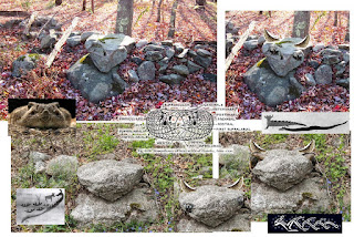
Ground checking the rows of stones, this "point" of a zigzag suggests that these may be Indigenous in nature, perhaps fuel breaks and protective barriers infused with the power of a Great Horned Serpent:
Qá
qusuqaniyutôk nohkshô:
“And the stone wall was broken.”
Prov. 24:31,
Mamusse Wunneetupanatamwe Up-Biblum God (“Eliot Indian Bible”)


%20snakefence.jpg)


No comments:
Post a Comment