skip to main
|
skip to sidebar
Waking Up on Turtle Island
Indigenous Ceremonial Stone Landscapes of Turtle Island
Wednesday, September 21, 2011
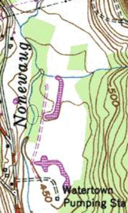
Aerial and map Images of Nonnewaug Weir
(Above: Weir circled in white. Below: Weir circled in red ~1965)
Before (above) and (below) after the Bulldozers changed the contour lines:
Weir in center of image, appearing as light colored boulders on river bank, sometime before 2007. A facing west view can be found by clicking here:
http://www.bing.com/maps/?v=2&cp=qy0x1f8x1zbz&lvl=19.509761358382203&dir=274.6620815808467&sty=b&form=LMLTCC
No comments:
Post a Comment
Newer Post
Older Post
Home
Subscribe to:
Post Comments (Atom)
Contributors
Tim MacSweeney
Tim MacSweeney
Blog Archive
►
2026
(8)
►
June
(1)
►
May
(2)
►
April
(1)
►
February
(1)
►
January
(3)
►
2025
(32)
►
December
(2)
►
November
(2)
►
October
(3)
►
September
(3)
►
August
(3)
►
July
(1)
►
June
(2)
►
May
(4)
►
April
(3)
►
March
(4)
►
February
(3)
►
January
(2)
►
2024
(39)
►
December
(2)
►
November
(1)
►
October
(5)
►
September
(3)
►
August
(5)
►
July
(2)
►
June
(5)
►
May
(3)
►
April
(1)
►
March
(2)
►
February
(4)
►
January
(6)
►
2023
(88)
►
December
(6)
►
November
(4)
►
October
(8)
►
September
(2)
►
August
(2)
►
July
(3)
►
June
(7)
►
May
(9)
►
April
(8)
►
March
(15)
►
February
(15)
►
January
(9)
►
2022
(63)
►
December
(5)
►
November
(4)
►
October
(5)
►
September
(3)
►
August
(2)
►
July
(2)
►
June
(4)
►
May
(5)
►
April
(7)
►
March
(2)
►
February
(10)
►
January
(14)
►
2021
(50)
►
December
(6)
►
November
(7)
►
October
(10)
►
September
(4)
►
August
(1)
►
July
(1)
►
June
(3)
►
May
(4)
►
April
(5)
►
March
(7)
►
January
(2)
►
2020
(45)
►
December
(3)
►
November
(6)
►
October
(5)
►
September
(4)
►
August
(5)
►
July
(2)
►
June
(4)
►
May
(2)
►
April
(1)
►
March
(6)
►
February
(6)
►
January
(1)
►
2019
(48)
►
December
(6)
►
November
(5)
►
October
(1)
►
September
(4)
►
August
(6)
►
July
(2)
►
June
(2)
►
May
(6)
►
April
(6)
►
March
(5)
►
February
(2)
►
January
(3)
►
2018
(95)
►
December
(7)
►
November
(5)
►
October
(9)
►
September
(5)
►
August
(5)
►
July
(4)
►
June
(5)
►
May
(9)
►
April
(8)
►
March
(16)
►
February
(13)
►
January
(9)
►
2017
(102)
►
December
(16)
►
November
(6)
►
October
(10)
►
September
(10)
►
August
(4)
►
July
(4)
►
June
(1)
►
May
(6)
►
April
(10)
►
March
(18)
►
February
(5)
►
January
(12)
►
2016
(170)
►
December
(24)
►
November
(12)
►
October
(11)
►
September
(14)
►
August
(18)
►
July
(15)
►
June
(11)
►
May
(16)
►
April
(16)
►
March
(13)
►
February
(10)
►
January
(10)
►
2015
(158)
►
December
(10)
►
November
(13)
►
October
(15)
►
September
(23)
►
August
(14)
►
July
(19)
►
June
(12)
►
May
(5)
►
April
(9)
►
March
(12)
►
February
(12)
►
January
(14)
►
2014
(131)
►
December
(8)
►
November
(15)
►
October
(13)
►
September
(7)
►
August
(8)
►
July
(5)
►
June
(8)
►
May
(19)
►
April
(12)
►
March
(10)
►
February
(15)
►
January
(11)
►
2013
(125)
►
December
(4)
►
November
(7)
►
October
(19)
►
September
(8)
►
August
(10)
►
July
(7)
►
June
(12)
►
May
(11)
►
April
(8)
►
March
(28)
►
February
(5)
►
January
(6)
►
2012
(107)
►
December
(1)
►
November
(11)
►
October
(5)
►
September
(8)
►
August
(5)
►
July
(3)
►
June
(6)
►
May
(7)
►
April
(12)
►
March
(5)
►
February
(22)
►
January
(22)
▼
2011
(134)
►
December
(12)
►
November
(9)
►
October
(17)
▼
September
(28)
‘Canada’ and the ‘United States’ Are in Turtle Island
Stylized Drawing of Fishweir (A Nutty Idea)
Sleeping Buffalo Boulder (MT)
Aerial and map Images of Nonnewaug Weir
Fish Weir Village
A Macrobotanical Analysis
Nonnewaug Fishweir Photos; A Stake at a Fishweir a...
A Few Downed Trees
Nonnewaug Fishweir 9/17/2011
Glooskap and the Frog
A prehistoric clam garden
Sucarnoochee River Fishweir
Pre-Columbian Fish Farming in the Amazon
Nice Photos of Stone Fish Traps
Heiltsuk stone fish traps: Products of my ancestor...
Hunters and gatherers? – not a chance!
The Edible Seascape
Stone Plummets or stone fishing weights
Prehistoric Fish Weirs (GA)
Indian Corn Mill Traditions and Lore
Mikchichk
Legends of the Micmacs
"What (turtles) we see depends mainly on what (tur...
The Legend of Glooscap's Door
Chaffinch Island Boulders
The Power Point Discussion
Hammonassett Stone Remnants of Fish Weir
Chaffinch Island Weir
►
August
(11)
►
July
(2)
►
June
(8)
►
May
(10)
►
April
(12)
►
March
(8)
►
February
(8)
►
January
(9)
►
2010
(81)
►
December
(2)
►
November
(5)
►
October
(22)
►
September
(25)
►
August
(1)
►
June
(1)
►
May
(3)
►
April
(4)
►
March
(10)
►
February
(7)
►
January
(1)
►
2009
(117)
►
December
(8)
►
November
(18)
►
October
(15)
►
September
(11)
►
August
(6)
►
July
(8)
►
June
(6)
►
May
(15)
►
April
(13)
►
March
(3)
►
February
(5)
►
January
(9)
►
2008
(76)
►
December
(1)
►
November
(2)
►
October
(3)
►
September
(4)
►
August
(7)
►
July
(2)
►
June
(2)
►
May
(5)
►
April
(13)
►
March
(14)
►
February
(12)
►
January
(11)
►
2007
(89)
►
October
(1)
►
September
(12)
►
August
(11)
►
July
(5)
►
June
(12)
►
May
(11)
►
April
(8)
►
March
(11)
►
February
(6)
►
January
(12)
►
2006
(48)
►
December
(2)
►
November
(5)
►
October
(8)
►
September
(5)
►
August
(8)
►
July
(11)
►
June
(9)
Links
My Flickr "Stone Features" Albums
Rock Piles
DOUG HARRIS: Indigenous Ceremonial Stone Landscapes
Sokoki Sojourn
The Nolumbeka Project
CT LiDar Viewers
Celebrating Ceremonial Stones Landscapes
Stories and Stones
Larry Harrop
Secret Landscapes
Pre-historic stone works in the Town of Catskill
Hopkinton (RI) Historical Association
Stone Ceremonial Landscapes
The Stone Structures of Northeastern United States website
A New England Woodland
Carl Bjork's Rock-Art Site
Ron Smith Photos
Traces in the Woods
Tispaquin's Revenge
Institute for American Indian Studies
Primative Technologies
Schaghticoke Tribal Nation
The Corner Report
Massachuset
Indigenous Politics: From New England and Beyond
Nonnewaug Falls
The Deer With Horns Site


No comments:
Post a Comment