(Rows of Stones on a Talus or Scree covered Slope, sometimes connected to boulders or tors)

In the mid-1800’s, Woodbury CT historian
William Cothren wrote: “Orenaug is the name of the beautiful trap-rock cliffs,
which bound the village on the east. The front cliff has been recently
purchased and improved by the writer, as a mountain park. Oak, maple, hickory,
chestnut, and cedar trees are scattered over the mountain-top, and in the
beautiful ravine beyond, while the crest is covered by a beautiful grove of
pine trees, in the midst of which a tower, thirty feet in height, has been
erected, from which views of six surrounding towns may be obtained. It has been
named the Orenaug Park. Here one can always catch a delightful breeze, and
enjoy a beautiful panoramic view of the village, valley and meandering river
below, while the whispering pines above his head sooth the perturbed, wearied
and overworked mind. The beautiful evergreens suggest thoughts of peace, and
the beatitude of the eternal rest on high:
"As the softened land-breeze marches,
Through the pine's cathedral arches."
A few moments walk to the south-east,
through a pleasant grove, over the second cliff, brings the visitor to the
celebrated 'Bethel Rock," in the bosom of these cliffs, of which more will
be said hereafter. A more lovely and romantic spot, even without its sacred
associations, cannot easily be found.”
(The "sacred" Cothren is talking about is best explained here: https://youtu.be/-DY-V7T0KSI)
I had a few moments after a visit to the
Town Offices, to walk up from Main Street (originally a game trail for
mastodons that became a major Indian Trail aka the Connecticut Path) toward the
“mountain” mentioned. I crossed some old stone walls that have been mangled,
maybe rebuilt, maybe robbed, and now serving as a convenient place to dump brush,
old chunks of concrete and asphalt. I was looking for “sacred associations” - features
of the Ceremonial Stone Landscape in this section I hadn’t walked before.
I came to a row of stones, probably
modified sometime after 1672 with a wooden cross and rail (stake and riders) fence
to make it somebody’s “improved” and legally owned property, probably a pasture
for horses or cows but who knows, maybe it was a hay field meadow or perhaps it
was plowed and planted with something, corn or maybe tobacco.

The "simple" explanation that this is an example of "stones tossed under a cross and rail fence" (possibly re-stacked later to "pretty up" the long piles of refuse at a later date) sounds complicated, while the idea that a pre-existing Indigenous was appropriated by the later addition of wooden rails may be argued using the Law of Parsimony.
I hoped to find a “gateway” in the row of
stones and in the distance I could see an opening:

So, yes, that is a larger triangular
boulder, with that other sort of long stone I often observe and don’t have a
name for. “Collar” comes to mind but snakes don’t wear collars although it
could be a fold in the skin of a snake just behind the head, and you could use
it to hold up some antlers or pieces of branches that might represent horns.


The other side is no longer intact – and if I
were making some simple deductions about it, I’d say the gate opened toward the
uphill side and those piled stones came out of the cart path into the hayfield
(sorry about the blurred image) and probably were tossed aside because they
were impeding the movement of the gate. Probably the gate rested on it:

Nearby I
came to a junction of an intersecting row of stones:

This row
leads east toward the trap rock cliffs that are popular rock climbing
destinations – if you don’t hurt yourself (break your talus bone?) climbing
over the talus slope (“a slope formed by an
accumulation of broken rock debris, as at the base of a cliff or other high
place, also called scree,” as Wikipedia believes) to get to them.
I was
observing the stacking pattern, looking for the suggestion of eyes for effigies
as well as the “making a snake pattern” – a stone or combination of stones
suggesting a snake head and smaller stones stacked to make a tapering in size
body and snake tail.

"Combination of Stones" sometimes includes an artistic variation that shows the jaws of a snake:

"Jaws" may even include the suggestion of rattles...

This row
also had a sort of gate at its high point, but it looked messy and messed with,
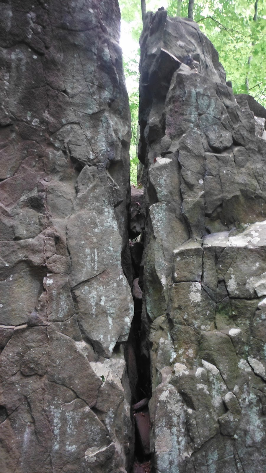
a metal stone drill mark suggesting a boulder had been split. I have to admit
to being distracted by the view down into the ravine:

Above: western face of split boulder.
Below: northern face of the same split "filled" boulder.

Yes, that is a heap of stones at the base of the boulder. And yes, there seems to be a row of stones purposely piled at the edge of the talus, sometimes just cobbles, sometimes just boulders and sometimes both. Most of my captured images are too blurry to post.
Except for these:


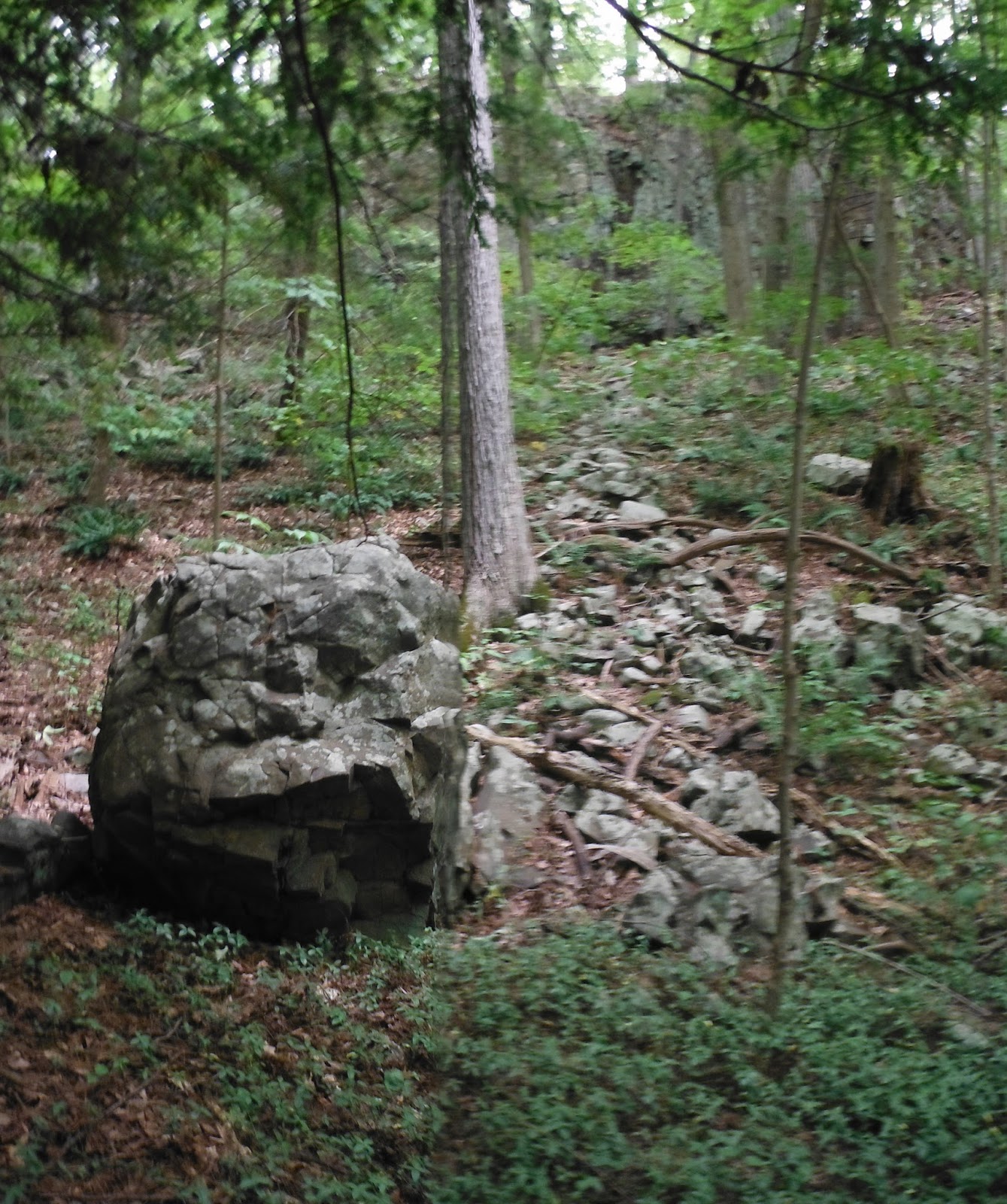
Above: Wedged stones??
Below: peeking north from the east side of the split boulder, cliffs in the distance.


Above & below: Noticable "linking or connecting stone rows between boulders/tors...

Here and there, sometimes rows of stones are built on the talus, connecting to the cliff face.
I doubt that these are related to farming practices. They may have been property lines that were appropriated into the historic record after 1672 when the English showed up and sold to Cothren toward the end of the Golden Era of Stonewall Building.


Had I just followed that first intersecting row of stones, I would have landed at this spot:

Another "over the talus" row that begins with a possible snake head:

The Snake Overlay:

No comments:
Post a Comment