
Early
Thanksgiving morning, after the snow fell, I was looking at a photo collection
called “The Meandering Stone Wall,” taken a couple years ago on Martha’s
Vineyard, tagged Chilmark, MA, USA. They are quite nice photos, found here:
It was way to
look at what just about everybody calls a stone wall, a way to take a virtual
walk when I knew that day I couldn’t, a snowy day when I traditionally do a
bunch of cooking. But I am me, prone to look for those Indigenous patterns of
stacking stones, on a long pile of stones that in part just might have functioned as a fuel
break that was a way to control the fires that those Indigenous Peoples used to
tend a landscape marveled at by those earliest of post contact visitors to what’s
now called New England.
In Ed Thrayes fine
photos I was looking at what stones where chosen to build that collection of
stones, how they were placed on others, perhaps mark or pit a hint of some
possible human enhancement of the cobble or boulder, softened by couple hundred
years (at least) of weathering. I was looking for effigies you could say,
examining each stone or group of stones in that longer than wider stacked
segment of stones, looking for zoomorphic or animal-like qualities, even anthropomorphic
or human-like ones, conducting my ever evolving Waking Up On Turtle Island Test.
Is that stone
placed like that because it resembles the head of an animal culturally important
to Indigenous People, such as a bear or a deer? Are those marks in the stone
natural or did someone work that into the stone, sometime in the past so that
the effigies’ eyes or mouths were represented, a sort of sculpture you might
say?

Is that a
combination of stones placed so to resemble a turtle?


Is that a stone turtle head and two stone turtle forefeet beneath a stone turtle shell?


Is there a large boulder end stone to the row, possibly
reminiscent of snake head?
There’s another gallery here: http://edtrayes.com/2012/08/stone-walls-of-chilmark-marthas-vineyard-massachusetts-usa/,
where I find I have seen Ed’s work before as I see a photo of a gateway I was
just looking for, adding another possible indicator of possible Indigenous
Stonework: the use of quartz, particularly as a head stone of a turtle
(petro?)form.

I somehow
stumbled into an article about New England Stone Walls (where there is absolutely
no mention of Indigenous People inhabiting the landscape or the last 15,000 years
or so) during an image search using meandering stone walls in the search field.
An excerpt or
two:
“Although New
England’s stone walls are popularly associated with the Colonial era, there
weren’t actually many rocks lying around in the soil at that time. As evidence,
Thorson cites Swedish botanist Peter Kalm, who toured New England in the
mid-1700s. In his “Travels in North America,” Kalm observed of its forest
soils, “[T]he Europeans coming to America found a rich, fine soil before them,
lying loose between the trees as the best in a garden. They had nothing to do
but to cut down the wood, put it up in heaps, and to clear the dead leaves
away.”
Likewise,
Colonial-era books on farming, encyclopedias and recorded observations do not
mention stone walls, Thorson notes. Instead of stone walls, Colonial farmers
used rail and zig-zag fences made of wood — far more abundant at the time than
stone — to pen animals. It wasn’t until the latter half of the 18th century
that early stone walls were first widely constructed in New England. Even then,
other than in long-farmed interior areas such as Concord, Mass., the stone was
typically quarried or taken from slopes rather than from fields.
The region’s
stones lay deep in the ground, buried under thousands of years’ worth of rich
composted soil and old-growth forests, just waiting to be freed by pioneers
clear-cutting New England’s forests — a process that reached its peak across
most of New England between 1830 and 1880.”
“These stones
weren’t conducive to farming, so, aided by their oxen, farmers hauled the
stones to the outer edges of pastures and tillage lands, typically
unceremoniously dumping them in piles that delineated their fields from the
forest. (Some of these so-called “dumped walls” would later be relaid more
intentionally when improved tools and equipment made rebuilding easier.) In the
early days, artistry in stone wall building had to wait. The first priority was
survival, which meant clearing land to grow crops and raise livestock.
The types of
stones and their abundance may have been familiar to those early farmers, who
were mainly from the British Isles, Thorson says, because rock in New England
is similar to rock in England and Scotland. England and New England have
similar natural landscapes because both lands have a similar geologic history.
Millions of years ago, England and New England were formed within the same
mountain range near the center of Pangaea. So, he says, “the similar
fieldstones on opposite sides of the Atlantic were created practically within
the same foundry.”
But there was one important difference between these New
World and Old World stones: Britain had long been deforested, with its
subterranean stones brought to the surface, so its stone walls had been
constructed hundreds, if not thousands, of years…”
“A March 2014
study in the Journal of Archaeological Science offers a fascinating glimpse of
what lies beneath the forests that now envelop many New England farms abandoned
in the latter half of the 19th century.
Using a laser
mapping technique called lidar that can see landscapes even through dense
forest cover, University of Connecticut geographers Katharine Johnson and
William Ouimet conducted aerial surveys of the heavily forested areas of three
southern New England towns. The researchers found remnants of a former
“agropolis,” vast networks of roads and stone walls that have been hidden for
more than a century beneath the dense cover of oak and spruce trees….”

Well, I wondered
if there was some LiDar of the Vineyard, so I tried another search that brought me - in an entirely different direction - to Belize: http://www.mdpi.com/2072-4292/6/9/8671/htm
And this image (that I first thought might be New England in that little preview that comes up):

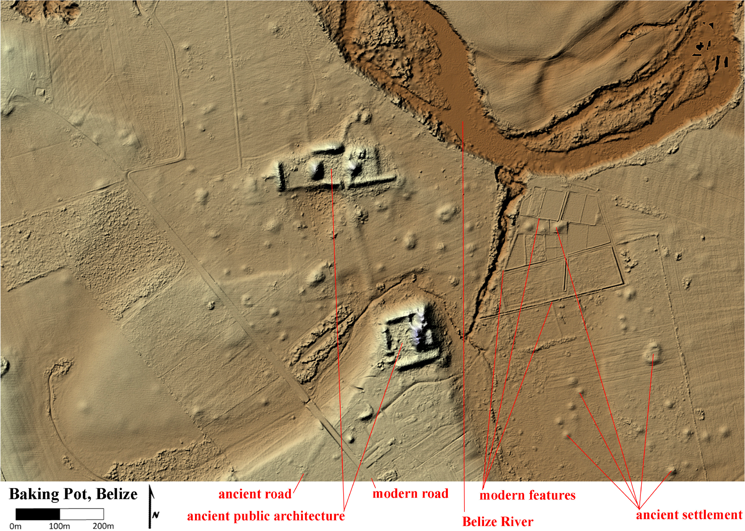
I thought back to another bunch of
LiDar images I’d seen, back
to a series of blog posts I’d seen here: http://www.retired--nowwhat.com/2014_05_01_archive.html
Even some “on the
ground” photos of some featured stone constructions: http://www.retired--nowwhat.com/2014/05/stone-walls-photo-addendum.html
and a link to the source of the photos:
Putting the
photos to the Turtle Test isn’t easy because of the size of the photos; I don’t
see lots of details. But I see a similarity to some “stone walls” that are
featured to some others that I have seen close up that pass the Turtle Test
(that includes far more cultural symbols and representations than just
turtles).
Like here where I just happen to have kindly been given a
LiDar image and have links to “on the ground photos:” http://wakinguponturtleisland.blogspot.com/2014/11/serpent-gateway.html
No comments:
Post a Comment