The encircled area below is known in my family as the Old Horse Field on my great grandfather's farm. My Uncle Bob remembers an old barn foundation there and tells me that he was told that the barn burned - down with the horse inside it. I didn't find the foundation...
Revised Drawing 11/01/2022:
...and the "field" has been growing in with successive growth as long as I can remember. The zigzag row of stones at the edges of field, along the road has been plundered, as has the northern edge's row, but the outlines are apparent still.
Stone at northern edge
The western edge butts up against a north/south ridge of rocky outcrops that at first glance appear natural, but the closer one looks, the more it seems that human hands have been busy building rows, singling out certain stones that seem propped in position...
The most distinct stone row is at the base of the outcrops, more or less a linear row with some extensions back into the horse field, as above. The stone in the center of the above is a quite notable stone, inside a circle of stone, as in the close ups below...
Above: these stones are actually just above the row at the edge of the field/base of the out crop.
There is a spring that flows out of this row. A family member probably made the ditch you see here above. Below a detail of where the water emerges...
Looking up, I could see what turned out to be another stone row at the top of the north/south running outcrop. I thought at first it might be a stone heap or pile...
A segment of an east/west row of stones (above), has a large "head stone" pointed east is about 25 feet long, suggesting perhaps a snake or serpent petroform. This row of stones, seen closer below, has an interesting stone at it's eastern end...
Visible to the south as I stood by this petroform was a (perhaps) 12 foot diameter circular mound that caught my eye; my first impression was that it two circular mounds, one to the east and one to the west:
The large mound sort of tuned me into others on this "terrace."
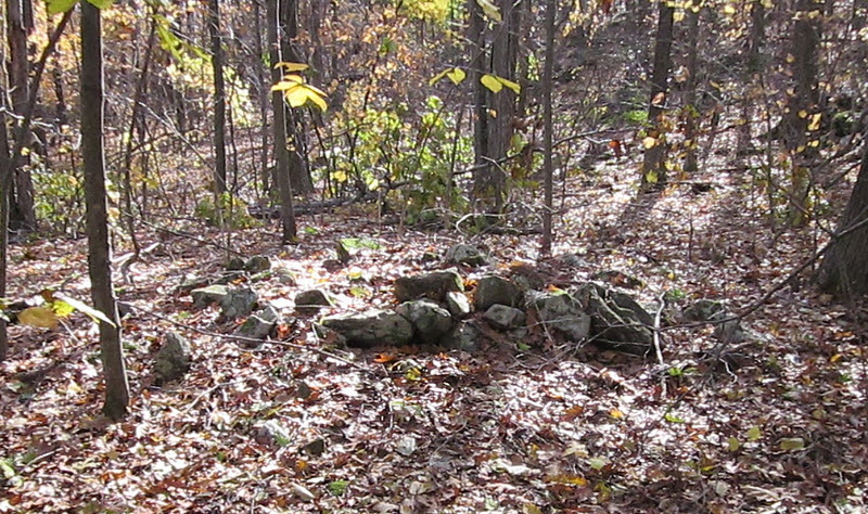
Above, looking north, the mound seemed just a "pile of stones."
Below, looking west, the mound's turtle-like nature became obvious to me...
Above: a lower shell, or plastron, supports a "head stone" with a suggestion of eyes,
and above a nuchal notch "marginal scute stone."
A friend who is the spiritual advisor of the most likely descendants of the People who most likely created this petroform suggested I offer some tobacco and gently clean it off to see if there are possibly stone representations of 13 scutes (moons) on the turtle's back...
Another of many "stone mounds."
This little terrace that contains these mounds has an eastern/western border stone row a little above it, suggesting containment of the cultural burning probably used to maintain the site.
I wonder what the other side borders...
...the artistic stacking of the cobbles in the row suggest to me the "Indian Look" of Native American built constructions (rather than that of English Colonists or my Italian American ancestors in this case)...
(Above: a possible "bird stone" inspired this post:
There will be another post about zigzag rows along the trail, flanked on both sides of the road that led to "a fishing place" on Quassapaug Lake, on what is known today as White Deer Rocks Road. One possible translation of the word "Quassapaug" suggests "Stones in the Pond," by my friend Carl Masthay, although this morning the possibility occurs to me that it could be a short (English) version of a longer Indian Place Name for "The Great Pond
by the White Deer Rocks."
"Quassapaug: a large pond in the n. w. part of Middlebury, partly in Woodbury; the source of Eight-mile river...Neither of the interpretations suggested by Mr. Cothren, —" Rocky pond," or "Beautiful clear water" — are admissible. Dr. Anderson, in Orcutt's Derby, xcvi, proposes qunnosu-paug 'pickerel pond,' to which the only objection is that after names of fish, -maug 'fishing place,' was used, instead of -paug 'pond,' or -tuck 'river.' The Rev. Azel Backus (Account of Bethlem, 1812, Ms) interpreted the name, as "signifying Little pond" — but he certainly was wrong: Quassapaug is not a small, but the largest pond in that region, and may have been denominated k'che-paug, i. e. 'greatest pond'—a name easily corrupted to Quassapaug (mod. Quaspaug)."
From: "Indian names of places" By James Hammond Trumbull (Pages 59-60)
Note on 11/01/22:
I almost replaced "stone mound(s): with Káhtôquwuk or Stone Prayer.
As I understand it,
Káhtôquwuk means, allegorically, a 'Stone Prayer.'
Some are said to be“Invested with prayers for the balance of the universe.”
A káhtôquwuk is a kind of stone pile,
a kind of stone heap, something that is heaped high, ceremonially, religiously,
by placing one stone above another stone.
Káhtôquwukansh is the plural of “Stone Prayers.”
http://wakinguponturtleisland.blogspot.com/2022/03/kahtoquwuk-stone-prayers.html