Sunday, June 21, 2015

Obed's Hammock and Clam Gardens


So I’m thinking “Are there any CT clam Gardens??
So suddenly I’m thinking of the Menunketeset River in Westbrook CT where I spent not enough time every year “hunting and gathering” Blue Crabs.
(Westbrook CT above, Pot Hook Creek below.)

So I go to those aerial views I can find, see how they compare to the Clam Gardens of Pot Hook Creek, to see if there are any visual similarities.

      And I think, “Well, maybe. Maybe those just might be something like that,” up the river from the Village once known as the Hawk’s Nest, maybe sometimes called Obed’s Hammock or maybe just confused with another place in Saybrook and I get lost a little trying to “Google it down:”

    "The quarter was set aside to provide farm and pastureland to residents of Saybrook Point. Permanent settlement soon followed. The area became known as Pochough, a Mohegan word meaning "at the confluence of two rivers,'' the Pochoug and the Menunketesuck rivers, home of Chief Obed and his tribe. The area has long been home to Native Americans, and a large village was at Hawk's Nest, now known as Pilot's Point..."  http://www.courant.com/hc-ot-westbrook-htmlstory.html
The Gages: http://www.stonestructures.org/html/pilots-point-stone-mounds.html


     But I get back to those images, and I move around in location - and in time, as my friend d.c. in Delaware sometimes does and has shown me how.
Or go to 1934:

Look for yourself up close: http://binged.it/1fqoyyb
And feel free to move in and zoom around.
And I’m still thinking maybe.
And I’m thinking “Could I get in there with a canoe or a kayak and sort of look around?”
And I’m thinking of all that stonework all around there on the dryland above those salt marshes, trying to recall if I’ve ever seen any extending into the salt marshes, wondering if there just might be some clam gardens in there.
Especially in the National Wildlife Refuge:
McKinney Sea Turtle?

    “Why not?” I’m thinking, despite all the dredging in the river and all the mosquito channels in the salt marshes - and the next terrace or two above the marshes where some pretty good examples of Indigenous stonework remains if you have the eyes to see it…


Friday, June 19, 2015

Solstice Stones, Stonehenge, and Patch Hill

    One of the things about identifying Indigenous Stone Features is the “purposeful placement” of stones, whether it’s a tiny turtle (or bear or bird or a rhomboidal quartz stone) placed on a mound or a boulder or a row of stones or a large combination of boulders/stones that creates what people often call a “calendar.”
    All over the world, our human family has created these sort of things in the past and because it marks a certain solar event on a certain date we assume that that is what the creators were doing so we call Stonehenge a giant calendar and we assume that some big celebration took place on that event – and people will dress up (or get either naked or semi-naked) and flock to some of these places and have some sort of pagan party:
     (“Pagan Writer” – and former head of the American Nazi Party - Francis Joseph "Frank" Collin is probably washing his white robes right now so he can show up at some place or other in the mid-west, maybe the Great Serpent Mound or Cahokia, reminding us all that it was some white Aryan Tribe that anciently sailed to what is now called “America” to smarten up the savages and bring them a higher degree of civilization, thanks to this Master Race. It’s a good thing that the man has reformed his evil ways and is no longer spewing hateful bigoted propaganda built on misconceptions. Google him if you choose to get totally depressed knowing the man is well funded unlike legitimate researchers focused on empirical evidence, sadly proving the "real money" is in pseudoscience - and that there really is a sucker - or seeker - born every minute…)


    I know of one place that is a definite “triangle of stones,” three large boulders and some other smaller stones as well, which is good because the “viewing stone” has been moved from its original placement, knocked out of place by someone I know who used to mow the trails used by a Fox Hunt Club. Some barely visible smaller stones possibly form a line of stones along the sight line to a boulder that marks the Equinox sunset as well as to another standing stone sort of boulder that marks the Summer Solstice or “Solar Stand Still.” I’ve seen the Spring Equinox sunset occur over the Equinox Stone(s), but never the Summer Solstice. “No one is taking care of the place,” as a 500 year old elder who might have one time lived in the area might say, so trees block the view of the Summer and Autumn sunsets.

     And I wonder what that 500 year old Elder would say about the calendar sort of function – would he or she say, yes this marks the time of this and that? Or would the Elder tell me all the other hundreds of “signs” for proper times to perhaps plant corn or fish for a certain fish heading up (or downstream) such as the size of the oak leaves or the blooming of the shadbush trees (or the dark of the Eel Moon)??
     

    Some people expand on the stone markers, draw lines from them out across the big blue world, connect them to other places and cite the significance of such a link, sometimes even to Stonehenge if I recall correctly, but I tend to think a little differently about this. Would the Elder tell me about places these stones point to?
     Or would the Elder instead point me in the other direction, standing there in the Heart of the Village (as Burial Grounds are sometimes called), toward the circle of my heart as I stand inside that triangular stone device centered in the circle of the universe?? The Heart of the Universe??

    I can answer that one easily: “I don’t know.”

    Now this was all prompted by a Rock Pile post or two:
and you will note that in the comments of that second link I asked if there were another stone (or more) involved in setting up the triangulation that contributes to that purposeful placement of stones since you can walk around any old stone and line yourself up with a sunrise or sunset over the stone (or other feature of your choosing). I had asked that same question this past September about the Autumn Equinox up on Patch Hill in Boxborough MA : 


    I still don’t know, but I sure do know that there’s a great deal of suspected Indigenous Stone Landscape Features up there on Patch Hill. I wouldn’t be telling the truth if I told you I remembered this one especially; it seems that lately the only thing shorter than my short term memory is my short term memory, but there’s a species specific very realistic musk or stink-pot turtle stone up there:


    There's also a possible mortar boulder, the “pestle” stone(s) still sitting in place maybe:


     And all the other things you can find looking through the Patch Hill posts at Rock Piles, including the many comments some of them generated: http://rockpiles.blogspot.com/search?q=patch+hill

    And having recently made the acquaintance of Glen Mellin and Lenny Truitt, a husband and wife team of Ethnoecological Researchers (who it turns out are independently funding themselves, sort of in the same kayak with no paddle as many Rock Piles independent researchers find themselves up the creek in), I noted right away this statement in the Town of Boxborough’s web-page about Patch Hill:
“Patch Hill Conservation Area is the largest conservation parcel owned by the Town of Boxborough. Patch Hill Conservation Area also likely ranks highest for wildlife habitat and overall bio-diversity, supporting numerous vernal pools, rare species, several types of forest community, and protecting the headwaters of Guggins Brook. Patch Hill itself, also known as Goat Hill, is a glacial drumlin, the summit of which is either the second or third highest point in Boxborough, depending on the source of information consulted.”

   Do those rows of stones up there have anything to do with some Indigenous plant resources (or Traditional Land and Resource Management areas (TLRMs)  organized within larger,
territory based TLRMs) maintained by anthropogenic fires - and Ceremony, of course, not "farmers' stone walls" but Great Serpent Petroformss guarding the Gardens??

Thursday, June 18, 2015

No Stones on the Big Sandbar (Delmarva Peninsula DE)

East Coast Clam Gardens

       “Hello Tim,” Glen Mellin writes, “Although most clam gardens associated with aggressive slopes have supportive rock walls, the Delmarva Peninsula is little more than a very large sand bar. In Delaware, we have archaeological evidence of one stream valley that appears to have been especially productive for harvesting hard shell clams. We conducted an ethnoecological survey of this area (see attached) and we think we have discovered a constructed and maintained clam garden. Keep in mind we are talking about waters and a bay area with water depths of less than 3 meters deep, there is no need for a rock wall and there are no available rocks here anyway. Nevertheless, our clam garden essay is a good attempt at discussing the importance of studying clusters of living species as artifacts, with DNA.
       Mostly we study clusters of Chestnut, Chinquapin, Prickly Pear, Jimson Weed, Box Huckleberry, Walnut, Persimmon, Cohosh, Paw Paw, and a host of others. Archaeology and pollen studies show that many of these plants were not in Delaware ca 4000 years ago, but they were in Delaware 2500 years ago…”
       So there it was, no stones.
       But I was still fascinated with what Glen and his wife Lenny had to say about an Indigenous Cultural Landscape, despite being suddenly hungry for some clams, specifically quahogs.

      In The Clam Gardens on Pot Hook Creek (South of Cape Henlopen, Delaware), Glen and Lenny Truitt (December 2014) tell us that the “quantity of cultural clamshell debris found on Pot Hook Creek is substantial, perhaps the largest known accumulation of clamshell debris within the State of Delaware. Other, smaller deposits of clamshell are recorded on discrete sites elsewhere along the Coastal Bay and Delaware Bay river systems. However, we recognize the difference in proportion of clamshell debris from location to location as being meaningful.
      Measuring Native American clamshell debris can be an obtuse and cumbersome task. In this essay, we measure Native American clamshell debris by the dump truck load, an approximation of twelve cubic yards. We use this method of measurement for overall visual effect, not for its scientific accuracy. Thus, when we speak of small sites with small cultural clamshell deposits, we suggest these deposits are within the range of one to ten dump truck loads. When we speak of cultural clamshell deposits at The Townsend Site and the Wolfe’s Neck Site, we are talking about cultural clamshell debris in the range of hundreds of dump truck loads. We therefore view Clam as a cultural keystone animal in Delaware, especially at these significant sites on Pot Hook Creek (Page 12).”


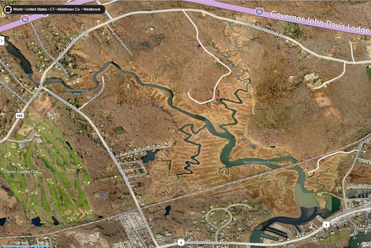
    Speaking of “overall visual effect,” I just had to look for some aerial views of these gardens:
    So this Caltopo view, a mash up of satellite and topographic map imagery gives you a” picture worth hundreds of dump trucks full of words,” as the old saying goes.
   “Hokey Smokes!” I exclaimed. It really does look like dozens and dozens (some even Baker’s Dozens) of seeming garden plots.

Glen and Lenny tell us:
     “We use the word garden, because it implies the concept of cultivation. As Webster’s (1967:202) defines cultivate, as “to prepare or prepare and use for the raising of crops”, we suggest our clam garden model contained tidal areas set aside for the cultivation of clams. Today, these proposed clam garden areas along Pot Hook Creek have unfortunately accumulated massive amounts of silt where they have been transformed into salt marshes (see Maps 3 and 4).


 "Obviously, in Delaware, years of future research could be applied to asking questions concerning clams found along Pot Hook Creek, as well as the ancestral Native American contexts in which they are embedded. What do the contents of the various shell‐middens and other cultural features tell us about who was doing what through time? What made this particular back‐bay location a suitable place for the sustainable production of shellfish? We should also be asking a wide range of environmental questions, such as; how and when did this back‐bay form in relation to the littoral repositioning of Cape Henlopen; what were the effects of past sea level rise; what will happen to this locale if subjected to terrestrial development or additional Army Corp dredging?
How will this locale be impacted by projected future sea level rise?
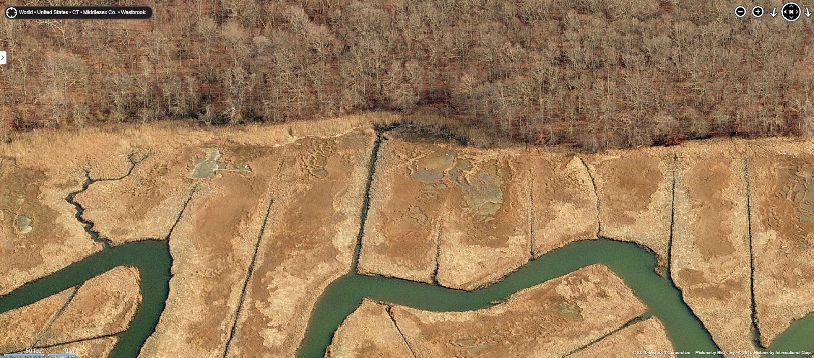
Closer view - what about those almost evenly spaced shrubs or trees??


The process of ancestral Native American clam gardening should be addressed wherever we find evidence of huge amounts of cultural shell debris. We need to be judicious in describing evidence of shell debris because the quantity of shellfish debris over time is important. We need to address whether a cultural deposit represents successive cultural inheritance of a managed location, or are we looking at a small deposit representing an isolated, short‐term singularity. Turner (2014, V1:212) reminds us, “Clam beds, carefully built up to extend their area and productivity, were created and sustained on many parts of the coast (Fowler and Lepofsky 2011; J. Williams 2006; Recalma‐Clutesi 2005). Quantifying successive sustainability is likely the key element that differentiates clam gardening from clam foraging!


We also think that clam gardening would regulate the division of labor where elders, women, and children (arguably three quarters of the total available population) contributed more directly to food procurement. Turner (2014, V2:55) says, “This may have endowed these groups (elders, women, and children) with higher status and possibly shifted the power relationships within families away from the stronger, more dominant male who hunted in groups with other men and toward a more balanced social standing across gender and age groups.” How do these suggestions oppose or agree with previously assumed social strata for these cultures in this locale? Do these suggestions add to or take away from our ideas about material, ceremonial expressions commonly referred to as “Delmarva Adena”?

This clam gardening program, along with berry gardening, maintaining other fruit orchards, and nut groves is perhaps the strongest indication of gender biased, or matrilineal organized economic properties we have thus far suggested in Delaware. The waste debris found in the shell‐middens on Pot Hook Creek is an indicator of what was being processed. Species such as razor clams, conch, scallops, ribbed mussel, etc. were likely cleaned out of the clam beds and probably contributed to edible food stocks. Harvested clams, however, represent a strong bias toward large, adult clams. We can only assume the small and medium sized clams were left behind as breeding stock, as they are woefully under‐represented in artifact databases and collections. We think selectively harvesting only large clams represents a regulated clam harvest size. This form of garden management would harvest adult clams that will not grow larger and produce ample room for juvenile and small clams to reach maturity. We think this form of management could increase the yield of the clam beds at least fourfold. Such management programs designed to increase sustainable yield are consistent with other examples of matrilineal organized economic properties where reliable, owned, and inherited resource based Traditional Land and Resource Management areas (TLRMs) are organized within larger, territory based TLRMs.


Clam garden management, or shellfish stewardship implies the cultivation of harvestable clams within a storable shellfish economy, promoting enhanced economic predictability with a large degree of permanence, even if permanence is based on a repetitive seasonal basis. Such factors might enrich trade and exchange networks and result in elaborations of ritual, ceremonial, and mortuary practices. Williams (2008:1) said:
•             “The clam gardens were one of the foundation blocks of aboriginal economy for specific coastal peoples. If they are accepted as an essential cultivated and privately owned unit of Native economy, a term like “hunter gatherer,” which has been used by social scientists to define Northwest Coast Native society, must be reassessed.”


This is why we are making a profound distinction between clam foraging and clam gardening.

We strongly suggest our idea of clam gardening involves regulated selective harvesting and cultivation. Our Ethnoecological explanation of clam gardening as an anthropogenetic landscape, or TLRM property simply cannot be properly addressed using the moniker “hunter gatherer,” Glen and Lenny conclude.

    As a student of Connecticut Stone Walls, as well as Cultural landscapes, who challenges the accepted view of stone walls and an empty landscape before 1492, I particularly like Glenn and Lenny's motto when it comes to making observations:  Nulliusinverba, sapereaude, carpediem
( Seeforyourself, daretoknow, seizethe day). 
     Not entirely ignorant after three years of Latin I, I already new the meaning of carpe diem, but I had to look up "Nullius in verba" for the more literal translation of  "On the word of no one" or "Take nobody's word for it," which I stick to when it comes to stone walls (as you may have noted). As far as “Dare to know” or “Dare to be wise” goes, well I know a little bit and a true wise person knows that there's much more that's unknown than is known...

Monday, June 15, 2015

Clam Gardens June 2015


For many years, archaeologists were unaware of the ancient clam terraces at Waiatt Bay, on Quadra Island. Author Judith Williams knew no differently until she was advised of their existence by a Klahoose elder named Elizabeth Harry (Keekus). By liaising with other observers of clam gardens in the Broughton Archipelago and conducting her own survey of Waiatt Bay and Gorge Harbour on Cortes Island, Williams has amassed evidence that the rock structures seen only at the lowest tides were used by native peoples for the purpose of cultivating butter clams. Her research does much to challenge the notion of pre-contact West Coast indigenous peoples and hunters-gatherers alone. The clam gardens whose existence she reveals here might also be unique in the world.  http://www.amazon.com/Clam-Gardens-Aboriginal-Mariculture-Transmontanus/dp/1554200237

    I love the story of Clam Gardens and how they have become objects of study, especially because they are Indigenous creations that employ “stone walls” around a resource zone – and that they were “re-discovered” by a retired art teacher who kept pestering archaeologists about them until her "amateur" observations led to the acceptance of the whole deal. In a way it’s a similar function that I ascribe to many certain Indigenous rows of stones created to maintain certain resource zones such as certain swamps and streams (and possibly salt marshes where I often see interesting rows of stones with that “Indian Look” as I drive by at low tide), but of course obviously it’s water and not fire involved as it is in more upland sorts of places. One of my favorite Stone Terrapins sits on one of those Indigenous Rows of Stones above one such salt marsh in a Connecticut State Park in Madison CT:

    (And you know, now that I think of it, perhaps that Chaffinch Fish Weir down in Guilford CT was a combination Fish Trap and clam garden. Hmm, I’ll have to ponder on that…)
     So, yeah, these accepted clam gardens are up in Canada, on the north western coast of Turtle Island, but by chance I happened to hear of an archaeologist in Delaware who just might have come across at least one east coast clam garden, the details of which I know absolutely nothing about. So this post is also sort of a way of getting in touch with the fellow, just like my new Bio for my new band will also serve as an obituary – once I get around to actually writing it…
    I did kind of Google around for anything I could find and did come across this, not mentioning any stone walls but using the term clam garden as well as perpetrating a common thought that the Indigenous People who once lived and clammed there are long gone:
Clams and Clamming
By Gustav Kobbe
     “The boys and women of Parkertown (on the Navesink River, N. J.) practice more primitive methods of capturing clams. They rake, hoe, or tread for them. These means can be employed only in shallow water—water shallow enough for wading. The raker, or hoer, uses the ordinary implements of agriculture, but instead of cultivating a vegetable garden he is tilling a clam garden on the bed of the river, wading as he does so. Treading for clams is the special occupation of women. You will see a barefooted woman pull her boat from Parkertown half-way across the river to the little sedgy island which is part of the Sandy Hook reservation, and, having clambered over the gunwale, wade in the shallow water, towing the boat behind her. Every now and then she will reach down into the water and then throw the clam on which she has trodden into her boat. Some women who are not fortunate enough to own a boat tread in the shallows along the Parkertown shores with a tub in tow…When, in 1609, Henry Hudson anchored the "HalfMoon" in the Horseshoe at Sandy Hook, he found clamfishermen there. They were redskins of the Lenni Lenape tribe. The Lenni Lenapes have long since disappeared, but the clam-fishermen are still there. They live in little shanties built on small scows to which they tie their boats. They drift down in their shanties from Parkertown in the early spring, and drift back again in the late fall…” (Page 811 of https://books.google.com/books?id=8-UhAQAAMAAJ&pg=PA46#v=onepage&q&f=false)

I did come across this site that is new to me – and that I find both really interesting and encouraging as an independent or avocational Indigenous Stonework Researcher:
      “The Clam Garden Network is a group of First Nations, academics, researchers, and resource managers from coastal British Columbia, Washington State, and Alaska who are interested in the cultural and ecological importance of traditional clam management practices and features, including clam gardens. We share ideas, research approaches, tools, and data to better inform our knowledge about how people used intertidal resources and ecosystems. We see clam gardens as a compelling focal point for a series of linked current social issues, such as food security, First Nations governance, and inter-generational knowledge sharing….
Indigenous people of the west coast of North America used a range of techniques and practices to maintain or increase the production of culturally important foods, including clams.  These practices are encompassed within age-old social, economic, and spiritual beliefs and practices of coastal First Peoples. One long-lasting and visible practice was the building of clam gardens.

Photo: Mary Morris.

Photo and Image: Amy Groesbeck.


     Clam gardens are ancient intertidal features constructed by the coastal First Nations of British Columbia (Canada) and Native Americans of Washington State and Alaska (USA), to enhance shellfish productivity. These features are made by constructing rock walls at the low tide line along the edges of bays and inlets, transforming naturally sloping beaches or rocky shorelines into productive, level beach terraces. While clam garden morphology, character, and setting can vary greatly, they generally consist of a well-sorted boulder wall built at the lowest tide line and a terrace on the landward side of the wall. By building the walls at particular heights in relationship to the tides (“tidal heights”), these features expand the zone of the beach where clams thrive. According to local knowledge, clamming beaches, including those associated with clam gardens, were kept clear of large rocks as another means to increase clam habitat. The flattened terrace created by garden walls can range in size from a few square meters on small beaches to well over a kilometer in length. These larger beaches are more like vast fields than ‘gardens’ in size.
Clam gardens are sometimes visible from Google Earth satellite images. Photo: Dana Lepofsky.

    There are probably hundreds, if not thousands, of clam gardens that have yet to be recorded along the northwest coast. Rising or dropping sea levels, lack of surveying, and industrial development of the foreshore are among the main reasons why modified beaches are yet to be identified in some regions.  Mapping the locations of these features is slow-going. Given that most clam gardens are situated at today’s low-low tide levels, there are only about 40 to 80 daylight hours per year (May – September) when they are visible. Nonetheless, clam gardens have been recorded or observed from Alaska, through British Columbia, and into Washington State…”
      I liked this very much as well:
     "Gví'ilás" is an Heiltsuk word for customs and laws concerning the sustainable harvesting of Heiltsuk resources for sustenance, cultural, commercial and recreational use. The remarkable stone fish traps, still evident on many Heiltsuk beaches (left), are an example of how intensively salmon fisheries were stewarded. Heiltsuk archaeologist Xanius (Elroy White) presented an academic paper at the annual conference for Northwest Anthropology in April 2008, describing the use of stone traps to form holding pools for migrating chum salmon. Increasingly such ancient indigenous structures are used to prove Aboriginal Title and Rights. The presence of fish weirs and clam gardens is proof of extensive and careful management, of food resources being "gardened" rather than gathered in the "wild." This is an important change in perspective with implications for treaty negotiations and land claims. European settlers mistakenly viewed land in the new colony as wild and uninhabited and therefore up for grabs. The clam gardens at Gale Passage, between Athlone and Dufferin Islands, have been continually harvested commercially by Heiltsuk clam diggers (right). Non native forest activist Ingmar Lee describes them as "demonstrating a sophisticated understanding of stonework engineering designed to withstand centuries of continuous, albeit gentle tidal action. They absolutely abound with clams; at first glance I estimate they have increased the clam habitat by as much as 30 percent and also they enhance the ability of the clams to grow bigger and faster."
Clam gardens, Gale Passage, 2007.
Photo: Ingmar Lee


Some other links:
Large clam garden terrace in the Canadian Gulf Islands 
shows the extent of foreshore management by Indigenous people of the region. 
Image Courtesy of Phys.org.
Andrew and Tom. The low rock wall and flat beach of a clam garden is clearly visible. Photo © Katya Palladina

And many thanks to Mike StandingWater for passing on the name and email for Glen Mellin. 

Friday, June 12, 2015

Ai'nt got nothing like that 'round here!!


   I saw this post the other day, maybe yesterday, on the Face Book page of the Connecticut Archaeological Society, prefaced by the grammatically strange statement in what’s called a status box, a ghostly little thing that appears at the top of each page asking “What’s on your mind?” sometimes or “Write something…”

  A credentialed CT Archeologist wrote: “Ai'nt got nothing like that 'round here!!” and provided (pasted) a link to
Archaeologists find vast medieval palace buried under prehistoric fortress at Old Sarum, just as pictured above (You copy and paste the URL and Face Book turns it into a preview photo and some text for you, an easy thing to do).

   More than anything else, it made me feel sad.
   I’ve got these wandering feet that have taken me many places in (what is now known as) Southern New England since I was old enough to do so that always were and still are best described as a “Wonderland.”
   And the first thing I thought of to reply to this post was something like, “Yes, we do! Open your eyes!”
   It’s just a question of being open enough to see past that same old rhetoric about “stone walls” (and “stone piles”) as exclusively post contact constructions, really opening your eyes and mind to the obvious differences between a “tossed row of stones resulting from field clearing” and a carefully constructed Petroform Serpent (or memorial pile) containing certain elements of style or design found in other Indigenous artwork, created sometime in that other 97% of time that humans occupied what they called Turtle Island.
   I understand how most people are most comfortable repeating what someone else has said about just about everything. So do those people responsible for what you hear and see on your television. Why do you think they call it “programming?” Original thoughts are harder to come by and it is just so much easier to repeat something you heard.

   I suppose that fellow’s statement in one sense is true: we don’t have any English medieval palaces ‘round here. I’m not going to post up something about America’s Stonehenge but rather a place that I know well, the first place I thought of that in some way reminds me of that Ol’ (Olde?) Sarum illustration, something I used here:
   Those lines of defensive walls at Ol’ Sarum remind me of the Serpent Petroforms illustrated in the inaccurate lay-over above. And you may note well the power lines in the lower left corner, a disturbance to the bigger picture of this Indigenous Cultural Landscape below the present one.
   A fanciful overlay, also very inaccurate, that I don’t think I used anywhere else:

   Left to right on the hillside, sometimes called Nonnewaug’s Hill, there were decorated balds of outcrops, a rockshelter sort of out crop, a little green blob that represents two massive oak trees that might relate to the Treaties of 1700 (maybe even earlier, like 1672 when the English arrived) and 1710 and the blue representation of a waterfall (really a series of three falls), all above some first terrace areas of land still used as hay fields, bordered by Serpent Petroforms that functioned as fuel breaks as well as with the power of the Great Serpent(s) that sometimes suggest control of the weather, above the former horticultural fields that were not appropriated by the English in 1659, had to wait until 1734 when the last Indigenous inhabitants began gathering at perhaps Schaghticoke (or perhaps even farther away). It’s an incomplete picture of course – there is so much more up there and all ‘round here, radiating outward, always something of great wonder just beyond every “stone wall” I walk along on this inter-connected landscape created by generation after generation of Indigenous People created over 12,000 years or so.
   I do indeed feel sad and maybe the kindest thing to do is to is to invite you (and any archeologist who might either be just as adamant that there “Ai’nt nothing like this ‘round here!” or has seen something similar somewhere else – like perhaps the Ceremonial Stone Landscape up by the Great Falls (Turner’s Falls) in Massachusetts – to come take a look at just what still is here near the Late Woodland/Contact Village of the Nonnewaug Wigwams by the Old Connecticut Path.

   I might even take you to see this Tobacco Sacrifice Stone I once showed you a photo of:


There is something 'round here, different yes, but it's a kind of Wonderland in it's beauty:
Leaves fall from the trees and a Wonderland appears
You can see the long distance stretch of rows of stone
Snake through the wounded forests of this part of Turtle Island
And I wonder, “What was gathered there?”
And I wonder, “What song was sung in Thanksgiving?”
And I wonder, “Who lit the sacred fire
That sent prayers to the Creator and the Spirit of the Deer
Gathered in that Sacred Circle of that Sacred Fire?”

Wednesday, June 10, 2015

(No Protection for) ONE OF THE MOST IMPORTANT SITES IN NORTH AMERICA

I watched the following video as the moon was rising last night, up over the hill to the east where the power company is bulldozing away components of what in a civilized country would be part of a protected Sacred Site with Indigenous stewardship...
   "While the site is on both the Nat ional Register of Historic Places and the International Register of Threatened Sacred Sites, the site lacks professional protection because it is on private land.
   The United States is one of the few civilized nations which does not make significant heritage sites public property. Countries like Canada and Australia for example make heritage sites and objects part of the national domain. In Australia, such sites are Aboriginal property, with Native custodians.
   Another of the pressing needs at Hensler is financial support. It has never had any. So far the excavations have been undertaken by amateur and volunteers under volunteered professional supervision and guidance. Since prehistoric rock art, even at remarkable sites like Hensler, is not in the public picture, it is very rarely the object of significant support. Sometime, somehow, this important Native American site should receive some quality backing to ensure its heritage nature to the population at large..."
Posted on Oct 18, 2014 by Diane Graff


Published on Jun 8, 2015
From Wisconsin's endangered Hensler Petroglyph Site. The Sacred Ground Documentary Series, produced by Todd James Rongstad, with thanks to Dr. Jack Steinbring, Ripon College, Ritchie Brown, David Weier, Dr. Gary Maier, Jon Thunder, Preston Thompson, Dawnette Springer Cook, Jay Mullins, Jim Scherz, R. Patrick Kennedy, John Joyce, Kip Piper, Mary Hirman, Kurt Sampson, Lisa Roman, Misha Smith, Chris Veit, Dale Van Holten, Ryan Sarnowski, Alex Youngen, Lightning New Rider, Jones Funmaker, Charles Lippert, and Michael Kubaszak.

Tuesday, June 09, 2015

Older Photos from Under the Power Lines

That's the image I was looking for, this photo above from 12/11/2007, taken up on a sort of exposed bedrock out crop beneath these two wooden pylons that support the older power lines that cross the Nonnewaug Floodplain and Nonnewaug's Hill. It's the row of stones that ring the western edge of the outcrop that winds a bit around the northern edge as well, before becoming lost in a tangle of Mountain Laurels. 
Below is an enhancement of a bing bird's eye image where I've put in some not quite true to life stones, just to give you an idea of what it used to look like before the beginning of June 2015 when I'm guessing a private contractor to the local power company came in and changed it:
Maybe some of you reading this have seen something similar in other places like this - other outcrops enhanced by rows of stones. Maybe some of you reading this have pondered if this could be a shamanistic row of stones, perhaps mirroring the veiled Spirit World, a Great Serpent representation linking the Sky World and the Under World on a Sacred Cultural Landscape that evolved and was ceremonially created by Indigenous People over thousands of years, perhaps accompanied by songs and stories once remembered, now forgotten like perhaps the name of this big bald of stone, renewal fires set on one side or the other according to someone's vision.
This is what it looks like now, looking northeast from the last improvement of the last few years {Been Busy}, a crushed gravel access road that wiped out many other stone features - features already comprimised by snow mobiles {http://wakinguponturtleisland.blogspot.com/2008/01/stone-rows-in-snow.html}, ATV's and other things {See: Waking Up search "power lines"}:
Peter, Norman and I once walked right by this in 1998. I might have pointed out some of the stone features, the enhancement of rows of stones, the standing stones and big boulders, and my conjecture about blueberry fields separated by zigzag rows of stones, on our way to a place where multiple rows of stones with quite an abundance of quartz surround what's now a swamp where I showed the two some stone mound - and Norman suggested that a certain row of stones seemed to resemble a serpent in form...
(Above is a 1965 aerial photo, below a bing capture, showing some of the rows of stones etc.
On the ground you glimpse so much more, remnants under the laurels and small trees, the tangles of both Indigenous and invasive plants...)
(Above, an enhancement, below still existing blueberries that hint of the Indigenous management scheme of burning over a particular patch of ground every four years or so to renew it and promote growth, fires contained by fuel breaks of found or enhanced stones recalling the "expedient imagery" of turtles, bears, deer and  other animals, protecting these horticultural fields, the rows themselves petroform serpents - Great Serpents, Horned Serpents - beings that controlled the weather and spoke in a voice of thunder. Below, a good capture, maybe one of my best, of a zigzag row of stones and blueberry leaves turning red in autumn...)


(Above: One of several mounds, this one a collection of cobbles on a boulder, found inside a stone border, to the right in the drawing below, that could function still as a fuel break, that low intensity fire keeping the area of the mounds brush free...)

Above: a small detail of a "point stone" of a zigzag row of stones, perhaps a quartz representation of a serpents head (suggesting perhaps that the rows of stones are sometimes multiple serpents rather than just a single one?), another possibly zoomorphic stone resting on that one, next to that a form I often encounter on mounds and in rows of stones that I call a single stone turtle with an enclusion of quartz/quartzite representing a head, a close up below...)
There's just so much to see up there, so much that could be studied further but it's the Connecticut equivalent of road contractors in Belize crushing up ancient Maya structures to build roadways, "deplorable and unforgivable" as described in this CNN story:

I'm slowly building up a Flickr album, a Powerline Features Collection here: