Tuesday, January 24, 2017

Trump Signs Executive Order Forcing Continuation of DAPL & Keystone XL

Matt Agorist  January 24, 2017

“In a move that is sure to cause a firestorm of controversy, Donald Trump signed Executive Orders at 11 a.m. EST, advancing the Dakota Access Pipeline as well as the Keystone XL.
According to Reuters, U.S. President Donald Trump signed two executive actions on Tuesday to advance construction of the Keystone XL and Dakota Access pipelines, an administration official said, rolling back key Obama administration environmental policies in favor of expanding energy infrastructure.
The entire substance of the executive order was not made immediately clear. However, they will fulfill campaign promises Trump made to approve both pipelines — which have been vehemently opposed by a massive bipartisan sect.
This news comes on the heels of a pipeline spill yesterday, which dumped hundreds of thousands of liters of oil on an aboriginal community in Canada..."


"We’re never going to back down," said Bobbi Jean Three Legs of the Standing Rock reservation in South Dakota, when Democracy Now! spoke to her Monday and asked what her message was for Trump.

Sunday, January 22, 2017

Little Piece of My Childhood

Little Segment of Zigzag Stonework
(Bing capture with East at top)

That house in the upper left corner of the photo above is my childhood home, an old barn turned into a house – if I forget to close a door, now you know why. I actually did live in a barn...
The path I used to take over to the pond shows quite well, but that’s only because a few years back city water and sewer pipes were put in the ground, leading up to some proposed development that hasn’t been built yet.
A little over 50 years ago, there was another little pond in there with water as clear as glass – the modern kind, no hint of green - but there’s no trace of that maybe thirty foot in diameter circle of wonder at all any more. I think the spot was a sand and gravel pit for the original farm that’s also long gone, split up into parcels. I think someone with larger machines came in and finished it off (a good while back, judging by the small trees now filling back in the disturbed ground), even as the parcel for that big building was built up and expanded higher up – it’s a small hill made larger by dumping all sorts of trash around that edge of the leveled ground:
But what to my wondering eyes did appear, just other day, as I wandered in there for short little dog walk before running some errands? A segment of zigzag stonework somehow still sitting there, much to my surprise.

Don’t ask me why it still remains, why the stones weren’t harvested at the time the sand and gravel was removed. Maybe because of the irregular shapes of the stones, maybe a hundred other pragmatic (practical, matter-of-fact, sensible, down-to-earth, commonsensical, businesslike, having both/one's feet on the ground, hardheaded, no-nonsense) reasons. But it’s that same “point to point” approximate 10 foot distance from zig to zag, reminiscent of stones stacked rather than remnants of loose stones tossed up against a wooden snake rail fence, and yes, as often happens along these sorts of rows of stones, there are relatively larger stones, often triangular boulders, at the forward points of the zigzag:

And once again, there appears to be some sign of human enhancement to the stone, softened by the effects of time, as if to make the stone more resemble a rattlesnake and perhaps a Great Serpent:

(And what about the boulder below it? There’s a spot there on the right that sure resembles another eye as well...)
Above: another "point" boulder. Below: looking east and back toward the car. Wetland on the left, as is the segment of stones just below what might be what remains of a small esker (eskar, eschar, or os, sometimes called an asar, osar, or serpent kame, according to the Wikipedia entry), excavated ground on the right, part of the wall of trashy fill above it in the distance, covering the road that my mom used to drive her station wagon packed full of kids along to get to the little beach we used to go to - probably with sand from that little old farm gravel pit - back when the pond was still clean enough to swim in.

Above: looking west toward Wattles Brook and a former house lot, a parking spot for some Heavy Machinery. Below: the approximate location of the little walk described above:


Friday, January 20, 2017

Old Stone Wall on the Forested Hillside (VT & CT)

   Well I’m reading something called “Analyze Your Town’s Cultural Landscape” that I found online {http://www.uvm.edu/place/analyze/cultural.php] and partway through it I find a mention of a stone wall:
“Say you have found an old stone wall in the forested hillside near you. The first thing you need to do is to try to date the stone wall. You might do some research at the town clerk’s office and discover the wall was mentioned in an 1850 deed. You may not know exactly when it was built, but you know it is at least a mid-nineteenth-century feature. The next thing to do would be to look for other human features that could be the same age. You might follow the stone wall and find a cellar hole, and a small stone-lined hole in the ground, and a lilac bush. Human features tend to cluster in certain time periods, and the clusters can help you reconstruct what happened there. The cellar hole you find corresponds to a farmhouse site shown on a map from 1857 and on one from 1869. The small stone-lined hole uses the same building technique as the wall (no mortar, dry-stone), and you surmise it is a well for the farmhouse. The lilac bush is on the side of the cellar hole that faces an old road. It must have been planted there before it was forest, and probably long before. So, you associate all these elements from one era together, erase in your mind’s eye the recent additions to the landscape, and try to picture the mid-nineteenth-century farmhouse along the road, with a dooryard lilac and well, and open fields beyond fenced in stone.
If that stone wall now runs through the woods, you may also be able to research and see in your mind’s eye the farm failure, the abandonment of the farmhouse and farmland, and the natural forest succession of the twentieth century. You’ve started with one human feature on the landscape and learned to read what you see in greater depth.
Human use of the Vermont landscape reaches back 11,000 years, and each of the layers of human use can be looked at one at a time. To understand the prehistoric human layers of the landscape, you need to look mostly underground, and look at archeological excavations to see how early humans used the landscape. (If you’re interested in prehistoric landscapes, see the section that follows.) Most of the human features in the Vermont today, however, are from the landscapes created in historic times by the European settlers of the last 200 years...”
And I’m “interested in prehistoric landscapes” (and offended by the use of the word “prehistoric”), but I’m already certain that any further thoughts about that stone wall won’t include the possibility that it is an Indigenous made feature. I click on the link and there it is:
“Even though there are almost no human features visible above the ground that date back to prehistoric times, knowing how prehistoric Native Americans used the landscape may change the way you see the physical landscape today...”
I’ll challenge that statement, chop it up and rearrange it to say:
“Knowing how pre-contact Indigenous People Native Americans used the landscape may change the way you see the physical landscape today. There may be many Ceremonial Stone Landscape features visible above the ground that reach back to sometime in those 11,000 years, including that 'stone wall' on the hillside.”

I can’t easily run up that hillside in Vermont to look at that stone wall but I can tell you about a hillside or two in Connecticut where a stone wall or two (or more) might be above ground visible features of the Indigenous Ethnographic Cultural Landscape. Here’s one that technically is on a hillside above my home – but it’s a big hill and actually near the center of the next town north – and oddly enough, on what became the estate of the first Puritan (now Congregationalist) minister in that town, associated with a building that was constructed as a farmhouse in about 1754:
Based on common assumptions about stone walls, you could conclude that this stone wall was constructed at some time after 1754, as fields and pastures were cleared of stones and the land deforested so that wooden rails for fences were in short supply. Then again, maybe the minister wanted a "proper" (English) stone wall around his property from the very beginning. Looking for some cultural clues, you might note those stones, the boulders, that “anchor” this stone wall – another assumed common practice you’ll find in your stone wall field guide, how colonial fence builders kept stones in place at gateways into tracts of land.
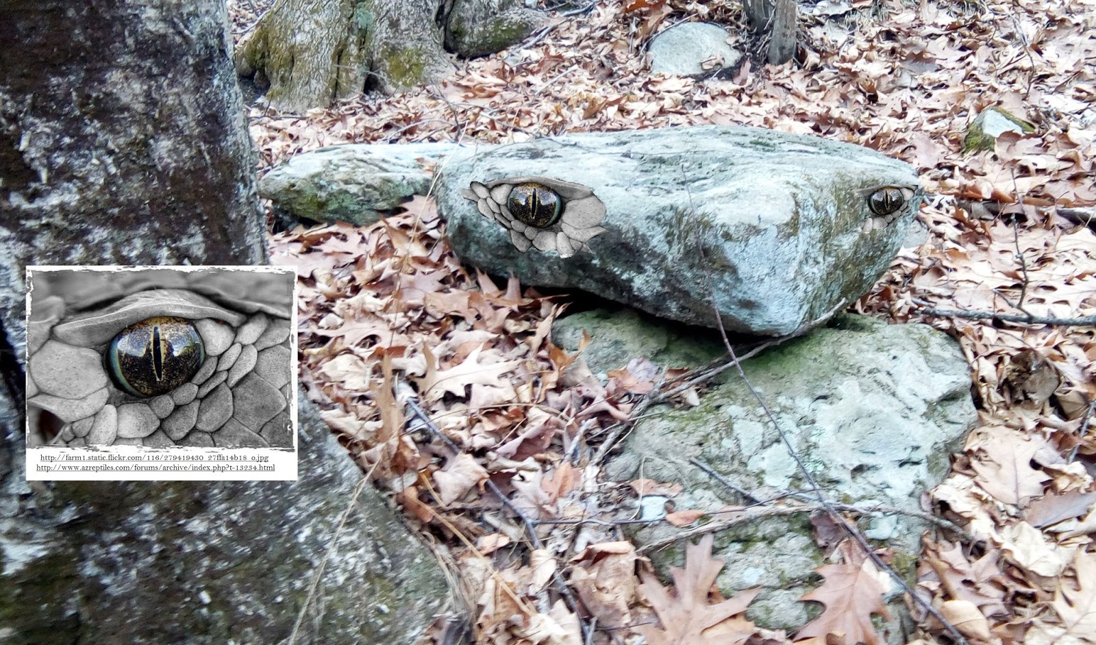
But when you look a little more closely at those boulders, you might notice something else:
Someone at some time just might have modified that boulder so that the boulder appears to have a round white eye. Maybe...

Looking at that stone wall might remind a person of a large snake, similar perhaps to snake petroforms or boulder outlines –or earthen mounds – or even, moving farther south, temples and walls and other structures in Central and South America.
A little imagination (and my Paint program) creates a different view of this gateway:
That’s the “above the ground” clue that hints at Indigenous Culture. Some proper archaeological investigation, below ground, might better assign a date to this gateway. Following the stone walls here leads many interesting places [http://wakinguponturtleisland.blogspot.com/search?q=Preacher].
More Stone Walls on Hillsides (and numerous other places): http://wakinguponturtleisland.blogspot.com/search?q=great+serpent

Visualizing Serpent Walls (with the help of some Abenaki stories:

Wednesday, January 18, 2017

Free Leonard Peltier


Contact the President to grant Leonard Peltier Clemency

Friday, January 13, 2017

Roonie "In the Woods Near You"

Uploaded on May 21, 2011

Roonie finds a mysterious stone enclosure in the woods:


Uploaded on May 14, 2011
Roonie investigates an old stone wall deep in the woods:

Thursday, January 12, 2017

Along an Alertnate Route to Watertown CT


Can you see the Great Snake, the Stone Horned Serpent??


A segment of stone, laid down to resemble a Great Snake, by the "Indian footpath" that became a road named for a pond, shows a boulder head followed by a thick body, with a diamond shaped stone recalls a marking on a rattlesnake and the 7th Scale of the Snake Being called the Uktena, where the heart of the "Strong Looker" can be found, where the Uktens and be wounded and killed. Just behind the head is another stone sometimes found in other Snake Rows of Stones, spanning the width of the "stone wall," a flat surface facing forward, perhaps a place to rest a set of horns on its head..."


"...in Native American myths and legends, horned serpents are usually very supernatural in character-- possessing magical abilities such as shape-shifting, invisibility, or hypnotic powers; bestowing powerful medicine upon humans who defeat them or help them; controlling storms and weather, and so on...horned serpent mythology may trace back to ancestors of Eastern Native American tribes such as the Hopewell, Mississippian, and other mound-builder civilizations, as stylized serpent motifs have been found in their earthworks and artifacts which bear some resemblance to the horned serpents of historical Native American tribes..."


Tuesday, January 10, 2017

NEW ENGLAND MEGALITHS; BIG CREEPY ROCKS IN THE WOODS

     My longtime friend (I don’t call anyone an “old friend” anymore) made me aware of a website I hadn’t taken notice of yet, and I wince at some of what I found there when I clicked on the link and took a look at some “big creepy rocks in the woods.”

     It was very disturbing to come across this: "These are not pictured here, but many burial mounds (I believe) litter the base of the mountain. I have dug a bit into one of these, which was made of small stones and earth, and found a very strange piece which is explored in the next post."
   I can’t find those sentences on the page now, although there is still a photo of the author which will also probably soon disappear on the page (digging at night):


     Another friend writes (and brings up some good points with his comment):
   “Some good pictures on this site. Although, yes, some disturbing things. The header under the blog title reads "Creepy Big Rocks in the Woods." I don't know about "creepy." More like "sacred." Also, he states that American Indian culture is not responsible, that Native people themselves told the colonists that an "older" race built these megaliths. Sorry, but that just isn't true. As Jim Porter points out there is enough evidence once you find the research that points to the mound building/ stone building tradition of Native people in this region. Also, for Native people to tell a colonist that "we didn't build this, it was the old ones" is like being in New York City 200 years in the future from now and asking a New Yorker in the future who built the Empire State building. "It wasn't us," they would say, "the ones that came before us built that." To put that in perspective...he would rather listen to the English researcher Hugh Newman (who I must admit has some good material out with his Megalithomania project- well let's just say the good, the bad and the ugly) instead of finding research that points to more local sources of research, or perhaps he just doesn't know where else to find info. My 2 cents.”
     I only hope that the blog author has learned to immediately cease this digging business. I understand the frustration involved with the recognition of Indigenous features of a Ceremonial Stone Landscape, especially in what is now called New England, as well as a lack of information from an easily accessible reliable on-line source (where pseudoscience dominates and drives a lucrative market P.T. Barnum would be envious of). The federal government acknowledges them and protects them to a degree (although who knows what may happen after the Inauguration), yet the state governments still do not.
   The point is “You cannot un-dig a site any more than you can un-bulldoze a site,” regardless whether you are a well-meaning amateur archaeologist or an oil company employee “just following orders.”
    And you need to be aware about Federal Laws and State Laws before you begin some unauthorized night-time dig in New Hampshire or some Labor Day weekend bulldozing in North Dakota...
   I wondered about New Hampshire Laws and found this:
“How is the excavation of archaeological resources restricted in this state (of NH)?”
Section 155-E:2 Permit Required
A permit is required for any excavation of earth. Such a permit may be waived if the excavation is part of an earlier excavation or if the excavation relates to public highways.
Division of Historical Resources
The New Hampshire Division of Historical Resources issues permits for archaeological projects on state lands or under state waters. It also oversees the treatment of unmarked human burials discovered during land-altering activities.
Section 227-C:7 Permits Issued for State Lands and Waters
The state, acting through the commissioner of the department of cultural resources, reserves to itself the exclusive right and privilege to conduct, or cause to be conducted, field investigations of historic resources that involve the alteration of the surface or subsurface of the resource and removal of any surface or subsurface objects." 
   I could find the Vermont laws and regulations, https://www.wcl.american.edu/burial/vt.cfm, but nothing for any of the other New England states at this site...


Jun 22, 2018 A Somerville man is charged with making threats against a judge and court officers on Facebook. Jordan Kert, 29, smiled at times and made faces during his court appearance on Friday...The charges against him are serious. The Somerville man has a history of allegedly threatening former co-workers on social media. Prosecutors say he used the alias "Bob Daniells" on Facebook 
(And recently he's also assumed this identity:)
Kert is being held pending a "dangerousness" hearing.


2023, Graham Hancock rekindles Kert's Quest for Fame: 


Monday, January 09, 2017

Along Some Snowy Back Roads - Southbury/Roxbury CT


Below: A "stone wall" connecting to the outcrop...


Tracing a the "spine" of a ridge of outcrop: