Tuesday, September 26, 2017

Not So Remote Locations

    Don’t get me wrong. There are spectacular Stone Ceremonial Landscape sites in remote locations all over Turtle Island. But as Diane Dix says, “(T)he lithic remains of the Native Americans of New England remained hidden in plain view for centuries.  Many of these features are constructed with stone and blend quietly and reverently into the natural surroundings. Yet, once one awakens to their presence they seem to be everywhere.”
  And I agree with Diane, these stone features seem to be everywhere, especially once you begin to see the repeated shapes and patterns – and all the variations – everywhere you go. Especially when traveling along New England roads where the older Indigenous Stonework remains relatively undisturbed. I pass by openings in stone walls and suddenly notice wonderful examples of big triangular boulders often on both sides of the entryway that once you look more closely resemble Rattlesnake heads. (Such as these  https://wakinguponturtleisland.blogspot.com/2015/01/another-possible-ophiomorphic-petroform.html or any of these for that matter https://wakinguponturtleisland.blogspot.com/search?q=gateway)


   Just lately, I’ve been looking at other people’s photos on social media noting all the different forms of Manitou Stones, from seeming simple triangles to those “head and shoulders” types as well as everything else in between. I’m not sure who named these stones Manitou Stones and can only vaguely tell you what it symbolizes or means, much like I can only vaguely tell you that Manitou is a kind of an essence of life and spirit contained in everything from stars to stones to animals and people and, well, everything.

    So I went looking at posts from this past April (2017) to find some Manitou Stones I just happened to observe while looking to see if a row of stones behind a local hardware store (I was looking out the window by the paint mixer machine at a “stone wall”), not exactly a remote location but still sort of one considering that not too long ago there were more cows than people populating this particular Connecticut town.
Above: Main Street South
Below: The window circled in red and the approximate location of the "Stone Wall"
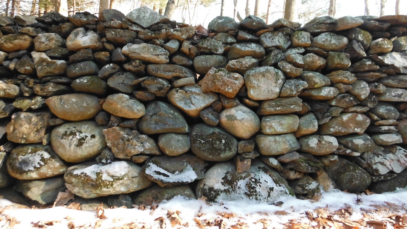
I tried looking at some old 1934 aerial photos to see if the stones showed in that:
I fooled around a while and tried some tricks with Google Earth, looking for the houses that would put things into perspective (putting north at the top too). That's the row of stones circled in yellow:
So here's the beginning of the row, disturbed a bit at the western end:
Following the row:
Noting some small possible Manitou Stones and observing the stack, somewhat reminiscent of certain stone piling in stone mounds:


And the end stone:
Adding the eye: 
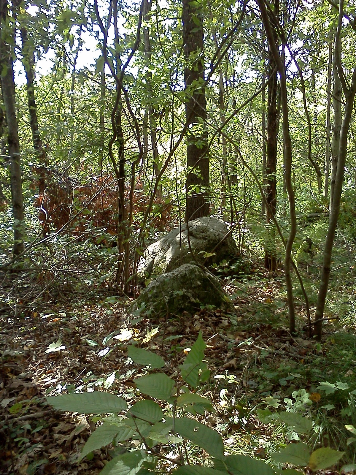
So I turned a little north and west, pondering the boulders I could make out thru the trees:
Closer, photo-bombed by a red dog for perspective:


I couldn't help but notice the sort of rhomboidal shape within the Manitou - and as I looked up there's that sort of sugar loaf shape again in another couple boulders:


It was an eye-opening experience:


Monday, September 25, 2017

First Standing Stone


Above are the two largest Equinox Stones while below is the Solstice Marker, the photos taken from the same place, looking east and north respectively (and respectfully).


    Back in 1990 when I first began to suspect that an Indigenous Cultural Landscape could be found “in plain sight,” as they say, one of the first “notable stones” I came across was a boulder that I suspected marked something, especially when two other boulders and a series of smaller stones connecting them were taken into consideration. 


    Using some Boy Scout skills, backed up by some field observations during several Spring or Vernal Equinox sunsets (the only time the event could be seen through the leafless branches of trees), I also used a compass to complete the triangulation that seemed to suggest that the Summer Solstice sunset was also “marked” by the largest of the three boulders.

Looking back at the Stone (now knocked out of place) that was the "View Stone" from which I conjecture the Solar Events were originally observed to create the Ceremonial Stone Feature, perhaps to "Center One's Self in the Universe."


An old drawing that included the Solstice Standing Stone:
It's also a drawing that was inspired by this illustration from a local history, adding in some stone Burial Mounds that were destroyed/plundered in the mid 1800's:

 I’d have to say that I was influenced by the book Manitou by Mavor and Dix and this illustration:
I recall finding this from Dan Boudillion:
The phrase "Standing Stone" comes up often at the Rock Piles blog, and a search of the site will pull up many examples, including this one:


    Twenty seven years later, I find that I was not too far off base -and that an Indigenous term for this type of Ceremonial Landscape Feature is coming into use:

Above:“Sunśh nipámu - (‘marker stone’ Narragansett, Harris and Robinson 2015:140, viz. sunś, ‘stone,’ nipawu ‘stand up,’ Mohegan Nation 2004:100, 83) serve as indicators...” Rolf Cachat-Schilling (2016) - 

https://vc.bridgew.edu/cgi/viewcontent.cgi?article=1202&context=bmas

Thursday, September 21, 2017

Some Old News I Missed

Native Insight: Ancient ceremonial complexes interesting to the inquisitive mind
By GARY SANDERSON
For The Recorder

Friday, July 21, 2017
A great view of Pioneer Valley from Mount Sugarloaf in South Deerfield. RECORDER STAFF
Ceremonial, spiritual and/or sacred landscape and peculiar stone structures within — all of it buried under forested canopies — all of them are concepts that have gained traction in contemporary anthropological circles.
Such features can potentially mark ancient ceremonial complexes where people gathered for annual open-air rituals, perhaps celebrating the solstice or equinox, maybe spring or fall harvest of fish or nuts or berries or you name it; maybe a burial or crevice from which underground spirits or evil serpents emerge. All of it interesting. Yes, interesting indeed to the inquisitive mind.
Even the likes of Tom Wessels, the well-known, respected author/lecturer on New England stonewalls and forested landscapes, believes that some stonewalls were here before Europeans settlers appeared to set their stakes. Then again, talk to experienced archaeologists as I have, and you’ll find that there are more hits than misses when it comes these curiosities, things like beehives or stone piles or stone rows or rocking stones, buried in the forest, often near the remains of 18th- and 19th-century buildings. Of course, proximity to early dwellings and outbuildings doesn’t necessarily rule out indigenous origin. Often the earliest hilltown farms were built on the footprint of old, seasonal, hunting village sites that were easier to clear than forest. But still, it’s a guessing game when it comes to stone structures, which in no way detracts from the recent fascination among amateur and professional investigators alike.
Which brings us to the fourth annual Pocumtuck Homelands Festival, a Nolumbeka Project brainchild co-sponsored by Turners Falls River Culture, on the shady banks of the Unity Park waterfront in Turners Falls. Buried deep under the Turners Falls dam impoundment are what’s left of the ancient, spiritual fishing falls between Unity Park and Riverside, Gill, just above a radical left-hand turn in the river. There could be no more appropriate Franklin County site for such an event, created to celebrate Native American art, music and culture. This year’s festival is a scant two weeks away, scheduled for Aug. 5 from 10 a.m. to 7 p.m. The crowds for the family affair have grown each year and that trend will likely continue again this year.
A main attraction this year will be Native stone structures and archaeology scholar Tim MacSweeney, creator of the blog “Waking up on Turtle Island,” devoted to Native American ceremonial stone landscapes features and culture. He will be on hand to field questions, evaluate artifacts brought by festival attendees or just to shoot the breeze about deep history of the Northeast.
Last year, it was Mary and James Gage, also well-known, published stone-structure experts. Now MacSweeney. Should be fun.

Bowser Road mastodon excavation

Digging much deeper into the well of time, Dr. Richard Michael Gramly, a paleontologist associated with the Sugarloaf Site — a Paleo archaeological site known in archaeological jargon as the DEDIC Site in Whately — is accepting orders for his new book, “Archaeological Recovery of the Bowser Road Mastodon, Orange County, New York.” It should be fascinating reading, having dug the bones and ivory tools crafted from husks of previous kills at a site in Middletown, N.Y., north and west of New York City.
“The Bowser Road mastodon excavation and subsequent research represents a quantum leap forward and point the way to things to be looked for at each new mastodon find. … It will help set the standard for information possibilities that are new, perhaps even revolutionary,” praises Dr. Russell Judkins in the forward.
With contributions from several experts, Gramly addresses the first Clovis-age mastodon kill and ritual site to be reported for the Americas, contrasting data about bone and ivory artifacts, etc. with records of discovery from Eurasia.
The 365-page study includes nine appendages, nearly 200 color figures, plus tables. The cost is $45 for durable (heavy tab) softcover or $70 for cloth hardcover with dust jacket, plus $8 shipping. All orders can be prepaid to ASAA/Persimmon Press, 455 Stevens St., N. Andover, MA 01845. Books will be shipped in a stout carton by U.S. Postal Service.
I myself have listened to Gramly’s description of what he found at the Orange County, N.Y., site, then his tales over the winter of going through a mass of bones and artifacts collected at the Hiscock Site in western New York and stored in metal lockers at the Buffalo Museum. Mastodons, our ancient elephants, have been extinct in the Americas for at least 12,000 years, but are included in indigenous myth and the archaeological record. The site addressed in the book was uncovered by a farmer digging a bog with a backhoe. Unnerved by the unearthing large bones and later informed by experts that they were those of a mastodon, he stopped digging and eventually put the site up for public auction. Gramly raised the funds needed, became the high bidder and excavated the important site.
Now you can read about the dig and his fascinating observations and hypotheses. I don’t think you’ll be disappointed.
Recorder Sports Editor Gary Sanderson is a senior-active member of the outdoor-writers associations of America and New England. Send your questions, stories about our area to him at: gsanderson@recorder.com.

Wednesday, September 20, 2017

Another Turtle Shell Revelation


     I wrote this a little while back:
     "Sometimes there’s a protruding spike sort of thing on a turtle shell, just as in the image above. This has nagged my thoughts for years (meaning that you don't often see this detail on every box turtle you come across, both in person and in other people's images that I lift and use here on this blog)..."
http://wakinguponturtleisland.blogspot.com/2017/09/note-on-some-turtle-shell-revelations.html
     And just now I took a look at another box turtle photo and said:
          "Oh! There's a little spike at the nuchal notch of this one. "


Tuesday, September 12, 2017

Wooden Fragments

One other thing about this row of stones - there are fragments of wood in it.
I suppose it shows the wall was maintained over time.
I don't know how long or by whom - or what kind of wood, 
but someone sometime used the wood to create a little space to make a little repair (maybe).

Some more: