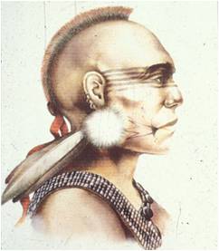
[iii] Lion
Miles (personal communication dated February 7, 2011) cited a deposition of
Capt. Johannis Hogeboom on August 25, 1762: “That he was with Collo. Renselaer
about three weeks ago in company with one Winchel and three Brothers of the
Ferrys[Freese?] at a rock some rod over the Westehook river under a Mountain
where the said Winchel & the Ferris’s swore that there had been there a
Monument or pile of Stones which were all removed”. If the mountain in question
is indeed Monument Mountain, then its stone pile may have been rebuilt by
persons unknown prior to its being vandalized by persons unknown in the early
19
th century – see endnote 108 above.
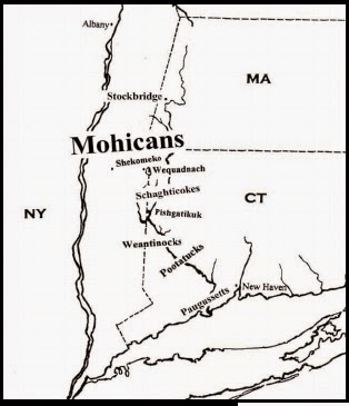
Present Route 7, which runs just east of the
monument, was originally a major Indian trail known as the Old Berkshire Path.
It connected Mohican Stockbridge with the Indian village of Schaghticoke in Kent,
Connecticut, and the more southerly villages of the Weantinock and Pootatuck
tribes in the Lower Housatonic Valley right down to the Paugussett villages along
Long Island Sound.[iii]
The earliest known record of the monument’s
existence is the November 3, 1734 journal entry of the Reverend John Sergeant. The
stone pile was later seen and described by a number of 18th century
Euro-Americans, including the Reverend Ezra Stiles, a scholar and educator who served
as president of Yale University from 1777 until his death in 1795. Stiles
included a hand-drawn map of its location as well as a profile drawing of the
stone monument itself. *
The drawing shows an 18-foot
long stone pile with two six-foot high peaks separated by a concavity.[iii] Ebenezer, John Sergeant’s indigenous
interpreter, told Sergeant that he supposed the stone monument was a gesture of
gratitude to the Creator, “that he had preserved them to see the place again”.[iii]
Other Indigenous
Sacred Sites
Similar stone and “brush” monuments are
located throughout New York and southern New England.[iii] Like the sacred structure at
the foot of Monument Mountain, many were historically documented by 17th
and 18th century Euro-Americans as having been created by the local indigenous
peoples. In most cases, the Native Americans were loathed to explain their
significance to the whites. Explanations were infrequently provided. They
included (1) that the pile marked the grave of a sachem or (2) the location of
an important tribal event; (3) that it was a boundary marker; (4) that a stone
was placed on the pile to bring “blessings” or (5) success in hunting(and if
the ritual were not performed, then the opposite would occur – failure,
misfortune, etc.); or (6) that the stone was a symbol of thanksgiving to the
Creator or some unknown deity.

The Mohican homelands surrounding Monument
Mountain -- Great Barrington, Sheffield, New Marlborough, and adjacent areas --
include a number of archaeology sites dating from just prior to European contact
back thousands of years into the Mohican past.[iii]
The landscape also includes loci with artificially constructed stone piles, sometimes
referred to as “cairns,” and earthen mounds. Concentrations of dozens of these small
stone piles have been identified in Sheffield and in New Marlborough.[iii] None of these stone piles have
historical or archaeological documentation, however, and so there is no definitive
proof yet that they were indeed created by indigenous peoples.[iii]
This is also true for all but possibly one of
the several mound features located in Sheffield, New Marlborough, and Great
Barrington. * As with the stone
piles, none are recorded in the state archaeological site files housed at the Massachusetts
Historical Commission with the exception of the large, flat-topped mound
overlooking the Housatonic River in Great Barrington.
The site is estimated to date from 4,000 to
8,000 years ago, based apparently on an amateur collection of artifacts from
the mound.[iii] Artificial earthen mounds in
northern New England and eastern Canada -- some with stonework, have been
excavated by professional archaeologists and dated to that same time period.[iii]
Native American oral traditions also mention
sacred places in caves, near large boulders and other rock formations, and on
hilltops.[iii] Native American carvings on boulders and rock
outcrops are found throughout New England.[iii]
They likely represent indigenous ritual, as do the rock art of more western
tribes.[iii]
Potentially sacred localities such as caves,
large boulders, hilltops and other rock formations all occur on Monument
Mountain, which also contains some rock carvings that may or may not be of
indigenous origin.[iii] * As
with the “cairns” mentioned previously, above-ground cultural features are
notoriously difficult if not impossible to date, and there are as yet no early
historic records documenting them as Native American. However, as one noted
Massachusetts archaeologist quipped regarding the lack of archaeological
information, “the absence of evidence is not evidence of absence”.[iii] This is also true for the
absence of historical documentation. It is very possible that some or all of
the cultural features discussed were once part of the Mohican sacred landscape.
*
[iii]
Hayden L. Griswold and Matthias Spiess 1930, Map of Connecticut, Circa 1625, Indian Trails, Villages, Sachemdoms,
compiled by Mathias Spiess and drawn by Hayden L. Griswold, C.E. and published
by the Colonial Dames of America Connecticut Society.
[iii] Ezra
Stiles, in the original manuscript of his Itineraries,
op. cit., Volume IV, page 104. Ezra Stiles’ drawing of the monument shows a
large mound 18 feet long and six feet high with a distinctive concavity where
the top of the cone should have been, suggesting that vandals had already been
digging into the mound for “treasures”. It is unclear when Stiles first saw the
stone monument, as the drawing appears in a 57-page booklet labeled “September
18, 1786” that described Stiles itinerary to Albany in that year. In the
booklet he described an October 17, 1786 trip to Stockbridge (Lion Miles,
personal communication to the author dated March 15, 2011). But this was by no
means his first visit to Stockbridge. He
had been a serious contender for the position of Stockbridge minister after the
death of John Sergeant in 1749. Drew reported that in an 1878 letter to the Amenia Times, an N. Reed noted that he
had visited the stone pile on Monument Mountain in 1820 and in 1856, and that
when he returned in 1877 it was “gone”. This story contradicts that of Reverend
Burt, who claimed it had been vandalized a few years prior to 1829. Perhaps the
stone pile had been rebuilt more than once? In 1878 a Berkshire Courier reporter visited the site and noted the center of
the stone pile had been excavated to several feet below the ground surface and
the rocks scattered (Drew, op. cit.)
[iii] Ibid, pg. 41.
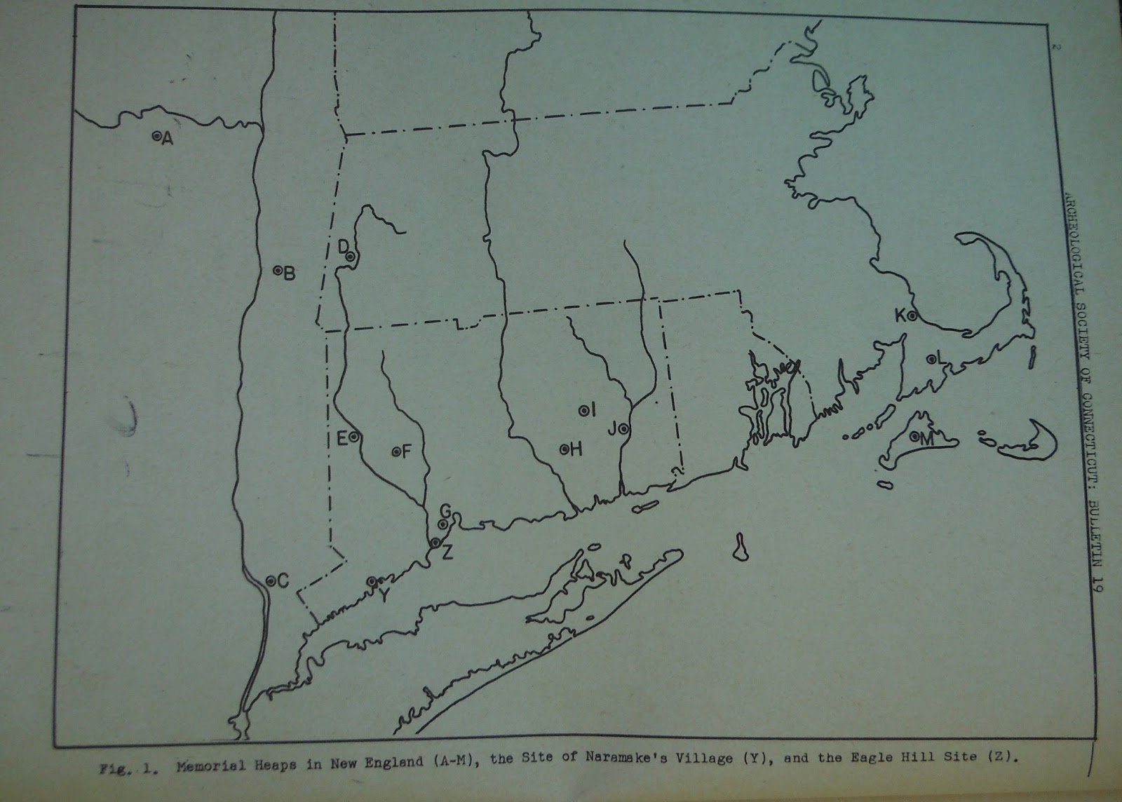
[iii]
Other stone and brush (wood) piles were found throughout Connecticut and eastern New England (For example, see Eva Butler
1946, op. cit.; Constance A. Crosby
1991, “The Algonkin Spiritual Landscape”, pp. 35-41 in Algonkians of New England Past and Present, Peter Benes (ed.),
Amherst: Boston University; Patricia E. Rubertone 2001, pp. 166-167 in Grave Undertakings: An Archaeology of Roger
Williams and the Narragansett Indians, Washington, DC: Smithsonian
Institution Press; William S. Simmons 1986, pp. 252-254 in Spirit of the New England Tribes: Indian History and Folklore,
1620-1984, Hanover, NH: University press of New England; Ezra Stiles 1916, Extracts from the Itineraries and Other
Miscellanies of Ezra Stiles, D.D., LL.D, 1755-1794, with a
selection from his correspondence, Franklin B. Baxter (ed.),New
Haven: Yale University Press).

A stone monument once overlooked the Housatonic
River in the area of New Milford, Connecticut (Butler op. cit. pg. 5). It
supposedly marked the grave of the eminent Weantinock sachem, Waramaug, who
died in 1722. In the early 1800s it was
vandalized by whites; the scattered stones supposedly were used to build a
nearby mansion. Frank Speck reported that the 17th century Mohegans of
southeastern Connecticut built a stone pile above the road leading from Norwich
to Hartford as a boundary marker for the northern extent of their tribal lands;
like the Stockbridge Mohicans did at the Monument Mountain stone pile, Mohegan
members would add a stone to the pile each time they passed. He also reported a
stone pile several feet high on the Schaghticoke Reservation in Kent, on which
early 20th century Schaghticokes still added a stone as they passed
to pay respects to the ghost of a murdered Schaghticoke whom they thought haunted
the area (Frank G. Speck 1945, pp.19, 22 in “The Memorial Brush Heaps in
Delaware and Elsewhere, Bulletin of the Archaeological Society of Delaware,
Vol. 4, No. 2). Stone piles were also found in New York (Butler 1946, op. cit.
pp. 7-8; Dunn 1994:32-33; Miles 2006 op.
cit.; David R. Wagner and David Ostrowski 1997, op. cit.).
[iii] As
shown within individual site forms on file at the Massachusetts Historical
Commission in Boston.
[iii] Lion
G. Miles (personal communications to Lucianne Lavin 2010) has visited such a
cairn concentration in Sheffield, centered about a rock shelter, or overhang,
and a second cairn concentration in New Marlborough. The author has also
visited the latter locality, where cairns are both concentrated and dispersed
over a wide area. They are much smaller versions of the original Monument
Mountain stone pile, with a number of small stones mounded on top of a flat
boulder or bedrock outcrop.
[iii]
According to Lion Miles, there is “some historical documentation on one of the
stone heaps in Sheffield” at the New York Historical Society (Miles personal
communication to the author dated March 4, 2011).
[iii] Massachusetts
Historical Commission site survey form, MHC No. 13-BK-126; the form was
submitted by a member of the Berkshire County Regional Planning Commission. See
also Anonymous 2007, pg. 57 in Great
Barrington Open Space and Recreation Plan, November 2006, Revised July
2007. Photocopy on file at the Stockbridge Mission House, Stockbridge, MA. The
mound is 202 by 200 feet along its base and 14 feet high. The author of the
Great Barrington Open Space and Recreation Plan suggested that the mound was
the locus of the “Great Wigwam”. Stockbridge historian Lion Miles, however,
believes that the historical evidence puts the Great Wigwam near the base of Vossburg
Hill (personal communication dated February 7, 2011).
[iii] Dr.
Frederick Matthew Wiseman described the Middle Archaic L’Anse Amour burial
mound in Labrador, a one meter high and eight meter wide circular tumulus, and
the Middle Archaic Tumulus II, a nine meter wide burial mound at the Bradon
site in Quebec pp. 109-110, in his 2005
book Reclaiming the Ancestors,
Decolonizing a Taken Prehistory of the Far Northeast, Toronto: University
Press of New England. He also discussed the Late Archaic Ketcham’s Island Site
mound in western Vermont, a low earthen mound that was built over the remains
of a five meter wide circular dwelling and a red ochre burial (pg. 146).
[iii] For
example, see Melissa J. Fawcett 1995, pp. 48-53 in The
Lasting of the Mohegans. Part 1, The Story of the Wolf People. Uncasville,
CT: The Mohegan Tribe.
[iii]
Edward Lenik 2002, Picture Rocks: American Indian Rock Art in the Northeast
Woodlands. Lebanon, NH: University Press of New England.
[iii]
Among the Shoshone, the creation of rock art is still a part of tribal puberty
rites.
[iii] Bernard
A. Drew, op. cit.
[iii]
Peter Thornbahn, 1988, discussing the lack of archaeological evidence for
village sites in southern New England, cited by Timothy Binzen 2009, pg. 10 in
“The River beyond the Mountains:; Native American Settlements of the Upper
Housatonic During the Woodland Period, pp.7-17 in Mohican Seminar 2, The Challenge—An Algonquian Peoples Seminar, Shirley W.
Dunn (ed.), New York State Bulletin 506.Albany: University of the State of New
York, New York State Education Department."
Luci's entire article can be found here, quite intact, unlike this post above:
{I used some photos of a few "figures" from Eva Butler from my copy of the above Bulletin, which I finally located, which may be of particular interest to Tommy Hudson. I haven't forgotten, Tom.}