Sunday, December 24, 2006

Mazin's Christmas Reflections

I also recieve regular emails from a Christian Palestinian Peace activist and he just sent me this:

Christmas Reflections/Greeting 2006
http://www.qumsiyeh.org/christmas2006/
by Mazin Qumsiyeh, PhD


"Born in Shepherd's Field near Bethlehem to a Lutheran mother and a Greek Orthodox father, I grew up feeling lucky because we celebrated two Christmases. The Christmas season was a time of family gatherings around kerosene heaters where our fingers were cold but our hearts were warm and stomachs full...

...Since 2002, Bethlehemites have faced the enormous human costs of a massive, concrete segregation wall. During my visit last July, I noticed that the route of the wall zigzagged around Bethlehem, placing fertile Palestinian agricultural lands on the "Israeli side" of the wall. The wall went straight through centuries-old villages - separating Palestinian families from each other and from their jobs, hospitals, schools, churches and mosques..."

Thursday, December 21, 2006

Christmas and New Year’s Greetings


I get emails from Carl Masthay once in a while. Running a Google search about you might find:

“Carl Masthay, PhD (Linguistics), of Polish ancestry from Southington, Connecticut, a Chinese translator in the U.S. Air Force in the early 1960s, and a retired medical manuscript editor at Mosby, Inc., for 33 years, began early study of Algonquian languages stimulated by place-name study culminating in a 47-page monograph on Mahican-language hymns (1980) and 11 years of work on his 200-page Schmick's Mahican Dictionary, published by the American Philosophical Society in 1991 (http://www.puzz.com/kaskaskiadictionary.html).

Here’s just part of what he sent me just this morning:

“To all: A literal tree of Christmas and New Year’s greetings came to me with many errors, which I repaired as well as I could (red). I then added many more that I had been keeping for decades, more from a Web site (georgem@gapent.com) (black for Xmas; weak blue for New Years), more from North American Indians, and about 62 from within the borders of China (New Year’s only)(blue). It is BETTER to leave them in this file because of the special SILDoulos IPA93 font for the Chinese-territory ones. Do what you wish as the years proceed.
Carl Masthay, St. Louis, Missouri, USA, 3 March 2006.”

May there be good wishes to the inhabitants of the whole world.
Also see Merry Christmas (and) Happy New Year per georgem@gapent.com: http://www.etailersdigest.com/resources/christmas.htm combined with http://www.etailersdigest.com/resources/new_year.htm and corrected by Carl Masthay, St. Louis, Missouri, February 2006

Abenaki – Anhaldam mawi kasipalilawalan. (‘Forgive me for any wrong I may have done you.’ The tradition was to go from house to house on New Year's day speaking these words so that the new year can begin with a clean slate. Joseph Bruchac).
Alsacian German (France) – E gueti Wïnâchte (or for children: Chrischtkindelsnocht = Christ-child-little’s-night), un e glecklichs Nej Johr.
Alutiiq (Alaska) – Spraasnikam! [Russian: For the (happy) holidays].
Apache, Western (USA) – Gozhąą Késhmish.
Blackfoot (USA/Canada) – I'taamomahkatoyiiksistsikomi. [Merry big holy day]
Frisian (Netherlands) – Goede Krystdagen. Noflike Krystdagen en in protte Lok en Seine yn it Nije Jier! (‘Pleasant Christmas day and a lot of luck and blessings in the new year!’) Lokkich Nijjie.
Gaelic (Ireland) – Nollaig Shona. Blian Nua Faoi Mhaise Duit.
German – Herztlichste Weihnachtsgrüsse. Frohe Weihnachten! Fröhliche Weihnachten und ein glückliches Neues Jahr! Ein glückliches Neujahr.
Hawai’ian – Mele Kalikimaka ame (or ā me ka ‘and with the’) Hau’oli Makahiki Hou! ’O ke aloha Kalikimaka ia ’oe kekahi e Carl, a pela no ka hau’oli makahiki hou. Christmas greetings to you too, Carl, as well as wishes for a happy New Year.
Hawai’ian (USA) – Mele Kalikimaka ā me (ka) Hau’oli Makahiki hou.

Huron – Jesous ahatonhia. (Jesus is born. = Christmas) –

( Tim’s note: Bruce Cockburn recorded this song, in Hurón, on his “Christmas” CD in 1993 (http://www.brucecockburn.com/xmas.html). He claims in the liner notes that this is the oldest of North American Christmas songs: "Otherwise known as 'The Huron Carol', this is the first Canadian Christmas hymn. It was written early in the 1600s by the Jesuit Fr. Jean de Brebeuf, who acquired fame and martyrdom soon after when he was ceremonially barbecued by members of the Iroquois confederacy, who went on to virtually obliterate the Hurons and their culture. They were encouraged in this by British colonial interests who were after control of French claimed territory, much of which was traditionally Huron. Those of this latter tribe who survived the wars were mostly absorbed into Iroquois communities. A few, however, stayed with the French colonies. Their descendants inhabit a couple of villages in modern Quebec, but their language has largely been lost. Special thanks are due to John Steckley for his help as translator and pronunciation coach."

You can listen to the song, see the lyrics and a translation at: http://firstnationhelp.com/huron.html (with a downloadable MP3 of Native Vocal group))


Italian – Alegre Natal. Buon Natale e Felice Anno Nuovo. Buon Natale e Buon anno nuovo. Felice capo d’anno.
Japanese – Kiristo Kōtansai omedetō. キリスト降诞祭 おめでトう.Yoi Kurisumasu-o Oinori itashimasu. (‘Christ birthday-anniversary congratulations. Sending a respectful prayer for a good Christmas.) Kiristo no tanjōbi omedetō. Meri Kurisumasu. Akemashite omedetō gozaimasu. (‘[new dawn] breaking open polite congratulations’) 謹賀新年 Kinga Shinnen. (‘Respectfully celebrate the New Year.’ 2006 = 平成18年, 元旦 Heisei jūhachi-nen, gantan)
Krio (Gambia) – Cheers dis Krismas Oo!
Lakota (N. Central USA) – Wanikiya tonpi wowiyuskin na Omaka Teca Oiyokipi.
Navajo (Diné) (SE US) – Merry Keshmish. Kasmish Bihozhi. or Yá’át’ééh Kéeshmish. Hozhi Naghai.
Osage (Internet Siouan font) – WahkóNta izhíNke iitáe ékitxaN. ÓweenaNpi. (‘God son he.was.birthed it.is.time.again we.are.grateful.’: ‘It is time again to celebrate Jesus’s birthday.’) OmáiNhka htséka okáshe dhiNké ni-pi-hkóNbra. (‘year new troubles none plural-you I.want’: ‘I want you to be in peace in the new year.’) e as in let; N = nasalized vowel.
Tuscarora – NayeNkwarihwatuk'eNhti ha? thwec'e:haws Y'e:suhs (‘It is holy to us, the birthday of Jesus’: Merry Christmas’). Eθachen'eN:tyeN? ha? awuhst'a:θe:? (‘that it make you happy the new year’) (c = c-háchek, 'e: = high-pitch accented long /e/, eN = nasal vowel, 'eN = high-pitch accented nasal vowel, 'eN: = high-pitch accented long nasal vowel, ? = glottal stop, θ = theta).”

If you’d like a complete copy of the “135-kilobyte e-mail document,” as Carl puts it, I could forward it to you. I find it interesting and sort of amazing.

Peace and Best Wishes to all who read this; my mom suggests that we all celebrate every holiday we can and I invite you to do the same!

Peace,
Tim

Monday, November 27, 2006

Day of...


“The first official "Day of Thanksgiving" was proclaimed in 1637 by Governor Winthrop. He did so to celebrate the safe return of men from Massachusetts who had gone to Mystic, Connecticut to participate in the massacre of over 700 Pequot women, children, and men…”


UAINE and the history of National Day of Mourning: “In 1970, United American Indians of New England declared US Thanksgiving Day a National Day of Mourning. This came about as a result of the suppression of the truth. Wamsutta, an Aquinnah Wampanoag man, had been asked to speak at a fancy Commonwealth of Massachusetts banquet celebrating the 350th anniversary of the landing of the Pilgrims. He agreed. The organizers of the dinner, using as a pretext the need to prepare a press release, asked for a copy of the speech he planned to deliver. He agreed. Within days Wamsutta was told by a representative of the Department of Commerce and Development that he would not be allowed to give the speech. The reason given was due to the fact that, "...the theme of the anniversary celebration is brotherhood and anything inflammatory would have been out of place."
What they were really saying was that in this society, the truth is out of place…”


Accessed Nov. 2006 from: http://www.uaine.org/

Wednesday, November 15, 2006

More Thoughts about "The Map Thing"


Since I just happened on these files from recent years, I thought I'd say a little bit more about maps and what's really on the ground.


I'm not going to tell you exactly where it is.
But it is on a floodplain field.
When English settlers moved here in the late 1600's, they took over and put under cultivation the already cleared fields that stretched for four or five or more miles south of here.
They didn't take over this "meadow" because there were Native People living in the area who were already planting here.

You can't really see some important water features above, except for that thin blue line which is actually a ditch that diverts the stream from where it originally flowed...

So here's the (blurry) aerial photo I got from somewhere sometime of the same place.

And here's my enhancement:

The blue is an intermittent sort of stream. There was a 100-year flood back in August 1997 that "flushed out" this stream. The red lines are a serpentine row of stones and some remnants the flood uncovered. The purple is zigzag stone rows.
The green is apple trees; some are very old, some sprouted from old roots of old ones.
The yellow triangle is a sort of solar calendar that marks the summer solstice and and the two equinoxes.


An old drawing, not very good since it doesn’t show how serpentine the row is, is reproduced below.

Hmmm. I seem to have drawn a mound in there that doesn't exist. Perhaps I was interrupted before I could draw a line from that mound to the "Buried Turtles" spot. My idea was that the farmer who robbed the graves probably found it easy to pile the donation stones in a straight line running north and south as a property fence, to which more modern wire fences have been added. Some of the chestnut posts still remain to today too.

Forever removed also is soild proof that the Burial Grounds ever existed; it's now nothing more than a Grandfather Story, illustrated with an old woodcut in an old history.

Tuesday, November 14, 2006

The Walls and Me

So here’s me, looking at more stone wall information from acceptable scientific sources, the “lunatic fringe” that includes (me and) many friends of mine, and the actual stonework I see on the ground around me. The first group says “There’s little bits of Native American made stone work,” the second group says there is a lot, and the last group is slowly disappearing.
My resume includes years of wandering in the woods, the place I’m most comfortable in this world, as well as living in this old house of ours where I’m even more comfortable.
The occupation I had for the longest time was a Restorer of Antique Furniture - I “peeled back the years” of history to get to the original state of pieces of furniture. I’m applying the same techniques to this home of ours to do the same, keeping in mind that my limited budget allows me to keep intact some historic changes that are part of the house’s history.
This is a long story – I may have to return as a ghost to ever finish the project- and I don’t want to get distracted by going into it too much.
It’s all a part of an ability to see things as they were, a natural talent to which self education eventually added up to some sort of notoriety to be able to be considered quite good.

My wanderings sometimes led to puzzling bits of stonework and I relied a lot on the works of Eric Sloane to explain some puzzles to me. He even had a great explanation for Zigzag stonewalls. It’s the one almost everybody uses as they write about them.
Before I started this blog, I posted that explanation at my friend’s fine blog:
http://rockpiles.blogspot.com/2006/03/sloane-et-al-tell-you-this-is-how.html
But I found another scan from an old floppy disc:


I accepted that explanation for the longest time until I read about Indian Fences here and there, including the first two before coming up with my own idea based on other rows nowhere near vast areas of floodplains where I live, much of it still cornfields and hayfields etc.
http://rockpiles.blogspot.com/2006/03/3-hunting-fences-from-tm.html
I developed a hunger for information and read local and not so local histories and journals and books and eventually found my sister Joan had a book she’d used as a student at UCONN.
http://www.ecobooks.com/books/changes.htm
(Cronon writes):
"What most impressed English visitors was the Indians' burning of extensive sections of the surrounding forest once or twice a year. 'The Salvages,' wrote Thomas Morton, 'are accustomed to set fire of the Country in all places where they come, and to burne it twize a yeare, viz: at the Spring, and the fall of the leafe.'
"Here was the reason that the southern forests were so open and parklike; not because the trees naturally grew thus, but because the Indians preferred them so. As William Wood observed, the fire 'consumes all the underwood and rubbish which otherwise would overgrow the country, making it unpassable, and spoil their much affected hunting.' The result was a forest of large, widely spaced trees, few shrubs, and much grass and herbage. 'In these places where the Indians inhabit,' said Wood, 'there is scarce a bush or bramble or any cumbersome underwood to be seen in the more champion ground.'
"By removing underwood and fallen trees, the Indians reduced the total accumulated fuel at ground level. With only small nonwoody plants to consume, the annual fires moved quickly, burned with relatively low temperatures and soon extinguished themselves. They were more ground fires than forest fires, not usually involving larger trees, and so they rarely grew out of control. Fires of this kind could be used to drive game for hunting, to clear fields for planting, and, on at least one occasion, to fend off European invaders."
Elsewhere in the book, Cronon writes that this is a generalization and that such things are best studied at the local level. “Soon extinguished themselves” was an idea that seemed a little haphazard, and looking at distinct areas never cultivated around where I lived (and those Native People as well) led me to think about control of these fires. You wouldn't want to recklessly burn up everything around you:
http://rockpiles.blogspot.com/2006/03/this-stone-firebreak-wont-burn-tm.html

Some more Cronan:
Changes in the Land: Indians, Colonists, and the Ecology of New England
by William CrononPaperback - 241 pages 1st Ed. edition (June 1984) Hill & Wang Pub; ISBN: 0809001586


http://www.ecobooks.com/books/changes.htm
http://www.rsiss.net/ecology/changesinland.html
http://rvannoy.asp.radford.edu/rvn/680/digests/meller1.htm

From what looks like some sort of homework assignment I found “Things To think About…” where I like the last question best since I’d reply “Look at some stonework that might be ancient.”

http://ocw.mit.edu/NR/rdonlyres/History/21H-421Spring2004/448FF6EE-38BE-4BA2-A242-BEE1553FD2A2/0/cronon_chs_ques.pdf

http://www.nescb.org/epublications/winter2001/salett.html
(and a link to
http://www.massaudubon.org/Nature_Connection/Sanctuaries/Broadmoor/index.php )

http://history.wisc.edu/cronon/Writing.htm

Monday, November 13, 2006

Abandoned Walls

From a simplified classification of Stone Walls, I found this description of ABANDONED (Stone Walls): "More affectionately known as "wild walls," this type is usually fairly old; farmstead walls walls that have since tumbled and become unkempt. 
Very few of these (especially the oddest-shaped constructions) may be pre-European in age.
 Regardless of their original origin, all have since become ruins. Thorson Photo: Abandoned wall in UCONN Forest, Storrs, CT. These are the woodland walls where, if a stone falls down, it's usually left where it fell. They are not taken care of. This makes them no more, and no less, wild than the creatures that live on, below, within, and near them. The fact that they are tumbled doesn't diminish their importance, because they have become part of local ecologic and watershed processes. For clues, look for walls that are: Surrounded by trees Tumbled and damaged, especially along the top. Occupy large land tracts. Covered by lichens and moss. Seldom made of quarried ston(e)." Acessed from WWW, Nov.13, 2006 from: http://www.stonewall.uconn.edu/Conserve3types.htm

Friday, November 10, 2006

Spiderwebs


This is sort of a response to the Rock Piles post of Monday, November 06, 2006 that entitled "The Rock Pile Site Prediction Experiment," as well as a sort of request I keep making of my good friend and fellow "rock guy," that also goes out to those who read our pages here in Cyber Space. I'm always saying "It looks like a Turtle" most often but I also keep asking "What about that stone row behind the mound?"

I'm curious what that's connected to, if it's ancient, if it's Native made, if it makes sense in a sacred landscape, is a remnant of a higher degree of civilization that just doesn't seem to be recognised or accepted.

And of course to admit that I am also guilty of the same charge since I'm the person who just recently wrote this at this blog: "The zigzag rows are disturbed by the road but they continue to the south, concealed by brush. And if I did follow them in the past, I don't remember well enough to tell you where they lead."

And I haven't gone back up to look either.
But I shall, in fact will.
Soon.
Really.


So to start out, I guess I'd have to bring up something from the depths my memory, a sort of uncataloged museum where it's easy to get lost.

Some scientists from somewhere showed some Native American Elders some electron microscope photos and some telescope photos to get their reaction about the similarities between atoms and solar systems and galaxies (or something to that effect - the museum is not well lit either).

The Elders weren't very surprised; in fact they said something like "That's what we've been telling you people for a long time. We're glad you finally see. There may be some hope for you after all."

My friend Wendell Deer With Horns, who has wandered around with me to some of the sites I write about always says (as some archeologist shoots down a theory of mine - or refuses to listen - or accuses me of building all these miles and miles of stone rows and the "stone on stones" and all the other stuff) "They just don't see it's all connected."

I think it's an important perspective - and I'll use a couple spots as examples.
My "discoveries" go back to the burial grounds. Missing mounds now, but woodcuts and an ancient history document them; some of the stones turned into a property type stone fence, with posts and barbwire, running along north/south, probably by survey. But underneath is a serpentine row along where the river used to flow. A 100 yr. flood exposed more of it for a while, both sides of the stream stone lined/defined/managed (I'm not sure what term describes it best). When I followed those stone rows I came to the swamp that drains two different ways, that Tobacco Bear and other stones on stones in it.
I got to The Mound swamp because I followed the stone rows from the power line road, just like I followed many a stream with rows or rows across dry land.
I've got guesses about blueberries around it, fire maintained, stone row protected, but I think the swamp may have been burned too when conditions were dry perhaps, the rectangle that encloses the rows burned at some sort of time interval, the forest lands outside at other times, like the mast forest above my house.
(I should have links all this stuff, but I don't - not sure if I wrote it at my blog or Peter's or at Neara and I'm running over my self imposed time limit so I can really get things done, so I leave it up to your memory or search capabilities until a later date.)
So I wonder if those mounds you (and everyone else) are finding are in some sort of space defined by stone fences, for maintenance purposes, particularly by Native Use of Fire, capitalized because of it's widespread use for a very, very long time on Turtle Island.

And it's sort of part of the Connectedness thing, links to earth and sky and and people and trees and animals and stones and the Great Turtle and the Great Mystery.

So, yes I agree that water is important and is a great clue, but don't forget those stone rows - and what Wendell says about everything being connected.

Friday, October 27, 2006

New Stand Up

I want to post this before I forget; when I started my walk the other day, I came across a stone that someone only recently stood up, along the ATV/dirtbike eroded trail that I was following, way down where the first terrace meets the floodplain...

Three views...

Thursday, October 26, 2006

Blueberries


I was just looking at the photos from the other day and, thinking back, I recall not only how many stone rows have dissappered, but also how the blueberry population has declined, up under those power lines.


Because I once worked in the Blueberrie Barrens of Washington County in Maine one summer many years ago, I knew the Indian custom of burning over fields on a four year cycle still continues up there (or Down East as they say).

Maintainance of the power lines and the access roads in recent years involves chains saws and herbicides that kill the bluberries that grow in the sandy soil and need a nematode that lives in its roots (see links for more detail).
In my imagination, in the years before 1700, going back who knows how far, maybe this was an area of low bush blueberries, maintained by burning over sections every four years, those sections selected and controlled by those zigzag rows of stone...
"Low bush species are fire-tolerant and blueberry production often increases following a forest fire as the plants regenerate rapidly and benefit from removal of competing vegetation. (from: http://en.wikipedia.org/wiki/Blueberry )

The row leads into what is now forest...


Blueberry Links:
http://www.wildblueberries.net/bluehistory.html
http://wildblueberries.maine.edu/TableofContents.htm
http://www.nsac.ns.ca/wildblue/facts/pruning.htm (most often "fire pruning")
http://www.downeastsoilwater.org/blueberry.htm

Wednesday, October 25, 2006

In the Mound Swamp


Headed south, I'm up on more exposed bedrock that's covered in leaves right now...It's marked "boulder" in one drawing and "bedrock outcrop in the other...This is a blurry picture of the stone row labelled "130 degrees magnetic" in the drawing, between the outcrop and where the three rows meet.

Here's the notebook scan and a drawing:

Facing south (180mag), this row ends with a single large stone:

Here's the "End Stone."

Mounds:


Boulder with possible "Mesingwe Face"

The "130" stone row in the distance, a stone pile on a boulder, and the Hunter Spirit Face Boulder in the foreground...

Panorama


The Panorama I couldn't post...

Mound Swamp Part One

Where was I? I was at the entrance to the "mound swamp," right at the big red dot on the map here. Or was I? Was it a swamp a long time ago? Did it become a swamp only when those big black dots that are power lines appeared in the 1930's? I can answer that question without hesitation: I don't know... I do know that yesterday I was standing where the big red dot is, looking easterly, when I took the photo above... This detail of the oldest map (1892, I think) is no help at all; it doesn't really look like the same place at all... No map shows the swamp as a swamp, so it's up to me I guess. This sort of V-shaped swamp is outlined by zigzag stone rows. It is swampy now because of the dirt road that is marked by pencil lines. The zigzag rows are disturbed by the road but they continue to the south, concealed by brush. And if I did follow them in the past, I don't remember well enough to tell you where they lead. I turned left (north) on the present day trail... Zigzag rows along the western border... ...that meet up with that black c-shaped line I've so skillfully added to the black and white copies of the topo-map. Disturbed by the trail, I think they intersected. Wouldn't you? It's an approximation; here's the row that leads to what is now an exposed piece of bedrock (covered in leaves, right now). (I'm "off the trail" now, like Gary Snyder says...) See the biggest tree in the photo? Below it is a disturbed mound along the side of the row, a small red dot on the map copy/drawing. The big stone in the foreground is a point stone of the zigzag that thought at the time was a turtle but editing this in November 2021, I can tell you it's a snake's head... The disturbed pile or stack or something... 
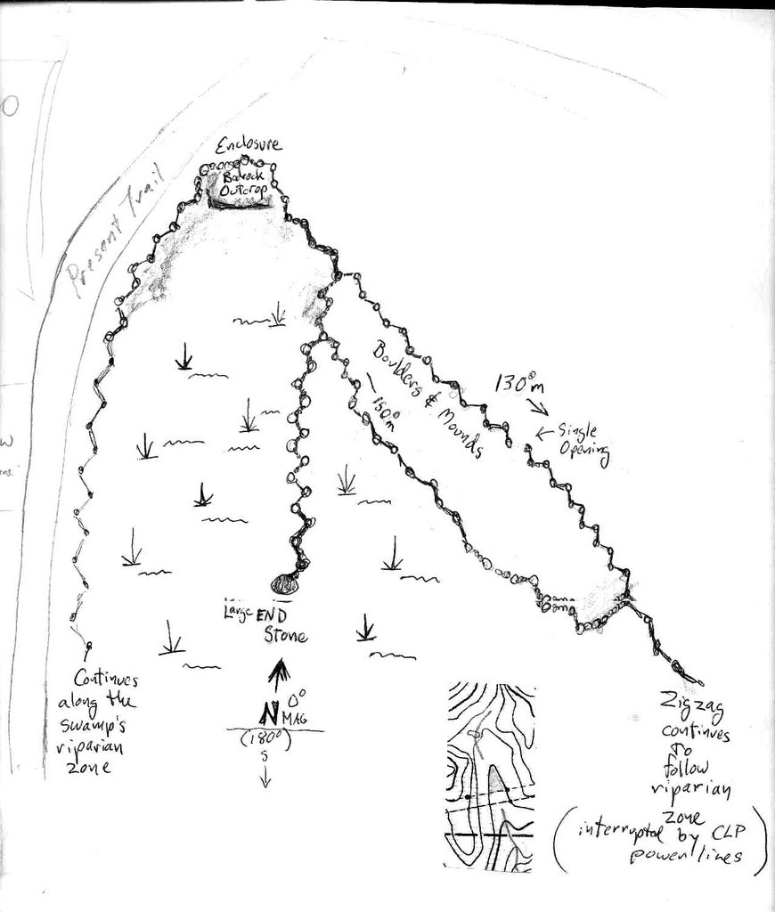
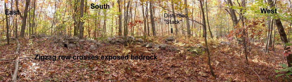
Everybody loves a panorama...except Blogger perhaps; I've tried to upload it 4x now...maybe a separate post will work?????

Tuesday, October 24, 2006

Digital Mound Swamp (Soon Come)


Back in March 2006, I posted some "Mound Swamp" stuff at http://rockpiles.blogspot.com/ that had scanned photos that weren't really great photos. So Iwent back this morning with my beat up old digital camera...


People come from miles around to tear up the landscape, already scarred by the power lines sometime in the 1930's. Where there once was an old tractor path, now there's what looks like a race track...

Many of the old stone rows are missing now. Here's a zigzag remnant that shows nicely, wild low bush blueberries wearing their autumn colors...

My new hat for perspective by some of the stonework. More to follow...

Wednesday, October 11, 2006

More Gary Snyder "Control Burn"


From "Turtle Island"
by Gary Snyder
(1969)


CONTROL BURN

What the Indians
here
used to do, was,
to burn out the brush every year.
in the woods, up the gorges
keeping the oak and pine stands
tall and clear
and kitkitdizzie under them,
never enough fuel there
that a fire could crown
Now, manzanita,
(a fine bush in its right)
crowds up under the new trees
mixed up with the logging slash
and a fire can wipe out all.

Fire is the old story.
I would like,
with a sense of helpful order,
with respect for laws
of nature
to help my land
with a burn, a hot clean
burn
(manzanita seeds will only open
after a fire passes over
or once passed through a bear)

And then it would bemore
like,
when it belonged to the Indians

Before.

You may have seen these before, a few original drawings. How difficult it is to capture the whole network of stone rows that remain, untended for 300 years now, right around where I live - and where you may live too, for that matter - without walking "off the path" in some places, right along it in others...


http://forestry.about.com/od/prescribedfire/ss/pres_fire.htm
http://www.ser.org/iprn/tek.asp
http://publications.theforesttrust.org/download/pdf/DT12.pdf#search=%22controlled%20burn%20%2B%20%22dennis%20martinez%22%22