Saturday, January 31, 2015

Sedentary lifestyle because of overcrowding (CA)

(I imagine it was much the same in New England - with stone snake effigy fuel breaks...)

Native American impacts on fire regimes of the California coastal ranges
     by Jon E. Keeley* US Geological Survey, Western Ecological Research Center, Sequoia-Kings Canyon National Parks, Three Rivers, CA, USA and Department of Organismic Biology, Ecology and Evolution, University of California, Los Angeles, CA, USA

   “Kroeber (1925; p. 601 and 636) described it this way for two tribes in southern California, ‘the Kawaiisu were pressed close against a variety of neighbours [Yauelmani, Yokuts, Tu¨ batulabal, Serrano, Chumash]…. The Juanen˜o Indians … were wedged in between the Gabrielino and the Luisen˜ o’. In fact, some have argued that the sedentary lifestyle of these hunter gatherers was forced upon these peoples because of overcrowding (Cohen, 1981). p306 Journal of Biogeography, 29, 303–320
      How much land area was directly exploited by Native Americans? Kroeber (1962) considered no land was truly ‘uninhabited’, rather lands only varied in the intensity of their utilization, either for subsistence or other ‘customary purpose.’ Intensively utilized portions of the permanent geographical territories averaged approximately 85 km2 (White, 1963). Considering a typical settlement pattern (e.g. Fig. 5), it is apparent that a significant portion of the landscape was potentially influenced by the indigenous populations. This zone of impact would have likely varied dependent upon annual resource availability, expanding greatly during periods of drought (Shipek, 1981). This zone of impact has been described by Anderson et al. (1998) as follows: ‘Every part of the region had long been discovered, walked, or settled by native people by the time Spaniards first landed on the shores of San Diego Bay’. On the surface this may seem to be a bit over-stated, but perhaps not. For example the archaeological record in San Diego County has over 11,000 Indian sites documented, and the widespread dispersion of human activity is illustrated by the fact that these sites occurred within all thirty-two US Geological Survey (USGS) 7.5 min quadrangles studied by Christenson (1990) and on all fifty-nine soil types present within the Kumeyaay (Dieguen˜ o) territory. Christenson’s studies of settlement patterns showed that two-thirds were distributed in the coastal valleys and foothills and the remainder in the mountains. Average elevation was 750 m and 64% of the sites were located in what currently is chaparral or coastal sage scrub vegetation. On average, sites were within 135 m of a water source, although 74% of these are currently seasonal streams.
    Despite the evidence of a dominant presence on the landscape, the rugged terrain throughout the coastal ranges makes it seem likely that there were remote areas left untouched by Native Americans.
Fire as a pre-Columbian land management tool: In contrast to much of the Americas, California Indians had not developed agriculture by the time of the Spanish invasion, which is surprising because such high population density and other cultural advancements are generally associated with agriculture in other parts of the globe (Diamond, 1997). Theories to explain this lack of agricultural development include limited diffusion of ideas/materials and environmental constraints of the Mediterranean climate (Bean & Lawton, 1973). However, it is likely that California Indians were not motivated to develop crops because they were extraordinarily successful at managing the natural resources available (but cf. Cohen, 1981).
    Shipek (1977, 1981) claims that in southern California one of the important cultural resources was a religion that rewarded knowledge on how to increase plant and animal food supplies. Native American’s insight into these relationships is illustrated by their sowing tobacco seeds into post-fire seedbeds (Harrington, 1932). We now know that tobacco (Nicotiana attenuata, N. quadrifolia) germination is dependent upon exposure to smoke or charred wood, as is the case with the majority of chaparral annuals (Keeley & Fotheringham, 2000).
CONCLUSIONS
   Indian burning in the California coastal ranges was not unique as Indians throughout North America used burning for a multitude of land management activities (e.g. Hough, 1926; Barrett, 1981; Pyne, 1982; Wickstrom, 1987; Boyd, 1999; Bonnicksen, 2000; cf. Forman&Russell, 1983).


Let me clarify that comment

 (or at least try)
      Jumping off of the Rock Piles Post Agricultural use versus rock pile site where I left an almost coherent comment (maybe), I attempt to clarify some thoughts below:

     I think that there are some well-known facts that are too often neglected to be taken into perspective when discussing the still remaining Stone Features on the Indigenous Cultural Landscape.
      The first to come to my mind, and perhaps the most important, is the Pre-Contact Indigenous use of fire to produce an abundance of resources. Charles Mann (a map he uses in 1493 above, another below) addresses the issue in a wide view of the western hemisphere in 1491 and William Cronon focuses in on New England in Changes in the Land, not as a simple “slash and burn,” but as a more involved and sophisticated practice, both calling the Indigenous People the keystone species responsible for the creation of a mosaic of resource zones that were wonders to the earliest of Europeans who saw that abundance.
    Some archaeologists and anthropologists call the introduction of maize into New England a “non-event” in an already densely populated area with an already increasing rate sedentism (or semi-sedentism – semi-permanent villages or base camps that People returned to after traveling to outlying sites to “hunt and gather” or collect some sort of resource) because of the efficiency of that sustainable system of manipulating the environment that is poorly described as “hunting and gathering.” Groups of Indigenous People would have to have had an increasingly better means of controlling those fires as populations grew, burning over only certain tracts of land at certain times while leaving others to produce, rather than some sort of widespread and destructive conflagration that neighboring groups of People might not appreciate.

      Cronan suggests that these things are best studied in “locale” and wandering around from floodplain to uplands and beyond in my locale, following zigzag and linear rows of stones along both sides of watercourses was the first place I realized that one function of these constructions seemed to be fuel breaks ensuring that the riparian resource zone would be protected from burning, preserving a green canopy that improves water quality. Another place these double rows of stones occurred was along some trails – especially true of trails that became modern roads, some still with remnants of rows of stones still, many more discernable on CT aerial photos from 1934.
 I can’t think of an easier way to keep a trail clear than to “burn it over" in the fall or the spring – or both. Intersecting these riparian rows and trail rows are other rows of stones, some linear, some zigzag some changing from one to the other, what resource was inside each a puzzle, sometimes with a plant species like blueberries still remaining and growing as clues as to what might have been. The Law of Parsimony works well with this Indigenous Fire Hypothesis, Indigenous People building stone fuel breaks over thousands of years.

      Next to come to mind is the Post Contact business of defining a legal fence in order to claim ownership of land, usually involving the earliest of New England Fences, easily made wooden rail fences. Every single stone wall book or magazine (or web post) article I’ve ever come across drives home the point that earliest of fences were made of wooden rails, the stones haphazardly tossed up against the rails as fields were cleared and plowed (or those prime targets of the early days, the already cleared horticultural fields that Indigenous People had recently vacated). Most insist you had to wait for the American Revolutionary War to be over for a supposed Golden Age of Stonewall Building to begin – and then barely a hundred years later the fun is all over because someone invents barbed wire. Some authors insist these New England stone fences, all the estimated quarter million miles of them, that were too much work for the early European settlers, suddenly appeared between 1783 and an “established Farm Era” that ended about 1825-1835 when people abandoned farms here for more productive land elsewhere or moved to the cities (Thorson), defying the Law of Parsimony once again because: "It's easier to leave a stone wall alone that to build one."


     I think more attention needs to be paid to the manner of construction of those "stone walls" that are too casually dismissed as "agrarian" - in the post contact sense - especially if those "stone walls" end in (or include) a grinning serpent's head like this one above, - and contain stones that are placed to recall turtles (like the one below, just a little south of that grinning serpent - and in a still active agricultural zone) as well as all those bears and birds and rhomboids and much, much more...

Friday, January 30, 2015

Thorson: WHAT GRAMPA DIDN’T TELL YOU

     After reading the something I'd never come across before, entitled "What Grampa Didn't Tell You," all I can say is that I suppose it all depends on which “Grampa” you are listening to. One “Grampa” might just be repeating what others have said over and over, but another “Grandpa” may actually be looking back a little further than 1620 or that Great Age of Stone Wall Building between the American Revolution and the Invention of Barbed Wire and looking a little more closely, wondering, “Who was more likely to include a stone, possibly humanly enhanced, and placed so as to resemble a bear into a stone wall – an Indigenous Person or the later people who have only been here for the last few hundred years?”
    And another Grandpa might say to his 3 or 4 year old grandchild, “Do you see the bear?”
    That innocent little grandchild might point out the bear shape right away (above photo).
    And another Grandpa might look at that possible bear effigy in stone from another angle and ask, “Do you want to see Grandpa turn a bear into a turtle?”
"Come over here, look again and tell me if you see a turtle."

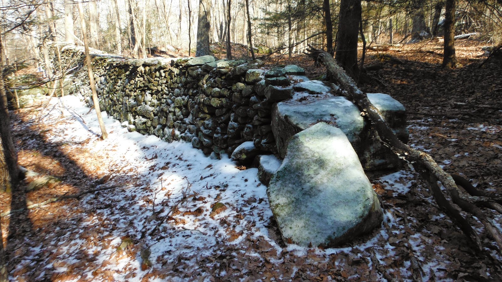
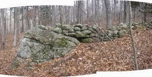
 "Another Grandpa" might take a second look at and start wondering perhaps why the big boulder at the end of a row of stones resembles a snake’s head.
    And how another big boulder at the end of another row of stones resembles another snake’s head – and continues finding that that snake head deal is true of many more rows of stones commonly called stone walls - by almost everybody but Grandpa anyway...
(Grandpa might say: “Stand right here so I can take a picture.” - and then, “Is that a snake?”)
That Other Grandpa might say, “Hey, another Snake with his nose on that other snake!” – and walk with that grandchild along that undulating body, both calling out the shapes in the stones, such as triangles and diamonds, on the lookout for bears and turtles…
     And when it’s just too far for 4 year old legs to travel, "Another Grandpa" might carry the kid along the other side of that “another snake,” back along the far end of that first snake to another gate, stop to take another picture, saying, "Stand on that Snake Head!" before going back to the parked car…

      This is the bit of Thorson I came across that started this line of thought:
“The letter from the stonemason asks Grandpa to sell his walls. Adam doesn’t see the problem until after his tour.” – Above: FRONTISPIECE TEXT (Boulders with Grass)
 “In the very last scene of Stone Wall Secrets,” writes Professor Thorson, “Adam reads the stonemason’s letter, folds it thoughtfully, and then pushes it deep into his pocket. Only several hours earlier he had been joyously riding his bicycle, innocent of the dilemma he was about to face.
Between these two scenes, Adam’s worldview had been transformed. He now understands that their New England family farm was a place where human history merges seamlessly backwards into natural history. He also understands that their “… small corner of the earth…” is a place where past and future environmental choices — including the seemingly benign one he is about to make — always involve a tradeoff between short-term monetary benefits and more lasting, intangible ones. Our beginning and ending scenes with the stonemason’s letter also signify the transfer of knowledge and decision-making authority from one generation to the other, in this case, from a biological family to one formed by adoption. How could a child’s world-view be transformed so significantly in so little time?
The answer is that Grampa — the archetype teacher — had planned this learning opportunity well. Their pleasant afternoon sojourn, although ostensibly about repairing stone walls, was actually a carefully scripted outdoor lesson targeted at a child of just the right age. Grampa’s strategy was to physically guide the boy along a path where accidental discoveries would present themselves; to ask gently probing, open-ended questions about each discovery; to confirm and reinforce the boy’s tentative answers with solid facts; and most importantly, to help launch the boy’s imagination into ancient worlds that are just as real as those of today. In other words, Grampa was teaching the boy to wonder, as well as to learn.
As you — the grandparent, parent, mentor, librarian, camp counselor, teacher or administrator — begin to think of ways to incorporate Stone Wall Secrets into your own learning opportunities, you might wish that you also had Grampa’s wisdom and expertise on these subjects. Don’t despair. Consider that he is right here with you, sharing what he knows not in words, but with this easy-to-use reference. So, who is Grampa, anyway? To begin with, Grampa is a scientist who understands how New England was stitched together geologically and how the farm’s combination of rocks, soils, and climate work together as an integrated physical system of hills, valleys, ponds, and streams; his view of the landscape is that of a skilled, and disciplined observer, one in full possession of the facts at hand. Grampa is also a teacher who knows how to entice children into learning situations, and when to strike them with just the right question; his view of his grandson is that of an eager “sponge” ready to absorb the important lessons of life, but needing help along the way. Finally, Grampa is a sensitive person who understands that important lessons must be experienced emotionally; his view of the world is one in which all humans, all animals, all physical processes, and all academic disciplines are unified by their common origin at the beginning of earth history.
You, the leader of children, must now take over where Grampa left off…”
Scattered throughout New England [1] there are thousands [2] of stone walls [3] crisscrossing woods and fields [4] as if they have been there forever [5]. Each one has a story to tell, a story of farmers and oxen and hard, muddy work. And every stone in every wall also has a story to tell, an older story [6] of the land itself, of mountains and glaciers, of soils and seas.
1 STONE WALLS – Geography – Where are stone walls found? The geographic distribution of stone walls is quite uneven throughout the region. Walls exist wherever the soils of pastures and cultivated fields held a concentration of glacial stones. Areas that were never farmed, or areas where the stones were buried by mud from rivers, lakes, and the ocean have no stone walls, or have them only in unusual circumstances.
2 STONE WALLS – Abundance – How many are there in New England? There are tens of thousands, perhaps even hundreds of thousands of stone walls. Counting them is impossible, and the number keeps changing, as new walls are built, and as old ones disappear. But there are certainly a lot of them. Based on results from a questionnaire published by the U.S. Commissioner of Agriculture in 1871, there are 240,000 miles of stone walls in New England if the terrain east of the Hudson River is included. There are so many walls that it is difficult to avoid them.
3 STONE WALLS – Definition – What is a wall? What do they look like? A stone wall is any elongate row or stack of stones that was (or is) used to partition the landscape. Most of them are crudely stacked, reach just above the knee, and are held together without mortar. Some are little more than heaps of stone, whereas others are intricately laid, with the pieces carefully fit together.
4 STONE WALLS – Pattern – Do they really “criss-cross”? The word “crisscrossing” is not merely a figure of speech; it is literally accurate. Most stone walls bordered property or agricultural fields that were straight-sided, and which intersected each other in a criss-cross pattern, in some places like that of the game tic-tac-toe.
5 STONE WALLS- Abandoned- Why are they found in the woods? Walls that criss-cross the forest were once fields that have now become overgrown with forest, the so-called “secondary” forest of New England. Walls that still criss-cross agricultural fields are merely those that have been kept free of trees, most often because the land is still used for agriculture.
6 STONE WALLS – Antiquity – How old are they? Here we refer to the geologic story of the rocks in the walls, not the wall itself. The earliest walls that can be authenticated are those of the first English colonists and probably date from shortly after the arrival of the Pilgrims on the Mayflower in 1620. Undoubtedly, a few rare stone structures were built by Native Americans prior to colonization, but none are the conventional elongate stack of stones bordering an enclosure or serving as a foundation for a wooden structure.

And going back to my thoughts again: "Another Grandpa" might recently find himself wondering, “Could all those “old stone walls” be Ophiomorphic Petroforms?” Ophiomorphic means " snakelike in form, or resembling the form of a snake." Wikipedia believes that:
"Petroforms, also known as boulder outlines or boulder mosaics, are human-made shapes and patterns made by lining up large rocks on the open ground, often on quite level areas. Petroforms in North America were originally made by various Indian tribes, who used various terms to describe them."


They seem to share characteristics with these acquired from out there on the world wide internet:


Update: One of these snakes at Bannock Point has been "rebuilt," you could say, although "vandalized" is probably a better way to describe it:


Wednesday, January 28, 2015

Revisit Before the Big Snow


Above: A gateway I suspect to be representations of a (or the) Great Serpent - or if you like, "Ophiomorphic Petroforms.”
I did return to the place in Washington CT, just before the big snow storm, but encountered some ice on the structure and along the paths:


Another detail, hard to see in the photo below, was that a stone in the "wall" protruded out into the split in the bedrock, while in another split of another protrusion along that piece of bedrock had a very rounded stone placed in that split. I wonder if these are possible serpent heads as well...