Saturday, December 31, 2011

"That Stone Sweat Lodge Would Make a Nice Pig Pen"

“they have neither the tooles, nor skill, nor heart to fence their grounds (p. 95)."
Letter from Eliot to Whitfield, April 18, 1650; Indians of the Nipmuck Country in Southern New England 1630-1750 By Dennis A. Connole

    My take on this is that John Eliot was encouraging Indians to turn existing stone rows into the legal fences defined by the early colonists that justified and signified ownership of land, improved the land in the eyes of English Law. The multi-purpose stone rows that were created by Indians were not only practical devices for land management of resource zones but also contained elements of Ceremonialism, a sacredness and spirituality shown by the careful and artistic placement of the stones, the shapes of the rows themselves, Great Serpent Effigies, sort of as if the whole Ethnographic Cultural Landscape was a big piece of religious architecture, protected by the spirit beings.
    The tooles were the metal axes and wedges used to split rails, I'm guessing, the skills the ability to make "cross and rail" fences and the heart similar to a response to the suggestion that your combination open air stonework cathedral and fire tended rock gardens would make a good enclosures for livestock...
   
Or perhaps:
 "That stone sweat lodge would make a great pigpen."

            I can see how the suggestion would be met with little enthusiasm.
(I added the above Killingworth CT "Pig Pen" photos on April 22, 2019,
the Cross and Rail on Jan. 23, 2020.)

Added 11/10/2020

“Hassanamesit Woods is now a tract of land set aside for hiking trails and outdoor education; however it was once part of a large 10,000 acre area of land inhabited by the Hassanamisco band of Nipmuc. In 1654, “Hassanamesit” or “land of the small stones” (Dough ton 1997) became the third of several praying towns founded by John Eliot to propagate the gospel…

These families were expected to embrace English styles of land ownership in severalty, and “improve” their parcels in such a way that was satisfactory to the Trustees by clearing, fencing, or altering the natural landscape…

map?

Also in 1729, John Hazelton of Sutton agreed to lease 2 meadows that belonged to Sarah and Peter. He paid the Trustees, “for the use of the said Peter and his Squaw Twenty Shillings per Annum for four years” (Earle Papers: Octavo Vol. 1) under the terms that the Trustees would make allowances should Peter care to “improve any part of the grass for his own use” (Earle Papers: Octavo Vol. 1). This agreement, like many others made at the same time with other Native proprietors at Hassanamesit, included the installation of a “good four rail fence” which, at the end of the four-year term, would be left in good condition for the future use of the owner. Interestingly, the same John Hazelton proposed a similar deal with Christian Misco for the use of her meadow and orchard yard. He proposed to fence the area, care for the apple trees, and yield to Misco’s right to any apples, “as she shall have occasion to use for her own eating” (Earle Papers: Octavo Vol. 1)…


http://www.fiskecenter.umb.edu/Hassamenesit%20Web/Site%20History%20for%20Webpage.pdf


Friday, December 30, 2011

Smith in NE 1615/There never was a Nipmuc tribe as such

Captain John Smith in NE 1615


“That part wee call New England…but that parte this discourse speaketh of, stretcheth but from Pennobscot to Cape Cod…Southward along the Coast and the Riuers we found Mecadacut, Segocket, Pemmaquid, Nusconcus, Kenebeck, Sagadakock, and Aumonghcawgen; And to those Countries belong the people of Segotago, Paghhuntanuck, Pocopasmm, Taughtanakagnet, Warbigganus, Nassaque, Mashcrosqueck, Wawrigweck, Moshoquen, Wakeogo, Pasharanack, 8tc. To these are allied the Countries of Aucocisco, Accominticus, Passataquack, Aggmoom, and Naemkeck: all these, I could perceiue, differ little in language, fashion, or gouernment: though most be Lords of themselues, yet they hold the Bashabes of Pennobscot, the chiefe and greatest amongst them.

The next I can remember by name are Mattahunts; two pleasant lles of groues, gardens and corne fields a league in the Sea from the Mayne. Then Totant, Massachuset, Pocapawmet, Quonahassit, Sagoquas, Nahapassumkeck, Topeent, Seccasaw, Tothtet, JSasnocomacak,. Accomack, Chawum; Then Cape Cod by which is Pawmet and the He Nawset of the language, and alliance of them of Chawum: The others are called Massachusets; of another language, humor and condition: For their trade and marchandize; to each of their habitations they haue diuerse Townes and people belonging; and by their relations and descriptions, more then 20 seuerall Habitations and Riuers that stretch themselues farre vp into the Countrey, euen to the borders of diuerse great Lakes, where they kill and take most of their Bevers and Otters. From Pennobscot to Sagadahock this Coast is all Mountainous and lles of huge Rocks, but ouergrowen with all sorts of excellent good woodes for building houses, boats, barks or shippes; with an incredible abundance of most sorts of fish, much fowle, and sundry sorts of good fruites for mans vse…Betwixt Sagadahock and Sowocatuck there is but The milium or two or three sandy Bayes, but betwixt that and wyieCape Cod very many: especialy the Coast of the Massachusets is so indifferently mixed with high clayie or sandy cliffes in one place, and then tracts of large long ledges of diuers sorts, and quarries of stones in other places so strangely diuided with trincturetl veines of diuers colours: aSj Free stone for building. Slate for tiling, smooth stone to make Fornaces and Forges for glasse or iron, and iron ore sufficient, conueniently to melt in them: but the most part so resembleth the Coast of Deuonshire, I thinke most of the cliffes would make such limestone: If they be not of these qualities, they are so like, the)' may deceiue a better iudgement then mine; all which are so neere adioyning to those other aduanlages I obserued in these parts, that if the Ore proiie as good iron and steele in those parts, as-1 know it is within the bounds of the Countrey, I dare engage my head (hauing but men skilfull to worke the simples there growing) to haue all things belonging to the building the rigging of ship pes of any proportion, and good marchandize for the fraught, within a square of 10 or 14 leagues: and were it for a good'rewar.de, I would not feare to procure it in a lesse limitation.

And surely by reason of those sandy cliffes and cliffs of rocks, both which we saw so planted with Gardens and Corne fields, and so well inhabited with a goodly, strong and well proportioned people, besides the greatnesse of the Timber growing on them, the greatnesse of the fish and moderate temper of the ayre…”

http://books.google.com/books?id=n8A8AAAAIAAJ&dq=%22so%20planted%20with%20Gardens%20and%20Corne%20fields%22&pg=PA422#v=onepage&q=%22so%20planted%20with%20Gardens%20and%20Corne%20fields%22&f=false

A Nipmuc History:

[Note: This is a single part of what will be, by my classification, about 240 compact tribal histories (contact to 1900). It is limited to the lower 48 states of the U.S. but also includes those First Nations from Canada and Mexico that had important roles (Huron, Micmac, Assiniboine, etc.).


Feel free to comment or suggest corrections via e-mail. Working together we can end some of the historical misinformation about Native Americans. You will find the ego at this end to be of standard size. Thanks for stopping by. I look forward to your comments...Lee Sultzman]

There never was a Nipmuc tribe as such. Nipmuc is a geographical classification given to the native peoples who lived in central Massachusetts and the adjoining parts of southern New England. They lived in independent bands and villages, some of which at different times were allied with, or subject to, the powerful native confederacies which surrounded them. Massomuck, Monashackotoog, and Quinnebaug were Nipmuck, but they were subject to the Pequot before 1637. In like manner, the Nashaway at one time belonged to the Sokoni and Pennacook, while Squawkeag was originally part of the Pocumtuc.

Villages: Accomemeck (Acoomemeck), Assabet, Attawaugan, Boggistowe, Chabanakonkomun, Cochhituate, Cocatoonemaug, Coweset (see Narragansett), Escoheag (Eascoheage, Easterig), Hadley Indians, Manchaug (Monuhchogok) (see Pequot), Mashapaug (see Massachuset), Massomuck (Wabaquasset, Wappaquasset, Wabiquisset) (see Pequot) (subject to Mohegan after 1637), Medfield, Menemesseg, Metewemesick, Missogkonnog, Monashackotoog (Monoshantuxet) (see Pequot), Musketaquid, Nashua (Nashaway) (see Sokoni and Pennacook), Naukeag, Nichewaug, Nipnet, Pascoag (Paskhoage), Pegan (Piegan), Poniken (Ponnakin), Quaddick, Quahmsit, Quinebaug (Quinnebaug, Quinapeake) (see Pequot), Quinsigamond, Segreganset, Segunesit, Squawkeag (Squaeg) (see Pocumtook), Tatumasket, Totapoag, Wenimesset, Woruntuck, Wunnashowatuckoog (see Pequot), and Wusquowhanaukit.

Praying Indian Villages 1674:Chachaubunkkakowok (Chaubunagungamaug), Hassanamesit, Magunkaquog (Makunkokoag, Magunkook), Manchaug (Monuhchogok), Manexit (Maanexit, Mayanexit, Fabyan), Massomuck (Wabaquasset, Wappaquasset, Wabiquisset) (also Pequot), Nashoba (Nashobah), Okommakamesit (Ockoogameset), Pakachoog (Packachaug), Quabaug (Quaboag), Quantisset (Quinetusset), Wacuntug (Wacuntuc, Wacumtaug), and Washacum.

Praying Indian Villages 1680: Chachaubunkkakowok (Chaubunagungamaug), Hassanamisco, Magunkaquog (Makunkokoag, Magunkook), Manchaug, Manexit (Maanexit, Mayanexit, Fabyan), Massomuck (Wabaquasset, Wabiquisset), Nashobah, Nashaway (Weshacum), Okommakamesit (Ockoogameset), Pakachoog (Packachaug), Quabaug (Quaboag), Quantisset (Quinetusset), Wacuntug (Wacuntuc, Wacumtaug), and Wamesit. There was also small reservation at Hassanamesit.

http://www.dickshovel.com/nipmuc.html


Thursday, December 29, 2011

Native American Turtle Mythology

"Turtles play positive roles in the folklore of many Native American tribes. In the creation myths of some East Coast tribes (such as the Iroquois and Lenape), the Great Spirit created their homeland by placing earth on the back of a giant turtle. This is why some contemporary Native Americans refer to North America as "Turtle Island." In Plains Indian tribes, turtles are associated with long life, protection, and fertility. In some Plains tribes, a newborn girl's umbilical cord was sewn into a figure in the shape of a turtle to ensure her health and safety. In other tribes, turtles are associated with healing, wisdom, and spirituality.
 
Turtles are also used as clan animals in some Native American cultures. Tribes with Turtle Clans include the Chippewa (whose Turtle Clan and its totem are called Mikinaak,) the Menominee (whose Mud Turtle Clan is named Maehkaenah,) the Huron-Wyandot (who at one point had four different turtle clans: mud turtle, water turtle, striped turtle, and great turtle,) and the Abenaki, Shawnee, and Iroquois tribes. The turtle was also the special tribal emblem of the Lenape Delawares, who have a Turtle Dance among their tribal dance traditions."
A collection of Turtle Stories here: http://www.native-languages.org/legends-turtle.htm

Wednesday, December 28, 2011

Ceremonial Landscape


Two aerial photographs [ top left and right] of the changing geographical context at Rancho Los Alamitos taken a half century apart, from expansive farm lands to suburban subdivision— is eminently clear. This dramatic change to the property’s context will have an effect on future planning and treatment recommendations. (Rancho Los Alamitos Foundation)

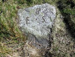
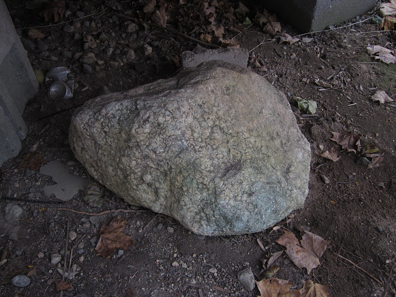
When archaeologists can’t quite understand something they (or somebody else) has found, it becomes “Ceremonial,” regardless of whether or not that “Ceremony” might be known. The only result I got looking for a definition of Ceremonial Landscape this morning is:

Ceremonial Stone Landscape from Wikipedia, the free encyclopedia:

"Ceremonial Stone Landscapes is the term used by USET, United Southern and Eastern Tribes, Inc.[1], a non-profit, inter-tribal organization of American Indians, for certain stone work sites in eastern North America. Elements often found at these sites include dry stone walls, rock piles (sometimes referred to as cairns), stone chambers, unusually-shaped boulders, split boulders with stones inserted in the split, and boulders propped up off the ground with smaller rocks. While neither the age of these sites nor the idea of their creation by indigenous peoples has been accepted generally, interest in the sites is increasing. This interest is generated in part by USET's Resolution #2007:037 [2], entitled Sacred Ceremonial Stone Landscapes Found in the Ancestral Territories of United Southern and Eastern Tribes, Inc. Member Tribes.”

http://dictionary.sensagent.com/ceremonial+stone+landscape/en-en/


Easier to find is the definition of Cultural Landscapes:

“Cultural Landscapes have been defined by the World Heritage Committee as distinct geographical areas or properties uniquely "..represent[ing] the combined work of nature and of man..".[2]

The World Heritage Committee has identified and adopted three categories of cultural landscape, ranging from (i) those landscapes most deliberately 'shaped' by people, through (ii) full range of 'combined' works, to (iii) those least evidently 'shaped' by people (yet highly valued). The three categories extracted from the Committee's Operational Guidelines, are as follows[3]:

(i) "a landscape designed and created intentionally by man"; (like Central Park in NYC or your local Walmart)

(ii) an "organically evolved landscape" which may be a "relict (or fossil) landscape" or a "continuing landscape";

(iii) an "associative cultural landscape" which may be valued because of the "religious, artistic or cultural associations of the natural element"

http://en.wikipedia.org/wiki/Cultural_landscape


So I guess what I really spent a lot of time looking at and wondering about is an “associative cultural landscape” or at least the remains of one type of Associated Cultural Landscape called an Ethnographic Landscape (a landscape containing a variety of natural and cultural resources that associated people define as heritage resources. Examples are contemporary settlements, religious sacred sites and massive geological structures. Small plant communities, animals, subsistence and ceremonial grounds are often components.) sticking out of the layers of successive cultural landscapes that sort of surround it or have made use of it in some instances, as in the case of “stone walls.”

So here is what the World Heritage Committee has to say:

"The Associative Cultural Landscape is a type that is linked to cultural traditions. The inclusion of such landscapes on the World Heritage List is justifiable by virtue of the powerful religious, artistic or cultural associations of the natural element rather than material cultural evidence, which may be insignificant or even absent. The associative cultural landscape is the physical place where intangible aspects of cultural heritage are embodied.

Examples of each type of cultural landscape are inscribed on the World Heritage List. Since 1992, with the acceptance of these definitions and the ability to inscribe cultural landscapes, there have been 60 cultural landscapes of outstanding universal value to all of humanity inscribed as a shared global heritage. Cultural landscapes are places of heritage value. Geologically diverse cultural landscapes are a rich array of local, regional and global heritage resources. For example:

• Sacred groves in Ghana that foster traditional medicine and preserve biodiversity date to early peoples

• Seashore villages that express the interdependence of the sea and the community in ways of life, craft, work, settlement pattern, land uses and scale example—Norway? Nova Scotia

• Egyptian and Chinese tomb site planning, layout , earth forms and structures are ancient designed landscape

• Modern gardens of globally important landscape architect Roberto Burle Marx date to the twentieth century

• The sacred mountain of the New Zealand Maori peoples is associated with spiritual beliefs"

http://www.iflaclc.org/definitions.html

Detailed Documentation of a Cultural Landscape

A single landscape architect may begin with a specific historic landscape for a preservation project or in response to a threat. The completion of a detailed inventory form may follow the international form prepared by the ICOMOS IFLA International Scientific Committee on Cultural Landscapes (see right). There are also inventory forms from several countries that may be of use for inventory planning (see right). The location, name and history of the landscape are gathered along with details of the existing conditions, ownership, access and legal protection.

The historic character of the landscape, and the degree to which that character is evident today, guides the research and documentation of the inventory, and contributes to assessment and planning for the future. In developing an inventory we seek to perceive and document the full range of resources that comprise the landscape. A useful approach is to follow a comprehensive landscape character-defining features check list as a guide.

This list directs attention to each aspect of the physical landscape:

• Land Uses, Patterns, Clusters

• Natural Systems

• Spatial Organization

• Visual Relationships

• Topography, Surface Drainage

• Vegetation

• Circulation Systems

• Water Features, Natural and Constructed

• Non-Habitable Landscape Structures and Buildings

• Spatial Character of Habitable Structures

• Vocabulary of Site Furnishings and Objects

The tangible, character-defining features of the landscape, noted in this listing, should be explored in the archival research, historic period narratives, fieldwork addressing existing conditions, and exploration and selection of preservation interventions. Rediscovering, in detail, the historic character of the landscape guides the consideration of the future.

The intangible values and meanings of a cultural landscape should also be documented and understood. These values may include:

• Location for festivals

• Setting for traditional music, dance, performance

• Route of pilgrimage

• Setting for worship

• Place of memory of past events

• Place of traditional practices

• Gathering place for native plants

• Gathering place for craft materials

• Traditional place for experience at a special time of year

http://www.iflaclc.org/inventory/documentation.html


In the USA, here is a link to “the” guidelines, prefaced by this little bit:

Cultural landscapes are composed of a collection of features which are organized in space. They include small-scale features such as individual fountains or statuary, as well as patterns of fields and forest which define the spatial character of the landscape.

Individual features in the landscape should never be viewed in isolation, but in relationship to the landscape as a whole. Each situation may vary, and some features may often be more important than others. For example, circulation (roads, parkways, drives, trails, walks, paths, parking areas, and canals) may be an important historic element in one landscape, while in another it may have little if any significance.

Overall, it is the arrangement and the interrelationship of these character-defining features as they existed during the period of significance that is most critical to consider prior to treatment. As such, landscape features should always be assessed as they relate to the property as a whole. Thus, spatial organization and land patterns are always listed first in each section of the Guidelines.

Organizational Elements of the Landscape


Spatial Organization and Land Patterns refers to the three-dimensional organization and patterns of spaces in a landscape, like the arrangement of rooms in a house. Spatial organization is created by the landscape’s cultural and natural features. Some form visual links or barriers (such as fences and hedgerows); others create spaces and visual connections in the landscape (such as topography and open water). The organization of such features defines and creates spaces in the landscape and often is closely related to land use. Both the functional and visual relationship between spaces is integral to the historic character of a property. In addition, it is important to recognize that spatial relationships may change over time due to a variety of factors, including: environmental impacts (e.g. drought, flood), plant growth and succession, and changes in land use or technology.


Character-Defining Features of the Landscape

There are many character-defining features that collectively contribute to the historic character of a cultural landscape. These are as follows:


Topography, the shape of the ground plane and its height or depth, is a character-defining feature of the landscape. Topography may occur naturally or as a result of human manipulation. For example, topographic features may contribute to the creation of outdoor spaces, serve a functional purpose, or provide visual interest.


Vegetation features may be individual plants, as in the case of a specimen tree, or groups of plants such as a hedge, allee, agricultural field, planting bed, or a naturally-occurring plant community or habitat. Vegetation includes evergreen or deciduous trees, shrubs, and ground covers, and both woody and herbaceous plants. Vegetation may derive its significance from historical associations, horticultural or genetic value, or aesthetic or functional qualities. It is a primary dynamic component of the landscape’s character; therefore, the treatment of cultural landscapes must recognize the continual process of germination, growth, seasonal change, aging, decay, and death of plants. The character of individual plants is derived from habit, form, color, texture, bloom, fruit, fragrance, scale and context.


Circulation features may include, roads, parkways, drives, trails, walks, paths, parking areas, and canals. Such features may occur individually or be linked to form networks or systems. The character of circulation features is defined by factors such as alignment, width, surface and edge treatment, grade, materials, and infrastructure.


Water features may be aesthetic as well as functional components of the landscape. They may be linked to the natural hydrologic system or may be fed artificially; their associated water supply, drainage, and mechanical systems are important components. Water features include fountains, pools, cascades, irrigation systems, ponds, lakes, streams, and aqueducts. The characteristics of water features and reflective qualities; and associated plant and animal life, as well as water quality. Special consideration may be required due to the seasonal changes in water such as variations in water table, precipitation, and freezing.


Structures, site furnishings, and objects may contribute to a landscape’s significance and historic character. Structures are non-habitable, constructed features, unlike buildings which have walls and roofs and are generally habitable. Structures may be significant individually or they may simply contribute to the historic character of the landscape. They may include walls, terraces, arbors, gazebos, follies, tennis courts, playground equipment, greenhouses, cold frames, steps, bridges, and dams. The placement and arrangement of buildings and structures are important to the character of the landscape; these guidelines emphasize the relationship between buildings, structures, and other features which comprise the historic landscape. For additional and specific guidance related to the treatment of historic buildings, please consult the Guidelines for Preserving, Rehabilitating, Restoring and Reconstructing Historic Buildings.

Site furnishings and objects generally are small-scale elements in the landscape that may be functional, decorative, or both. They can include benches, lights, signs, drinking fountains, trash receptacles, fences, tree grates, clocks, flagpoles, sculpture, monuments, memorials, planters, and urns. They may be movable, used seasonally, or permanently installed. Site furnishings and objects occur as singular items, in groups of similar or identical features, or as part of a system (e.g. signage). They may be designed or built for a specific site, available though a catalog, or created as vernacular pieces associated with a particular region or cultural group. They may be significant in their own right, for example, as works of art or as the work of an important designer.


http://www.nps.gov/tps/standards/four-treatments/landscape-guidelines/organization.htm


Native American Research and Preservation, Inc.


"Near Crestone, Colorado there are four intriguing stone 'hut' structures. Who built them? When? For what purpose? These are the questions we are seeking to answer. Some theories are they were built by railroad workers as bread ovens. However, construction of the railroad was not begun here until 1901.


Three of the structures do not have any openings to allow smoke to escape and do not appear to be smoke blackened inside. The smallest one does not have a top of any kind. Two are very 'turtle' shaped. One has a stone 'tail' which aligns to the East. One has a stone 'shelf' in the back which aligns with the Winter Solstice sunset..."
"We would like to hear from you if anyone knows of similar structures, their uses, age, etc."


http://stonequest.org/StoneHuts.aspx


Tuesday, December 20, 2011

Using Primary Sources to Reconstruct the Past

Learning at the National Heritage Museum


Using Primary Sources to Reconstruct the Past; July 03, 2008 Lexington: Farming

Primary Source: landscape with stone walls

(Image courtesy of J. Broggi)

The primary source for landscape is the landscape around you. The ways in which humans have shaped the land has left its mark, and offer clues to past use and past values. This photo illustrates the typical modern appearance of land once used for farming in Lexington and surrounding agricultural towns in Massachusetts. In Colonial America, fences were commonly (said to be- Tim) constructed from stones gathered in line and piled two-to-three feet high, with tree stumps and timber on top fashioned into rails. These fences delineated property boundaries and fields, and contained livestock. As this purpose waned, so did the rails, leaving the rows of stones.

(Humans who lived here for thousands of years before the Colonials regularly burned the landscape they shaped, using stone rows to control the burning. The Colonials may have merely added the rails to the existing Indian constructions. – Tim)

In addition, tax valuations and assessments can help in drawing a picture of farms of the past for which no images actually exist.

Several texts exist that can guide you in reading and interpreting the shaped landscape of your local town. Some examples are: "Reading the Forested Landscape" by Tom Wessels, "Common Landscape of America" by John R. Stilgoe, and "Sermons in Stone: the Stone Walls of New England & New York" by Susan Allport.
(http://nationalheritagemuseum.typepad.com/learning/)

Early Fences; Rails, Pales and Meer Stones

George Henry Durrie: Gathering Wood for Winter (New Haven CT) 1855
where there are more paintings of farmers gathering wood than building stone walls...
“Not contenting themselves with mere justice, the New Haven colony were also kind and helpful to their Indian neighbors. Take, for evidence and illustration, the following action of the town of New Haven concerning a field which the Indians desired to have fenced:


" The governor acquainted the town that the Indians complain that the swine that belong to the town, or farms, do them much wrong in eating their corn; and now they intend to take in a new piece of ground, and they desired the English would help them to fence it, and that those who have meadows at the end of their ground would fence it, and save them fencing about. Sergeant Jeffrey and John Brockett were desired to go speak with them, to know what ground it is which they intend to take in, and to view it, and see what fencing it may be, and give them the best direction they can. The sagamore also desires the town to give him a coat. He saith he is old and poor, and cannot work. The town declared themselves free that he should have a coat given him at the town's charge."

At the next meeting it was "Ordered, concerning the Indians' land spoken of the last court, that Thomas Jeffrey, John Brockett, William Tuttle, and Robert Talmadge shall be a committee to view the ground which they say is theirs, and to advise them for the best about fencing; the meadow lying against their ground bearing its due proportion; and that some men be appointed at the town's charge to show them how, and help them in their fencing; that so we may not have such complaints from them of cattle and hogs spoiling their corn, which they say makes their squaws and children cry."

At a later date it was "Ordered that the townsmen shall treat with the Indians, getting Mr. Pierson and his Indian for interpreters, and make a full agree¬ment in writing what we shall do, and what they shall be bound to; and let them know that what their agreement is, we expect they shall perform it."

In this agreement threescore days' work was promised' to the Indians toward their fence, and the town voted that the work "should be done by men fit and able for the work, and be paid for out of the town treasury."

Just and kind treatment of the aborigines was re¬quired of the English by politic prudence as well as by Christian benevolence. The action concerning the sagamore's coat and the fence around his land was taken in 1653, when, throughout all the colonies, these was some fear of a general combination of Indians against the English. New Haven does not seem to have felt any present distrust of the tribes within her borders, but the intermingling of neighborly kindness with orders for special military preparations and pre¬cautions suggests that the manifestations of kindness may have proceeded, not from pure benevolence, but from a complex motive in which prudence was a con¬siderable element (Atwater Chapter 15 pages 325 – 6).”

http://www.quinnipiac.edu/other/abl/etext/colony/chapter15.html


"If we turn to Dorchester (MA) in 1633, it is "ordered that for such as have great lotts they shall joyne together in paling (tr.v. paled, pal•ing, pales: “To enclose with pales - stakes or pointed sticks ; to fence in”)… then such as are beyond if they will pale are to remove to the last that will pale and he that will not to go without, every one that will pale to give in his name by to-morrow seven night."

That is, these fences separated Dorchester from the natural world around. An independent owner, who would not fence against the outward world, both giving and taking the protection of neighboring fields, must move out and must let a better communist approach to seek the friendly enclosure. Again, a particular locality " shall be forthwith enclosed by good sufficient Pale, and whosoever fayles shall forfeit his said lott." In 1633 they agree to run a double rail fence in the proportion of twenty feet to each cow. The largest owners had four cows and each set eighty feet.

There was much detail in enforcing these wholesome regulations. Fence-viewers were appointed, fines assessed and collected, etc. The New Haven 2 proprietors fenced together in a similar manner. New London in 1651 fenced a common field for planting Indian corn. Norwalk, Ct., makes a drain in common in 1654, through "every man's lott in the meadows." Allowance is made to each proprietor for his loss of ground…

It was very generally determined that any timber felled should not lie and waste, but should be speedily converted into useful lumber. Hadley votes in 1660 that any one felling " rift" timber shall rive it into bolts, i. e. pieces for shingles, laths, etc., pales, rails, clapboards, etc., within six weeks, or any inhabitant may appropriate and cart it away."

Hist. Plymouth, pp. 302,304. a Town Records, Bos. City Doc., p. 4.

http://books.google.com/books?pg=PA59&dq=new+england++fencing+history&ei=YYnwTqffEsbf0QHrodmBAg&id=WLl4AAAAMAAJ&output=text

"Fences.—The people of Hadley fenced the common fields, school meadow and homelots, and for a century not many other lots. The fences were chiefly of two sorts, (see page 41.) 1st, a fence was made of 5 rails with posts, about 4 feet high.

2d, a sufficient ditch was dug, (perhaps some were 3 feet wide and more than 2 feet deep,) and the earth was thrown upon one bank, and a line of posts with 2 or 3 rails was set upon this bank. This fence, from the bottom of the ditch to the top of the rails, may have been near 6 feet high. It is believed that oak and chestnut posts and rails were used; and probably some rails were pine. A few made stone wall for common fence, getting stones from Mount Holyoke and Mount Warner; and in 1747, a complaint was made that fence viewers passed brush hedge for common fence. Some private lots were fenced with logs in the last century. The post and rail fence continues. The ditch fence was used many years after 1800, and some had brush fence.

Rails in the 17th century, were about 10 shillings per hundred. Very few were sold in Hadley. The carting was expensive; the trees grew on the commons and cost nothing. Rails rose to 12s. 14s. 16s. and 18s. before 1790. Posts with holes, rose from 3d. to 4d. and 5d. Men made good 5 rail fence about the school lot and found posts and rails, for 2s. 6d. a rod, or Is. 8d. as money, in 1683 and 1699.* Ditches were dug in the last century at 8 pence per rod, when labor was 2s. a day. Three rods were a day's work.

The crooked Virginia fence was observed by Kalm in Pennsylvania and New York in 1749, and called worm fence. It was made in some towns in New England where rails were plenty not long after that date. It was not very extensive in Hadley in the last century; has been more used since. The rails are of chestnut.

John Pynchon had four kinds of fence at Springfield and Suffield in the 17th century. The greater part was made of posts and five rails; other kinds were made of pales, of a ditch and dead hedge, and of a dead hedge alone. His rails, posts and pales were of white oak, and some of chestnut. His rails were 11 (and) 1/2 feet long and posts 6 or 6 (and)1/2 feet. Carting rails from the woods in Springfield cost 4 or 5 shillings per hundred. Some of his ditches exceeded 4 feet in width and :} feet in depth, with a dead hedge on the bunk. Dead hedges were made by setting stakes in the ground 2 or 3 feet apart, and interweaving bushes, limbs and young trees. These wattled fences were very different from common brush fences.

Page 41: Hadley ordered, in 1669, that Little Pansett fence should be made "with ditch, posts and two or three rails on the same," or as expressed in another vote, "with ditch and two or three rails on the same." The broad ditch and high bank of earth thrown out of the ditch, were an important part of the old common fence; they may still be seen on both sides of the river. The ditch was on the outside of the bank and rails, for the main object of the fence was to secure the meadows from domestic animals that roved in the woods on the outside.—Some of the meadow fences and perhaps most of the homelot fences were made of posts and rails without a ditch. Fences 5 rails high, and 4 feet 4 inches high, are mentioned on the west side. All fences were to be sufficient against horses, cattle, hogs and sheep.

Gates in common fences that crossed public highways, were necessary appendages of the common field system, and were rather troublesome to travelers. Hadley had at first two such gates in the county road to Springfield, one called the mountain gate, near the end of the mountain, and the other, near the north-west corner of Fort Meadow. There were gates or bars in all highways into common fields, in the village and elsewhere. Bars were not common. If a person left open the gate or bars of a meadow, he was to pay 2s. 6d. Some meadow gates in county roads, continued down to the present century.

In 1663, every man was ordered to bound his land with meer-stones; and those whose land adjoined, were to be called, to see the meer-stones set down betwixt them."
John Garner Photo

(2. Publications by English Dialect Society (1886):"The name may, perhaps, be derived from the fact of the field having been meered or measured off from the common lands. MEER STONE, s. a boundary stone. ...")

History of Hadley: including the early history of Hatfield, South Hadley ...

By Sylvester Judd, Lucius Manlius Boltwood

http://books.google.com/books?pg=PA440&dq=new+england++fencing+history&ei=YY_wTqGAB8Xg0QHTucSOAg&id=1q3RY7ns5-8C#v=onepage&q=new%20england%20%20fencing%20history&f=false

Monday, December 19, 2011

Fences and Stones


Image from: The Century illustrated monthly magazine, Volume 19 (1780) edited by Josiah Gilbert Holland, Richard Watson Gilder

 
"Because of the labor involved, stone fences were almost always built gradually, progressively replacing existing wooden rail fences. This stone-for wood fence replacement process can be seen behind the barns of the Freeman Farm, where SturbridgeVillage interpreters are slowly but surely building stone walls along existing wooden fence lines..."


Old Sturbridge Village Visitor Fall, 1997
http://www.osv.org/explore_learn/document_viewer.php?DocID=596

An old story:


Sunday, December 18, 2011

Stone Wall Wandering

Here’s an excerpt of a typical sort of story about stone walls, “Stone Wall Wandering in New England” by Tim Jones, dated Nov. 5, 2010:


“Stone walls are a clear reminder of human history and the tremendous effort and determination of our forefathers to shape this land. I’ve heard it said that a rod (16.5 feet) of stone wall was a week’s work for two experienced men and a trained team of oxen. Calculate that times the thousands of miles of walls that still exist (some estimates say close to a quarter-million miles of walls once outlined New England’s fields, pastures and roads), and it’s an amazing number of man-and-animal hours.

When the walls were built (most between 1775 and 1850), the largest base stones were laid in a trench dug into the ground to minimize frost heaving. Then the walls were raise to the height a man could still easily lift the cap stones– about waist high or a little higher. The walls helped delineate property boundaries and contain wandering livestock. A couple of centuries of leaf litter and debris have built up around the stone walls you see today. Many are now probably deeper in the ground than they are high.

The next time you are hiking a woodland trail and it crosses a stone wall, turn and walk with the wall, to see where it takes you and what you find. Just be sure to keep track of the twists and turns you make so you can find your way back!

Tim Jones Photo
"Simple stone walls often mark the boundaries between field and pasture.
If you follow this one what will you find?"

Try to imagine what the land looked like when it was all cleared pasture and farm fields. (Nobody ever built a stone wall though the woods!) Was this wall just a property boundary? If so, it might not be as high or as well made. Was it designed to keep sheep out of a kitchen garden? Those have probably lasted…”

http://www.easternslopes.com/2010/11/05/stone-wall-wandering-in-new-england/

What troubles me about this article, and the great number of works about Stone Walls, is that the human history of the land goes back much farther than a few hundred years. The human history I am reminded of as I continue my life-long love of Stone Wall Wandering isn’t that of “our forefathers,” but that of those First People and their ancestors who lived here for thousands of years before that. This land was more “re-shaped” than shaped, these Stone Walls as well were often “reshaped ” or modified into legally defined fences, property lines and all the rest. Envisioning a past landscape, to me, goes back farther than European style farmsteads, pasture lands and farm fields.

Here’s a William Cronan quote from “Changes in the Land,” an essential “must read” book in my opinion about the differences in the European vs. Indian Cultural Landscape: “The earliest settlements had tended to be on land that was already cleared, whether by Indians, by the departed beavers, or by annual river floods. (Flooded lands, among the richest sites for agriculture, were the intervals so favored by colonial farmers.)” My local historian Mr. Cothren, in “Ancient Woodbury,” tells me that “our forefathers” quickly put these intervals into production of crops in 1672, the first year of occupation by a group of people who moved up river from Stratford CT, with the exception of the fields in the floodplain my front door faces because these were those being used by the inhabitants of the Nonnewaug Wigwams – and continued to be used into the first decades of the next century.

No colonial farmer would have had to have cleared what had already been cleared, yet there’s a great number of Stone Walls on the landscape, all explained away by a fable that by the time the earliest wooden fences were replaced by the Stone Walls colonial farmers began building with stone around the time of the American Revolutionary War and up until the invention of barbed wire. And people will explain away the great number of zigzag stone walls in the area as field stones thrown up against a wooden rail “snake fence” despite the fact that I’ve been looking for over twenty years for just such a haphazard collection of stones and instead find only carefully constructed rows, one of which turns into a linear row that ends with what maybe a large boulder modified to look like a snake’s head effigy…


Thursday, December 15, 2011

The Google Row

Dave C came across this photo on Google Earth.  
Here it is this morning:
(Looking North)

White Circle: The Google Row in 1934.
Some but not all stone rows, zigzag and linear, show as light lines.
To the left in the photo is a serpent row ( http://wakinguponturtleisland.blogspot.com/2010/11/elusive-snake.html), as is the row that points toward a probable rockshelter site,
and toward the Google Row.

This western end of the Google is near a couple big boulders. There's a chance the stone row was "harvested" for stones here.  Someone from a Fox Hunt Club put that chunk of power line pole in there many years ago so they could jump horses at this spot...
Notice how the cobbles are placed on the boulder just to the left of center, how they hug the top of the boulder. I've seen it other places, like below in Bethlehem just the other day...
 and in many other places.

Monday, December 05, 2011

"Indian Cave"


This is known as "Indian Cave," just north of where I live.
I hadn't been there since the pre-digital camera days (see: http://www.neara.org/macsween/cave.html &  a similar to that http://wakinguponturtleisland.blogspot.com/2007/01/indian-cave.html &
I hadn't been there in years, so I went to look at it again.
There's a small remnant of a stone row along the stream:
Looking upstream, to the west, where the "cave" is located:

Some views of the "cave," the wall that might be a remnant of an at least partially enclosing wall that perhaps helped form it into a "chamber," or a Stone Sweat Lodge:


 Graffitti "AND"(???):

These stones are "mortared" with clay in between the courses of stones...
The above matches this below:


Above: all those years ago, I never noticed neither the "v" shaped notch or the sort of rounded white quartzy "head" below it on an otherwise moss covered boulder...

Looking east at the cave, in the little canyon carved into the bedrock by this little stream (above) and then (below) two views each of a stone pile and a "single stone on stone with bucket," moving south and west to look for stone rows (which will appear soon as a new post).


Bird, Turtle, Fish, Rattlesnake Story Stone

Monday, November 14, 2011

Turtle Parts Under A Trailer

I didn't move the largest stone, but I did move the two smaller ones found (about 2 feet from where they lay) underneath a house trailer placed here on Happiness Farm sometime in the early 1960's. It's just uphill from a remnant of zigzag stone row...