Wednesday, April 30, 2014

A Stone Ceremonial site in Hopkinton RI

 
Photo: Christine Corrigan/Westerly Sun

Some clearly see ceremonial site in Hopkinton woods
 Published: April 24, 2014 | Last Modified: April 25, 2014 10:06AM

By CYNTHIA DRUMMOND Sun Staff Writer
Photo: Christine Corrigan/Westerly Sun


“...Some experts, including state archaeologist Timothy Ives, say farmers piled the rocks as they cleared the fields. Others, including Doug Harris, preservationist for ceremonial landscapes and deputy tribal historic preservation officer for the Narragansett Tribe, say the 
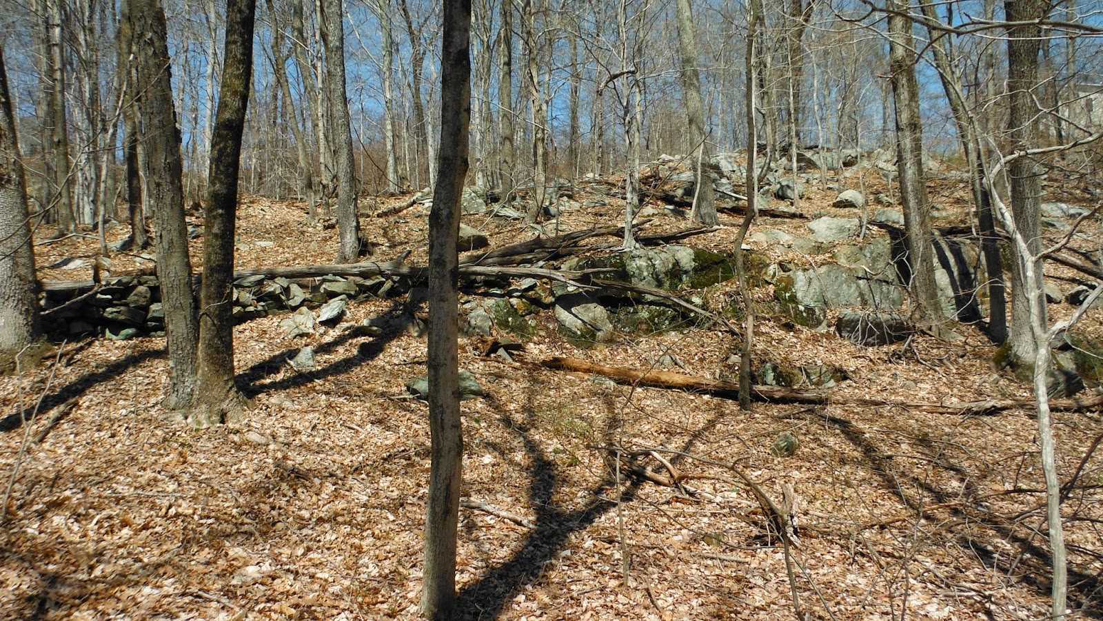
objects are spiritually significant cairns built of ceremonial stones...The cairns, which vary in height from very low to about 3 feet, are of different shapes and construction and scattered throughout the woods. Many are rounded mounds of stones, and others consist of smaller rocks placed on large boulders. Some are obvious, but there are those which are more difficult to see, having sat in place for so long that they have settled into the forest floor.
Conservation Commission Chairman Harvey Buford said he believed they were spiritual artifacts, not waste piles from land clearing, and he hoped they could be preserved.
“This ceremonial site covers hundreds of acres,” he said. “This was much more than a pasture. There is no historic record of people stacking rocks for a pasture.”
Asked to describe his ideal solution, Buford said he hoped a conservation group would buy the land.
“That this extraordinary stone site be respected and preserved and recognized for what it is, which is very clearly not colonial. For me, the ideal would be for this to get so much attention that somebody buys it. Look at that,” he said, pointing at a large stone structure topped with smaller stones. “That’s not a farmer’s mound. That’s beautiful.”

{Jeff’s beautiful photos of these beautiful stone prayers show's you just how beautiful: https://www.flickr.com/photos/sgobbare/sets/72157644328287253/}

      "In a Dec. 12 written assessment Ives prepared at the request of the land owners, he stated that he believed the cairns were evidence of old land-clearing practices.
      “This parcel contains numerous stone pile features, consisting of stones that have been stacked or piled by hand,” Ives wrote. “Constructed on varied surfaces, including the forest floor, ledge outcrops and freestanding boulders, these features vary substantially in form and size, as well as in the range of stone sizes they contain. While I cannot directly date their construction, they appear to be clearance cairns associated with past farming practices.”
       But Doug Harris disagreed. Appearing at the Planning Board meeting, he referred to the cairns as “ceremonial stones” that had been “left by the ancients” on the property. He thanked Kingman and Devine for not having disturbed them, and proceeded to explain their spiritual significance.
      “I have a lot of respect for my colleague in historic preservation, Timothy Ives, but he is not a specialist in tribal historic preservation or tribal culture or tribal ceremony, Narragansett or any other tribe,” Harris told the board.
       The room fell silent as Harris described the spiritual meaning of the cairns to the Narragansett people.
   “Stone is a vehicle for receiving and transmitting prayer. So every one of those stones, as we do in our tradition, was placed by someone, some man, some woman, in prayer. A prayer was spoken into it and placed on the earth and that was to be received by our Mother the Earth and we as her children were to be balanced and harmonized by virtue of that relationship,” he said.
    “In a very different sense, it is our church. We have that kind of an intimate relationship with the landscape … Now I can’t tell you what you should do with regard to what’s on your property. I don’t have that right,” he told the landowners. “I do have a responsibility to ask of you to look for a moment through our eyes and open your spirit to what most people feel when they are in the presence of those stones.
   Tom Helmer, Hopkinton Historical Association web master and the author of a book on the area’s colonial and indigenous archaeology, told the board that he agreed with Harris that the cairn field was of spiritual significance. Helmer has taken many photographs of the cairns, which, he said, he came upon without realizing he was trespassing on private property. Those photographs were given to planning board members.
“A portion of the land in question contains a remarkable cairn field. In an area roughly 75 yards square there may be more than 100 cairns, hand placed piles of rock that carry great spiritual importance in the living culture of the indigenous peoples,” he said. “It is vital to be aware that the places shown on this page be viewed with the same respect we show for our culture’s spiritual places.” 
A small sample of Mr. Helmer's excellent work, despite being self diagnosed with Turtle Fever, something that this blog's author can certainly understand and identify with, is "Seeing The Narragansett Presence: http://www.hopkintonhistoricalassociation.org/page41.html and The Hopkington High Place: http://www.hopkintonhistoricalassociation.org/page95.html.

And as Mr. Bellafonte sang, "Man Smart, Woman Smarter:"  http://secretlandscapes.blogspot.com/2014/04/hopkinton-site-in-lidar.html

Tuesday, April 29, 2014

A Single Stone Turtle

Here’s one that I just can’t publicly say where it is because I can’t be sure someone might decide it would look good in their rock collection (or garden), go look for it and snatch it up. It’s a single stone representation of some kind of turtle that I can’t identify by species, a piece of artwork that could stand on its own, but oddly enough is sort of hidden in a row of stones somewhere along the Housatonic watershed. 


I had my hand on the stone that rests on it and was tempted to remove it and others from the row of stones to take some photos of hard to capture details but I didn’t. I just couldn’t cross that line into vandalism. This is the finished side above. The other side doesn’t appear as remarkable:


But then again, perhaps the other less remarkable side is sort of a clue as to how the turtle was created – “sculpted” you could say, maybe.
Someone wiser than I might say that you can see some fracture marks on this rougher side, evidence of pecking and polishing on the more finished side.
Or a “glacially fractured piece of stone with evidence of water wear or some other sort of weathering on the more exposed side that is merely a geomorph on a typical Anglo American stone wall that was unintentionally made by tossing field clearing stones up against an early wooden rail fence.”

Friday, April 25, 2014

America Before Columbus (National Geographic documentary)


"History books traditionally depict the pre-Columbus Americas as a pristine wilderness where small native villages lived in harmony with nature...But scientific evidence tells a very different story: When Columbus stepped ashore in 1492, millions of people were already living there. America wasn't exactly a New World, but a very old one whose inhabitants had built a vast infrastructure of cities, orchards, canals and causeways...In 1491, more people lived in the Americas than in Europe...In 1492, the Americas were not a pristine wilderness but a crowded and managed landscape..."

http://www.whitewolfpack.com/2014/03/america-before-columbus-national.html


Thursday, April 24, 2014

Turned Around to Look at a Turtle

"My but what large forelegs you have, Grandmother..."

While driving that same old drive home down Quassapaug Road, coming back from  where ever I went - Staples or the grocery store or something - the light was just right or something and thought I saw something. Something Testudinate, to be exact.
"Where is it?" I said to no one in particular, "Where's that Turtle?"
(Or maybe to myself, because often that's the only way I can get someone to agree with me.)

Well that's a new one: the right foot and the platform are a single stone.
It required little imagination to paint in the eyes, the lighter spots were already there:
I'll do a little magic trick now, change a turtle into a bear:
The turtle down below says, "Not that old trick again! Next you'll place some branches on it and tell me it's really a deer, or a moose or something..."
And I say to the turtle, "Shows what you know! 'Most all the authorities say you're just a post-contact phenomenon - Indians had no reason to build rows of stones and, further more, they lacked the intelligence to place one stone on top of the other until Europeans taught them how to do so. And you can't be a sculpture or a petroform or whatever - all the Pilgrims said they had no idea what ART was! And they were so correct about the witches, so we can't doubt their words about that! "
The turtle just sighed, closed his eyes, and went back to sleep...

Monday, April 21, 2014

Veteran's Park 2014

A little monster who calls me Grandpa on a fiberglass fake rock with no safety rails

I once wrote up a little bit about Veteran's Memorial Park in Watertown, CT, a place I find myself going to every now and then since the early 70's when we used to take field trips there in my Biology class. Last time I was there, I came across some stuff I wrote about here: Veteran's Memorial Park. I spent part of Easter Sunday 2014 there with two of those little monsters that call me Grandpa.

        On the edge of that Play-Scape (as they call them now) is an outcrop of bedrock with a kind of "gapped row of stones" stretching across it, but with one end of it blasted into submission so a restroom could be built: 


Most of the chunks of stone were tastefully bulldozed out of the way. Some of these, however, were chosen to be artistically placed here and there, a few with little plaques added to them as memorials, like this one:
Well, the light hit the stone just right Easter Sunday, up on that weathered corner that was part of the exposed bedrock and I kept looking at it, thinking that if I didn't know any better, I'd swear on a stack of dictionaries that someone had carved a a bear's head into that stone. So I got closer:
And closer still:
And I still really don't know.
Like I don't know if this is a bird:
Or this a grinding slick and some grinding stones:
 

Sunday, April 20, 2014

South Facing Slope of Bladens Brook Open Space


(Peter was talking about it here: “Game on!” {http://rockpiles.blogspot.com/2014/02/woodbrige-ctgame-on.html} and circumstance brought me by the preserve on Thursday (4/17/14), with some time to stop and look around - and I had posted a couple photos of screen shots here:  http://rockpiles.blogspot.com/2014/03/waiting-on-woodbridge.html).
PDF Map, showing the “stone wall” pictured above –and by the roadside below: http://woodbridgect.org/filestorage/8419/111/Bladens_Brook%2C_Russell_Swamp_%26_Round_Hill_Trails_-_color.pdf
And this seems a handy place to hang this up: http://woodbridgelandtrust.org/WLT/our-properties/trail-maps/
     I never really got too far out of the Woodbridge part of the preserve that borders on what really amounts to some easements between houses (as does the Naugatuck Trail) in Bethany, spotted only one rather large Rock Pile and just one other smaller one which was a little bit of a surprise, knowing that on the next hill south, Peck Hill, you can’t swing a cat without hitting a Stone Pile - and it doesn’t have to be a cat with a particularly long tail.
     It was the remnants of the mostly linear rows of artistically stacked rows of stones, cobbles and boulders, most likely Indigenous in origin, that turned out to be the most interesting features.
Here’s a couple bing map links that will show you better some of the “stone walls” I encountered: http://binged.it/RrvorC, http://binged.it/Rtzbog and http://binged.it/RtyN9b.

    And I know you are thinking, “Generally when I see walls meeting at right angles I think colonial farmers,” but up on top of that steep southern slope of a hill that’s just a little south and east of Skokorat or "Snake Hill," what you see with boots on the ground might make you want to reconsider…
     In fact, I suspect a little linear remnant of stones along Sanford Road, under the word bridge on the map above, to be of Native Origin: 

This segment was made using a lot of interesting artistic stacking techniques, sometimes perhaps to resemble animal heads. It is not your typical tossed stones or laid up “two on one” sort of imitation brick work that I think of as the Yankee style of stone fence making:
    Maybe there was some human enhancement or 'sculpting" of this one in the past, softened and less easy to see under all lichen and weathering? 

And since we’ve got our boots on the ground of Turtle Island, does this remind you of a certain animal that figures highly in Native American Culture?

There’s a purple tint to that big chunk of quartz in this lacy segment: 
The other side:

       Of course we all know stone walls only came about from road or field clearing, animal containment schema and to delineate property boundaries:


The construction mode changes further down the road, near the brook, with a bit of European flavor to it. I'm guessing it was rebuilt and used some dressed, quarried stones along with the reused Native Stones. This is the other marked roadside segment marked on the map:

But there on the other side of the road, some zigzag stonework shows still, and as always I wonder which came first, the stones or the wooden rails… (27-28)(212)


And up above, a row of stones finally shows, by a spring or “break out zone,” if I’m using Peter’s term properly. Is there a sort of structure to it? Maybe…
Maybe…
Anyway, it gets more interesting in here, around that "T" shown on the trail map, incompletely shown. 

2023 Edit:
See the row of stones behind the row of stones in the foreground above?

Here it is closer:

and here's the overlay I missed back then:


These stacked rows of stones extend up and into - get incorporated into the outcrops above - and also "run over" another below:
...and it’s difficult to tell what’s natural and what’s enhanced…
…and stones like these are stacked upon the row: