Monday, November 27, 2006

Day of...


“The first official "Day of Thanksgiving" was proclaimed in 1637 by Governor Winthrop. He did so to celebrate the safe return of men from Massachusetts who had gone to Mystic, Connecticut to participate in the massacre of over 700 Pequot women, children, and men…”


UAINE and the history of National Day of Mourning: “In 1970, United American Indians of New England declared US Thanksgiving Day a National Day of Mourning. This came about as a result of the suppression of the truth. Wamsutta, an Aquinnah Wampanoag man, had been asked to speak at a fancy Commonwealth of Massachusetts banquet celebrating the 350th anniversary of the landing of the Pilgrims. He agreed. The organizers of the dinner, using as a pretext the need to prepare a press release, asked for a copy of the speech he planned to deliver. He agreed. Within days Wamsutta was told by a representative of the Department of Commerce and Development that he would not be allowed to give the speech. The reason given was due to the fact that, "...the theme of the anniversary celebration is brotherhood and anything inflammatory would have been out of place."
What they were really saying was that in this society, the truth is out of place…”


Accessed Nov. 2006 from: http://www.uaine.org/

Wednesday, November 15, 2006

More Thoughts about "The Map Thing"


Since I just happened on these files from recent years, I thought I'd say a little bit more about maps and what's really on the ground.


I'm not going to tell you exactly where it is.
But it is on a floodplain field.
When English settlers moved here in the late 1600's, they took over and put under cultivation the already cleared fields that stretched for four or five or more miles south of here.
They didn't take over this "meadow" because there were Native People living in the area who were already planting here.

You can't really see some important water features above, except for that thin blue line which is actually a ditch that diverts the stream from where it originally flowed...

So here's the (blurry) aerial photo I got from somewhere sometime of the same place.

And here's my enhancement:

The blue is an intermittent sort of stream. There was a 100-year flood back in August 1997 that "flushed out" this stream. The red lines are a serpentine row of stones and some remnants the flood uncovered. The purple is zigzag stone rows.
The green is apple trees; some are very old, some sprouted from old roots of old ones.
The yellow triangle is a sort of solar calendar that marks the summer solstice and and the two equinoxes.


An old drawing, not very good since it doesn’t show how serpentine the row is, is reproduced below.

Hmmm. I seem to have drawn a mound in there that doesn't exist. Perhaps I was interrupted before I could draw a line from that mound to the "Buried Turtles" spot. My idea was that the farmer who robbed the graves probably found it easy to pile the donation stones in a straight line running north and south as a property fence, to which more modern wire fences have been added. Some of the chestnut posts still remain to today too.

Forever removed also is soild proof that the Burial Grounds ever existed; it's now nothing more than a Grandfather Story, illustrated with an old woodcut in an old history.

Tuesday, November 14, 2006

The Walls and Me

So here’s me, looking at more stone wall information from acceptable scientific sources, the “lunatic fringe” that includes (me and) many friends of mine, and the actual stonework I see on the ground around me. The first group says “There’s little bits of Native American made stone work,” the second group says there is a lot, and the last group is slowly disappearing.
My resume includes years of wandering in the woods, the place I’m most comfortable in this world, as well as living in this old house of ours where I’m even more comfortable.
The occupation I had for the longest time was a Restorer of Antique Furniture - I “peeled back the years” of history to get to the original state of pieces of furniture. I’m applying the same techniques to this home of ours to do the same, keeping in mind that my limited budget allows me to keep intact some historic changes that are part of the house’s history.
This is a long story – I may have to return as a ghost to ever finish the project- and I don’t want to get distracted by going into it too much.
It’s all a part of an ability to see things as they were, a natural talent to which self education eventually added up to some sort of notoriety to be able to be considered quite good.

My wanderings sometimes led to puzzling bits of stonework and I relied a lot on the works of Eric Sloane to explain some puzzles to me. He even had a great explanation for Zigzag stonewalls. It’s the one almost everybody uses as they write about them.
Before I started this blog, I posted that explanation at my friend’s fine blog:
http://rockpiles.blogspot.com/2006/03/sloane-et-al-tell-you-this-is-how.html
But I found another scan from an old floppy disc:


I accepted that explanation for the longest time until I read about Indian Fences here and there, including the first two before coming up with my own idea based on other rows nowhere near vast areas of floodplains where I live, much of it still cornfields and hayfields etc.
http://rockpiles.blogspot.com/2006/03/3-hunting-fences-from-tm.html
I developed a hunger for information and read local and not so local histories and journals and books and eventually found my sister Joan had a book she’d used as a student at UCONN.
http://www.ecobooks.com/books/changes.htm
(Cronon writes):
"What most impressed English visitors was the Indians' burning of extensive sections of the surrounding forest once or twice a year. 'The Salvages,' wrote Thomas Morton, 'are accustomed to set fire of the Country in all places where they come, and to burne it twize a yeare, viz: at the Spring, and the fall of the leafe.'
"Here was the reason that the southern forests were so open and parklike; not because the trees naturally grew thus, but because the Indians preferred them so. As William Wood observed, the fire 'consumes all the underwood and rubbish which otherwise would overgrow the country, making it unpassable, and spoil their much affected hunting.' The result was a forest of large, widely spaced trees, few shrubs, and much grass and herbage. 'In these places where the Indians inhabit,' said Wood, 'there is scarce a bush or bramble or any cumbersome underwood to be seen in the more champion ground.'
"By removing underwood and fallen trees, the Indians reduced the total accumulated fuel at ground level. With only small nonwoody plants to consume, the annual fires moved quickly, burned with relatively low temperatures and soon extinguished themselves. They were more ground fires than forest fires, not usually involving larger trees, and so they rarely grew out of control. Fires of this kind could be used to drive game for hunting, to clear fields for planting, and, on at least one occasion, to fend off European invaders."
Elsewhere in the book, Cronon writes that this is a generalization and that such things are best studied at the local level. “Soon extinguished themselves” was an idea that seemed a little haphazard, and looking at distinct areas never cultivated around where I lived (and those Native People as well) led me to think about control of these fires. You wouldn't want to recklessly burn up everything around you:
http://rockpiles.blogspot.com/2006/03/this-stone-firebreak-wont-burn-tm.html

Some more Cronan:
Changes in the Land: Indians, Colonists, and the Ecology of New England
by William CrononPaperback - 241 pages 1st Ed. edition (June 1984) Hill & Wang Pub; ISBN: 0809001586


http://www.ecobooks.com/books/changes.htm
http://www.rsiss.net/ecology/changesinland.html
http://rvannoy.asp.radford.edu/rvn/680/digests/meller1.htm

From what looks like some sort of homework assignment I found “Things To think About…” where I like the last question best since I’d reply “Look at some stonework that might be ancient.”

http://ocw.mit.edu/NR/rdonlyres/History/21H-421Spring2004/448FF6EE-38BE-4BA2-A242-BEE1553FD2A2/0/cronon_chs_ques.pdf

http://www.nescb.org/epublications/winter2001/salett.html
(and a link to
http://www.massaudubon.org/Nature_Connection/Sanctuaries/Broadmoor/index.php )

http://history.wisc.edu/cronon/Writing.htm

Monday, November 13, 2006

Abandoned Walls

From a simplified classification of Stone Walls, I found this description of ABANDONED (Stone Walls): "More affectionately known as "wild walls," this type is usually fairly old; farmstead walls walls that have since tumbled and become unkempt. 
Very few of these (especially the oddest-shaped constructions) may be pre-European in age.
 Regardless of their original origin, all have since become ruins. Thorson Photo: Abandoned wall in UCONN Forest, Storrs, CT. These are the woodland walls where, if a stone falls down, it's usually left where it fell. They are not taken care of. This makes them no more, and no less, wild than the creatures that live on, below, within, and near them. The fact that they are tumbled doesn't diminish their importance, because they have become part of local ecologic and watershed processes. For clues, look for walls that are: Surrounded by trees Tumbled and damaged, especially along the top. Occupy large land tracts. Covered by lichens and moss. Seldom made of quarried ston(e)." Acessed from WWW, Nov.13, 2006 from: http://www.stonewall.uconn.edu/Conserve3types.htm

Friday, November 10, 2006

Spiderwebs


This is sort of a response to the Rock Piles post of Monday, November 06, 2006 that entitled "The Rock Pile Site Prediction Experiment," as well as a sort of request I keep making of my good friend and fellow "rock guy," that also goes out to those who read our pages here in Cyber Space. I'm always saying "It looks like a Turtle" most often but I also keep asking "What about that stone row behind the mound?"

I'm curious what that's connected to, if it's ancient, if it's Native made, if it makes sense in a sacred landscape, is a remnant of a higher degree of civilization that just doesn't seem to be recognised or accepted.

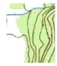
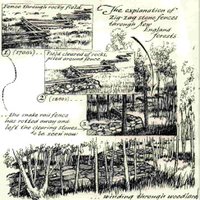
And of course to admit that I am also guilty of the same charge since I'm the person who just recently wrote this at this blog: "The zigzag rows are disturbed by the road but they continue to the south, concealed by brush. And if I did follow them in the past, I don't remember well enough to tell you where they lead."

And I haven't gone back up to look either.
But I shall, in fact will.
Soon.
Really.


So to start out, I guess I'd have to bring up something from the depths my memory, a sort of uncataloged museum where it's easy to get lost.

Some scientists from somewhere showed some Native American Elders some electron microscope photos and some telescope photos to get their reaction about the similarities between atoms and solar systems and galaxies (or something to that effect - the museum is not well lit either).

The Elders weren't very surprised; in fact they said something like "That's what we've been telling you people for a long time. We're glad you finally see. There may be some hope for you after all."

My friend Wendell Deer With Horns, who has wandered around with me to some of the sites I write about always says (as some archeologist shoots down a theory of mine - or refuses to listen - or accuses me of building all these miles and miles of stone rows and the "stone on stones" and all the other stuff) "They just don't see it's all connected."

I think it's an important perspective - and I'll use a couple spots as examples.
My "discoveries" go back to the burial grounds. Missing mounds now, but woodcuts and an ancient history document them; some of the stones turned into a property type stone fence, with posts and barbwire, running along north/south, probably by survey. But underneath is a serpentine row along where the river used to flow. A 100 yr. flood exposed more of it for a while, both sides of the stream stone lined/defined/managed (I'm not sure what term describes it best). When I followed those stone rows I came to the swamp that drains two different ways, that Tobacco Bear and other stones on stones in it.
I got to The Mound swamp because I followed the stone rows from the power line road, just like I followed many a stream with rows or rows across dry land.
I've got guesses about blueberries around it, fire maintained, stone row protected, but I think the swamp may have been burned too when conditions were dry perhaps, the rectangle that encloses the rows burned at some sort of time interval, the forest lands outside at other times, like the mast forest above my house.
(I should have links all this stuff, but I don't - not sure if I wrote it at my blog or Peter's or at Neara and I'm running over my self imposed time limit so I can really get things done, so I leave it up to your memory or search capabilities until a later date.)
So I wonder if those mounds you (and everyone else) are finding are in some sort of space defined by stone fences, for maintenance purposes, particularly by Native Use of Fire, capitalized because of it's widespread use for a very, very long time on Turtle Island.

And it's sort of part of the Connectedness thing, links to earth and sky and and people and trees and animals and stones and the Great Turtle and the Great Mystery.

So, yes I agree that water is important and is a great clue, but don't forget those stone rows - and what Wendell says about everything being connected.