Showing posts sorted by relevance for query westbrook. Sort by date Show all posts

Sunday, June 21, 2015

Obed's Hammock and Clam Gardens


So I’m thinking “Are there any CT clam Gardens??
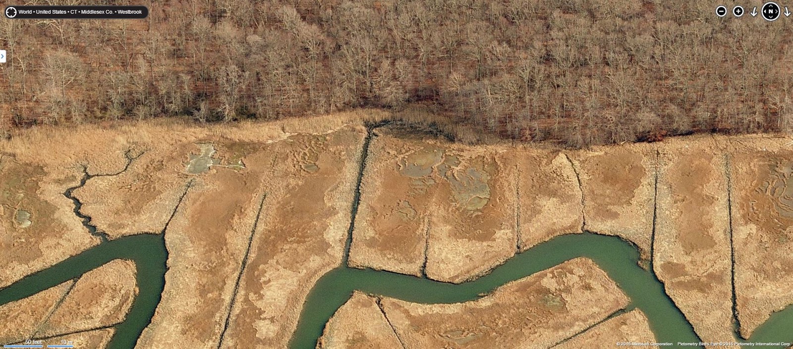
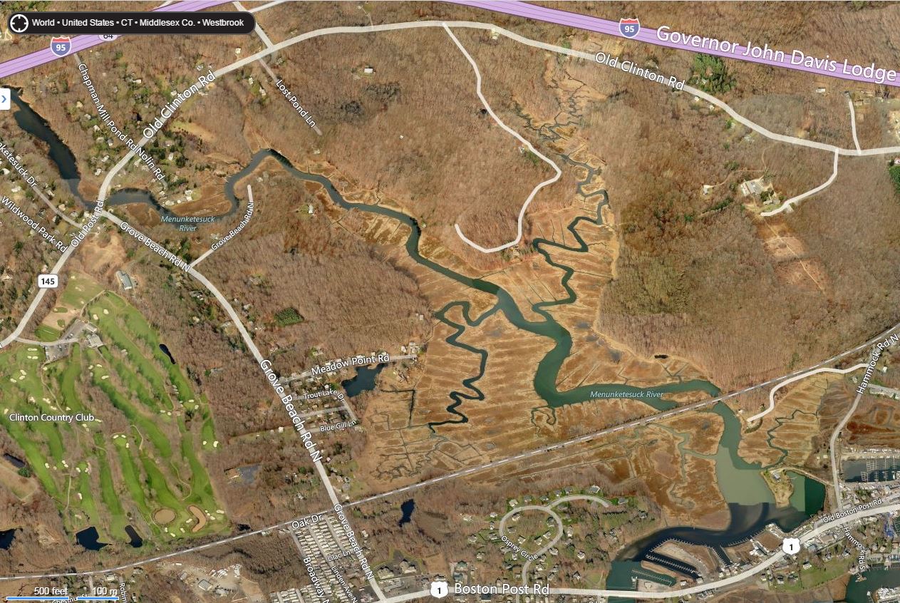
So suddenly I’m thinking of the Menunketeset River in Westbrook CT where I spent not enough time every year “hunting and gathering” Blue Crabs.
(Westbrook CT above, Pot Hook Creek below.)

So I go to those aerial views I can find, see how they compare to the Clam Gardens of Pot Hook Creek, to see if there are any visual similarities.

      And I think, “Well, maybe. Maybe those just might be something like that,” up the river from the Village once known as the Hawk’s Nest, maybe sometimes called Obed’s Hammock or maybe just confused with another place in Saybrook and I get lost a little trying to “Google it down:”

    "The quarter was set aside to provide farm and pastureland to residents of Saybrook Point. Permanent settlement soon followed. The area became known as Pochough, a Mohegan word meaning "at the confluence of two rivers,'' the Pochoug and the Menunketesuck rivers, home of Chief Obed and his tribe. The area has long been home to Native Americans, and a large village was at Hawk's Nest, now known as Pilot's Point..."  http://www.courant.com/hc-ot-westbrook-htmlstory.html
The Gages: http://www.stonestructures.org/html/pilots-point-stone-mounds.html


     But I get back to those images, and I move around in location - and in time, as my friend d.c. in Delaware sometimes does and has shown me how.
Or go to 1934:

Look for yourself up close: http://binged.it/1fqoyyb
And feel free to move in and zoom around.
And I’m still thinking maybe.
And I’m thinking “Could I get in there with a canoe or a kayak and sort of look around?”
And I’m thinking of all that stonework all around there on the dryland above those salt marshes, trying to recall if I’ve ever seen any extending into the salt marshes, wondering if there just might be some clam gardens in there.
Especially in the National Wildlife Refuge:
McKinney Sea Turtle?

    “Why not?” I’m thinking, despite all the dredging in the river and all the mosquito channels in the salt marshes - and the next terrace or two above the marshes where some pretty good examples of Indigenous stonework remains if you have the eyes to see it…


Wednesday, August 06, 2008

Mom's Back Yard, Westbrook CT


I can’t find what I started writing about last, but it was after July 5, 2008, the day I discovered the bull’s eye ring associated with Lyme Disease. It was a rough 3 weeks and then some, feeling the effects of the disease and suffering from the side effects of the anti-biotic.

But I ended up camping in my mom’s back yard down in Westbrook CT at the end of those three weeks, slowly feeling better. It's the house circled in red on this 1940's map - and found an interesting Rock Pile on a Stone Row that is the big red dot:

“Westbrook was settled in 1648 as Pochoug, an Indian word meaning "at the confluence of two rivers", the Pochoug and the Menunketesuck, by the residents of the Saybrook Colony. Pochoug was the dwelling place of Obed and his tribe until 1676. The community was incorporated as Third or West Parish in 1724 by an Act of the General Assembly.

Westbrook is the birthplace of David Bushnell, the American patriot and inventor of the submarine (He called it the Turtle). It was visited by George Washington in 1776 and by the Marquis de Lafayette in 1824.

Pochoug was renamed Westbrook in 1810 as a town by Act of the Connecticut General Assembly of 1840.”
http://www.westbrookct.us/townhistory.php?PHPSESSID=95d44b578f52c50aa0e54ee771257020

That name, Obed, pops up alot in the area:

TOWN OF WESTBROOK.By James A. PRATT
The History of Middlesex County 1635-1885J. H. Beers & Co., 36 Vesey Street, New York1884

"…(T)he Indian name of the settlement was Pochoug, a word signifying the place where a river divides, and descriptive of the location of the principal tribe at OBED's Hammock, at the confluence of Pochoug and Menunketesuc Rivers. The large quantities of arrow heads, broken pottery, shells, and other Indian remains that have been found and are being unearthed in that vicinity, are evidence that it was some time the abode of a numerous and powerful tribe.

A very common name for the western part of the town, in ancient annals, is Menunketeset, or Menunketesuc, in Indian dialect, Ma-na-qua-te-sett. The name is of Mohegan origin, and was applied to the West River, and the section bordering upon it, after its possession was claimed by UNCAS. In his deed to Saybrook, in 1666, it is written, Menunketeset, and it has been spelled and pronounced every conceivable way since. The significance of the word is lost. The soil on both sides of the rivers is a mass of shells, the remains of clam and oyster feasts before the discovery of America. A remarkable feature of the vicinity is the great number of broken or unfinished arrow heads to be found at Round Hill, on the east side of the river. The only explanation for this is, that it was the headquarters for the manufacture of these implements from the late and quartz found on the beach near by. This Indian settlement was probably abandoned at the annihilation of the powerful Pequot tribe, to which they belonged, in 1637.

The Hammock was subsequently occupied by OBED and his tribe, from Niantick, on the western border of Rhode Island, and within the jurisdiction of the Connecticut colony at that time. The small tribe were living here at the time of the arrival of the first whites, and were known as the Menunketeset Indians. They returned to Niantick about the time of the King Philip war, in 1676."
http://www.dunhamwilcox.net/town_hist/westbrook_hist.htm

I can quote myself here:

"Histories of the Saybrook, CT area include mention of Obed and "Obed's Sacrifice Rock." Obed appears to have been a "son of a Hammonassett Chief; and after the subjugation of the Pequot, a servant to Gov. Fenwick: that Fenwick did give him...two acres more or less near the confluences of Pychaug & Menunketezuck rivers, known as Obed's Homake."

He later lived near Springbrook Rd, "passing most of his time in the retirement of his wigwam or the solitude of the chase." Obed's Sacrifice Rock was a boulder "contiguous" to his "aboriginal structure." The author continues to write in a language somewhat similar to American English, "Upon this symbol of pristine faith, was kindled from time to time, a fire which consumed the sacrifices tendered, with sweet incense from bay and birch; mingled with the fumes of tobacco." "

http://www.neara.org/macsween/macsween.htm

A little more OBED from

The History of Middlesex County 1635-1885

J. H. Beers & Co., 36 Vesey Street, New York

1884

Pages 282-320
TOWN OF OLD SAYBROOK.

BY WILLIAM B. TULLY


After the Indians were subdued, some of them were servants to the whites, and others lived near them and became partially civilized, many of them taking English names. They gradually decreased, however, till at the beginning of the present century, only a few stragglers remained. The tradition has come down to us, that Obed, one of these Indians, sacrificed a deer to the Great Spirit on a hill about half a mile north of the head of Main street. The hill is still known as "Obed's Alter Hill," though the exact rock on which the sacrifice took place is not known. It was, however, one of the high rocks on the east side of the hill, and it is not visible from the turnpike. Who this Obed was is not known, but an Indian of that name was a servant of Colonel FENWICK, and it is probable that he was the one. Years afterward he laid claim to a piece of land, which the following entry in the town acts explains: "The Teste of William HIDE and Morgan BOWERS, who certife & say that wee do well Remember that Obed the Indian was a servunt of Mr. FENWICK the space of four years, & we are able to say he was a faithful servant to him, & that for his service, Mr. FENWICK Did Ingage a parcel of Land to him, We cannot Justly Say what Quantity, But we Do conclude it was not less than four acres, and that Obed's father Did Possess the Land before the Serviss of the said Obed was out. To this we Can Safely take our oaths.

"This was given in before me, John MASON, the 19th of May 1673."


My mom's yard today - and the rock pile again in red:


There's been lots of newer stone walls built since the 1600's, but I think I see the "Indian Look" of the oldest of stone rows (built very similar to rows I've follwed in Rhode Island) and I wish I'd had the time to just follow those stone rows rather than just glimpse them from my bicycle as I rode by, especially in the property newly acquired by the Stewart B. McKinney National Wildlife Refuge (http://www.fws.gov/refuges/profiles/index.cfm?id=53546).


But here's the one at the edge of the property.


In the distance is I-95; that sort of hump in the middle of this section of stone row is a sort section of stone row that ends with a big end stone above what's now a little pond, but probably was a spring:


I stepped onto the highway side to take this photo of it, a steep bank below the big stone at the right, a curious collections of smaller stones on the row to the right of the the big boulder in the middle...


The few stones I did pick up, I turned in my ands until I found some comfortable way to hold it... .. hand axe, maybe...


...but I think it's that pile of stone tools, sitting on a stone row at a spring, maybe an old camp, maybe just a spot where tools were left rather than carry around hand axes and hammer stones, abraders and nut crackers and who knows what else, right there in my mom's backyard.
Monday, July 06, 2015

All the Places I Didn’t Go on the 4th of July

(Or the 3rd or 5th)


     There’s so many places I didn’t go on the 4th of July 2015.
     In fact the only place I did go was up “on top of the world,” as two of my grandkids call it, up to a vantage point on Hard Hill Road where we watch fireworks from a distance, some legal, most illegal, bursting in the air.
     But the day before and the day after, my wife and I drove down to Westbrook where my mom lives so we could hang out with family visiting from far away, my son’s family from California, my brother’s from Kansas City.
      I was going to slip out to the stone wall behind my mom’s or maybe down to the river and the salt marshes but I never did. I was going to look again at some of the stone features or hunt for a clam garden in the salt marshes, but I didn’t have shoes, I forgot to bring the tripod and the tide was extra high, all those same old excuses.


      Mostly I looked at the new stone wall the neighbor across the road is still in the process of building in front of his house:
    I took a couple more shots of it, my only “stone” photos except for two other ones. I had to pull over to take this one, which isn’t much of a photo, but it shows the aftermath of the selling off of a beautiful row of stones, some of which ended up at the neighbor’s, and putting up a plastic privacy fence by a new housing development that just sprung up while I wasn't paying attention:
     The best I can do is to show you “before” is this lousy google earth street view capture before the pillaging took place:
    And sure, I got a couple old aerial “befores” from bing bird’s eye view:
The above might be the best, showing an undulating row of stones, perhaps representative of a Serpent Petroform…

      The biggest problem with bringing Stone Features of the Indigenous Landscape into an actual scientific “big picture” of a remnant of a Cultural Landscape is the mountain of documentation that has been built about “stone walls” without any real true investigation into stone walls.
    I’ll give you a piece of a little bit of this from a 1995 newspaper story, published just a few years after I began to seriously doubt just about everything I’d ever heard or read about stone walls:
     “Many New Englanders view them as beautiful monuments to the industriousness of our ancestors, enduring remnants of a dying agricultural way of life. They believe all walls are like the carefully constructed jigsaw puzzles at estate entrances and roadsides.
      (Robert) Thorson doesn't see walls that way.
     ``They're simply linear piles of refuse,'' he says…
       Thorson, a geologist at the University of Connecticut who has written a book about stone walls, is no romantic. He has the eyes of a scientist.
      ``We use them as a touchstone to the past, almost a yearning past,'' he says of walls such as the one in his backyard woods in Mansfield. ``I see walls as eco-facts rather than artifacts.''

       The traditional story of how walls came to be is too simple, Thorson believes.”


       Well now, I think, it looks like we agree upon two points then. Finally. I agree with one more thing Thorson has said – the first that stone walls function as fuel breaks, but also that the traditional story is too simple
    But still, I’d like to take a look at the stone’s in Thorson’s backyard – to look for some artifacts contained in his stone walls design - pretty far from the view that most stone walls are refuse. Indigenous Cultures inhabited the North East for far longer than that brief agricultural period of plowing fields, using fire as a tool to maintain the Landscape they were creating, perhaps using these stone constructions as fuel breaks in the more densely populated places.
    Maybe something like this, not too far from that Westbrook Stonewall Massacre by North Hammock Road, just across the street from that new wall in my Mom’s neighbor’s yard, out behind Mom’s barn where the stacking of stones is far from accidental, where the artwork of Indigenous stonework shows in some obvious zoomorphic effigies, especially Stone Turtles, are included in a stone wall:


     There’s more here:
     I’ve written about them elsewhere and at other times:
    And a few miles west along CT Route One, in a well-known state park that retains its Indigenous Place Name, is a fine example of a Species Specific Stone Terrapin, perched on and included into a “stone wall:”


Monday, June 13, 2016

Stone Turtle Feet


   Stone Turtle Forelegs really.
   Recognizing them is sometimes easy - other times not so easy; just imagine every shape a turtle foreleg could be and just look for a stone shaped like any real turtle’s foreleg could be, beside a stone shaped very much like a turtles head. 
Or near a nuchal notch if the head is missing.
The more realistic a stone turtle is makes this “more easier” to do, to separate something imagined.
To distinguish if one is observing: 
(1.) a tossed stone Rorschach test by-product of field clearing
or 
(2.) a diagnostic observation of an artistic variation of a repeated pattern that can help diagnose the characteristics of Indigenous Stonework.

  Below is a stone turtle effigy that was covered in old farm junk near a chicken coop in Woodbury CT up until perhaps thirty years ago (1980? 1981?) when an existing chicken-yard was expanded. Chickens excavated this turtle effigy using a method called “scratch and peck” - aka "Hen Pecked." 
The small petroform clearly has a solid, low domed carapace or shell represented in stone, as well as two (rather large) forelegs on either side of a triangular head stone of a quartz embedded stone that has possibly been humanly enhanced, exaggerating the resemblance with the suggestion of eyes and a pointed beak, below a protruding style of a nuchal notch. The shell or carapace stone also has a diagonal band of white quartz running across this probably worked but highly weathered stone.
    The stone turtle’s right leg is extended, the other perhaps at rest but not withdrawn. The left foreleg is also concave, almost as if fitted to the turtle’s stone head.
    Above is another stone turtle effigy found in a row of stones, its left foreleg really extended – super extended, if you will. It has some marks that suggest toes although not as clearly as the one below, in a row of stones in Westbrook CT:
    Below: Turtle stone effigy incorporated into a small stone mound in Woodbridge CT. There may be some human enhancement of some of these stones, although the possibility that a “mimetolith” – a naturally formed stone that mimics a turtle head (or foreleg or carapace).
    None of those turtles with low domed shells reminds me of a specific species of turtle pictured above, although the high dome of the one in my Mom’s Westbrook “stone wall” perhaps suggests a box turtle.
 Close to the brackish water by the shoreline, a very good example of a species specific stone turtle “basks” on a row of stones in Madison CT,  a couple toes possibly worked into the stone that "mimics" the colors and markings of the forelegs of the actual diamondback terrapin (and note how the carapace stone could be said to mimic a scute perhaps...):

(Note the small depression below those toes; a person could burn some tobacco in a shell in that little spot, protected from wind and rain perhaps...)

Above: Swimmer(?) in profile, Watertown CT. Smiling in Woodbury CT, similar colored stones help detect a turtle, and its right foreleg, in a long stone row in the Nonnewaug floodplain:

Near the smiling turtle, a possible “paint pot” rests on turtle feet:

Two views of possible turtle, very possibly split from a single stone, above the same floodplain, just behind a large boulder that could be said to be snake's head at the end of a long stone row:


Just one leg in Litchfield CT:
The only Indigenous stonework I can hang an approximate date on is about 1700, in the stonework of the house my family lives in. There are more examples but here's two views of the retaining wall and front steps, a snake or Great Serpent and a turtle or a Great Turtle, the angle of sunlight and the shadow created highlighting the eyes of each:
Two forelegs extended sideways, head slightly turned in center:
As of yesterday, I am pondering the possibility here that I am seeing another turtle incorporated into the house's foundation:
That could be forelegs on either side of a turtle's head, one disturbed, the other still in place...