"What the Hell!!" Walls
Dr.
John Possum chuckled, turned toward his longtime associate Sherlock Stones
seated in his armchair beside him, and said, “Here’s this one popping up again
on my laptop screen. “The Dreaded Bladed Lace Wall,” Possum announced as he
turned the device so that Sherlock could see.
“Ah! Those so-called
“Lace Walls,” replied Stones. “Named for a stacking technique in Ireland
allegedly inspired by a needlework cultural tradition known as “Irish Lace.” The
technique led to speculation about Celtic monks settling around the NEW England
area, but both also resemble some lacy looking yak fences in the Himalayas but
so far no one has speculated about ancient Tibetan monks traveling the seven
seas to bring this sort of artistically and culturally stacked stonework to
either Ireland or America – or both!”
“I’d forgotten that
he also calls them “What the Hell Walls!” Possum replied in minor amusement and
began to read:
“INTERPRETATION:
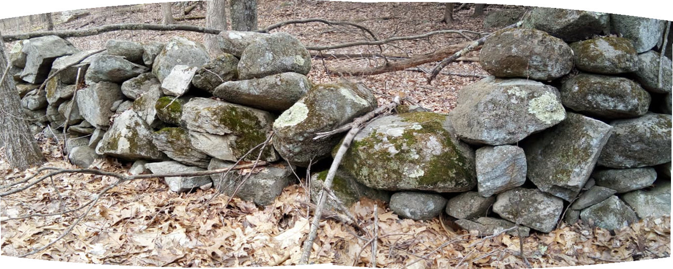
Colloquially, this is known as a lace wall, though it’s a very unusual one
because this shape stacks so easily to minimize pore space..."
(Under his breath, Sherlock Stones muttered, "A geologic metaphor, an analogy of sorts, the term relates to the porous space between the mineral grains of deep rock formations.")
"...Most lace walls are
made of rounded ball-shaped stones which require high porosity and stones not
bearing weight are very unstable. Now,
having described it with a nomenclature and classified with with (sic) a
taxonomy, we can speculate on why. This wall makes no sense as a “linear
landfill” for field clearing. It might have been a fence, but seem (sic: but it
seems?) too low. It could have been a
border to a field or farm. So, let’s
call it an unexplained anomaly, perhaps an idiosyncratic, “what the hell,” folk
art expression of some sort, likely built from locally quarried stone on
bedrock. A reconnaissance of the terrain
would provide other clues. But for now,
let’s just call it a “Bladed Lace Wall,” writes Professor Thorson.”
Sherlock Stones shook his head and said, “Despite being aware
that humans were living in North America since at least 20,000 years ago, when
the Laurentide Ice Sheet was beginning to recede from New England?” Sherlock
Stones replied, “He writes somewhere that, and I quote, “Some aspects of the
stone domain (piles, rings, notable stones, short sections of stacked stone)
were part of indigenous material culture as dolmens and cairns. The trick is to
differentiate these "needles" in a haystack from the "hay"
of the nearly ubiquitous Euro-settlement overprint.”
“Dolmens and
cairns?” exclaimed Dr. Possum. “Right back to Ireland, eh Stones??”
“One immediately
begins to suspect the credibility of anyone claiming that ‘dolmens’ were part
of the material culture of any Indigenous Peoples anywhere, or at any time, in
the entire western hemisphere. One wonders which stone structures the professor
of geology is talking about – or which consulting anthropologist suggested such
a thing to him,” Sherlock Stones pondered. “You have a people here in this
little corner of the continent, repeating these statements of the Puritans and other early settler colonists about wandering nomadic Indians who were too lazy or too “savage,” - “too unintelligent to actually place one
stone on top of the other,” as some have insisted, in print and in public
lecture - despite all evidence of similar stone structures on Turtle Island and
in the rest of the world, for that matter.”
“The Colonial Myth again,” said Possum.
“Here’s another post with a link to a Stone Wall Manual. Here he writes, “New
England walls built by European settlers range begin with the year 1607 from
the Popham colony in south-coastal Maine…”
“Actually, the only
mention of any “stone wall” building in 1607 is that a well was “walled up” –
lined with stones. Part of why a “stone fence” has become known as a “stone
wall. A drawing of the plantation and fort exists, showing massive walls of
stone but on paper and on the ground the fortifications were basket like, dirt
and stone filled more easily built gabions,” Stones interrupted. "It's "Tabla Rasa" all over again, sweeping the Indian off the slate to create a colonialistic history, these days turning more and more toward a Nationalistic mythology."
The doctor continued reading, “In later
coastal settlements the earliest stone features date to the year of arrival in
the first half of the 17th century because primitive wharves and piers and sea
walls were essential. The famous erratic
known as Plymouth rock, dating to 1620, is a notable stone, in this case an
erratic that was moved and imprisoned below the modern wharf. Features on rural New England properties
inland from the sea are typically younger than Metacom's war of 1675-1676 and
are restricted to major settlement pathways like the Connecticut River
Valley. The Concord River Valley, MA,
dating to 1635, is a notable exception.”
Sherlock: The sites of the very first European settler colonist villages were on the sites of Indigenous Villages and the first agricultural fields had been worked by "Indians" for longer and occupied more permanently than is commonly understood before the greatest depopulation of a people, throughout the NEW England region and beyond."
“It speaks to a
very misunderstood picture of the cultural landscape of Indigenous Peoples,
particularly here along this side, the Connecticut side, of the Long Island Sound, described by some very
early European voyagers, often called Explorers or Discoverers, as a thickly
populated place. Verrazano and Smith, as well as others, describe fields and
meadows, gardens and forests, village nestled into village, “cheek to jaw,” on
the landscape. Missing is a picture of a subsistence method that has no good
name, is minimally understood, or something like that I believe Kathleen
Bragdon writes somewhere, yet written in the evidence of “stone walls” that in
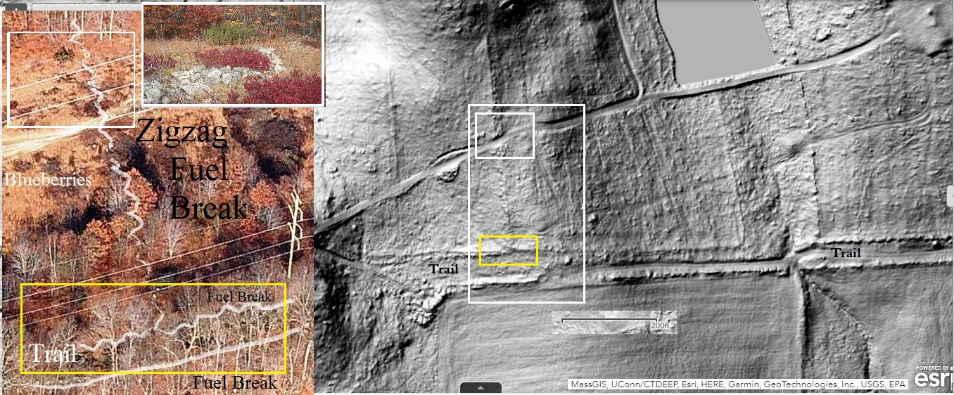
some instances create fuel breaks for managing small parcels of land by thermal
pruning, if one can get past the colonialistic myth that surrounds the subject
of these Yankee stone walls,” Sherlock Stones said. “Double rows surrounding
the roads called pathways as even more “fire insurance,” one could say – roads
that also served in part as game drives in certain locations…”
“Fish Weirs in the
water, retaining rows of stones forming causeways over and along the water
features,” interjected Possum. “The professor gives a nod to “short sections of
stacked stones,” perhaps meaning a Serpent or Big Snake Effigy but perhaps not,
but any “longer than short” rows of culturally stacked or laid stones just has
to be attributable to the “superior culture” of early European settler
colonists – for no good reason other than that’s the myth, the Pristine Myth,
the Exceptional Yankee Myth, the folklore that has almost never been scientifically
investigated standing in its place.”
“A Colonialist
Archaeology, as Dr. Trigger called it years ago,” said Sherlock Stones.
“Turning not merely Nationalistic, but frighteningly Ultra-Nationalistic if one
looks at what is currently going on within the United Staes of America these
days.” Sherlock sighed and fell silent for a moment. “Many well-meaning
researchers who focus on Indigenous Stonework have difficulty “decolonizing”
when it comes to these so-called “Stone Walls.” Some will casually dismiss miles
and miles of “zigzag stone walls” or rectangular enclosures with right angles as
colonial or later “farmer walls,” while yet another will claim to see many variations
of an Indigenous stacking method that intentionally includes creation of effigies,
the inclusion of Indigenous Iconography if you will.”
“I recall that old
trail along that brook, right on the edge of the city,” said Possum. “We walked
up one side on an elevated trail, a causeway, above the good sized stream that
contained Indigenous Iconography seen in other stone structures. We soon found
ourselves looking the very different stonework related to a railroad across the
stony canyon from the Old Path, used to
bring the first dressed grindstone into the area.”
https://wakinguponturtleisland.blogspot.com/2018/05/well-defined-trails-to-mattatuck.html
“Quite dramatic to
those interested in such things,” Stones replied. “Just as the “What the Hell
Wall” might be to the serious student of the long history of Turtle Island.”
Sherlock Stones
plucked a printout from the middle of a stack of papers.
“Here you go,
Doctor Possum, one for your blog:”
More Sherlock Stones:
My own personal note about major settlement pathways and
stone features etc.
Colonial - New England walls built by settlers range
begin with the year 1607 from the Popham colony in south-coastal Maine. In later coastal settlements the earliest
stone features date to the year of arrival in the first half of the 17th
century because primitive wharves and piers and sea walls were essential. The famous erratic known as Plymouth rock,
dating to 1620, is a notable stone, in this case an erratic that was moved and
imprisoned below the modern wharf.
Features on rural New England properties inland from the sea are
typically younger than Metacom's war of 1675-1676 and are restricted to major
settlement pathways like the Connecticut River Valley. The Concord River Valley, MA, dating to 1635,
is a notable exception.”
Not At My House:
I’ll repeat
Thorson’s sentence: “Features on rural New England properties inland from the
sea are typically younger than Metacom's war of 1675-1676.”
And I’ll repeat the
sentence I often use: “Not at my house.”
I live in a house of
undocumented age (unless you count the earliest of Treaties negotiated by John
Minor) built on a foundation composed of “snakes and turtles,” the “Indian
Road” that is sometimes called the Old Connecticut Path, by the site of an
Indian village, the Nonnewaug Wigwams, most often described as a “camp” in most
local histories, a road that followed migration patterns of mega-fauna and facilitated
trade, that eventually connected to other villages and other (sometimes
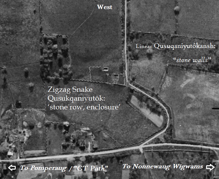
rectangular) “resource zones,” such as “wetland gardens” where food and
medicine grew or Forest Gardens of Chestnut and Oak, rectangular fields of blueberries
separated but also connected by low zigzag rows of stones, so that three fields
continue to produce for every one that is burned over on a four year schedule.
It’s not “burning down forests to clear land,” but more like a way most easily maintain
small “garden enclosures” – with a stone fuel break so you don’t burn up your
neighbors’ enclosures accidently. The spiritual protection of a Great Serpent
or Big Snake adds to the power of these “Stone Prayers,” as I understand it.
One more place where
an abundance of “Indian Stonework” has been disappearing for centuries.
Nonnewaug in Pootatuck,
as some still call it, where I woke up on Turtle Island…
Dawn Spear's painting "As it as Before" and a Chaplain Drawing:
Adding rows of culturally stacked stones: