I can’t tell you
how many times I’ve driven by this little spot in all the years I’ve been
around. I know I’ve taken a walk or two along the trail before, but I have to
admit that as many times as I’d seen that boulder before, the rhomboidal shape
of it eluded me until pretty recently. So I had a few minutes and I stopped to
look around, take a little walk.
Above: the other side, below: the underside speckled with quartz inclusions, some small and rhomboidal.
The boulder on the other side of the gateway:
It’s on the old
stagecoach road that became a highway, going back a few hundred years, but going
further back you could say that it’s a gateway into the cranberry swamp, off
the Indian Trail that leads up into the Berkshires eventually from what is now New
Haven.
And that’s the
other part of it, the possibility that there are Indigenous-made stone walls
that in one aspect function as fuel breaks – stone walls that are also guarding
spirits, Great Serpents made of stone.
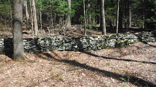
There’s a lowest
row of stones (above), it turns out, long unmaintained and sometimes hidden in tree
debris or ferns as well as the sphagnum moss that is often found growing along
with the cranberry. I walked along it a little, on the drier side mostly,
looking for some of that Indigenous Iconography that whispers to me that this
is a Native American stone feature, a stone border of one of the world’s
largest gardens that is now known as New England, this one surrounding what I
almost called a cranberry bog but is really a Cranberry Garden.
Well, was a Cranberry Garden, back when People were taking care of it well, using Traditional Ecological Knowledge.
And that lowest
row of stones it seemed was one of three more or less parallel rows of stones,
the upper two on either side of what looks to be a trail – just as on the other
western edge of the Cranberry Garden, except that instead of trail a modern
road has remnant stone borders on either side of it. I conjecture that the
trails were burned often to keep them clear – and create a wide fuel break in
the process. If you were clever about it and had a group of people cooperating,
at the time you were burning the trail, you could probably drive some game
along it too, Traditional Indigenous Multi-tasking you might say...
There are some other rows that connect to the other rows, not quite at right angles, maybe related to water, maybe related to control of the water level in the Garden. This one had a large boulder at it's uphill end:
I came across another gateway as I was walking along that lowest row, up a little in elevation, drier on the inside, an entrance into the Cranberry Garden:
Above: east side; below: west side:
(A thin snake head on a bigger thicker snake head?)
Lighter colored stone a little farther along, some other iconography maybe, perhaps better seen in different light conditions:
And these are two poor images I'll have to retake someday, a spot where two sort of triangular boulders meet, possible snake-heads nose to nose:
The westerly one could be said to have the suggestion of a "buffalo-type" of short horn:
Farther on, another light colored stone, placed like one I had passed by earlier, hinting to a purposeful pattern rather than random field clearing - especially since the field part was missing:
And a little further along, another gateway, another big triangular snake-head-like boulder:
A little farther along the row of stones, some sections visible and quite intact...
...another white quartz triangular boulder just barely visible when the wall gets lower and more hidden - and I see it is time to turn back:
But it's a long way back and I'm easily distracted by those stones along the way, reaching up to higher places, that I'll show you another time...


No comments:
Post a Comment