PREHISTORIC TRAILS OF
THE PICACHO BASIN IN THE COLORADO DESERT, IMPERIAL COUNTY,CALIFORNIA
By STEPHEN BRYNE
Prehistoric trails are part of the
cultural landscape of the Picacho Basin in the Colorado Desert of southeastern
California. These trails provide a lasting testament to prehistoric life ways.
Since the early twentieth century, scores of trails have been documented in
this region. The trails, which vary from short segments to over 200 mi. in
length, were used to access resource collections areas, to conduct trade and warfare,
and as ritual routes to sacred sites. A number of trails were recorded in 2010
during surveys for proposed military aircraft landing sites. Observations
regarding these trails, and their significance, are discussed.
“The entire west was crisscrossed by prehistoric trails. In
California, these trails linked all areas: north, south, east, and west
(Campbell 1999:42). Not only were local trails utilized, but super-pathways traversed
and bisected the region and reached trails far beyond, leading to what would
become the adjoining states of Arizona and Nevada (Campbell 1999:42)…”
This following report provides documentation concerning Native
American ethnographic resources that could be impacted by the Rio Mesa Solar
Electric Generating Facility and Includes the Keruk andXam Kwatcan Trail and its
Earth Figures Landscape:
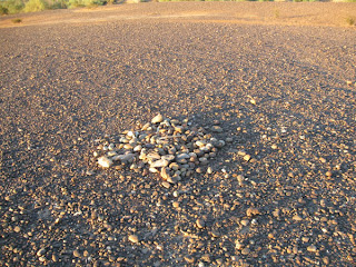
“Cairns:
Cairns or rock piles in the desert often denote
that one is in close proximity to a trail. However, it should be noted that
historic cairns are also prevalent in the Colorado Desert due to mining, and
care should be taken to distinguish between those cairns which are historic and
which are prehistoric (Laylander and Schaeferin draft). Sometimes these cairns
contained cremations, others were used as shrines, and others were simply trail
markers; however, regardless of their purpose, they are “indications of the
eco‐cultural ethic which led Native Americans to pause for a moment and pay
respect before setting foot on the trail” (Bean et al. 1978: 7‐14).
Cairn on desert pavement, not analyzed by the California Energy Commission or Bureau of Land Management.
stolen from: http://www.basinandrangewatch.org/Blythe-Sep.html
And one more:
Ethnographic Trail Systems as Large-Scale Cultural Landscapes: Preservation and Management Issues.
"It is well known that Native American ethnographic landscapes can encompass relatively large geographic expanses (Hardesty 2000; Parker and King 1992). Sacred mountains, such as Mt. Shasta in California, San Francisco Peak in Arizona, and Devils Tower in Wyoming, are examples. What is less widely appreciated is that Native American belief systems often not only refrain from delineating geographic boundaries with respect to specific revered landforms, such as mountains, but also insist on a critical interconnection among what might otherwise be considered separate landscapes..."
http://www.clemson.edu/cedp/
http://www.clemson.edu/cedp/


No comments:
Post a Comment