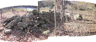
Going back to Uncle Bob's with a camera, travelling the old Indian Trail toward Lake Quassapaug, I thought about how almost none of the zigzag rows that show so well from the 1934 aerial photography are still there today. Much of it is gone, the stones carted off to build other things. One of those other things is my great grandfather's house and the stone wall in front of it, both of which he built...
Here below is a detail from the 1934 photo; the circle on the right is the house and wall pictured in the above three photos; the left is my Uncle Bob's house lot...
Above: Uncle Bob's house (and his rebuilt stone walls).
Below: a little bit of the old zigzag remains in the foreground, in the distance the remnants of what my uncle recalls as a "stone wall," but may be a sort of mound.
Below: possibly a bear effigy
Close up of possible drill mark in large boulder above:
There's more to the day's finds, crossing over to a spring and a former horse pasture below outcrops that appear to have rows "woven" into them and several mounds, including this small turtle mound:
(Blogger is acting up - won't show the photo I wanted the way I want to, turning it sideways, so I'll continue later...)
Later: the small turtle mound:


No comments:
Post a Comment