Monday, May 14, 2007

The Road Realignment


I guess I'm just snoozing on Turtle Island when I should be awake and aware.


I had asked to be notified about any town meetings regarding the road, but I wasn't. I thought the project wasn't going through, but apparently it is...


Nonnewaug Road Realignment
Minutes
Board of Selectmen Regular Meeting
April 26, 2007
Page 2


Nonnewaug Road Realignment Project –Six (6) bids were submitted. Tony Ciriello of Milone & MacBroom reviewed the bids and found Dayton Construction of Watertown to be the lowest and appears to be complete. However, the bid is over budget. Selectman Crane has submitted a request to transfer funds from both a STEAP grant and a LoCIP grant. The combination of the two requests would cover the shortfall. He has received verbal approval
of the transfers and is awaiting written confirmation.
MOTION: Selectman Crane moved and Selectman Hinckley seconded to award the Nonnewaug Road Realignment Project to Dayton Construction Company,
Inc. at $357,565 contingent upon the written confirmation of transfer of funds
by the State Office of Policy and Management.


UNANIMOUSLY APPROVED


So I guess I'll be documenting some more pieces of a disappearing cultural landscape.
This is the linear stone row that leads to the old glacial lakeshore. To the right is the zigzag row...
More to come...

Wednesday, May 09, 2007

My Own Rockpile

I know I said I was going here and there to take more photos, but I've been busy.
I did walk over to the weir on the river the other day and found a little rock pile I made that got washed over by the recent record rains. I sort of forgot it was there, but did see some stuff remained.

I took some weir-side pictures this morning and here they are...


I plucked a couple more abraders and maybe a hammer stone, washed out of the bank on "my side' of the river. I would have walked on top of the weir to get to the erosion on the other side to poke around, but I can't do it anymore - it's slowly dissappearing more and more...


Thursday, April 19, 2007

Thanks Rob B.


While looking at the river, I did see someone I know drive by who stopped to talk and got his permission to look for something else - and found some other stuff...
In my memory, it was quite different. But there were nice old rows and new stuff all mixed in.
Details to come...

More Flooding


This is the other end of the river at left, below the upper end. I wanted to capture some of the zigzag rows I think are very old along the main river - that kept the banks from eroding- but couldn't get to any good spots. Many are now gone, so here's a bit of zigzag by the roadside that resembles it...


Monday, April 16, 2007

Flood waters roar


(Left: Patterson Fish Weir
during the spring old tire migration as the tires head upstream to spawn, I imagine...)

As I walk to my dumpster, cleaning up the flooded basement, I hear the river loudly roar as I haven't hear it roar in a long time.


I wonder how much fishweir is dissappearing, what artifacts are headed downstream, and I sigh and go back to the house...


Nice image of “natural” v-shaped weir and the "fish camp" beside it. That fish camp side of the river I hear roaring is what is being eroded away by the today's flooding. http://www.cr.nps.gov/seac/beneathweb/ch5.htm


A PDF teaser, followed by a book that may soon be released:


http://www.mdah.state.ms.us/MAM2004.pdf

Fishweirs by John Connaway provides an outline of the antiquity and use of fishweirs throughout the world, a more extensive overview of the use, distribution, and regulation of fishweirs in North America, and a detailed review of the fishweirs of Mississippi, both prehistoric and historic. Fishweirs is the most comprehensive and detailed compilation of information about the subject now available, and will serve as the foundation from which other works on the subject will report.
Release date: Spring 2007.

http://www.mwpubco.com/interest.htm

Testudinate weir stones (modern):
http://www.stormwatercenter.net/Assorted%20Fact%20Sheets/Restoration/grade_control.htm
http://www.singingfalls.com/stream/engineering/engineering_1.html


Fish weirs on another continent:
http://www.redreaming.info/DisplayStory.asp?id=83

Saturday, April 07, 2007

Oldest Stone Circle


Olduvai Gorge: Showcase of Early Man's Technology

Boyce Rensberger


"One of the most remarkable clues to the life style of early man at Olduvai is a circle of stones that Mary Leakey considers to be the remains of a hut of branches anchored at the base by the stones. It is about 14 feet in diameter and, at about 1.8 million years, is the oldest known man-made structure. No others like it are known. This is a plan of the excavation that also revealed a living floor with stone tools and bones of animals killed for food..."

http://www.aliciapatterson.org/APF001973/Rensberger/Rensberger06/Rensberger06.html

Thursday, April 05, 2007

Waterbury Fences and Fire


That Waterbury History again; fence spec's and preventing burning of fences (that must be wooden and probably zigzag I'm guessing) by burning, a practice which gets abandoned later on...

Wednesday, April 04, 2007

Ring of Fire

Too wet to safely climb up on House Rock (or is it Rock House), here's some more from the The Town and City of Waterbury, Connecticut by Sarah Johnson Prichard. Somewhere, in another history I can't recall the name of or locate, this story is prefaced by a part of the story missing below. I recall that Patucko - or Potucco (the spelling used by the town for "Potuccos Ring Road" when I drove by it last week)- had been drinking with some white hunters when he decided to show them how Indians used fire to hunt...
pg. 33


53

Tuesday, April 03, 2007

“The Rock House” (part one)


Call this part one of: “The Rock House.”
I’ll start with stuff I had found and copied years ago that now has been digitized within the last year. I walked up there a few days ago, without a camera, with that cultural landscape thought in my head. The newest components are ATV tracks and those little plastic bags one associates with crack cocaine, Blue Moon White Ale bottles with orange slices in them, and a hemlock brush screen across the entrance of “Leather Man’s Cave.”
I think the first time I was ever there was 1970 or so, when we used to camp in one of the many other “caves” up there, known collectively as the Leather Man Caves. My school vacations were spent camping in “Chimney Cave.” Identifying the names of each cave (with help at one point from Carol Hanny – see http://www.skyweb.net/~channy/index.html and http://www.skyweb.net/~channy/leatherman.html in particular), led to the puzzle of what to call the big rock that isn’t a rock shelter or a cave – and isn’t the Rock House pictured below – which is actually the entrance to but not the cave known as Chimney Cave. The excerpt below was very interesting – and gets more interesting the more you look at – or the more I look at it, through the lens of Turtle Vision:

The Rock House
From
The Town and City of Waterbury, Connecticut
By Sarah Johnson Prichard
Vol. 1 by Sarah J. Prichard and others; v. 2 and 3 ed. by J. Anderson, with the assistance of Anna L. Ward.Published 1896 The Price and Lee company


But in the same history, you'll find:


Walking the Mattatuck Trail, this description fits in with Leather Man Caves - or the Old Hunting Caves. The Leather Man was camping in old rockshelter sites, each about a days walk from each other.

And I think that "Mantoe" is most likely a form of the word "Manitou."


So I'll take some pix of what I designate as "Rock House,” possibly a shortened form of "Manitou's House Rocks."

Sunday, April 01, 2007

Cultural Landscape


Sometimes you find yourself not just walking around the neighborhood or a place that looked interesting on a map, taking photos of rocks and stones, but actually observing the layers of an everchanging cultural landscape.
It’s a phrase that I came across somehow, cultural landscape, so I googled it and found:
“Cultural landscape is defined as the human-modified environment, including fields, houses, churches, highways, planted forests, and mines, as well as weeds and pollution.


A cultural landscape defined as:
"a geographic area, including both cultural and natural resources and the wildlife or domestic animals therein, associated with an historic event, activity, or person or exhibiting other cultural or aesthetic values."
In the USA, there are four general types of cultural landscapes, not mutually exclusive: historic sites, historic designed landscapes, historic vernacular landscapes, and ethnographic landscapes.
“The cultural landscape is fashioned from a natural landscape by a cultural group. Culture is the agent, the natural are the medium, the cultural landscape is the result. Under the influence of a given culture, itself changing through time, the landscape undergoes development, passing through phases and probably reaching ultimately the end of its cycle of development. With the introduction of a different, alien culture, a rejuvenation of the cultural landscape sets in, or a new landscape is superimposed on remnants of the old one” (Sauer’s, 1925).”

http://en.wikipedia.org/wiki/Cultural_landscape

So what about all these photos of rocks and piles and rows and boulders that you find here and at “Rock Piles” - and all those links? Are we all just a bunch of lunatics or are we observers of “Ethnographic Landscapes?” That is, “…landscape(s) containing a variety of natural and cultural resources that associated people define as heritage resources. Examples are contemporary settlements, religious sacred sites and massive geological structures. Small plant communities, animals, subsistence and ceremonial grounds are often components.”

http://www.tclf.org/gallery/ethno.htm

It’s not just limited to us, the amateurs; here’s a few things I came across:

Culture Contact Studies: Redefining the Relationship between Prehistoric and Historical Archaeology
Journal article by Kent G. Lightfoot; American Antiquity, Vol. 60, 1995

Archaeology is poised to play a pivotal role in the reconfiguration of historical anthropology in the United States. Ideally suited for studying long-term change that transcends the boundary between prehistory and history, archaeology provides a common baseline for comparing the recent past to the deep past. A strong grounding in prehistory is critical for understanding the full magnitude of European exploration and colonization. We now recognize that Native American societies were undergoing cultural transformations before their first face-to-face contact with Europeans (Deetz 1991:5-6; Wilson and Rogers 1993a: 6). Prior to any written observations, many native societies were already responding to the widespread exchange of European goods (Trigger 1981:11-13), the rapid spread of alien plants and animals (Crosby 1986:145-194), and the assault of virulent epidemics (Dobyns 1983:25-26; Dunnell 1991; Perttula 1991:514-515; Ramenofsky 1987:173-175; Upham 1986). The implication is clear - any historical anthropological study that attempts to understand the long-term implications of culture contact must consider the archaeology of pre-contact contexts. Without this prehistoric perspective, one cannot undertake comparative analyses of cultural transformations that took place before, during, and after European contact and colonialism.

Developing a research design that explicitly addresses the identification of ethnographic landscapes is one of the greatest challenges of landscape research. Since they constitute social and symbolic constructions of the Natural environment, ethnographic landscapes do not cur-respond necessarily to material evidence of land and resource use as do archaeological or historic landscapes (Pendery, 1998). This phenomenon is particularly true among American Indian tribes and Euro-American communities whose traditional life ways did not significantly modify the land in a permanent, or an archaeologically obvious, manner. Reliable identification of ethnographic resources, consequently, requires cooperation between the cultural groups and federal agencies of a particular land management project… Our informants have found the maps to be a stimulating and satisfying vehicle for describing their landscapes… Ethnographic landscape work entails working on-site and closely with the people of the landscape. Our methodology, therefore, is guided by the following objectives:
1. To let Indian people evaluate the sites or resources first-hand.
2. To furnish as much background information on the site as possible (e.g. maps, archaeological reports, photographs) to assist them in their evaluation.
3. To provide a standardized instrument for data collection that reflects their concerns, their areas of knowledge, and that matches their ability with the English language.
4. To give them the opportunity to speak freely by including open-ended response opportunities in the interviews.
5. To develop a system of data recording that captures, to the greatest extent possible, all comments and recommendations, consequently, facilitating further analysis and reporting tasks.
The site visit, involving tribal elders, is the most important aspect of data collection because seeing what is being studied is a mnemonic stimulus for assessing specific resources (Stoffle et al., 1990a). Respondents often recognize familiar landscape features and biotic communities, recall oral histories, and relate resources to traditional practices more thoroughly than if questioned off-site. Our respondents were encouraged to set their own pace and take as much time as they felt was necessary before beginning the interviews.


http://www.questia.com/PM.qst?a=o&se=gglsc&d=5000324483

Earthmovers of the Amazon by Charles C. Mann

“Although these still unnamed peoples abandoned their earthworks between 1400 and 1700 C.E., Erickson says, they permanently transformed regional ecosystems, creating “a richly patterned and humanized landscape” that is “one of the most remarkable human achievements on the continent.””
http://www.sas.upenn.edu/~cerickso/baures/Mann2.html

Cultivated Landscapes of Native North America. William E. Doolittle. New York: Oxford University Press, 2000. XV and 463 pp., maps, diagrams, photos, and index. $55.00 paper (ISBN: 0-19-823429-1).
“Doolittle's book is notable on two fronts, not only is it encyclopedic in its description of former agricultural systems of North America, it is also an insightful treatise on how to conduct historic research on sometimes (quite literally) ephemeral land use patterns. Through Doolittle's careful historicism we learn how best to reconstruct past landforms…

http://muse.jhu.edu/demo/journal_of_latin_american_geography/v002/2.1keys.html

Wednesday, March 28, 2007

AK EK' or Stars, Turtles and Pigs


This Week's Sky at a Glance
by Alan M. MacRobert
Friday, March 30 2007
· Early spring is when Orion tilts and marches down in the southwest during evening. A sure sign of the season is that Orion's Belt is nearly horizontal after dark (as seen from mid-northern latitudes). At the beginning of winter when Orion is striding upward, his Belt is nearly vertical.

http://skytonight.com/observing/ataglance


(Create a custom naked-eye map of the whole sky for any place on Earth, at any time of day or night, on any date from 1600 to 2400. Our Interactive Sky Chart works in most Java-enabled Web browsers.)


Some Orion stuff from “less than reliable websites:”
“In the Mayan Myth of Creation, the paddler gods transported the Maize gods in a huge canoe that corresponded to the Milky Way until they arrived at the place of creation that we know as the belt of the constellation Orion. The Maya saw Orion's belt as a huge cosmic turtle. The god Chak cracked open the back of the cosmic turtle with a lightning stone. Watered and nurtured by the Hero Twins, the Maize Gods grew from the crack in the back of the turtle, which is now represented by the Ballcourt all across the Yucatan.
This structure is a representation and hommage to the great cosmic turtle.”
http://www.ancientworlds.net/aw/Post/261970
In addition, the Maya used three stars in the constellation Orion: The great blue giant, Rigel, Kappa Orionis, the star Saiph and the belt star, Alnitak. These three stars form an equilateral triangle called, “The Three Stones of the Hearth”. They represent the Maya hearth, made of three stones placed in a triangular pattern.
http://www.astras-stargate.com/orion.htm
But here’s something from “Creation, Cosmos, and the Imagery of Palenque and Copan,” by Linda Schele and Khristaan D. Villela from the University of Texas:

“…At the 1992 Workshop on Maya Hieroglyphic Writing, Barbara Tedlock further added that the K’iche’ call Orion Je Chi Q’aq’, ‘dispersed fire’. The three hearth stars are called the Oxib’ Xk’ub’, ‘three hearthstones’ and Nebula M42 is Q’aq’, ‘fire’. Schele (1992, Freidel et al. 1993) believes this association to be a very ancient one that identifies the First-Three-Stone-Place as these three stars in Orion (fig. 3c).
The cosmic hearth was not the only image generated by creation according to the ancient texts. Another inscription (fig. 3a) published in Mayer (1991) says that “on 4 Ahaw 8 Kumk’u, was seen the first image of the turtle, the great divine lord” (Chan Ahaw Waxak Kumk’u ilahi yax k’oh Ak Chak Ch’u Ahaw). This turtle is the double-headed turtle that cracks open for the rebirth of the Maize God (fig. 3b), and like the cosmic hearth can be found in the sky. Lounsbury (inMiller 1986) identified the turtle in Room 2 of the Bonampak murals as Gemini or Orion (fig. 3d). Because the three stars on the turtle’s back match the belt of Orion, Schele (1992) believes the turtle to be located there.
2
She also associates the copulating peccaries in the opposite cartouche with Gemini, because, as Lounsbury pointed out, ak is the word for turtle, peccary, and dwarf. An ak ek’ can be a ‘turtle star’, a ‘peccary star’, or a ‘dwarf star’, and we have good evidence that images of peccaries and turtles substituted for each other in several contexts, including images of these constellations…”

http://www.mesoweb.com/pari/publications/RT10/Creation.pdf

Monday, March 26, 2007

Some more Weir stuff


"In Nova Scotia, Meadowood sites and materials are known almost exclusively from the southwestern part of the province. Meadowood style projectile points have been identified on Lake Kejimkujik and the short section of the Mersey River conecting this lake and Lake Rossignol (Ferguson 1986). The Eel Weir complex is a group of sites associated with a series of triangular-shaped, stone fish weir bases along the Mersey River. These weirs are believed to have been used to capture eels in the fall and gaspereau in the spring. At Eel Weir Site 6, five Meadowood style points were recovered. Similar points have been recovered at the Merrymakedge site, which is a multicomponet site at the north end of Lake Kejimkujik."
http://www.ucs.mun.ca/~mdeal/Anth3291/notes6.htm

"This sign on the main street of Concord marks where the original Bulkeley dam and mill were located. Before settlement by white men this was the location of an Indian fishing weir. "

http://www.newenglandancestors.org/education/articles/research/special_guests/member_staff/indian_fishing_weir_659_51705.asp

"...Rufus gave us an old map hand-drawn on disintegrating paper which showed the location of the Indian weir at the foot of our hill, and also a village and burial ground on the Sudbury side near what is now called Pantry Brook . Old Oxbow Road and our present driveway was labeled "Weir Meadow Path" and connected to the old Indian path that followed the esker ridge and is now called Castle Hill Road, a favorite bridle path for our daughters. It was the main north-south road before Concord Road (route 126) was built. A contemporary map in the Concord Antiquarian Society museum shows a long-house near what is now the Macone’s gravel operation. Shirley Blonke, an archeology student at BU did some spot digging and found many charred fireplace stones and stake holes. We also found many artifacts. Quartz bird points for arrows, larger flint and slate deer points for arrows and lances, mortar-and-pestle stones for grinding acorns into flour, a stone for sharpening arrow points, and many charred fireplace stones. Whatever pottery shards we found were clearly white man’s. Local Indians must have cooked in baskets, using hot stones..."
http://www.henrykolm.com/Weir_meadow.htm


The Roanoke Island Fishing Weir

http://www.georgehoward.net/midgette.htm


Riverbed reveals ancient Mi'kmaq campsites
By JOHN SOOSAAR
- Halifax Herald, February 13, 2005
"Archeologists estimate this fish weir on the Mersey River could be 4,000 years old. The weirs were constructed by piling stones up in a V shape so that fish would be speared or trapped in the apex..."

http://www.danielnpaul.com/Mi


“Abenaki in Vermont learned from childhood that the Creator, Tabaldac, had set aside the rivers and mountains of their homeland for their eternal use. Each landmark had a story: An enormous boulder in Lake Champlain, for instance, contained the spirit of the giant Odzihozo, who in his birth pangs had gouged out the basin that held the lake's waters. These stories, told by firelight during long winter evenings, reminded people of why things were the way there, and of their own place in the world around them.”


"According to Blackfeet storytellers, their forefathers successfully goaded buffalo to their deaths by "buffalo jumps" only when a gifted shaman oversaw the proceedings. At the start, hunt leaders would position women and children behind piles of stones arranged in a V-shape that narrowed to a point at the edge of a sheer cliff. The buffalo were enticed to enter the wedge by a slow-hobbling man disguised in a fur robe. Other people brought up the rear, yelling and flapping robes and waving the scented smoke of burning cedar in the air. This gave the impression of a terrifying forest fire, causing the great beasts to stampede over the edge of the cliff. Down below, a makeshift enclosure prevented wounded animals from escaping, while arrows and spears rained down from all sides until the lifeless carcasses could be approached by the butchering parties..."
http://www.geocities.com/willow1d/factab.html

"Peace Monuments
There is good reason to believe that it was the custom of Indians in the colonial days to erect a conical pile of stones near their settlements to indicate that they were at peace with their neighbors. There also is evidence that they have been known to bury a stone ax in the center of these unique peace monuments, which they inevitably tore down whenever they started on the war path.

The Tide Mill Site
Willard Emery remembers, as a boy, seeing banks of clam shells, peculiar mounds, piles of stones and finding Indian sweet potatoes in the area close to the site of the old Tide Mill and south of Tide Mill Road. This is in the locality where Frank Glynn would like to dig a few archeological test pits and it may well have been the site of the original Indian settlement of Winnacunnet…"


From: The Indians of Winnacunnet
"Our Town" by James W. Tucker
The Hampton Union -- Thursday, September 10, 1959


http://www.hampton.lib.nh.us/hampton/HISTORY/ourtown/indians.htm

Friday, March 23, 2007

NJ Calendar Stones

Indiana Would Be Jealous
by Jake Farley
"The woods tell many stories if you know how to look."
Published December 07, 2004 in "Gig It" magazine.

"On the way to the High Point Monument, three curious boulders sit across the road from glacial Lake Marcia. They face the lake and the Kittatinny Ridge beyond and, on the equinoxes and summer and winter solstices, they face the rising sun as it beams through a U-shaped notch where two hills meet – all in perfect alignment. They are calendar stones..."

http://www.dig-itmag.com/features/wildgardens_story/183_0_8_0_M/

More Equinox

The Tilted Earth at Its ‘Equal Night of Spring’
By NATALIE ANGIER
Published: March 20, 2007
“For many cultures throughout history, people got ready to start tilling the fields. Ancient peoples may not have understood orbital mechanics, but they were tireless observers of the Sun, stars and planets and noted with enviable precision how the position of the sunrise shifted on the horizon throughout the year. By tracking solar motions, they kept track of time and could estimate with some security when the last frost had passed and it was safe to plant crops.
“It seems wonderfully appropriate that you would anchor the timing of your planting season directly to the source of it,” said Dr. Paul Doherty, a physicist and senior staff scientist at the Exploratorium museum in San Francisco.
Archaeological evidence abounds that astronomy is among the oldest of professions, and that people attended with particular zeal to the equinoxes and the solstices. The Great Sphinx of Egypt, for example, built some 4,500 years ago, is positioned to face toward the rising sun on the vernal equinox.
In the 1,500-year-old Mayan city of Chichén Itzá, in Mexico’s Yucatán peninsula, the magnificent Kukulcán Pyramid practically slithers to life each spring equinox evening, as the waning sun casts a shadow along its steps of seven perfectly symmetrical isosceles triangles, a pattern suggesting the diamondback skin of a snake.
“The snake’s head points north, to the sacred part of the site, and the snake’s body represents a kind of umbilicus between sky and earth,” said Dr. Isabel Hawkins, an astronomer at the University of California, Berkeley, who has traveled to the site to witness the alignment, as do about 60,000 people from around the world every March.
“It’s a truly international celebration of the equinox,” she said. “It gives you goose bumps to be part of it, and to share with a bunch of strangers an intimate, primal sense of your connection to the bigger universe.””
From: http://www.nytimes.com/2007/03/20/science/20angi.html?_r=2&ref=science&oref=slogin&oref=slogin

Thursday, March 22, 2007

Spiral


Googling “Pleiades + petroglyph”

I got the images I posted the day before yesterday from:
The Celestial Desert: Viewzone
"The line ends at the spiral of the Pleiades, whereas the ecliptic itself passes within only four degrees or so of the constellation. On the petroglyph panel ..."


www.viewzone.com/carving2.html

It’s a spiral sort of thing.
Somewhere on the hillside above where I’m sitting, there’s a low spiral stone row.
When I first read Manitou, I was camping at Burlingame in RI and remember a spiral stone row right in the campground between two areas of campsites.
Of course I don’t have any photos…now I'm wondering if anyone else has ever seen more spiral rows anywhere...

Tuesday, March 20, 2007

Speck and Pleiades

Or: "Think like the Ancients"
  By chance I read an article, “Where Would I Go? - Exploring a lost civilization and the lessons it holds for our own” while at the Emissions Testing Station the other day.
And here it is online:

http://magazine.audubon.org/journal/journal0701.html

This is the part that was most relevant to me:
““Think like the ancients” has been our trip mantra. We tell the kids to imagine where they would put a dwelling if they had to live here, where the sun will strike in the morning but where shade will rest on summer afternoons.
We’ve gotten good at spotting sites. They tend to be located on a specific orientation, or in a particularly amenable layer of undercut strata. The kids are also remarkably good at climbing like the ancients, scrambling up to some pretty inaccessible redoubts, sometimes finding weathered, chipped-out handholds on the way…”

So I'll try to “Think like the Ancients,” with a youthful open mind while looking at those stones…

So promising to tell the story of the Pleiades from Speck, I located my copy of the Big House and found I had forgotten a bit of it – sort of – very much related to “kids.”
Specks first reference to the Pleiades talks about ancient shamans.
“The Delawares believe that some of the stars are living beings. For example the seven stars, known as asiskewtayasak, “bunched-up,” bear the identity of clean or holy men, prophets. They are known only to shamans or those who possess supernatural power. The legend says that at one time seven meteors fell from the sky partly burying themselves in the ground. Some Shamans soon discovered them and they disappeared.
The Shamans found them again in the form of seven pine trees. They used to consult with these pine trees. Finally they became transformed into the seven stars,” Frank G. Speck writes on page 48 of “The Delaware Big House Ceremony (1931)

Speck footnotes this, asking the reader to “See Appendix, Note II,” called “ The Myth of Red Cedar and the Seven Stars (Pleiades).” In this version the discovers are described as “young pure youths.”

Speck’s native informant, Witapanoxwe (Walking in Daylight) tells the story – after he relates some uses of red cedar as a medicine for swollen feet and purification of a home after a death has occurred. He then mentions that “cedar is always used for purifying the Big House.

Walking in Daylight, also called War Eagle, then tells this story, in a dialect of Delaware that had come to be spoken in the “Cherokee Nation, Indian Territory (Oklahoma), which Speck then translates to:
“A very long time ago in the life of the Delawares we have heard our deceased ancestors how they said, in ancient times when there were living men of great spiritual power; seven of them it was said, all at once were not seen anymore. They had gone, those prophets, men departed. But young pure youths blessed with a vision of something all at once while walking about along the ridge among rocky cliffs – all at once a thing upright there, seven stones almost alike. And then it was said that all at once the youth was thence spoken to by one of these stones. Then they came to be known[1]. And more and more widely persons constantly went there because those prophet men were there. All of a sudden when several had gone there to the place where they were, no person was seen there. But again after a very long time someone found them. Here were these seven beautiful appearing pine trees. And some of the individuals appeared as cedars in outward appearance. This very thing there shows evidence that they are closely related, the cedar and the pine, although in a very different way gifted with the power of spiritual force when created by the Creator. However, they were placed together as one since both are conjurors.
And there is more than one way otherwise to use the cedar, for the purpose of coloring.
Again they notice that those prophet-men had become trees. Again they went away and it was a very long time afterward before they found them again. As soon as they were known here these had formed in a group up above in the middle of the sky as seven stars[2] and they are called, when they are seen, as though they were great persons, from which reason from then until now they never stay in one place during the year. That is what was said by our ancestors from whom it was known that the cedar was of medicinal purpose.”

So I’m thinking about Speck saying “seven meteors,” which doesn’t get mentioned in W’s story.

And I’m thinking about “seven stones almost alike.”
Could they be “seven mounds of stones almost alike?”

And knowing that Indian settlements moved from place to place as resources were depleted, could some shamans be recreating the stone mounds in the places that people moved their cornfields to?

And I in my imagination I can see trees growing up in some of those mounds of stone, like the transformation above of stones to pines or cedars, “in outward appearance.”

Also: Peter commented to me about a certain stone wall above an amazing mound site being aligned with (or perhaps representing) the Milky Way. On pages 22 & 23 (and elsewhere) in Big House, Speck writes of “the most engrossing allegory of all (that) stands forth in the concept of the White Path, the symbol of the transit of life,” which might be the Milky Way, the “Ghost or Spirit Way,” or even possibly “across smoky way.” A nagging memory in the back of my mind tells me that there are some places somewhere (or a lot of places everywhere) where stones (or stone mounds?) are representations on the ground of stars in the sky.


(I read somewhere that Orion was called "The Great Turtle by the Aztecs. The "belt" was the crack in the Turtles back from which the world was recreated each spring.)


And would you have to put the transparent star map upside down on top of the mound graph to tell?


Speck's footnotes:
[1] Indicating that these prophets to escape the importunities of people seeking help from them had concealed their identity by transforming themselves into rock among the mountains.
[2] The Pleiades.

Monday, March 19, 2007

Equinox


I’ll be working at sunset tomorrow, March 20, so I won’t be standing by the stones I call the Calendar, just above the remnants of a burial ground, on the first terrace above the floodplain where there once were Indian cornfields when my town was first “settled.”
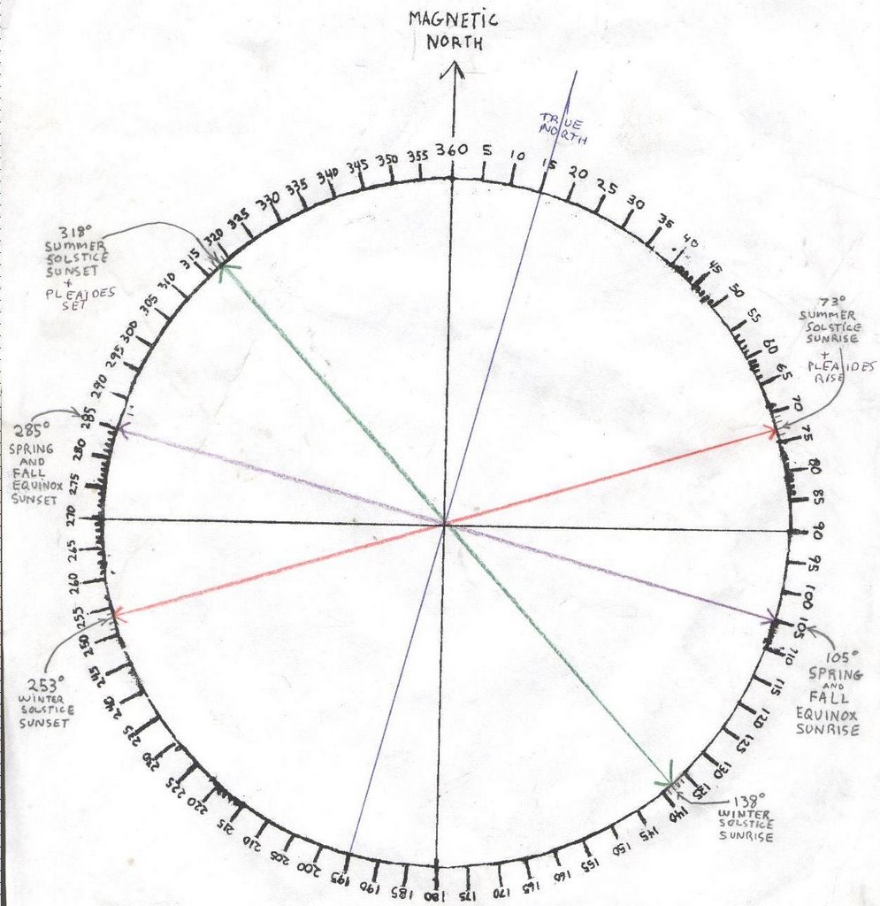
But I know that if I stand along a row of low stones (that are covered with snow and ice right now), right behind the original location of a boulder that Jamie the banjo player knocked out of the path, mowing for a fox hunt club many years ago, I’d see the sunset directly above another boulder about 95 feet away.
And maybe, just before sunrise, looking at something called the "Stupid Sheet" I linked to from Rock Piles, I’d see the Pleiades set over the same stone that shows the Summer Solstice Sunset. I say maybe because I’ve never tried it and just noticed it said that at: http://photos1.blogger.com/blogger/1180/2122/1600/the_real_stupid_sheet.0.jpg . (Our numbers don't match up I know, but that magnetic North drifts about...)
More about Pleiades (Subaru in Japanese by the way, and hence the emblem on the front of the cars) here: http://en.wikipedia.org/wiki/Pleiades_(star_cluster).
(Did I say Hence? I’m not sure I’ve ever said that before, other than quoting someone.)
And when I find “The Delaware Big House Ceremony” by Frank Speck, I’ll re-read it and tell you if I am remembering correctly about these “seven special stars” that were first talking stones, then trees, and finally the stars…