Friday, September 30, 2011

‘Canada’ and the ‘United States’ Are in Turtle Island

By Steven T. Newcomb
September 30, 2011
"It is typical to refer to our respective nations and peoples as being “in” Canada or “in” the United States and therefore as being deemed subject to the jurisdictions of those two political constructs called “states” in international law. What we seldom express, however, is the more profound point that those two Western European political constructs are on and in Turtle Island, as North America is traditionally known to the Original Nations of Turtle Island..."


Steven Newcomb, Shawnee/Lenape, is co-founder and co-director of the Indigenous Law Institute, author of Pagans in the Promised Land: Decoding the Doctrine of Christian Discovery (Fulcrum, 2008), and a columnist for Indian Country Today Media Network.

Wednesday, September 28, 2011

Stylized Drawing of Fishweir (A Nutty Idea)

It's also a nutty idea in the sense that if one suggests an Indigenous origin for stonework in CT, one will be considered quite Nutty...

Tim Visel, in a draft of "Possible Construction Details of Stone/Wood Alewife Weirs In New England Tidal Streams; A Design Model Explanation  " (To accompany a recreation for the upcoming Hammonasset Festival, Oct 1-2, 2011 in Madison, CT) writes: "Some of the historical accounts describe the wing walls as gathering fish into baskets with the flow.  This is quite possible on the return to sea migration and this could include salmon and shad as well...It’s hard to evaluate the direction or movement of fish from many historical reports. They just mention how effective they were but it could provide some insight of non fishermen writing about what they observed.  To many it might seem the wing walls were guiding fish into the throat, the appearance of open arms and the downward flow...the heaps of stones remain – still holding the classic Vee shape after many centuries..."

And here’s another possibility:
In Folk Medicine of the Delaware and Related Algonkian Indians by Gladys Tantaquidgeon, Gladys lists on page 30.

"CHESTNUT (Aesculus glabra), “big acorn tree”: …Nuts are ground up for use as a fish poison in streams. This is known as “fish peyote” as it makes the fish "dizzy" and they can be caught easily.”

Gladys is using information taken from interviews with Delaware/Lenni Lenape people living in Oaklahoma in the 1920-30’s (I will look through Speck’s “Big House” because I seem to remember him mentioning it in there somewhere – she was his student/assisstant) and there’s an influence of other Native People, and the Wilson or Peyote Cult in the thoughts and language used by informants, and the “peyote” part comes from that, I infer. But then the downstream idea works well with “stunned” rather than actually “poisoned” fish.

Like California and Austrailian “fish poisons:”

“The active ingredient is released by mashing the appropriate plant parts, which are then introduced to the water environment. Poisoning was generally done in stagnant pools or slow-flowing streams and rivers, that allow the pounded bark, leaf, seed, root or fruit, to concentrate its power without being washed away or diluted by a strong current. Sometimes streams would be partly blocked to slow down the water flow. Gathering the fish was usually done by hand, but baskets, spears and nets were sometimes employed.”

From ‘Fishing with Poisons By Chuck Kritzon © 2003 http://www.primitiveways.com/fish_poison.html

Another source mentions these other "poisons."
Location or Tribe Common Name, (Latin Name) Part used
Catawba, Cherokee, and Delaware: Black Walnut (Juglans nigra) Bark and green nut husk
Yuchi and Creek: Devil's Shoestring, (Symphoricarpos orbiculatus) Roots, Horse Chestnut, (Aesculus hippocastanum L) Fruit, twigs and buds
Cherokee: Polk Sallet, Polkweed, (Phytolacca americana) Berries
Central and coastal California: Turkey-Mullein, (Eremocarpus setigerus) Leaves, California Buckeye, (Aesculus California) Nut or fruit, Soap plant, soap root, (Chlorogalum pomeridianum) Bulb, Pokeweed, Polk sallet, (Phytolacca americana) Leaves, Indian Turnip, (Arisaema triphyllum) Leaves, Wild cucumber, Manroot, ( Marah fabaceus) Seeds

Above from: http://www.rogueturtle.com/articles/fishx.php and there's more to be found at: http://www.survival.com/fish.htm


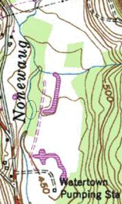
Above the diagonal weir at Nonnewaug in Woodbury, a smaller stream used to flow into the Nonnewaug. The area it comes from is where there was an early road from the nearby mill owned by the Minor’s and then Atwood’s, both families historically connected to my house built early in the 1700’s (possibly begun as early as 1700 or 1710), that leads uphill into the “mast forest” resource zone of the earlier Native American Cultural Landscape, the easiest route back down to the mill. This smaller stream has been redirected many times in the past and there still is mostly an oak forest along that old and abandoned road - and probably was the source of the hand hewn chestnut timbers and plank sheathing of my house, some of the planking showing signs of being “pit sawn” rather than milled. I’ve located a mortar in a “stone wall” that was probably a fire break around the forest and it makes sense to me that chestnuts could have been ground up there, placed in the stream to stun fish that flowed down into baskets on the downstream side of the stones and stakes of the weir.

Also, from personal experience with eels, I would imagine that a stunned eel is much easier to catch than a “regular” eel. Same goes for any other fish. What could be less labor intensive than having some stunned fish flow downstream into your waiting basket at a gap in any sort of fishweir and the Nonnewaug fishweir in particular?
Step by step details:
Offer some Tobacco at the Box Turtle Petroform, gather some Chestnuts (Black Walnuts and other plant materials too?) Place them in the small stream...

...walk down to the others gathered at the Fish Weir and prepare to smoke
and otherwise process some "dizzy" fish.

Added on 4/20/2023:


Saturday, September 24, 2011

Sleeping Buffalo Boulder (MT)

Legend grew up about the stone buffalo among the Gros Ventre along with similar stories found among the Assiniboine. These legends reflect the reverence in which all tribes held the stone.


According to the Gros Ventre story, the Indians during a time when the world was young, became greedy and cruel. It was a time of plenty, when living was too easy for the people. Now they knew that the buffalo had been placed on earth for the purpose of providing food, shelter and all other necessities and that for these things he must be honored. They were obsessed with a lust for killing and slaughtered the buffalo by the thousands. Meat was left to the wolves and coyotes, for their people were rich in meat and robes and had no need for more. They only cared to see their arrows strike quivering flesh and red blood gush forth upon the ground. Then there came a dream to a maiden of the tribe. In this dream the girl was told that unless the slaughter of the buffalo was stopped, the tribe and all others would hunger for many years for the taste of fat buffalo meat. The young woman went to the chief and told him of her dream. He laughed at her and continued with plans for a greater hunt than ever.

When the morning of the hunt dawned the young men appointed as scouts to locate the herds returned with word that there were no buffalo within a day's reach. The search widened and continued over a great distance for days and weeks and months. The supplies of dried meat became low, robes wore thin and teepees no longer kept out the wind, but still no buffalo were sighted.

Then one evening a scout came to the village with word that a small herd of buffalo had been seen near the Council Hill, four miles from what is now the Sleeping Buffalo Resort, at the crossing on the Milk River where the river turns to form the Big Bend. The most cunning hunters approached the place and saw quite plainly the herd of buffalo grazing on the slope of the hill. They waited until the animals had lain down and then crept closer for an attack. When the hunters were within arrow shot of the herd, they sprang up with a shout meaning to startle the buffalo to their feet so they could more surely be killed. But before their eyes a strange happening took place. The buffalo began to look less and less like living creatures and more like boulders scattered on the hillside. The frightened hunters went closer until they could touch what had been flesh but was now stone. The leader of the herd was there and the cows and calves, but all were stone.

The hunters returned to their village to report the strange happening. A council was called and it was remembered that a maiden of the tribe had dreamed a strange dream of the buffalo. She was brought before the chief medicine man and instructed to go to the place of the stone buffalo and fast there until her dream was made clear.

After three days and nights of fasting and prayer, the girl returned and told the people they had been punished for their cruelty and greediness and that henceforth, unless they killed only for the necessities of life, the buffalo and all other game would return no more to the hunting grounds. This was many generations ago and therefore the buffalo returned and became plentiful. But the people remembered the time of hunger and killed only for meat and for skins to make their lodges and robes.


http://malta.k12.mt.us/hs/historyprojects/sleepingbuffalo.pdf


Wednesday, September 21, 2011

Aerial and map Images of Nonnewaug Weir


(Above: Weir circled in white. Below: Weir circled in red ~1965)

Before (above) and (below) after the Bulldozers changed the contour lines:

Weir in center of image, appearing as light colored boulders on river bank, sometime before 2007. A facing west view can be found by clicking here: http://www.bing.com/maps/?v=2&cp=qy0x1f8x1zbz&lvl=19.509761358382203&dir=274.6620815808467&sty=b&form=LMLTCC

Fish Weir Village


"Site of fish weir across the Lemhi River where the Shoshone were able to trap enough Salmon for their subsistence and provide the (Lewis & Clark) expedition with as much broiled and dried salmon as they could eat, as well as dried chokecherries.

"...I went to see the place those people take the fish, a wear [weir] across the creek in which there is stuk baskets set in different derections so as to take the fish either descending or assending..." -- Clark, August 21, 1805

"...water was conducted to this basket, which was so narrow at it's lower extremity that the fish when once in could not turn itself about, and were taken out by untying the small ends of the longitudinal willows, which formed the hull of the basket." --Lewis, August 21, 1805
From: Salmon-Challis National Forest http://www.fs.fed.us/r4/sc/recreation/lewis-clark/maptext.shtml

Image from: "fishing weir – theater set" by Marie Lorenz
"A weir is a system of nets used to trap fish in current. This is a drawing that William Clark made of a fishing weir in Tower Creek, Idaho. In his journal, Captain Clark described the fishing weir, made by the Lemhi-Shoshone People to catch Salmon: “There were two distinct wears formed of poles and willow sticks, quite across the river, at no great distance from each other. Each of these, were furnished with two baskets; the one wear to take them ascending and the other in decending. In constructing these wears, poles were first tyed together in parcels of three near the smaller extremity; these were set on end, and spread in a triangular form at the base, in such manner, that two or the three poles ranged in the direction of the intended work, and the third down the stream. Two ranges of horizontal poles were next lashed with willow bark and wythes to the ranging poles, and on these willow ticks were placed perpendicularly, reaching from the bottom of the river to about 3 or four feet above it’s surface; and placed so near each other, as not to permit the passage of the fish.” http://www.tideandcurrenttaxi.org/?p=2384

Tuesday, September 20, 2011

A Macrobotanical Analysis

of Native American Maize Agriculture
 at the Smith's Point Site (on Cape Cod MA)
Graduate Masters Theses. Paper 8.
by Kelly A. Ferguson
August 2010

Typical sand dune plant communities on the Cape Cod seashore.

       "...European writers often did not credit Native Americans for actively shaping these landscapes. Alternatively, some researchers have argued that the role of Native Americans in creating the Late Woodland-Early Colonial landscape in New England was consciously downplayed or omitted from 16th and 17th century European documentary accounts as means of pro-colonial rhetoric (Bragdon 1996; Calloway 1997)...Additionally, while lightning fires burn indiscriminately, uncharred 17th- century artifacts and shell from the living area of the site may indicate that this area of the site was not burned (PAL 1991). Therefore, it is possible that the field area was selectively burned by Native American inhabitants and represents cultural burning at the site."

Nonnewaug Fishweir Photos; A Stake at a Fishweir at Stake


The most intact part of the weir; a human construction of boulders about four feet long and two or three feet wide, more or less.
The lower, down-river, end of the weir (above) was relatively intact and partially buried in 1997 (below). 
By some strange twist of fate, as the saying goes, this person's left foot is very close to a large flat boulder which was moved by the flooding that occurred from Hurricane Irene at the end of August 2011 (as well as a water release at a dam upstream prior to the storm). 
Protruding from the present river bed about 14cm (about 5 and a half inches) is a piece of wood that could possibly be either a piece of driftwood that just happened to lodge there naturally or a wooden stake that was inserted there by human hands as part of a working fishweir at some point in time. You could say it is either a "stick" or a "stake." 
The stake or stick is angeled toward the way water at one time I suspect flowed...
Two cobbles were moved during the flooding, I suspect, while the boulder, the possible stake and another cobble remained relatively intact, more or less still in the diagonal line of boulders and cobbles of the stones used to construct the weir. There are a few more "human enhancements" to the weir, two drill holes in two different boulders:


The word "Nonnewaug" was translated by Woodbury Historian William Cothren as "The Fresh Water Fishing Place." I suspect the "Nonne" part of the Algonquian compound word means "in the middle," attached to the "waug' which often means "fishing place," which a weir certainly would be. Cothren also recorded, as the "land deeds' or treaties do as well, that the Nonnewaug Wigwams were inhabited in 1659 and up to and perhaps after 1700-10. Cothren interperted Nonnewaug's signature to be a snowshoe, while I believe Nonnewaug (or Nunawauk as above) used a picto graph of perhaps an eel basket for his representation of his title as "Sachem Nonnewaug" or "The Keeper of the Peace at the Freshwater Fishing Place (Weir) in the Middle."
Above: a David Wagner painting of Native Americans at a stone fishweir with wooden stakes during the fall migration of eels, capturing eels in baskets.
And after all that, it turns out to be a stick:
On Sept. 21, 2011, I wiggled it, moved some small stones, and wiggled it again. It came out very easily and looks like an unremarkable sycamore stick.

A Few Downed Trees

A few downed trees fell by the stone mounds in back of my old falling down chicken house sometime during Hurricane Irene. These photos are dated 09/12/2011...

This turtle's carapace was definately not "rolled" by the recent earthquake
and you can tell because it is "gathering moss," as they say...


Sunday, September 18, 2011

Nonnewaug Fishweir 9/17/2011


In the video: Hurricane Irene flooding has further damaged the weir and possibly exposed a wooden stake.

Hurricane Irene damage (the Water Company also released water before the storm which may have also caused damage) further deteriorated the weir. Note the drill holes and, at the downriver end, toward the end of the video, a possible wooden stake between stones...


"Weirs were described in 1634 by the Jesuits as ingeniously made, long and broad and capable of holding five or six hundred eels and having collected stones extending out on either side like a chain or little wall to direct to eels (Thwaites 1896-1901:6:309)."
 Otonabee Pimizi, American eel (Anguilla rostrata) on the Journey to “The Land Between”
by William Arthur Allen


“Land Between” Research Forum Peterborough, Ontario June 7, 2007

Saturday, September 17, 2011

Glooskap and the Frog

In the dark of the October New Moon, eels migrate toward the Sagasso Sea; in the past into baskets at fishweirs; today into hydro-electric turbines...
See:
http://glooskapandthefrog.org/eel%20challenge.htm

A prehistoric clam garden


“They took the largest rocks that were in the clam bed and moved them out to extreme low water marks, setting them in rows like a fence along the edge of the water...”

http://chriscorrigan.com/parkinglot/?p=309

Friday, September 16, 2011

Sucarnoochee River Fishweir

Porterville vicinity, Kemper County

"Fishweir technology has been documented over most of North America and the design principles and construction techniques are derived from an historical continuum dating back thousands of years. Largely unchanged over time, the basic design is a V-shaped dam with an opening for a trap at the downstream apex. The function is unchanged as well, mass procurement of food. The Sucarnoochee River Fishweir represents one of the better preserved fishdams found in Mississippi and is exemplary of the style and construction techniques used throughout history. Fishweirs are disappearing due to such modern practices as stream channelization, along with natural erosion, silting and channel displacement. The Sucarnoochee River Fishweir was listed on March 10, 2010. John Connaway, MDAH staff archaeologist, wrote the nomination."

http://misspreservation.com/2010/12/30/national-register-listings-2010/


Pre-Columbian Fish Farming in the Amazon

by Clark L. Erickson, PhD

Article published in Expedition 43(3):7-8 (2001).

“One artificial feature, referred to as a zigzag earthwork, particularly intrigued me. Low earthen walls zigzag across the savannas between forest islands (Fig. 2). Because of their changing orientations, they did not make sense as roads between settlements. As we mapped them with tape measure and compass, I noted that there were small funnel like opening where the earthworks changed direction. I immediately realized that these matched the description of fish weirs that are reported in the ethnographic and historical literature on Amazonian peoples. Fish weirs are fences made of wood, brush, basketry, or stones with small openings that extend across bodies of water. Baskets or nets are placed in the openings to trap migrating fish. While most fish weirs are simple ephemeral structures crossing a river or shallow lake, those of Baures are permanent earthen features covering more than 500 square kilometers. In addition, small artificial ponds are associated with the fish weirs (Fig. 3). Today these ponds are filled with fish as the floodwaters recede in the dry season. I believe that in the past these were used to store live fish until needed. Our studies show that the weirs were used before the arrival of Europeans to the region.
The scale of the fish weir complex is larger than any previously reported. The native peoples of Baures shaped the environment into a productive landscape capable of providing sufficient protein to sustain large populations. The people responsible for this impressive land management are long gone or have forgotten the technology. Archaeology provides the only means of documenting this important lost knowledge. As politicians, conservationists, and aid agencies seek sustainable solutions to both develop and conserve the Amazon, archaeologists can play a key role by providing time-tested models of land use.
Fig. 2: Remains of fish weir (lower left to upper right) and fish ponds
(circular features surrounded by palms) from the air.

http://ccat.sas.upenn.edu/~cerickso/fishweir/articles/Expedition2.htm

Wednesday, September 14, 2011

Nice Photos of Stone Fish Traps

"Incidentally, for an earlier, wider scope take on subsistence and settlement and fish traps on the central coast, you can also download John Pomeroy’s 1980 PhD thesis ."
Again from: http://qmackie.wordpress.com/2009/10/22/dspace-elroy-white-xanius-on-fishtraps/
Actually, there's many nice photos through out the thesis. The Stone Fish Traps are discussed on page 103.

PDF: http://summit.sfu.ca/item/3334

Monday, September 12, 2011

Heiltsuk stone fish traps: Products of my ancestors' labour

Author: White (Xanius), Elroy Date created: 2006


Abstract:

This thesis presents the results of systematic research on Heiltsuk stone fish traps, which are poorly understood in academia. My research objective is unique in that I de-emphasize empirical data such as length, width, and height in favour of the view that these stone fish trap are products of my ancestors’ labour. My main goal was to work with the Heiltsuk political and cultural entities and 12 Heiltsuk oral historians to employ an Internalist archaeology investigation of a selective fishery system that began in antiquity. I linked oral history to ethnographic narratives about this ancient fishing technology. Using a novel method of videography, I captured 42 trap sites on video in order to become familiar with their locations, variations and their correlations of salmon to streams and rivers where a stone fish trap is found. I returned in August 2005 to map nine of them, especially the ones familiar to Heiltsuk oral historians.

Description:

The author has placed restrictions on the PDF copy of this thesis. The PDF is not printable nor copyable. If you would like the SFU Library to attempt to contact the author to get permission to print a copy, please email your request to thesis@sfu.ca.

You can find the link to the pdf and read it here:
http://summit.sfu.ca/item/4240 and if or when you do, please count the number of times he writes “stone wall” because I lost count early on when I tried to copy pieces of it anyway~ Tim

Hunters and gatherers? – not a chance!

 ‘Using the rhythm of nature to feed our people’
(Author's name not given)


“Dr Dana Lepofsky, one of the SFU project directors, said that the work so far “gives us a huge amount of respect and awe for the technologies and people of the past… “There was clearly a large population living off the land and sea in a sustained way,” Lepofsky said. “Sometimes resources were hit, but it was clearly a sustainable economy.

“People were harvesting with local observations and had a vested interest.

They knew that if you over-harvest, then there is not going to be food for next year. “We see things like people choosing among different resources. If they got a lot of a resource early in the season, they might take less of another one. They would do this ‘dance to the season’.

…the stone alignments that exist in the inter-tidal zones along the coast were not necessarily use for just one resource or just one purpose. Lepofsky said that phrases like ‘fish traps’ and ‘clam gardens’ are something of a misnomer. They could have been holding ponds for fish stock, traps for harvesting or places to cultivate and manage shellfish. They often were used for many purposes and not necessarily just one resource. It’s a pretty powerful story about long-term use that by definition was sustainable.”

http://www.sliammonfirstnation.com/archaeology/huntersandgatherers.pdf
What are Clam Gardens?
"A “clam garden” or “wuwuthim” in Tla’amin language, is a natural clam beach that has been cleared of rocks and terraced with a rock wall to increase clam production. The wall acts as a barrier for sand to build up against,to create a longer flat area of shallow water...These rock walls could be anywhere in size from 0.5 to 2 metres tall, and span many kilometres along the shoreline. By extending the beach flat seaward and clearing the beach of large cobbles, clam gardens create more suitable habitat or living space for clams."
http://www.sliammonfirstnation.com/archaeology/clams2.html
"Although never “lost” to First Nations knowledge keepers, clam gardens have only been relatively recently “discovered” by non-native Northwest Coast scholars who viewed them as either natural rock structures, or structures for another purpose. Dr. John Harper, a geologist, and Judith Williams, an artist, began separate investigations into these rock structures in the early 1990s, but it was not until each of them met with First Nations elders, knowledge keepers, and other long time coastal residents, that the academic’s mystery about these structures was “solved.”"
http://www.sliammonfirstnation.com/archaeology/clams4.html
Fish Traps
(One of many images of Stone Fish Traps to be found at the link below)

"Many peoples living on the Northwest Coast, including the Tla’amin, built large structures out of wood or stone in the intertidal zone and at the mouths of rivers to catch fish. These structures are commonly known as fish traps, and their remains can be seen in many places throughout Tla’amin traditional territory..."

http://www.sliammonfirstnation.com/archaeology/fishtrap.html

The Edible Seascape

When the tide is out, the table is set.—Tlingit proverb


Archeology ~ Volume 64 Number 5, September/October 2011
A reevaluation of evidence along North America’s western coast shows how its earliest inhabitants managed the sea’s resources
by Jude Isabella
At Gibsons Beach stone walls forming circles and other shapes serve as evidence that early peoples cultivated the intertidal zones to build clam gardens and fish traps.(Photo: Jude Isabella)

"The tide is going out at Gibsons Beach, in the Strait of Georgia on Canada’s west coast. When the tide is low, it’s easy to spot rock walls in the intertidal zone, the area of shore land that’s exposed during low tide and hidden when the tide is in. A person can look at this beach for years and never understand that apparently random scatterings of piled rocks were actually carefully constructed to catch food from the sea. One formation, a circular shape almost 100 feet in diameter, is a clam garden, a flattened area that pools water and creates a habitat for clams to grow. Nearby, also in the intertidal zone, is a chevron-shaped collection of stones that opens into the sea and funnels fish toward the shore, a fish trap.

Dana Lepofsky, an archaeologist at Simon Fraser University in Vancouver, British Columbia, believes these gardens and traps, found up and down the coast, could be up to 2,000 years old. They were used by the indigenous population and serve as artifacts that dispute what the archaeological record has to this point claimed was the area’s primary staple: salmon...“It’s hard to believe that Native Americans, who were keen observers of the natural world, didn’t figure out management techniques,” says Jon Erlandson, an archaeologist at the University of Oregon. He and his team collected reams of data from a large range of sites and species and concluded that, for example, a noticeable jump in the size of mussel shells didn’t appear to be simply the result of natural fluctuations in local environments. “Native peoples were generally in it for the long haul and developed more sustainable practices over time,” he explains...In almost every estuary that’s been scoured in the region, archaeologists have turned up evidence of wooden or stone fish traps. They’ve also uncovered clam gardens, which were an unknown technology to archaeologists until a geomorphologist on an aerial survey of the coast in 1995 identified the rock formations as made by humans..."
http://www.archaeology.org/1109/features/coast_salish_clam_gardens_salmon.html

Stone Plummets or stone fishing weights

“Stone plummets are thought to be the equivalent of modern day fishing weights. They were used during the Late Archaic period between 6,000 and 3,500 years ago…” http://seacoastnh.com/history/prehistoric/plummet1.html


“Contrary to articles published about stone fishing weights, I doubt that these were used to weight the bottom of the haul seines. These “sinkers” were too valuable to waste on a seine when it could tear or break at any instant. The time required to equip a seine would be extensive, and currents and tides could destroy the trap during a heavy and sudden storm. It appears they were used in the hand line cod fishing off Black Point, Niantic, according to some oral history accounts of shell fishermen there. I propose that weight was added by using quahog clamshells, holed and then strung on a vine or rope. When incorporated into a haul seine, the shells could clink along the bottom adding more background noise to scare fish further into the trap; simple and quick, yet very similar to the rubber disc sweeps on modern trawls. …(Timothy Visel - Evidence of Native American Brush Fish Weirs In South Cove, Old Saybrook, CT )”
http://www.soundschool.com/fishweirpaper.pdf

Oyster shell with hole collected 08/23/2011 from “Chaffinch Island in Guilford, which today contains a stonewall that resembles a vee trap (ibid).” Visel also writes that a habitat association exists between flounder and oysters and the presence of a device that traps fish on the ebbing tide.

"Unfortunately, little remains of these weirs today. The netting would quickly rot and marine worms could destroy a four-inch hickory pole in one summer. What remain are the stones, walls and enclosures that survived in protected areas along Connecticut’s coast.

Almost every feature of brush fykes and even the larger full tide traps used stones to help anchor the trap or its leader. They could be dragged to the shore and raft deployed to set them in place. I do not feel they were carried into place; having built fish pools for trout walking on soft mucky bottom, carrying rocks is less than rewarding under such conditions. Considering the amount of stones often used, it could represent decades of building or re-building. The leader would be placed first and rocks dumped on either side. If this were the case, leaders would need to move as driving stakes through last year’s stone piles would not work that well. At low tide, these submersed stonewalls would function more as a fence or barrier, assisting the final capture of fish on the ebbing tide...Several references shed information on the type of materials used to construct these weirs. The primary materials were stone and wood, secondary vines and rocks and twines mesh. Therefore, only stones remain today as evidence of these early fisheries. Chaffinch Island, a public park in Guilford, CT, shares a similar feature – a stonefish weir from a headland. Here a similar bowl coastal feature directed fish much in the same way. In South Cove, in Old Saybrook, at the northeast corner of this bowl, a pronounced stonewall protrudes to create a Vtrap. The amount of stones used was tremendous, and some assemblage is clearly visible on satellite imaging in the areas of the headland..."

"At the lowest tide, the rocks could be exposed and function like a stonewall fence, which basically it was." ~ Tim Visel