Showing posts sorted by date for query lost lake. Sort by relevance Show all posts

Saturday, November 11, 2023

A Developing Situation (Watertown CT)


3 X's mark the spot slated for development...
I knew the place well, once a neighbor's farm, 
A short walk from my parents' house,
A place of wonder both back then and now...

I first learned to read the landscape there,
Fields and wetlands and of course stonewalls,
Bedrock outcrops and farm junk and of course stonewalls,
Earthen dams and wildlife,
Turtles and Herons and Beavers,
And of course stonewalls...

Especially if they were "zigzag stonewalls:" 


Flickr Album "Lost Lake" Collection:

By 2008, I'd unlearned  a certain bias against the thought that all "stonewalls" were of post contact origin and that a zigzag row of stones might not be an accidental construction of field clearing stones thrown up against a Snake or Virginia Rail fence made of wood...


Zigzags and linear stone rows on a LiDar image,
Some are quite massive and are easily seen, 
While some others don't show all that well,
Especially those bordering former Indigenous "wetland gardens"...

This photo below was taken facing north/north northwest,
A probable Snake Effigy on the outcrop behind it:

The Distribution Center would obliterate the Indigenous Stonework Effigy:


Another spot along the massive row of stacked stones,
Qusukqaniyutôk, a ‘stone row, enclosure’ Harris and Robinson, 2015:140, ‘fence that crosses back’ viz. qussuk, ‘stone,’ Nipmuc or quski, quskaca, ‘returning, crosses over,’ qaqi, ‘runs,’ pumiyotôk, ‘fence, wall,’ Mohegan, Mohegan Nation 2004:145, 95, 129) wall (outdoor), fence, NI – pumiyotôk plural pumiyotôkansh.) - Nohham Rolf Cachat-Schilling

Bulletin of the Massachusetts Archaeological Society, Vol. 77, No. 2 Fall 2016

https://vc.bridgew.edu/cgi/viewcontent.cgi?article=1202&context=bmas

Stones stacked on a boulder,
A "Stone Prayer," 
A káhtôquwuk:
A kind of stone pile,
Or a stone heap,
 something that is heaped high,
 ceremonially,
 religiously, 
by placing one stone above another stone, 
“Invested with prayers for the balance of the universe.”

http://wakinguponturtleisland.blogspot.com/2022/03/kahtoquwuk-stone-prayers.html

I'm pretty sure that this "site" is included in the Nonnewaug or CT Cluster #3

in Dr. Curtiss Hoffman's inventory of suspected Indigenous Stone Constructions:


I'm not a Tribal Historic Preservation Officer
and can't give this an official designation as a
Ceremonial Stone Landscape site
but I'm very reasonably certain that it is...


Possibly, a Turtle Effigy:

A smaller Snake or Great Serpent Effigy:

An overlay with an eye and some horns:


  Certain features, such as the linked outcrops and boulders etc., are reminiscent of features found in the Oley hills of PA, some of which are quite possibly thousands of years old, once thought to be "colonial or post colonial field clearing stones:" 

"More than 5000 rock structure sites are found in northeastern United States, but their cultural attribution has long been debated. Some argue than many are prehistoric in origin, while others maintain they all date to colonial times. Few have been dated, and of those that have, the association of the dated material and the rocks can be challenged. Here, we provide luminescence analysis on the rocks themselves at a large site in eastern Pennsylvania. Our results suggest an age coeval with the Adena culture of the Ohio Valley."

https://journals.sagepub.com/doi/10.1177/0197693120920492?icid=int.sj-abstract.similar-articles.3

Added Monday, December 04, 2023

To the Watertown CT Planning and Zoning Commission:

   My name is Tim MacSweeney, a former Watertown Resident from 1956 to 1974 who has spent a great deal of time exploring the stone walls, trails, ponds, fields, and woodlands of the Panilaitis Farm, now a proposed site of development that includes a 767,000 sq. ft. distribution center and 150 units of residential housing.

  In 1990, I became interested in what has since become known as Native American Ceremonial Stone Landscapes and have spent the last 33 years as an Independent Researcher of these types of Cultural Landscapes. My particular area of study is the stacked stone structures that are often misidentified as “Yankee Farmer’s Stone Walls.” It was in fact on the property in question, the former Paniliatis Farm, that I first observed what are known as Zig-zag stone walls, conjectured to be remnants of colonial agriculture, the stone remains of field clearing stones tossed against wooden Virginia Rail Fences that have since decomposed, an idea popularized by the artist and writer Eric Sloane in the 1950s.

  In recent years, similar stone constructions, also long believed to be related to farming by European Americans over the last 400 years, have proven to be far older. One such Ceremonial Stone Landscape in Pennsylvania has been dated by a process known as Optically Stimulated Luminescence to 500 B.C. according to a study by James Feathers and my friend Norman Muller.

https://journals.sagepub.com/doi/10.1177/0197693120920492?icid=int.sj-abstract.similar-articles.3

  Another site in Massachusetts appears to be about 3,595 years old, according to a study by Shannon Mahan of the Geosciences and Environmental Change Science Center.

https://www.usgs.gov/data/optically-stimulated-luminescence-osl-data-and-ages-selected-native-american-sacred-ceremonial

  On the landscape that was the former Paniliatis Farm, these rows of stones border the wetlands, pass over out crops of bedrock, and sometimes become linear rows of stones, all characteristics that are very similar those found in the sites in PA and MA, as well as at a Preserve in Hopkinton, Rhode Island whose age is in the range of 1570-1490 C.E (or 490 ± 40 years ago).

 I'm neither a credentialed Anthropologist/Archaeologist nor a Tribal Historic Preservation Officer and can't give this an official designation as a Ceremonial Stone Landscape site but I'm very reasonably certain that it is...

  My question to the committee would be:

Has an Archaeological Assessment been performed that includes consultation with Tribal Historic Preservation Offices regarding these irreplaceable Cultural Resources?

Sincerely,

Tim MacSweeney

timmacs@yahoo.com

29 Nonnewaug Road

Woodbury CT


Monday, January 31, 2022

Carbuncle -and Split Boulder?? (Rhode Island)


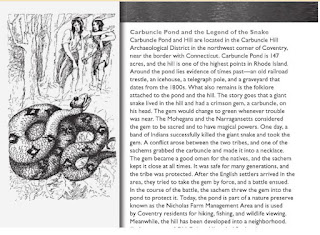
Carbuncle Pond

      “From Coventry comes the Legend of Carbuncle Pond. Years ago when that particular region was claimed by Narragansett and Mohegan alike, there lived on Carbuncle Hill a great snake. Its species was unknown, but its size was enormous and in the center of its head was a large gem — a carbuncle deep red, glowing with the brilliancy and radiance of a great fire. Whenever it moved about at night, its coming was announced by the glow of the gem, and even by day its light could be seen in a crimson flood in the darkness of the woods. Efforts of the Indians to capture the snake were unsuccessful until, shortly before the coming of the first white men, a large party of Indians surprised the reptile, and after a terrific battle killed it and secured the carbuncle. Tradition relates that at the scene of the battle a large rock was cleft in twain by the snake's tail. The carbuncle served the Indian tribe as a talisman and warning of danger for many years. When the white men came and heard the story of this wonderful gem, they longed to possess it and arranged an expedition against the Indians for that purpose. They attempted a surprise attack, but their advance was announced by the increased glow of the stone, and the Indians were prepared. After a battle which decimated the Indians, the chief alone was left standing; but when the white men tried to take the carbuncle from him he drew back his arm and gave it a mighty throw. It landed with a great splash in the middle of the pond and was lost forever.”

  1. Workers of the Federal Writers' Program of the Works Progress Administration for the State of Rhode Island, Rhode Island: A Guide to the Smallest State, American Guide Series, Riverside Press, Cambridge, Houghton Mifflin Company, Boston, 1937.

Rhode Island Folklore thesis 1956

     “Snakes, too, had a certain magic charm. Near the Connecticut line in what is now Coventry, a great snake once lived on Carbuncle Hill. Its species was unknown, but its size was enormous, and in the center of its head was a large gem--a carbuncle--deep red, glowing with the brilliancy and radiance of a great fire. Wherever it went at night, its presence was always announced by the glow of the gem, and even ln the daytime the light from the carbuncle could be seen in a crimson flood in the darkness of the woods. The Narragansetts and Mohegans, who had a mutual claim on this territory, tried to capture the great snake, but all efforts were unsuccessful until shortly before the coming of the first white man. A large party of Indians managed to surround the reptile and kill it; during the terrific battle, the snake cut a huge rock in two with one swipe of his tail. The carbuncle became the treasured talisman of the Indian tribe, and it served as a warning of danger for many years. When the white man carne and heard the s tory of this wonderful gem, they wanted to have it and arranged an expedition against the Indians to take it away. Since the settler's surprise attack was announced by the increased g low of the stone, the Indians were prepared. After the long, bitter battle, all the Indians were killed except the chief who stood alone with the carbuncle. When the white men tried to take the gem away from him, he drew back his arm and gave it a mighty throw. It landed with a great splash in the middle of a pond and was lost forever. Today that small lake is known as Carbuncle Pond.”  Pages 91-92

https://digitalcommons.uri.edu/cgi/viewcontent.cgi?article=1916&context=theses


"Stones on another map by the same guy, George E. Matteson:"

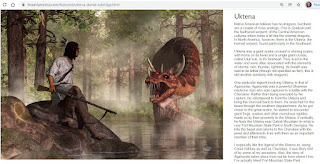
Mooney writes, "Those who know say that the Uktena is a great snake, as large around as a tree trunk, with horns on his head, and a bright, blazing crest like a diamond upon its forehead, and scales glittering like sparks of fire. It has rings or spots of color along its whole length, and can not be wounded except by shooting in the seventh spot from the head, because under this spot are its heart and its life. The blazing diamond is called Ulunsuti, "Transparent", and he who can win it may become the greatest wonder worker of the tribe, but it is worth a man's life to attempt it, for whoever is seen by the Uktena is so dazed by the bright light that he runs toward the snake instead of trying to escape.

 Even to see the Uktena asleep is death, not to the hunter himself, but to his family.

https://fineartamerica.com/featured/uktena-daniel-eskridge.html

     Of all the daring warriors who have started out in search of the Ulunsuti only Aganunitsi ever came back successful. The East Cherokee still keep the one which he brought. It is like a large transparent crystal, nearly the shape of a cartridge bullet, with a blood-red streak running through the center from top to bottom.. The owner keeps it wrapped in a whole deerskin, inside an earthen har hidden away in a secret cave in the mountains. Every seven days he feeds it with the blood of small game, rubbing the blood all over the crystal as soon as the animal has been killed. Twice a year it must have the blood of a deer or some other large animal. Should he forget to feed it at the proper time it would come out from its cave at night in a shape of fire and fly through the air to slake its thirst with the lifeblood of the conjurer or some one of his people. He may save himself from this danger by telling it, when he puts it away, the he will not need it again for a long time. It will then go quietly to sleep and feel no hunger until it is again brought out to be consulted. Then it must be fed again with blood before it is used.

 No white man must ever see it and no person but the owner will venture near it for fear of sudden death. Even the conjurer who keeps it is afraid of it, and changes its hiding place every once in a while so that it can not learn the way out. When he dies it will be buried with him. Otherwise it will come out of its cave, like a blazing star, to search for his grave, night after night for seven years, when if still not able to find him, it will go back to sleep forever where he has placed it.

 Whoever owns the Ulunsuti is sure of success in hunting, love, rain-making, and every other business, but its great use is in life prophecy. When it is consulted for this purpose the future is seen mirrored in the clear crystal as a tree is reflected in the quiet stream below, and the conjurer knows whether the sick man will recover, whether the warrior will return from battle, or whether the youth will live to be old."

   http://www.nativehistoryassociation.org/uktena_ulunsuti.php


“…the snake cut a huge rock in two with one swipe of his tail.”


Legendary Locals of Coventry

By Andrew D. Boisvert


Thursday, December 12, 2019

INDIAN NAMES OF PLACES IN WORCESTER COUNTY MASSACHUSETTS (Nipmuc)


WITH INTERPRETATIONS OF SOME OF THEM

By LINCOLN N. KINNICUTT WORCESTER, MASSACHUSETTS 1905

      Mr. Peter Whitney, in his history of the County of Worcester, in 1793, writes:

     "At Little Asnaconcomick pond there is every appearance that once a stone wall was built, or building, in some places it is two feet and a half in height, as if laid up by the hands of men." It has "the appearance of a large stone wall thrown down."

     I believe the name was first applied to the place where these stones are, rather than to either Great or Little Asnaconcomiok ponds, as there is nothing in this name referring to water, which is almost always the case in Indian names for ponds. I would suggest from Hassun a stone, quon, komuck, long house or long enclosed place; 'a long place enclosed with stones.'
     Little Asnaconcomiok pond is now known as Moosehorn pond. 


Asnebumskit, Hasnebumskitt.

      A large hill in Paxton and Holden, and a pond in Paxton. The pond taking the name from the hill, probably derived from Hassun, a stone, and ompsk, a standing rock, with the locative suffix, at or near, signifying 'the place where a large rock rises from stony ground.' At a prominent place on the hill this is a striking feature.
     In some old deeds the name is spelled Hasnebumskeat and Hasnebumskeag. It is generally called by the inhabitants “Bumskit,” which is an acknowledged corruption.

   The Indian deed of the township of Towtaid (Leicester) recorded March 8, 1713-14, but made the 27th of January, 1686, mentions this hill as one of the boundaries.

Hon. Emory Washburn, in his history of Leicester, says "The northern line (boundary) is assumed to be known by its running into a great hill called Aspomsok, which is supposed to be the hill now called Hasnebumskit in Paxton.
     The meaning of the name may be the same as Aspanoch, which Trumbull says is “perhaps the equivalent of Sehonach in Southampton, L. I., from Sipunnah, ground nuts, Indian potatoes," and formerly these plants were found in abundance in this vicinity, but I believe it is another form of expressing the same meaning as Hasnebumskit, both being corruptions of the same word, Hassun, a stone, ompsh, a standing rock, with the locative suffix.
        (See Asnebumskit.)


Augutteback.


     A pond in the western part of Oxford.
In the division of thirty thousand acres of the original grant of Oxford among five individuals ' ' Augutteback ' ' pond was the only permanent bound mentioned. All the others were marked trees, heaps of stones or stakes. This deed, dated July 3, 1698, was found m London in 1872, and is now in possession of the New York Hist. Soc. Cox copy is in the library of the Am. Anticq. Soc. in Worcester, and also printed in full in Amidown's Historical Collections, 1-128. Mr. Whitney gives the name “Augootsback,” but I can find no authority.
    I believe that this name is a corruption of Ahkuhq-paug or Aueuck-pag, ' Kettle pond, ' from the fact that many soapstone pots have been found in this vicinity, and a ledge or deposit of soapstone is still in existence, where many signs of Indian work have been discovered. From Ohkuk (Narr. Aucuck) (Cotton. Ohkuke) 'a pot or vessel.'


 Hassanamiset, Hassanamesitt, Hassanamisco, Hassunnimesut.

     The name of Grafton, near Worcester. Was one of the most important of the villages of the praying Indians. Gookin, in his "Historical Collections of the Indians in New England," written in 1674, says: "The name signifies a place of small stones," probably derived from Hassun, a stone; Haseunemes, a little stone, with the locative aifix, et or it. Hutchinson wrote the name " Hassunimesut " (Hist., vol. 1, p. 156).
James, the Printer, who was distinguished for his assistance in printing the Indian Bible, being employed in setting up the type, was a native of Hassanamiset. “A school was established here where the Bible was read and studied in the Indian language. Young men were here educated and sent into the neighboring towns to preach the Gospel as Christian teachers." (Mrs. Freeland's History of Oxford.)

Hassunnek.
A name sometimes given to an overhanging rock on Stone house hill in Holden, from which the hill takes its name. This name was never used by the Indians for this locality, but although modern is a literal translation.
Assinech (Hassunnek, Eliot), 'ledge of rocks.' Eliot used this word for any cave or den. 

    Hobbamoco was the Indian god of Evil, or Devil. In Wood's N. E. Prospect he is called Ahamocho (pt. 2, chap. 8). In many Indian legends his name occurs. In West Millbury there is a large upright flat rock called Hobbamoco's quoit, which by Indian tradition Hobbamoco attempted to throw from Wachusett mountain into Manchaug pond, and failed by about half a mile. The hill near the pond in Westborough was supposed to be one of his dwelling places.

    “There is another pond in Westborough which was called Hobbamocke, from some supposed infernal influence, which a man was unhappily under nigh that pond, from morning till the sun set" (Mass. Hist. Soc.'s Collections, series 2, vol. 10, p. 84).


Magomiscock.  

     The highest hill in Milford. The Indians gave the name probably to the whole range of hills. Mr. Ballou, in his history of Milford, says : " The name may be rendered, 'ground affording a grand show.' Its compounds appear to be Magko, to afford, give, or grant, misse, affording a grand prospect of the surrounding country." swollen, large, showy, grand, and ohke, earth, ground or place, literally, a high swell of land.
      I would suggest, however, that the base word of this name may be "Ompsk " (standing or upright rock), var. msk-msq ms, etc., and the name might be translated, ' Great Rock Country,' ' a place of great rocks.' Adin Ballou in his history speaks of the primitive ledges and the superabundance of various sized rocky fragments, preventing the profitable tillage of a considerable portion of the high lands (page 22). At the present day the quarries of Milford are celebrated.

Quassuck, Quassink.

Now Lead Mine pond in the western part of Sturbridge, mentioned in letter of William Pynchon to Stephen Day in 1644, "that place of Quassuck. " I should suppose the name was applied first to Lead Mine brook from its termination, "suck," which signifies "a stream flowing out of a pond or lake." (Trumbull.)

Quas-suck, the largest outlet. Possibly derived from Qussuk, with a lost locative suffix, et or ut, signifying, 'at the rock.' This was the Black Lead Mine property of which John Winthrop, Jr., eldest son of Gov. John Winthrop, received a grant from the General Court in 1644. The existence of this lead was known as early as thirteen years after the landing of the Pilgrims. (See Tantiusques.')
Possibly ' Pine tree brook, ' Cowawsuch.


Wallamanumpscook.
Mentioned as a boundary in Indian deed of Rutland, Dec. 22, 1686 (Middlesex Reg. of Deeds, libro 16, page 511, Apr. 14, 1714).
     This name is very similar to Wullamanick with the addition of ' ' umps ' ' and possibly may have designated 'a place where a rock rose from red paint ground' (see Wullamanick) ; ompsk, "standing or upright rock,” ock, ' ground' or ' place. '


Babaquamshk, Windham County - "split rock".
Peskeompscut, Franklin County - "at the split rocks".
Petacomscot, Petacomscott Petaqumskocte
"At the cleft rock; split boulder place"

Tattahassun, Worcester County - "at the top of the shaking or rocking boulder".

Wasapskotock, Hampden County - "at the shining rock".
Cheapschaddock, Cheeapschaddock, New London County - "big rocks at boundary place".
Chickons, Hampden County - "burned place (burned so as to be clear) ready for planting".
 Pesuponck         Name found throughout the region        Hot house (Indian sweatlodge)
Quassakonkanuck: Stone fence boundary mark; place at the stone wall


Thursday, February 01, 2018

Describing While Destroying an Indigenous Cultural Landscape (NY - 1779)

CONTINUATION OF NATHANIEL WEBB'S JOURNAL

As Published in the Elmira Republican of Sept. 11th and 12th, 1855.


Note—In the volume containing the "Journals of the Military Expedition of Major General John Sullivan against the Six Nations of Indians in 1779," prepared by Frederick Cook, Secretary of State, and published by the State in 1887, on page 285 et seq, is published part of the Journal of Nathaniel Webb, and a note says that a portion of the Journal cannot be found.
In a scrap-book originally kept by Thos. Maxwell, Esq., which was recently bought in an old book shop in New York, I find the missing Journal, and give herewith the portion supposed to be lost.
WILLIAM WAIT.
Note—In Col. Gansevoort's Journal of the same expedition, the entry is as follows:
"31st.—Decamped at 8 o'clock,—marched over mountainous ground until we arrived at the forks of Newtown—there entered on a low bottom, (Tuttle's flats), crossed the Kayuga branch, (Newtown creek), and encamped on a pine plain. Much good land about Newtown. Here we left the Tioga branch to our left."
September 1.—The army moved at 8 A. M. Several defiles and a large swamp occasioned our Brigade to encamp about three miles in the rear of the army. The army encamped that night at Catharine's town. The enemy had all fled from this town the night before and left an old squaw.
2.—Our brigade joined the army at Catharine's town. Lay the remaining part of the day for refreshment, &c.
3.—We destroyed some five fields of corn and decamped at 8 A. M. Marched this day about 11 miles. Encamped that night near the banks of the Seneca Lake. Marched this day through a remarkable country for timber.
4.—Decamped at 9 A. M. Burnt a small town on this day's march. Encamped at 7 P. M. The country still remains well timbered.
5.—Decamped at 10 A. M. Marched this day about six miles. Encamped that night at Conoyah, a beautiful town situated between the Seneca and Kengah lakes—distance between those lakes 8 miles. (Gansevoort writes it Kandaiah.)
6.—Lay in encampment. This town is beautifully situated in several respects—a fine level country—some fine fields of corn, a fine apple orchard, about twenty houses—situated about twenty miles from Seneca lake. One white man deserted from the enemy that had been taken prisoner last summer from Wyoming. Several horses were captured at this town. Decamped at 4 P. M., moved about 4 miles. Encamped in a beautiful piece of woods near the Lake. Col. Gansevoort, of our Brigade, was sent to destroy Kengah town joining Kengah lake, where they burnt several houses, got about twenty horses, &c.
7.—Decamped. Marched to Kanadesago, a town situated about three miles from the west end of the lake, the capital of the Senecas. (This was what is called the old Castle near Geneva.) Crossing the Seneca creek (or outlet) and several large defiles occasioned our not arriving in town till some time in the evening. This town consists of about 60 houses. Several large fields of corn. We found a white male child the enemy had left behind.
8.—The army was employed in destroying corn, beans, fruit trees, &c. A detachment sent to destroy a town about 12 miles from this town. (This was Cashong, Kashonguash, on the west side of the Seneca.)
9.—All the sick and lame sent to Tioga. At 11 A. M. we marched, following the road that leads to Niagara. Marched about 13 miles. Encamped near a brook that night.
10.—Decamped at 6 A. M. Marched this day about 13 miles—part of the day through a swampy country, abounding chiefly in beech and maple, some remarkably large white ash trees—latter part of the day through a grassy country. Passed the end of Connandockque lake. Encamped near some fine fields of corn. This town contains about 20 houses.
11.—Decamped at 4 A. M., after destroying the town and vegetables, &c. Marched this day to Hannayouya (Honeoye). This town is situated at the end of a small Lake of the same name—contains about 15 houses—a large flat of excellent land.
12.—The provisions and superfluous baggage of the army were left at this town, with a guard of about 200 men and two field pieces. The army decamped at 11 A. M. and marched towards the Genesee flats. Marched about 10 miles and encamped in the woods—passed this day a small lake called Konyoughojoh.
13.—Decamped at 6 A. M. Marched about two miles and halted at Adjustah. This town contains about 26 houses. While we halted at this town, Lieut. Boyd, with 20 men of the Rifle Corps, was sent to the next town to reconnoiter the enemy. On his return about 700 of the enemy ambushed him, killed and took 18 of the party. After the corn, &c., was destroyed and the town set in flames, we moved off to the next town. Our brigade marched some miles around to gain the rear of the enemy, but as usual they had fled before us. This town contains about 18 houses, situated at the southern end of the Genesee flats, on the banks of a small river that leads into the Genesee river.
14.—9 A. M. the army decamped, passed the river, entered the Genesee flats. This flat is judged to contain near 6,000 acres. We passed the Genesee river. This river runs with a strong current out of a hilly country. Three miles below where we forded, is navigable to lake Ontario. We burnt a small town on the bank of the river and marched that night to Genesee castle. There the body of Lieut. Boyd and one man was found murdered in a barbarous manner, too horrid to mention. This town is the metropolis of that nation; contains about 140 houses. Some fine buildings in it; situated about 40 miles from Niagara, on the south side of the Genesee river. The soil is exceedingly rich for 10 or 12 miles along the river. In and about this town, it was judged there were 800 acres of corn, beans, and vegetables of every kind.
15.—The whole army was employed in destroying the corn, &c. Now the general having completed and fulfilled his orders, after destroying the corn and setting the town in flames, the army passed the river and encamped upon the flats. One woman and one child made their escape from the savages and came to us that evening.
16.—Lay by to destroy corn along the flats. Decamped at 10 A. M. Encamped at Aojuhtah.
17.—Decamped at gun firing. Encamped at Honeoye.
18.-Decamped at 10 A. M. that day to Canandaigua. Encamped on the east side of the Lake.
19.—Marched to Connadasago.
20.—A party of 900 men was detached under command of Col. Butler, to destroy the Kengah tribe, and a party of 100 men under command of Col. Gansevoort to destroy part of the Mohawk tribe. Decamped at 3 P. M. and encamped on the east side of Seneca Lake.
21.—A party of 100 men was detached under Col. Dearborn to destroy the towns on the west side of Kenkah lake. Decamped at 8 A. M., passed Candiah about three miles and encamped at 4 P. M.
22.—Decamped at 7 A. M. Encamped that night within seven miles of Catharine town.
24.—(23d.?) Decamped at 7 A. M., passed Catharine town and encamped near the Big Swamp that night.
24.—Decamped at 5 A. M., passed the swamp and halted some time for refreshment. Encamped that night at Fort Reed, where we met provisions and stores for the reception of the Army. Upon our arrival at this place, (now Elmira), 13 cannon were discharged from the fort and was returned from one of our pieces 15 times. The latter was discharged in the space of one minute and a half. Dried provisions, &c.
(Colonel Gansevoort's Journal notes the proceedings of this day as follows: "Passed the swamp so much dreaded from its badness, without any difficulty and arrived at the forks of Newtown, where Capt. Reed with a detachment of 200 men had thrown up a breastwork to guard some stores and cattle brought forward from Tioga for the army in case of necessity. Saluted by 13 rounds of cannon from the breast-work, which number we returned from our artillery.")
Fort Reed was on the west side of the Newtown creek and on the north bank of the Tioga, where the creek falls into the river. It was a breast-work and was surrounded by palisades including some three or four acres. The western line of palisades can be traced on the west side of the junction canal and on the east side of Water st., a little south of the Fair grounds. The Journal continues.
25.—All the loaded muskets in the army were discharged at 5 A. M. The army was drawn up in one line and fired three rounds per man. After the discharge of 13 cannon, for our new ally the King of Spain, several oxen were killed for the officers and men.
(Col. Gansevoort's Journal thus describes this affair: "25.—This morning the small arms of the whole army were discharged at 5 o'clock. The whole were drawn up in one line, with a field piece on the right of each brigade, to fire a feu de joie—1st. thirteen rounds of cannon; 2d. a running fire of musketry, from right to left—repeated twice. Fifty oxen were killed on this joyous occasion, one delivered to each Brigade and one to the Artillery and staff. This was done in consequence of Spain having declared war against Britain.")
26.—At 12 A. M., the party under command of Col. Dearborn came in after destroying a fine country on the west side of the Kengah Lake. They brought in two squaws with them.
27.—400 men under the command of Col. Courtland, was employed in destroying corn up the river. 30 boats arrived from Tioga.
28.—All the sick were sent to Tioga. The party under the command of Col. Butler, returned from destroying the Kengah tribe. They found a most beautiful country abounding in vast quantities of corn and vegetables of all kinds; the same party under command of Col. Courtland, was employed up the river; also, 500 men were employed down the river, towards Tioga, destroying corn and vegetables on the flats.
29.—Decamped 6 A. M. Encamped that night 3 miles below Chemung and within 3 miles of Tioga.
30.—Decamped at 6 A. M., arrived at Fort Sullivan at 1 P. M. Upon our arrival the garrison discharged 13 cannon and we returned the same. Pitched tents on the ground we occupied before.
October 3.—A party of 500 men turned out to load the boats and demolish Fort Sullivan. The army drew 6 days' flour to carry them to Wyoming.
4.—Decamped at 6 A. M. Passed the river and encamped that night within 5 miles of Standing Stone, near the river.
5.—All the cattle, stores and horses were sent down to Wyoming. The whole went on board the boats. The fleet got under way at 6 A. M.
6.—The fleet got under way at 9 A. M. Arrived at evening at Shawney Flats.
7.—The whole fleet got under way at 9 A. M., and arrived at Wyoming at 2 P. M. When it hove in sight 13 cannon were fired by the garrison and returned by the fleet. The army encamped near the garrison.
8.—Two hundred men were detached to repair the road from this post to Easton and to remain there until the army arrives.
10.—Gen. Sullivan set out for Easton, leaving the command to Gen. Clinton. Decamped at 11 A. M. Encamped that night at Bullock's tavern.
11.—The rear of the army came up to camp at 9 A. M. Marched this day and encamped between the Shades of Death and the Big Swamp.
12.—Decamped at 7 A. M. Encamped that night at the White Oak Run.
13.—Decamped at 8 o'clock in the morning. The army moved that day to Brink's Mills.
14.—Decamped at 10 A. M. Passed the Wind Gap and encamped that night within 12 miles of Easton.
15.—Decamped at 6 o'clock in the morning and arrived at Easton at 2 P. M. Encamped in the Forks of the Delaware on the bank of the Lehigh.
17.—Our Brigade mustered. The Rev. Parson Evans delivered a discourse to the army in the German church.
In the same volume is given a table of distances as traveled by the army from Easton to Genesee Castle, as surveyed by Mr. Lodge, Surveyor to the Western army:
From Easton to
Wyoming
 65
miles
"
Lackawanna
 75
"
"
Quelutinack
 82
"
"
Tunkhannock Creek
 93
"
"
Mesupin
102
"
"
Vanderlip's Farm
107
"
"
Wyalusing
115
"
"
Wysaching Creek
129-1/2
"
"
Tioga
145
"
"
Chemung
157
"
"
Forks at Newtown
165
"
"
French Catharines, or Evoquagah
183-1/2
"
"
Condiah, or Appleton
211
"
"
Outlet of Seneca Lake
222-1/2
"
"
Canadesaco, or Seneca Lake
226
"
"
Canandaigua
241-1/2
"
"
Honeoye
255
"
"
Adjustah
267-1/2
"
"
Gasagularah
274-1/2
"
"
Genesee Castle
280
"

The Project Gutenberg EBook of Proceedings of the New York Historical
Association [1906], by Various