Wednesday, October 25, 2023

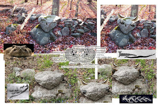
The White Deer Rocks Healing Diamond Stone


Changing plans, I turn down White Deer Rock Road.

It’s the “back side” of Lake Quassapaug, the Middlebury end

Not the Amusement Park side but the Tyler Cove side.

New stone walls by the country club entrance,

Formerly a road that my grandmother and her brothers would walk,

From the family farm, down to the Lake, to go fishing…

There’s no boat launch any more, no places to park on the Cove

But there are still some trails visible, leading up to where the Indian Fish Camp used to be.

Native people would camp there in the summer, they say,

From Waterbury and from Rhode Island and from all over, they say.

I assumed they meant “Long ago,” but I once talked with a Mr. Freeman

Who told me it wasn’t that long ago that he’d camp with his Grandmother

And other “Woodbury Indians.”

-          “But I just read a book that said there aren’t any more (Pootatuck) Woodbury Indians,” I say.

-          “Well my grandmother never must’ve read that book,” Mr. Freeman says.

Big new houses on the road but there’s Nature Center signs here and there along new pavement

And I stop at the designated parking spot a moment, look at the map and the broken rocky ground.

I realize that these outcrops were quarried, with probably blasting caps and dynamite;

I can see the old truck paths, softened with a hundred years’ worth of time,

Most likely back when Mr. Freeman’s father and his crew,

Just my Dad’s grandfather and his crew of a brother and a cousin,

Worked building the famous Whittemore estate walls in the WPA years…

-          Mr. Freeman tells me the story of the herd of White Deer that gave the road it’s name.

-          Almost word for word, it’s the same story my grandmother told me…


I spot a perched and pedestaled rhomboidal stone I had photographed years ago,

A Healing Diamond perhaps, a Medicine Stone,

And although I’ll never know just who did that

I start to understand the intention of the person who placed that Stone just so,

On the shattered remains of a Sacred Landscape…


http://wakinguponturtleisland.blogspot.com/2013/12/rhombus-stone-on-white-deer-rocks-road.html

https://wakinguponturtleisland.blogspot.com/2016/03/around-and-behind-rhomboidal-stone.html

Saturday, October 14, 2023

Decoding the Stones: Mike Luoma on New England's Hidden History

(Mike's original photo:)
   “In this episode, Mike Luoma shares his journey of discovery, visiting possible sacred stone sites and trying to unravel their meanings and histories. Whether you've stumbled upon mysterious stonework yourself or are just curious about the hidden history of New England, this book and our conversation with Mike offer eye-opening insights…”

Friday, October 13, 2023

More Excerpts from "Our Hidden Landscapes" (2023)


From the forward:


Some Distinguishing Characteristics:


For those peering through a tiny cell phone screen:


I have to admit that these photos took me by surprise:


Thursday, October 12, 2023

Old Baird Road Zig-zags

 Watertown CT Historian Charlie Crowell writes, “Here’s an old “zig-zag” stone wall that runs along an abandoned section of the Old Baird Road (aka. “Old Middle Road”) in Watertown (CT). This wall, or “stone fence” as early settlers would have called it, dates back to colonial times...Ancient pieces of split rail fencing still rest on top of the wall. Barbed wire, which came much later, is also present.

 The Old Baird Road was part of a stagecoach route from New Haven to Albany. During the American Revolution, the route was used to transport wagon loads of military supplies, presumably headed to the Battle of Saratoga in 1777. Soldiers marched along with the supply wagons..."

[Lifted, with permission, from the widely read Watertown History Page by Charlie Crowell:

 https://www.facebook.com/p/Watertown-History-Page-by-Charlie-Crowell-100060847285557/]

  I'm going to suggest that this roadway, bordered by what remains of "rows of stacked stones" may have originally been an "Indian Trail" - or really an "Indigenous Highway," one of many "Native American Paths" that were used by early settler colonists that have since become modern roads. I'm going to suggest that there is Indigenous Iconography used in the stacking method of the "stone fence" that reveals it as a carefully constructed Ceremonial Stone Landscape feature rather than an accidental feature related to stones being tossed up against a the wooden rails of a "Snake Fence," as zig-zag stone fences were conjectured to have been formed, as suggested by Eric Sloane and other writers/historians:


  In recent years, the idea that Indigenous Peoples of northeastern North America (or Turtle Island, as it was known as for a long, long time) did not make "large scale" stone constructions has come into question, and may well prove to be a great fallacy. The "zig-zag stone fence" has always intrigued me and really was one of the features of what has come to be known as Ceremonial Stone Landscape that I can't help but critically observe, here in the Nonnewaug or CT Cluster #3 as Curtiss Hoffman calls it in his inventory of possible Indigenous Stone Constructions in his book, Stone Prayers (2016). I've searched in vain for an actual messy conglomeration of stones in zigzag manner that would suggest field or road clearing stones thrown up against early post contact era wooden rail "Snake" or "Worm" fences and to this date have only found carefully constructed zigzag rows of stones (see the numerous posts in this blog). The "landform signature" of these zigzag rows of stones on Old Baird Road on LiDar images is a "regular and even" shape all too often assumed to be a sign of a "farmer's wall" by many researchers both professional and avocational: 


  Ground checking the rows of stones, this "point" of a zigzag suggests that these may be Indigenous in nature, perhaps fuel breaks and protective barriers infused with the power of a Great Horned Serpent: 


Obscured by the remnants of the chestnut rails,
this may also be another Snake's head... 
The deeply eroded road bed is bordered by remnants of rows of stones:

This occurs in many places in Cluster #3, sometimes with rails present, but more often not:


My simple hypothesis is that the rails were added later,
 to satisfy a legal requirement of early post contact fence laws:


An example of a "zig-zag stone wall" that was casually dismissed as a "wall of no great importance," in the Nonnewaug floodplain, destroyed by a road construction in 2007, aided by matching federal funding that should have warranted more research, ironically around the time the "Prayer Hill" site near Turners Falls was added to the National Historic Register as a Ceremonial Stone Landscape:


Qá qusuqaniyutôk nohkshô: “And the stone wall was broken.”

   Prov. 24:31, Mamusse Wunneetupanatamwe Up-Biblum God (“Eliot Indian Bible”)

https://paperzz.com/doc/8770750/rules-of-mohegan-grammar---mohegan-language-project


Old Baird Road:

Charles Crowell on the Flick site: https://www.flickr.com/photos/53003768@N06/

Wednesday, October 11, 2023

“So You Believe in Aliens Too?”


Chapter 5

Dr. Laurie W. Rush

 “So You Believe in Aliens Too?”

An Anthropologist Looks at Stone Features in the North American Northeast  and the Archaeologists Who Do and Do Not Study Them

https://uapress.arizona.edu/book/our-hidden-landscapes

 “No, I do not believe in aliens, nor do I believe that the people who inhabited the northeastern United States for more than 10,000 years never built anything out of stone.' It is equally incredible to me that farmers of European origin who only inhabited this same landscape for fewer than 500 years could be responsible for the construction of every single stone structure we encounter in the region today. What I also find hard to believe is how many archaeologists in the 21st century fail to apply robust scientific methodology to the analysis of stone features encountered every day in the landscapes of our region. This failure and the associated emotional responses to serious attempts at scientific discourse on the stone landscape issue beg for anthropological and historical analyses of the causes of this phenomenon, along with solutions for approaching more objective research in the future.” 

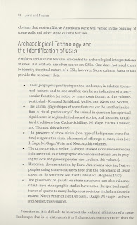
There are stone cultural features found throughout the landscapes of northeastern North America, and most archaeologists agree that these structures were created by people in the past. The controversy emerges when a new generation of archaeologists and people initiate objective research designed to conclusively determine the ancestry of these features. To accurately understand the true origins of the stone features of the Northeast, archaeologists of northeastern North America need to:


From:

Our Hidden Landscapes

Indigenous Stone Ceremonial Sites in Eastern North America

Lucianne Lavin (Editor), Elaine Thomas (Editor)

Foreword by Laurie Weinstein

Introduction by Lucianne Lavin and Elaine Thomas


Part I. Indigenous Perspectives on the Meaning and Significance of Ceremonial Stone Landscapes

1. When the Landscape Speaks for Itself, What Do We Learn? by Doug Harris

2. Markings of Ancestral Pathways: A Native Perspective by Elaine Thomas

3. Unseen Borders and Ways of Knowing: Northeastern Algonquian Sacred Lands by Nohham Rolf Cachat-Schilling

Part II. Academic Perspectives on Understanding, Protecting, and Preserving Indigenous Ceremonial Stone Landscapes

4. Obligations of Place: Engaging with Tribal Historic Preservation Offices in New England to Preserve and Protect Ceremonial Stone Landscapes by Paul A. Robinson

5. “So You Believe in Aliens, Too?” An Anthropologist Looks at Stone Features in the North American Northeast and the Archaeologists Who Do and Do Not Study Them by Laurie W. Rush

6. Introduction to Stone Removal and Disposal Practices in Agriculture and Farming by James E. Gage

7. Ceremonial Landscapes in the Chesapeake by Julia A. King and Scott M. Strickland

8. Stones and Their Places: An Application of Landscape Theory to Ceremonial Stone Landscapes of West Virginia by Matthew Victor Weiss and Charity Moore Norton

9. Piled Stone Features of Jackson County, Georgia by Johannes H. N. Loubser

Part III. Case Studies of Ceremonial Stone Landscapes

10. A Sacred Space on a Hilltop in Harwinton, Connecticut by Robert DeFosses

11. Interpreting Row-Linked Boulder Sites from Georgia to New England by Norman Muller

12. Historic Ceremonial Structures by Mary Gage

13. A Theoretical Model of the Moon and the Milky Way at Ancient Meeting Places by Frederick W. Martin

14. Mythologies of Light and Cast Shadow Within Northeastern Stone Chambers by Kathleen Patricia Thrane

Contributors
Nohham Rolf Cachat-Schilling
Robert DeFosses
James Gage
Mary Gage
Doug Harris
Julia A. King
Lucianne Lavin
Johannes (Jannie) H. N. Loubser
Frederick W. Martin
Norman Muller
Charity Moore Norton
Paul A. Robinson
Laurie W. Rush
Scott M. Strickland
Elaine Thomas
Kathleen Patricia Thrane
Matthew Victor Weiss

Monday, October 09, 2023

Our Hidden Landscapes: Indigenous Stone Ceremonial Sites in Southern New England


Our Hidden Landscapes: Indigenous Stone Ceremonial Sites in Southern New England

by Dr. Lucianne Lavin

Thursday, October 26, 2023

Harwinton Town Hall

100 Bentley Dr.

Harwinton, CT

Doors open at 6:30 pm

Presentation begins at 7:00 pm

Pre registration requested at this link.

Directions at this link.

Sponsored by the Harwinton and Burlington Land Trusts

​“A hike in the woods often reveals a variety of built stone cultural features. Many of these are the remains of abandoned farmsteads and industrial mill sites. Others, however, represent Native American ceremonial sites. The idea of Native Americans designing stone structures that represent sacred landscapes is fairly new to some Northeastern researchers, as it was historically – and erroneously -- thought that local Indigenous peoples did not build in stone and all such structures were the result of European-American farming activities. Some of it is, but some of it is not. 

​This PowerPoint presentation (and the recently published book on which it is based) introduces people to Southern New England’s Indigenous Ceremonial Stone Landscapes (CSLs) – sacred spaces whose principal identifying characteristics are stacked stone structures that cluster within specific physical landscapes. They are often unrecognized as the significant cultural landscapes they are, in dire need of protection and preservation.

​State regulations (in Connecticut, at least) support preservation of sacred Native American sites (that is, those sites of ritual significance), and so it is important for members of land trusts and conservation organizations, as well as private property owners, to be able to recognize these sites within their properties and work to preserve them.”

 https://www.burlingtonlandtrust.org/ramble2


Wednesday, October 04, 2023