2005 ESRARA ROCK ART CONFERENCE: AN INTERVIEW WITH JACK
STEINBRING
Tom Montag - May 10,
2005
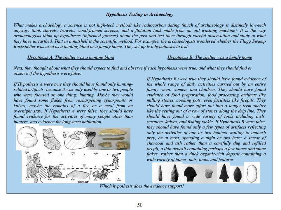
How do you define "rock art?"
Steinbring: Rock art is intentional imagery of some kind
placed on or made with rock. Leaving a mark is not confined to the human
species. Animals have markings too. When the marking is made by humans, they
use human attributes, notably their manual dexterity. The markings are first
only elemental marks, but these eventually become formalized and take shapes
not found in nature but in the mind and imagination of man. Why rock? Rock is
permanent; it will last for a long, long time. We see erosion taking place and
markings becoming obliterated over time. Yet in India we still see markings
that go back 300,000 years. Some assert that human markings can go back farther
than that. It becomes exceedingly complicated as time goes by.
Unfortunately, the image present in the mind of the public
is greatly conditioned by the cave art in Europe, which is spectacular, and
more attention was directed toward it at the beginning of interest in ancient
art. Now we call this "Euro-centric," meaning that judgments about
rock art are conditioned by the rock art of Europe, when in fact rock art
covers the globe. There are many areas around the world that have immensely
greater concentrations of rock art than Europe – for instance, Australia, South
Africa, and the southwestern United States.
How did you become interested in rock art?
Steinbring: Back about 1966 I was lecturing to an introductory
anthropology class at the University of Winnipeg and one of the students in the
class, who was also studying at the University of Manitoba, came up to me and
said, "We were flying over Whiteshell Forest Preserve [now Whiteshell
Provincial Park] and we think we found the ruins of an ancient city."
I thought to myself, "Yeah, you did."
"Bring me some pictures and if it is of interest, I'll
go take a look."
He brought in photos showing lines of boulders. They looked
intriguing. "Maybe you should go out and do a little mapping and
measuring," I said. He did. I was getting sold on the idea that there was
something there.
It turned out to be the Tie Creek site, the largest
petroform site in North America. It covers nine acres. It has seven interconnected
features, one of them over a hundred feet long. One has a bird shape, one is a
huge rectangle, there's a circle with a triangle in the middle, and a great
elliptical shape. These were obviously placed there by man, not by natural
agency.
First, we had to meticulously map the site. That took three
years. We did the first major study of the site, which was published in 1970.
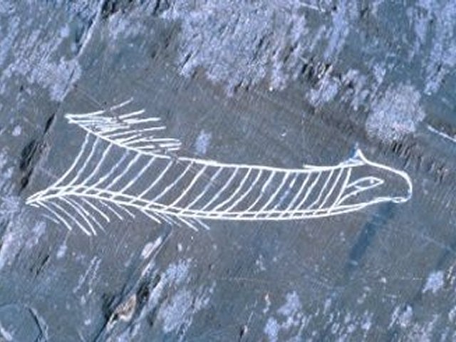
The question is: what is this? It's symbolic imagery. It has a shape that
precludes ordinary uses. It demonstrates a ceremonial or non-utilitarian
function, which puts it in the general category of art. In the American
southwest, images like this were already known. They were called
"geo-glyphs," big features imagined from a perspective of altitude.
They are best seen from above, which is why it is essential that you map them.
In the American southwest, they can go on for many hundreds of feet, made not
with boulders but by scratching away the desert varnish. The
"varnish" is due to the patination of particles on the surface. The
images in the American southwest were figures of humans and snakes and long
lines that could be visualized from the sky. The Tie Creek site was like that.
So my first experience with rock art was with petroforms.
In fact, the group that investigated the Tie Creek site
invented the term "petroform," specifically Dr. Peter Douglas Elias,
which is actually the fellow who called my attention to the site in the first
place. He got more and more interested in anthropology and eventually got a PhD
in the field. In the course of our work, we found out that a lot of people
already knew about the site.
I felt compelled to study the site because I was the only
anthropologist available who had training in both cultural anthropology and
archeology. The images were commonly thought to have been created by the
Ojibway. But we found evidence that the site was older than that.
The site was threatened by snowmobiles and tracked vehicles
fighting forest fires; the vehicles were dislodging boulders. We had evidence
that tracked vehicles had already disrupted lines…
Q. How would you explain rock art for today's busy and
somewhat material-minded Americans? Why is rock art important? What is its significance
to us? Why should we care about preserving it?
Steinbring: I don't think the stereotypically busy,
goal-driven, middle class American mind can be changed to appreciate the
ancient art of aboriginal America. We have to work indirectly to inspire
interest in these things, to educate people who are motivated to learn about
ancient art and its meaning. And we have to hope that these people can inspire
education that will promote a diversity of non-practical interests. In the
final analysis, everything we do, think, or say is dependent on education. If
people fail to take an interest in cultural things, it is because education has
failed. Education is everything.
Archeology is a lot like poetry – you can't drive it around
the block, you can't eat it. It's not utilitarian. You have to love it or leave
it alone. Everything I've done in my career has been intended to help people
overcome their lack of interest in things cultural. I'll still probably fail,
but it won't stop me.
How do we mark our sacred spaces - with
pictograph and petroform as earlier people did? Not exactly, though eons hence
perhaps someone will have to wonder over the lay of our rocks, the cast of our
bronze.
While the work is archeology and
anthropology- somewhat cold and disinterested - the task of understanding
sacred sites is also holy work and there is room in it for more than the
professional. There is room for poet and farmer and any and all of us who care
about these places.
(Also from Tom
Montag)
Tuesday, September 09,
2008
MORNING DRIVE
JOURNAL


