Wednesday, May 01, 2013

001 loose turtle island

    It just happens.
   Sometimes when downloading from the camera to the PC, the photos go to places you didn't intend them to go to, as if the computer felt like being a prankster. Or sometimes there simply were other photos on the camera, along with all those "rocks," and you didn't remember and you called the folder or set of photos "one week before memorial day" or "just some more falls summer pix " rather that the location of that stone (or the name you might have given the site or any sort of clue as to just where you were) that you just had to photograph, causing you to wonder "Where the ____ is that? Has somebody else been using the camera to take pictures of rocks? Have I convinced another family member that I'm not crazy?"
   That's how I ended up with a folder in my pictures on the computer that is labelled "001 loose turtle island."
Sometimes you get lucky and there is no doubt - "the universe sends you a sign," as they say:
(Sometimes two:)

Other times it takes a while before you remember this nice zigzag row is behind What's-his-name's House:
(It helps if the next photo contains a blurry image of What's-his-name's House:)

I am sure that when I captured this wonderful image below, my reading glasses were in a nice safe place miles away from where I was and the stone heap in the distance was in focus, as was the faint zigzag row behind the cobbles on the boulder:
I have a whole series of really interesting stone pile repeated patterns, design elements, ceremonial signatures of the Native American Cultural Landscape if you will, but the only in focus photo I got was this:
I may go back there - after I recall where it might be...
Sometimes I get all "Artsy:"
And then I cross the field I've crossed a half a million times (head down, looking carefully, walking slowly, never finding anything that even vaguely resembles an arrowhead once I bend down to pick it up)  and stop a little while to look at this low outcrop I've looked at a half a million times.
 I remember saying to whoever was with me, "Hey! A Medicine Bowlder!" and then try to remember just who was with me...
...and the next photo tells me just who was with me, 
just who I was talking to,
just who was agreeing with everything I was saying, 
"one week before memorial day:"

Tuesday, April 30, 2013

Heiltsuk Stone Fish Traps


http://youtu.be/jQlQO11cT-8

Wednesday, April 24, 2013

BadbadPotatoVisionvision

Copyright All rights reserved by badbadpotato

This morning, PWax reminded me to look at some photos on a Flickr Stream.
The one above was one of many that caught my eye - the Manitou shape (a lot like the "sugarloaf" shape of that chunk of Limestone from yesterday's post "Gitchie Manitou" here on Turtle Island).
And since it is somewhere on Turtle Island, I can't help but notice "the obvious turtle in the room/stone row."
Maybe that's a Bear's head, maybe that's a buzzard or some other bird as well and then I'm compelled to act on this compulsion to "doodle" on someone's perfectly good photograph...

There is no cure. 

badbadpotato's photostream:


Tuesday, April 23, 2013

Gitchi Manitou or Sugar Loaf Rock


Gitche Manitou (Gitchi Manitou, Kitchi Manitou, etc.) means "Great Spirit" in several Algonquian languages. The term was also utilized to signify God by Christian missionaries, when translating scriptures and prayers, etc. into the Algonquian languages.
Manitou is a common Algonquian term for spirit, mystery, or deity.
In more recent Anishinaabe culture, the Anishinaabe language word Gichi-manidoo means Great Spirit, the Creator of all things and the Giver of Life, and is sometimes translated as the "Great Mystery." Historically, Anishinaabe people believed in a variety of spirits, whose images were placed near doorways for protection.
According to Anishinaabe-Ojibwa tradition, what became known as Mackinac Island in Michigan was the home of Gitche Manitou. The people would make pilgrimages there for rituals devoted to the spirit… In addition to the Algonquian Anishinaabeg, many other tribes believed in Gitche Manitou. References to the Great Manitou by the Cheyenne and the Oglala Sioux (notably in the recollections of Black Elk), indicate that belief in this deity extended into the Great Plains, fully across the wider group of Algonquian peoples. {http://en.wikipedia.org/wiki/Gitche_Manitou}

Hand-tinted print of Gitchi Manitou, east side of Mackinac Island, by William H. Gardiner.
(No explaination of ladder given)

Sugar Loaf: Sugar Loaf is a dramatic breccia formation that rises 75 feet above the ground and is the largest of Mackinac Island’s many limestone stacks.  Centuries ago, Lake Algonquin covered all but the center of Mackinac Island, leaving only Sugar Loaf protruding from the water.  When the water receded, the rock formation remained standing as a tower of rock.  Ojibwe legend says that Sugar Loaf was the dwelling of the Great Creator or Great Spirit Gitchie Manitou.


 The Face of Gitchie Manitou in the Limestone:


Saturday, April 13, 2013

Archie Thompson


( Robert Gauthier, Los Angeles Times / January 17, 2013 )
Archie Thompson, pictured in January 2013, was the last of about 20 Yurok elders who helped revitalize the Yurok language over the last few decades, after academics in the 1990s predicted it would be extinct by 2010. Thompson died March 26 at age 93.
April 7, 2013

"Archie Thompson, the oldest living member of California's Yurok tribe and the last known active speaker raised in the tribal language, has died. He was 93..."
http://www.latimes.com/news/obituaries/la-me-archie-thompson-20130407,0,1929379.story
I ain't no geneologist or no geneologist's son, but there's a high degree of probability that he might have been related to Lucy Thompson:
http://wakinguponturtleisland.blogspot.com/2010/09/ms-lucy-says.html

Friday, April 12, 2013

"Dogs on Mounds"

 I have a new folder in my Turtle Island photos: "Dogs on Mounds."
I think these dogs are amateurs:


The Professionals:

"Initially used in police work,  forensic dogs were noted to alert on old cemeteries.  So the Institute of Canine Forensics, formed in 1997, began training working breeds—herding and hunting dogs—to locate ancient remains. 
Just How accurate are the dogs?   Extremely accurate, according to their handlers—who provide some impressive examples.
“On an archaeological site in Vacaville in June, the dogs identified burials that were 3,000 years old,” Grebenkemper said." 

http://www.eastcountymagazine.org/node/10446
In archaeology, an HHRD trained canine with impeccable manners, slow and methodical search style, properly trained and certified, may be the Remote Sensing Tool of the future. ICF canine trainers are "writing the book" in this field. Certification standards are high insuring that the ICF certified canines are reliable, non-invasive tools to be used in modern archaeology.
http://www.k9forensic.org/historical.html

The Law:
The Native American Graves Protection and Repatriation Act (NAGPRA), Pub. L. 101-601, 25 U.S.C. 3001 et seq., 104 Stat. 3048, is a United States federal law enacted on 16 November 1990. NAGPRA makes it a criminal offense to traffic in Native American human remains without right of possession or in Native American cultural items obtained in violation of the Act. Penalties for a first offense may reach 12 months imprisonment and a $100,000 fine.
http://en.wikipedia.org/wiki/Native_American_Graves_Protection_and_Repatriation_Act

The Other More Deadly Consequences of Disturbing Burials:

"When the state announced in the early 1980s that Route 55 - "the Road to Nowhere" - would finally be finished, a Nanticoke Leni-Lenape Indian chief warned that doing so would disturb the 8,000-year-old graves of his ancestors buried along the Almonesson Creek.
Sachem Wayandaga, an Indian chief and medicine man for the tribe, warned that if the burial ground were desecrated, "some very unusual things may occur at the site."
Some people just laughed....almost as soon as excavation began in March 1983, a bizarre series of accidents, injuries and illnesses befell people connected with the project. Most of the incidents involved the crew that worked for the John Rouse Construction Co.
The evening after the project began, the parents of one of the asphalt pavers were killed in a car accident. The brother and father of an office worker at the site died the same weekend.
John J. Cheli, owner of the excavation company that had cleared the land, died soon afterward, when his Corvette skidded off an icy road in Vineland.
No one at the site could figure out how crew member Leroy Starling ended up dead beneath the roller of an asphalt machine, or why a fierce gust of wind came up out of nowhere and knocked another worker off an overpass, paralyzing him.
Then there were the five crew members who narrowly escaped death when their van blew up and burst into flames as they rode from one section of the project to another.
Karl Kruger, who had been the Department of Transportation's site-engineering supervisor, confirmed the incidents. Kruger, who died several years ago, was a no-nonsense guy who claimed not to believe in ghosts or curses. He did say, however, that in the 25 years he had worked construction, he had never seen such an "unbelievable" amount of injury and loss on a job site.
An inspector working next to Kruger collapsed and died on the job after suffering a brain aneurysm. Other workers or members of their families were diagnosed with fast-moving cancers and other serious illnesses.
Some blamed the "curse" that supposedly occurred when the Indian burial grounds were unearthed. But Wayandaga insisted that no such curse existed and that the (multiple) tragedies were simply a result of disturbing the ancient graves..."

Monday, April 08, 2013

Megalithic similarities of Northern America and Northern Europe

Or: Мегалитические сооружения Северной Америки


Similarity megaliths, types, principles, systems of construction, accompanying designs
At the left - America (northeast  USA and Canada), on the right - northern Europe (Scandinavia and north Russia areas: Karelia, Lapland, Ural)
Similar megalithic consrtuction and structures are available on all northern hemisphere of the Earth.
 Base types of construction:
dolmen (tripod rock), perched boulders, rock-on-rock, twins-stones, split-wedged rock, cairn (platform, round), aligned boulder (small rock wall), stones boats (ships), stone piles, prayer seat, balanced rock, nishe, chamber... 
Landscape features:
stones and systems on rocks 
Systems of construction from boulders:
line, triangle, circle

http://perpettum.narod.ru/inaks.htm

What you find:

depends, mostly, on what you are looking for.
 Who is looking "Where" for "What?"
Map from "1493" by Charles Mann, inset from Curtiss Hoffman:

Mangled quote from John Lubbock, who actually is quoted as saying:
  "What we see depends mainly on what we look for."  
And the Turtles we see depends on the ones we look for (I said that):

Lubbock also said: 

Monday, April 01, 2013

Smoke in the Distance

Out in the distance, on the other side of the river from New Amsterdam on Manhattan Island, smoke rises. I can only assume it’s an Indian fire. Odd lines, much like stone walls, I can only assume, are barely visible. Perhaps they are fuel breaks made of stacked rows of stones…
Patches of forest and some open plains?
  Are there any other early drawings that show something like this?

And Roanke:
Nasuet:


And here's some early Vermonters not building stone but brush fences:


Sunday, March 31, 2013

Bill Gammage

"When European settlers arrived, argues author Bill Gammage, the indigenous people had for thousands of years used sophisticated local fire management to turn many areas in Australia into what these European migrants described over and over again as being very like an English gentleman’s park. Not national parks, mind you. By parks, they meant the carefully tended acres of the landed gentry’s country estates back home...The landscape in those colonial artworks, he writes, was not natural but man-made by indigenous Australians who knew which plants to burn, how hot to make their fires, when to light them — in the dry of summer or the cool, moist winters — and how to keep them under control. They also knew which areas not to burn. Their aim, he says, was to produce the distinctive templates of heavily treed areas neighbouring grasslands, ideal for attracting and ambushing game, like kangaroos.
In areas where indigenous people were dispossessed by European settlers and could no longer tend their land, the trees grew back. And an Australian wilderness began to be brought forth, just a few hundred years ago..." {http://www.theglobalmail.org/feature/australias-original-landscape-gardeners/371/ }.


For Bill Gammage, the whole project of The Biggest Estate on Earth started with a hunch caused by recognising anomalies between what he read and what he saw in the land around him. I can recommend a spot of gammaging in your own chosen landscape over the summer months, not perhaps as a typical holiday pastime, but as an activity that could transform mere scenery into the living cultural mosaic that is right before your eyes.

Read more: http://www.smh.com.au/entertainment/art-and-design/through-the-prism-of-ancient-practice-20130104-2c83i.html#ixzz2P9BSw9Wr
And:

Another Turtle Island

Like Stonehenge (with a road thru it)

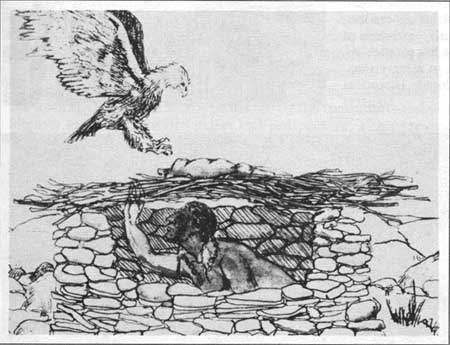
Eagle Traps

(I don't know why the text below that accompanies this drawing doesn't read: "It was common for Indians to seek high country locations, conceal themselves in a brush covered stone-lined pit structure, or as the drawing shows, a free standing brush covered stone structure...)  

"...(U)sing Rocky Mountain National Park's passes and trails to catch enemies by surprise or to find better hunting grounds gave both the Utes and the Arapahos cause to enter this region. Other activities occurring in these mountains were probably less dramatic. One lesser known attraction, that of trapping eagles, may have drawn solitary Indians toward these peaks. It was common for Indians to seek high country locations, conceal themselves in a brush covered pit, and lure eagles toward a hunk of meat placed as bait upon the brush. Ethnologist Alfred Kroeber explained: "Only certain men could hunt the eagle. For four days they abstained from food and water. They put medicine on their hands. In four days they might get fifty or a hundred eagles. A stuffed coyote-skin was sometimes set near the bait." [14] Whether the summit of Longs Peak was actually used as an eagle trap, as later Arapaho informants claimed, cannot be verified. The first recorded climbers found no evidence of any pit or other traces of human activity when they arrived at the top of Longs Peak in 1868. Yet other mountains or high country ridges might well have been used for snaring eagles, creatures considered so valuable because of their decorative feathers..."
Here's a free standing possible eagle-trap...
Stone structure thought to be an
eagle-trap, viewed from above.
 
(photo by Becky Donlan)

I found the photos at http://slvarchaeo.net/musickLodge.html, a website about Musick Lodge, a wicki-up - as W.C. Fields would say, where the "... rare and unique wooden structure was reported to the Rio Grande National Forest archaeologists in 2008 by local resident, Mike Musick. The Musick Lodge (5SH3788) was offically recorded this past summer (2009) by teams of archaeologist and volunteers from the Rio Grande National Forest (RGNF). Pike/San Isabel National Forest (P/SINF), and the Dominguez Anthropological Research Group (DARG)." 
Another view of possible eagle-trap, note the incorporation of the large boulder in the foreground into the wall.(photo by Becky Donlan)

Here's another, in Wyoming, possibly for "Not-Very-Tall People:"
I am unsure how it differs from this Vision Quest Site:
Only the people at http://www.mettlerassociates.com/Previous-Projects.html know for sure at this point.


There are multiple views of a pit style eagle-trap in a series of fine photos by Mr. Stephen T. Shankland starting here:  http://www.flickr.com/photos/shankrad/5349702822/in/photostream/
This is the thumbnail of two traps side by side from the image search below, and the other photos by Mr. Shankland are really great, some friends of his giving perspective to the photos from New Mexico:

"Eagle Trap Nos. 2 and 3; A hike along Burnt Mesa to the three eagle traps on the edge of Frijoles Canyon."

Copyright 2010 Stephen T. Shankland


 “Thousands of Missouri River eagle pit traps survived into the twentieth century (Bowers 2004:207). By 1909, George Will suggested that eagle pit trapping methods had “been so often described that repetition…[was] unnecessary” (Will 1909:209). However, since this declaration, few anthropologists have intensely studied this site type… Ultimately, few archaeologists have investigated eagle pit traps and, as a result, little is known about them. This paper represents a preliminary effort at investigating one regional variant of this site type…”


Saturday, March 30, 2013

No, there is no cure...

"In the greater New England area one thing we are in no shortage of are stone walls.  You’ll see them around historic buildings, in the country on properties, around walkways and homes, built around newer homes, around parks or cemeteries, and at times, in just plain random places.  For example, today I was walking along a lovely area close to the ocean, not far from a park and randomly, there was a stone wall.  Years ago ( 18th and 19th centuries) they were built for dividing property lines and containing both animals and crops.  Today they may be used for the same reasons, but most times they appear to be added for aesthetic reasons.  This stone wall has the green hue of age and there’s no telling how long it’s been there..."

(I should re-do this with effigies rolling their eyes at such a statement, - or perhaps flattered because they are much older that often assumed to be...)

Faces in the Stones


Surfing off of Peter's recent posts {http://rockpiles.blogspot.com/2013/03/powissett-mounds.html & http://rockpiles.blogspot.com/2013/03/on-way-back-from-powissett-mounds.html }, I came across an image in a Google Search that "got me" - this time in a good way.
Above: A photo from:

{From a Flickr Set called: 2008.11 Noanet Woodlands (part of Hale Reservation) that belongs to Wade Roush (the photos, not the woodland) that I found here:http://www.flickr.com/photos/wroush/sets/72157608567946328/with/2992639069/}

Mr. Roush starts his photo set with some fine photos of Historic Stonework that sort of recalls stacking stones almost as you would bricks or blocks…

…but then he (and his very good looking dog) walk out along a Rock Wall that is built in a very different manner, something described here and there as an "abandoned wall" or a "primitive wall," depending on what you are reading about New England Stone Fences and who wrote (or plagiarised it):
I think this wall has that “Indian Look,” that placement of stones, that artistic stacking of stones, that recalls the shapes of animals, often just the heads but sometimes the complete animal. What I find most often is the form of the Turtle, perhaps the most easily made sort of Petroform, which may not be all that surprising on a continent that was, and still is, called Turtle Island. I see them as Cultural Icons of the Native Americans who were shaping the landscape (as all cultures do) since at least 3000 B.C. (and probably a lot longer than that), according to the Reservation’s Website {http://www.halereservation.org/nr_history_land.html}:

“The land now occupied by the Hale Reservation literally abounds with early Indian and colonial history. The main Reservation Road, Carby Street, was originally known as “Old Indian Path” and on early maps it was part of an Indian trail that led from a large Indian settlement in Dedham to Strawberry Hill near the Westwood-Dover line, and on eventually to South Natick. Early records show that the “Plains of Powissett” (the land surrounding Powissett Peak and certain sections of the Charles River) were favorite hunting and fishing grounds of at least six different tribes of the Powissett Indians, and as late as 1763, a few Indian families could still be found in Dover. At least nine ancient, felsite quarry sites have been identified on Reservation land, which indicates that the ancestors of the Powissett Indians also were frequent travelers or residents of the area. The felsite was fashioned into arrowheads, spears, and other objects. Archaeologists from Harvard’s Peabody Museum of Archaeology and Ethnology have determined that these sites were being used by ancient man as early as 3,000 B.C. — the date associated with the building of the Egyptian pyramids…”
And of course the “Stone Wall Myth” is repeated once again:
“During the 1700’s, most of the Reservation’s land was cleared of timber and used extensively as pasture. This accounts for the extensive stonewalls throughout the area. They were used to mark property boundaries as well as to confine livestock.”
If you have ever visited this blog before, you might have noticed that I think that there are more Native American made stone “walls” that have either been taken apart to be used elsewhere, carelessly bulldozed or are explained away by the Myth and I’ll keep writing and rewriting this over and over until I get it right and convince at least one person who might take it seriously to get this fact recognized. (A random sample of this ranting occurs in a search of this blog: http://wakinguponturtleisland.blogspot.com/search?q=The+Stone+Wall+Myth).
And as I say above, Cultural Icons appear in these Indian made stone rows (which are not to be confused with “boulder rows”). And sometimes a human-like face appears in these rows, possibly “spirit faces,” just as they do on stone mounds, just like all the other Icons. The first historic writer claiming to have found these spirit faces called them “Indian God Stones.”

(A photo of Page 173 “Manitou” by Mavor and Dix)
This fine website, Native Stones {http://www.nativestones.com/effigy.htm}, has a handy list of a few of these effigies:
Rev. Ezra Stiles (president of Yale), The Literary Diary of Ezra Stiles:
·         January 29, 1789: At E. Guilford 28th I visited an Indian Stone God which lay in a Fence about half a Mile East of Mr. Todds Meetinghouse . . . . Mr. Phineas Meigs died about 1781, aged c. 73. He told Rev. Jonathan Todd (born 1713) that he removed this stone God from the Bottom of the Hill at the Edge of the Swamp, and put it into the fence. It was removed about twenty Rods. I judge it a Ton & half weight. Mr. Benjamin Teal gave me an account of a Fort or Inclosure by Earthen Walls about 21/2 Miles N.W. from this Image, 30 or 40 Rods long, two Rods wide Trench, Wall ten feet high Inside next a Swamp & five feet next the Hill, being on a Declivity .
·         May 19, 1789: "View[ed] an Indian Stone God [at Springfield, MA], similar to ours in the College Library.
May 22, 1789: "Visited Rev. Mr. Huntington [at Middletown] who went & showed me another Indian stone God about half a Mile East of his Meetinghouse.
·         September 19, 1794: "[On top of West Rock in New Haven] I spied a carved or wrought stone, which I know to be one of the Indian Gods, of which I have found about or above twenty in different places from Boston to Hudsons River, and particularly between New Milford on West and Medfield Massachusetts on East.
·         October 22, 1793: "Aged Deacon Avery of Groton Pockatunnek tells me that the Mohegan Indians once had Idols : that in the great Reforma 1741 as he called it those Indians brot in & gave up to the English a number of stone & wooden Idols ; & have had & worshipped none since.
I’ve wandered into some places in Woodbridge CT that Stiles also explored and possibly found one he might or might not have noticed as well:

Another in Woodbridge, not so blurry, more human face-like: 

Here’s a photo from Rock Piles, taken by my friend Peter, from that post mentioned before:

I thought I saw a rather human like stone on one of those mounds and cropped it here to show you:
Going back to Mr Roush's fine set of photos, I'll repeat this one:
And show you the detail that "got me," perhaps yet another Spirit Face: