Saturday, December 28, 2024
Saturday, December 07, 2024
"Oldest Stone Wall of 1607" (Maine)
“I found Rootes and Garden hearbs and some old Walles there, ...which shewed it to be the place where they had been...” Traveler Samuel Maverick, 1624, (said) of his visit to the site of the failed Popham Colony.
Not Stone fortifications, not stone fences, in the language of the times, but perhaps "walles" of timber framed houses?
New England Folklore claims the first “stone wall” was built in "Northern Virginia" by English settler colonists:
“The oldest known stone wall in America dates to 1607, built by English
settlers of the Virginia Company along the estuary of the Kennebec River north
of Portland, Maine.”
“On August 19 the colonists selected the site for Fort St George and read out the charter and laws. The site was chosen to be at the mouth of a great river giving them good access to the interior but hidden from direct view of passing ships. In the following weeks, they worked on building the fort, including digging trenches and other defenses such as gabions (cylindrical baskets filled with dirt or stone). One early priority was to build a storehouse so that they could offload their supplies and trade goods from the ships…”
https://mfship.org/history/popham-colony/
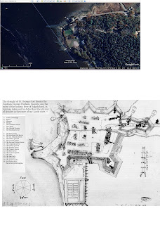
The model (below) shows no gabions (above),
and I think someone is showing the imagined "fortress walls" in the "draught" of the Fort,
the conjectured "first stone wall" often cited by a great number of authors.
“This model recreation, a gravel parking lot, and a large collection of artifacts are all that remain of an English colony established in 1607 in Phippsburg, Maine. The Popham Colony was the first organized attempt by the English to establish a colony on the shores of what we now know as New England. It was planted at the mouth of the Kennebec River in the summer of 1607 and lasted for little over a year until it was abandoned in the fall of 1608. To return home to England, the colonists constructed the first ship ever built in North America…"
Documents record that at Fort St. George the colonists built
a trenched fortification, a large storehouse, a chapel building, and a house
for Raleigh Gilbert. Shipwrights who accompanied the voyage constructed a small
vessel called a pinnace, which the colonists named the “Virginia” and sailed to
England on their return.
Scholars viewed the John Hunt Map with skepticism. President
George Popham sent to James I a report that the Native Americans say “there are
nutmegs, mace and cinnamon in these parts” and that just seven days away lies
“none other than the Southern Ocean, stretching towards the land of China:” the
fabled and sought-after northwest passage.
The Hunt Map, in the permanence of the fortifications it
shows, number of structures, elaborate gates, and especially its almost
whimsical embellishment, similarly strains credulity. John Hunt enlivened the
map with fiery blasts from the cannon, pennants flapping atop rather fantastic
crenelated gates, and a walled garden outside the ramparts. “A lot of us poo-poohed
the map,” says Pemaquid, Maine archaeologist Neill DePaoli, as “highly
exaggerated fiction, created trying to promote things back home.”
Still, the map had been taken seriously enough to inspire
1962 and 1964 Sabino Head excavations by Wendell S. Hadlock. He trenched
extensively, but found no foundations of stone. He did dig through evidence of
burning, and uncovered a few artifacts, notably North Devonshire sherds, but at
the time he could not date these with precision. Hadlock concluded that at best,
while the site might be Popham Colony, erosion and disturbances left little
remaining. Reviewing Hadlock’s notes, Brain felt the same results did not rule
out the presence of the colony. Hadlock could easily have missed Fort St.
George, expecting obvious foundations and using relatively crude methods.
Hadlock dug only the width and depth of a shovel blade, and failed to note such
basics as vertical position of the artifacts discovered.
Brain agreed that the map exaggerated. The colonists had 52
days to build before October 8, 1607, the date of the map; John Hunt must have
drawn structures from his imagination. But Brain’s walk told him the modified
star shape fit the land well. And hadn’t the colonists accomplished much? They
built a fortification with buildings (numbered by one source in Thayer [1892]
at “50 howses therein”), explored the Maine coast and interior, and built the
“Virginia.” To Brain, at the worst, the question posed was: How much of it is
real, how much, fancy?
https://www.athenapub.com/AR/10popham.htm
12/0/2024 - I had posted this link in error (interesting as it is): https://nature.berkeley.edu/departments/espm/env-hist/articles/73.pdf
"Though the Hunt map indicates the fort covered a footprint
of just one-half of a hectare (one and one-quarter acres) and an interior area
of one-third of a hectare (one- eighth acre), the impression it evokes is of an
extensive walled village with all of the necessary accouterments. According to
its date, the map illustrates the situation as of October 8th 1607, less than
two months after the colony's founding. The short time between the founding of
the colony and the drafting of the map has left many researchers incredulous.
It is commonly speculated that the map was partially a plan of what the
colonists intended to be build, rather than a record of what was already built.
It has been pointed out that the leaders would have desired to give their
backers in England the most optimistic reports possible, and that the Hunt map
would have played into that effort. The map also can be viewed as a stylized
illustration. 11-13
Prior to its settlement by the Popham Colonists, Hossketch
Point was occupied from time to time by local Wabanaki. After the colony was
abandoned, the Wabanaki made brief stays on the point once again. Apparently,
Europeans and their cultural descendants did not reoccupy the point until early
in the 1800s when a Mr Hill established his homestead.~' Through the nineteenth
century, several additional houses and farmsteads were built and maintained on
the point.
As of the end of excavations in 2002, evidence of the fortification trench and five buildings
that stood inside of the fort have been uncovered…Undoubtedly, a considerable
part of the construction was carried out by relatively unskilled laborers.
Indeed, some of the simpler forms of earthfast structures, such as those raised
on forked poles called cratchets, might have been built entirely by unskilled
laborers
20-21
In England, timber framing was a construction method most
commonly associated with the eastern and southeastern counties. Builders in
Western England were more likely to use cruck framing, when they built with frames
at all, or to build mass walls of stone or cob (mud).25
Fort St. George was not simply an English village, and the
culture reproduced there was not simply English domestic culture. Rather, Fort
St. George was one in a series of related English colonizing efforts. The
connections between these efforts suggest a simple mechanism by which the
experiences of each failed colony fed into a common pool of developing ideas
about how colonies should be organized, equipped, and manned. The growing body
of knowledge could easily have encompassed ideas about what kind of English
buildings would be most suitable in establishing new settlements.
Fort St. George was built and abandoned in less than 14
months. Faced with novel conditions, such as an abundance of timber, and new
kinds wood, the colonists may well have made innovations in the way they
approached the building. Essentially, however, the entire store of knowledge
that the colonists possessed came with them on Mary and John and Gift of God.
As Abbott Lowell Cummings wrote in his classic book The Framed Houses of
Massachwetts Bay, 1625-1 725:
The immediate background of this dominant [English] majority
among the earliest inhabitants is thus a matter of basic concern. The observer
must be able to recognize the evolutionary changes that occurred in
postmedieval vernacular buildings during the reigns of Queen Elizabeth and the
early Stuarts. He must know the exact level of development and the character of
these humbler English houses at the opening of the seventeenth century in terms
of plan, construction technology, and regional stylistic differences if he is
to understand fully the structures built by Englishmen in the New World
throughout the &st century of settlement. p26
Where many posts are to be set close to each other, as in a
palisade, a trench may be used in place of individual holes. Trenches are
conceptually similar to holes, and their fill will exhibit the same kind of
mixing as in postholes. Such trenches are a subset of a larger group of
features known to archaeologists generically as "builder's trenches"
or "construction trenches."
Conclusions Initial reports to England were promising: work
on the fort moved apace, relations with the native Wabnaki were cordial, and
according to the Wabnaki, all of the treasures that the English sought were to
be found within easy tra~el.~' By the end of the fist winter, however, the
outlook became more bleak. According to Ferdinando Gorges, the storehouse
burned along with much of its contents.92 Of the promised riches, only timber,
fish, and k s appeared forthcoming, and at this early date, these were not
enough to maintain the enthusiasm of the colonists. George Popham died and
Raleigh Gilbert replaced him as president. Reportedly, this led to a souring of
relations between the colonists and the neighboring News from England that both
John Popham, the colony's chief political backer and financier, and John
Gilbert, Raleigh Gilbert's elder brother, had died completed the dl fortune.
The colonists sailed away to England before a second winter could take hold,
and Gorges' remark above provides a concise epitaph.
But the colonists left their mark on the ground, albeit less
of one than they hoped.
When a shipload of Frenchmen visited the Sagadahoc in
October 1611, they easily found the abandoned fort. Impressed, they began
"praising and boasting" of the English enterprise, though, alas, they
did not itemize what they found..." page 94
voyages: https://archive.org/details/earlyenglishfren02burr/page/n9/mode/2up


