Thursday, November 01, 2012

Walking Into a Maya Village with Jan Brown

Above: On the Bridge above the mangroves with Jan Brown, the Marco Gonzalez Archaeological Reserve, the crown of the trees growing on the part presently above sea level at least, visible behind her. That "black dirt," the anthrosol, the humanly created and humanly placed soil, extends outward, under the mangroves that can tolerate living in the brackish water. The Island, Ambergris Caye - and only an island because the Maya cut a channel into the coral reef and across the penisula - "was home to an estimated 20,000 Maya traders at the height of their occupation of the island. There are 18 sites recognized on the 25 mile long island and none of these sites had been preserved. In 2008, a conversation between Ex-pat Jan Brown, living here for several years, and a prominent citizen, Winston (Frank) Panton took place regarding this. An idea was born. Jan proceeded to talk to officials about the selection of the Marco Gonzalez site to be preserved to become a visitation site. By April 2009, the announcement came forth - Marco Gonzalez Maya Site was to be the first official location to be preserved. Restoration of the site and a Visitors Center/Educational Center would be developed for all to enjoy ( http://ambergriscaye.com/marcogonzales/ )..."
You might wonder how many people presently live in Belize: "Belize currently has 220,000 people, 4000 on Ambergris Caye. At the high point of the Maya population, the whole of Belize including Ambergris Caye had 2,000,000 people," or so it is believed by the people (or person) who maintain(s) the Ambergris Caye Web-site, that includes the page I lifted this above information from: { http://ambergriscaye.com/pages/town/factsbze.html }
Below: First glimpses of the "Black Dirt (and the first of many termite nests)."
Imagine this: every foot step that anyone takes on this site, this National Park, is on something that was placed there sometime in the last 2,000 years. Well, almost everything. It has been washed over by the continually rising ocean, so flotsam has been added at the same time as the site has been eroding and people have been digging and looting. The more modern (and supposedly "more civilized") cultures of the last 500 have also, like the original Maya, have been planting food in the Black Dirt every now and again. I wondered now and again what trees might have been growing on the island before it was quickly de-forested, as was the rest of the Carribean, an unknown number of species probably clear cut into extinction that causes Conservators of Antique Furniture to scratch their heads as they stare at some sort of wood they can't identify... 
And then there's a tool someone left just laying around...
And then there are these sorts of artifacts that Jan pointed out to me:

It was a little chilling to have a human leg bone pointed out to me.
But then again, when Jan pointed out a piece of human arm bone, I told her I found it "Humerous."

Tuesday, October 23, 2012

Marco Gonzalez Maya Site Visit (The Entrance)

Waiting for Jan at Mata Rocks after the rain stopped

     I had called Jan Brown to set up a tour of the Maya Trading Village about 5 miles south of my hotel, and after putting it off a day or two due to some rain showers, we finally travelled down that bumpy and muddy road in her golf cart, just above the mangroves with their feet in the brackish water. I held on tight as we entered the last stretch of the road, where the town of San Pedro had just dumped some fresh (almost) crushed (almost) limestone in anticipation of a possible visit from Dr. Awe, the Director of the Belize Institute of Archaeology that might happen the next day or the day after  -or next week or next month, which is sort of the way everything seems to happen on Ambergris Caye off the coast of Belize, just south of the southern Mexican Border on the Atlantic Coast in Central America where the Caribbean Sea meets the second largest coral reef in the world (I think that about sums the location all up).
       Now, I've got to tell you that I've never been on the top of a Maya Temple - or an Adena Mound or turtle made out of shells in what is now known as Florida or anything like that - never even seen one in the distance. The closest I've ever been to anything like that is a pile of stones maybe ten or twelve feet high and thirty feet around, a mile or two from my house. And the heap o'stones is built on a hillside, so maybe it only seems that tall, and is that tall, if you stand in a certain spot and the wind is right (or something like that).
        My first view of the Marco Gonzalez Archaeological Reserve, a Belize National Park, reminded me of my own backyard where I've placed some old scrap boards around some stone mounds behind my chicken coop so that in case anyone ever does show up to look at them, they will know where to step. The building at Marco Gonzalez is however in much better shape than my old chicken coop...
   Now please understand, I am not poking fun at this Maya Site. My visits there were just about the most incredible experiences in my life. I'd trade a dozen visits to all the other places, where I'd walk a roped-in designated path to a designated photo opportunity spot to end up looking at labelled exhibits behind museum glass, for just one more visit to MGAR. I paid my entrance fee to Jacob, the 22 year old caretaker, and to the best of my knowledge, the only employee of the national Park, looking down at these artifacts on display on a piece of card stock I suspect was labelled by Jan - perhaps an earlier version on the other side: 
An Incredible Display of Stuff
There was other stuff on that painted plywood shelf below the window screens. I started to reach for something and then remembered my manners.
  "May I?" I asked.
Jan said, "Go right ahead!"
And I picked up what looked like a slate birdstone:
Swiss-Army Birdstone
Now that's just me, calling this a slate birdstone. Jan said something about it being an axe, possibly hafted on a shaft of wood, and I could see that beat up axe edge (and I remember thinking "hand axe") by my pinky finger but I couldn't help but notice the notch above my thumb in the above photo, and say like I say about stones I find at home, "This part could be used like a shaft abrader."
And then turn the stone and find another hand hold and another size abrader.
And then suggest that it might be sort of a Swiss-Army Bird.
And then get that "How many Grateful Dead shows has this guy been to?" sort of look from the person I'm suggesting such a suggestion to...
This one below, I am happy to say, I have no clue about. Is it bone or stone or fossilized wood, a tool of some sort or just a chunk of something used as landfill to create the site, the village?
I'm proud to say, "I don't know."

      Jan directed me to a shady spot where I guess she gives more graceful people an opportunity to sit and see some more amazing artifacts from the site, sort of a preview of what's to come, but I actually stepped where I shouldn't and knocked apart a bench or table or something that wasn't nailed down and was quickly directed toward another spot where the budget (that I suspect might come out of Jan's pocket or the occasional donation) had allowed the use of nails...
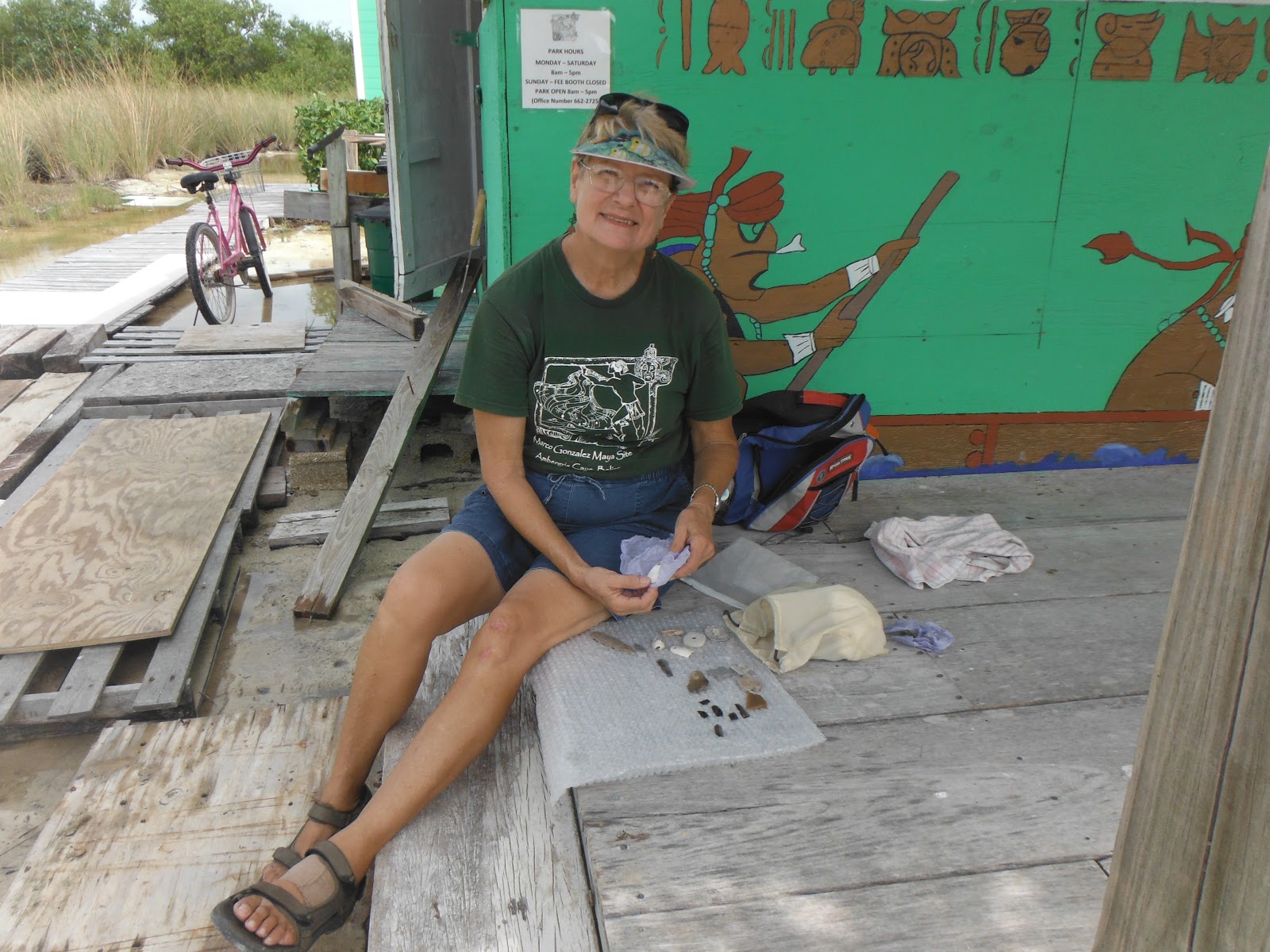
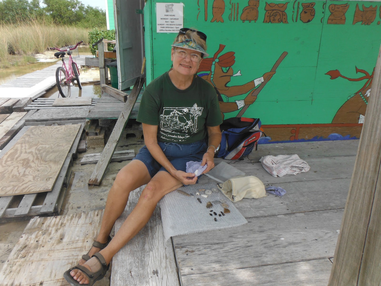
"Miss Jan" Brown

      Jan began unwrapping some items and placing them on some bubble wrap. Notice I said, "Some items." This called an 'Understatement,' I believe; she is actually displaying a random selection of incredible artifacts that may be anywhere from 500 years old to 2,000 years old, found on this human-made mound of Anthrosol (humanly created soil), layer after layer of which had been placed there by hand, probably basketful  by basketful (potful by potful).

There were pottery shards and stone tools...
Fossilized bone needles and fish teeth...

and Shell Jewelry.
And Obsidian!
Jan said some was green and some was almost clear,
depending on which volcano on the mainland that it was found near...
And I said "What? Green? I've never heard of Green Obsidian"
And she said hold it up to the light.
So I did:
And I tried another piece from a different place:

Ah, I could have spent alot more time looking at all and holding all these things that somewhere else (anywhere else) might've been behind glass (that might have a sign that warned you not to even touch the glass) but the trail began to call to us, the quarter mile hike across the mangroves, on a boardwalk just above sea level (mostly), so with a glance backward:
And a quick look at a sign post:
We started the walk to the Reserve:


Tuesday, October 16, 2012

Preface to "Marco Gonzalez Archaeological Reserve"

    Down on Ambergris Caye in Belize recently, my wife and I were faced with so many choices of just which Maya Ruins to visit. Actually it seemed as if there were too many choices and there it was on our "Things To Do in Belize" list. 
    We could go to Altun Ha, for instance, "the site where famous Jade Head of Kinich Ahau the Sun God was found. It consists of thirteen temples and two plazas. The most famous temple is the logo of Belikin Beer and is featured on the bottle. Flourishing during the Classic Period of Maya civilization, Altun Ha is located 30 miles north of Belize City and six miles from the Caribbean Sea."    
(Above photo stolen from ~ http://www.corozalbay.biz/altun.JPG 
Below is an original of mine.)


    We eventually decided that the Lamanai ("submerged crocodile") Tour sounded like a good deal. All we'd have to do is call up one of the many places that would set up a flight or boat trip to the mainland around sunrise, transfer us "to New River departure point in an air-conditioned vehicle.... board a boat for a 26 mile river ride to the site of the Lamanai Mayan Ruins," inticing further us with the prospect that we "might be able to spot crocodiles, Iguanas, exotic birds, manatees, bats and other wildlife during this boat ride." And then have a Free Lunch, "Belizean Rice & Beans, Stewed Chicken and Cole Slaw along with a refreshment," after which a "Licensed Tour Guide will take you (us) to explore the Lamanai Mayan Ruins, explain how the Maya lived here, climb the Maya Ruins, take a photo next to the huge stone mask, view the howler monkeys and explore the on site museum," and then eventually pack us back off to where we started, after sunset. 
(Stolen Lamanai images from the same source above)
    Since it was "the wrong season," as one or more of the locals let slip in conversation, we had been playing everything by ear, as they say, which meant keeping our weather eyes peeled, as they say. Often it looked like this from our room: 

    Young Greg from Ohio and I were up to witness just about every sunrise at the Resort, as if it would help us get our money's worth out of our vacations. He did the trip to Lamanai one day and, although the rain never let up for a single minute, he really enjoyed the experience. Young Greg is a single man and I have been married for 30 years. It did not take long for me to imagine how my wife would feel about having the same experience in the rain (for double the price Young Greg had shelled out). I began to think that the visit to the ruins on the mainland might not be a good idea. It was incredibly fortunate that my wife was very understanding about this (I suspected that this wasn't at the top of her list anyway) and that just 5 miles south of our hotel was an "undeveloped" Maya Site, a "gem in the rough" I'd read, which was really more "up my alley" than some typical tourist type of a tour. I couldn't think of any better way to see if there were some "Maya Connections" between this site and the sites that I've stumbled around here at home for the last twenty years - and the sites I have experienced vicariously with an ever widening circle of friends via the "Worldwide Internet."
     My mind was made up when a woman who appeared to be an "ex-patriot" having a morning coffee at the "palapa" (literally "shelter") barely visible through the rain in the photo above said a person "would have to be crazy to go there this time of year." 
    I do have a reputation to maintain, I thought...

Sunday, October 14, 2012

Back from Belize

after going here:
 on a tour with Jan Brown:

A seemingly familiar shape in a platform mound...

Monday, October 08, 2012

Rethinking Columbus:


 Towards a True People's History


"For years, I opened my 11th-grade U.S. history classes by asking students, “What’s the name of that guy they say discovered America?” A few students might object to the word “discover,” but they all knew the fellow I was talking about. “Christopher Columbus!” several called out in unison.
“Right. So who did he find when he came here?” I asked. Usually, a few students would say, “Indians,” but I asked them to be specific: “Which nationality? What are their names?”
Silence.
In more than 30 years of teaching U.S. history and guest-teaching in others’ classes, I’ve never had a single student say, “Taínos.” So I ask them to think about that fact. “How do we explain that? We all know the name of the man who came here from Europe, but none of us knows the name of the people who were here first—and there were hundreds of thousands, if not millions, of them. Why haven’t you heard of them?”

http://www.commondreams.org/view/2012/10/06

Thursday, September 27, 2012

On the Cliffside by the Ridgetop

Back in April 2012, I explored a little of this cliffside. If memory serves right, there's a little overhanging spot with a curious little slab of stone that might be intentionally set up the way it is and maybe enhanced as well:
I had this nagging little feeling that I'd seen something like this somewhere before.
Eventually I realised that it was reminding me of a photo I'd seen that Larry Harrop had taken, somewhere in Rhode Island, I believe:
This might just be a coincidence, but then again, maybe not not. Larry's photo is striking and dramatic, might give you goosebumps every time you look at it, and leave you filled with a sense of Mystery and Wonder. Mine is maybe just some rock that cleaved off an outcrop and just happened to stick into the little bit of soil below, but you never know. I flipped these images around, as if this would help me gain enlightenment, and still really don't know what to think...


Ridgetop

Boulder, perched on the bedrock, in Sept. 2012 
Looking to the right, there's some suggestion of stones stacked on the bedrock, as if the large almost level area of the ridgetop just above here might be encircled by stones - which turns out to be almost the case and cause for me to wonder about all sorts of possibilities. There isn't a solid unbroken ring of stones - are they now missing or was the encircling row being built and never finished? Were the gaps intentional and part of the whole deal? These are probably things I'll never be sure of unless I find that 3 or 4 hundred year old Pootatuck man that could tell me...
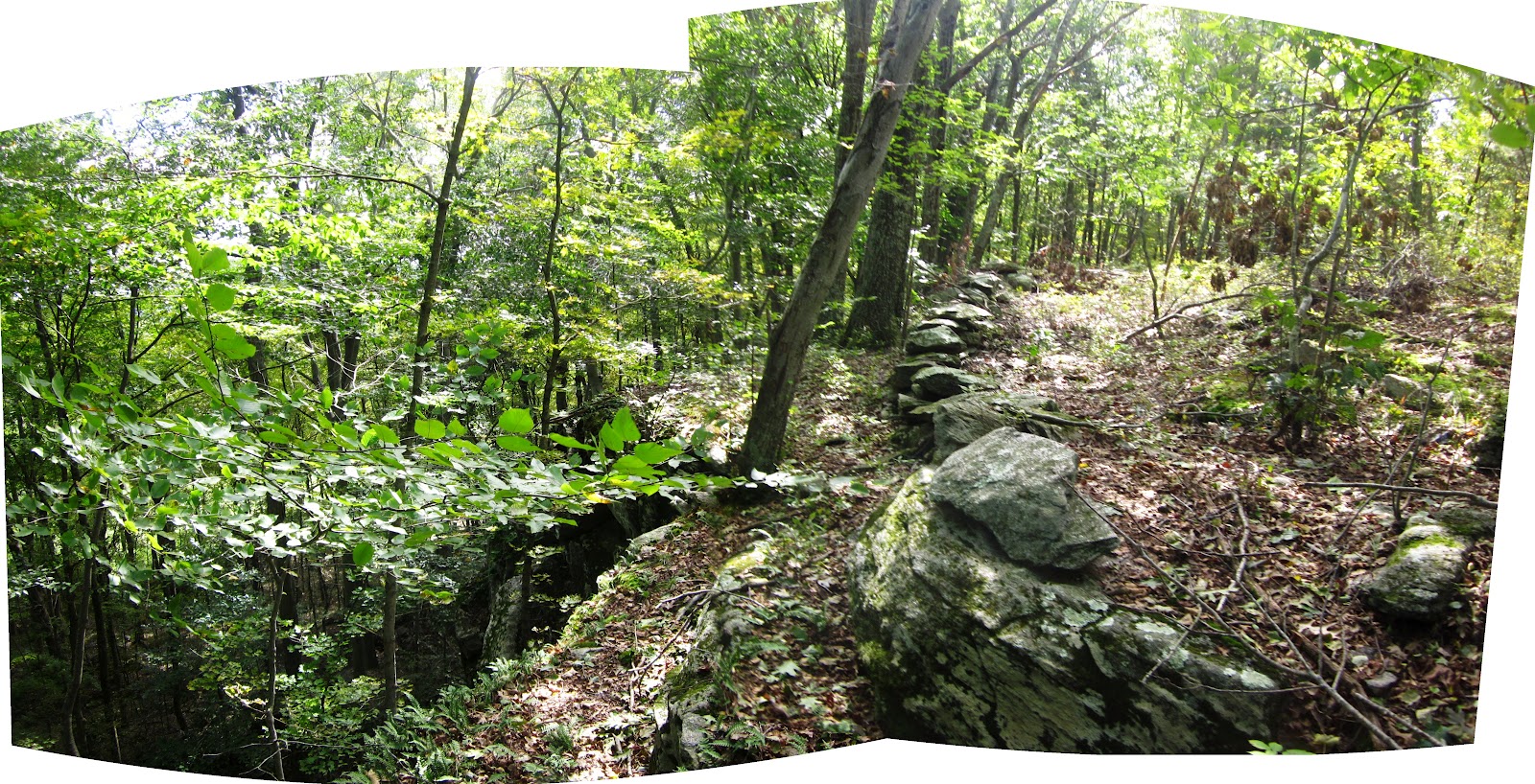
Another bunch of photos to open in a new window or tab, this photo was taken looking back toward the colorful boulder, which would be to the extreme left. There's a stretch of stone row toward the left in the photo above, boulders and cobbles that in a way is like a barrier that also makes a little walkway along a cliff side, on the cliff side of the stone row...


Above: outside looking in, below: inside looking out...
The three photos below are of some sort of possible effigy...
At its most northern point this row blends into the outcrop, you might say...
...and walking to its south it blends back in again (note the cobbles placed in the gap).

Then the row seems to dissappear - or something...  
...another walk along this eastern edge of the ridge is certainly something I intend to do.
I want to look at this "not too short stretch" of stone row again, as well as this one below that is orientated East and West - and how did I walk by that boulder without looking at it more closely???

This boulder hidden by the tree that my photo merge chose as a focal point, cropped from the original:

There are tangles of barberries and those invasive roses I can never remember the name of as you head to the southern border of this piece of land trust property, hiding more stone work. Some is zigzag and some is not, including that linear property line with its posts and wire...


...a little modern shrine (with a stone pile in front of it?)...

...and a wild life (or curious unintentional tresspasser) cam:
I smiled and waved, of course, and then waded back into the brush, following this low stone row that can't be seen all that well really, but eventually led to the "Short Stretches" from that first post:
http://wakinguponturtleisland.blogspot.com/2012/09/short-stretches-for-pw.html