The first stone walls I started to look at before the
last Archaeological Roundtable on Ceremonial Stone Landscapes in 2014 (on the
grounds of the “Toot” anyway – I pass miles and miles of walls as I take some back country shortcuts to get to the place)
were not so massive as that big enclosure in the last two previous posts. These
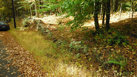
rows of stone near the entrance to the museum and parking lot (look carefully
and you will see the sign and lamppost) are not quite linear in nature and flow
with the topography – and could be said to resemble the body of a rattlesnake.
I looked at the stones on the side of the road
awhile, looking for signs of stones placed so as if to recall animals or
human-like heads, found a few:
Then took a walk “northish,”
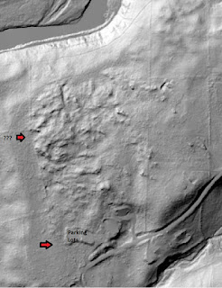
along the lower western border of the property - which turns out to be a Land Trust property:
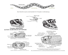
So, there by the lower red arrow, a segment of stones begins. It’s only with hindsight do I suddenly now see that the stacking method could sort of be the imitation of
rattlesnake scales (squamation or scalation):
Prompting me to paste an eye onto the image, under a long flat stone that resembles the supraocular scale
Looks like there were two photos I meant to merge, so here
you go:
I’ll
be durned if there isn’t a second neglected set – the row of stones that
branches off to the west: And a third:
I’ll end this
post for now, leaving you with some more from Rolf Cachat-Schilling in A
Quantitative Assessment of Stone Relics in a Western Massachusetts Town:
- Structures
are positioned in an area where their presence is impractical for known
post- Contact Euroamerican economic uses and their construction is
difficult.
- Structures
consist of stone types and shapes not evidenced in nearby Euroamerican
structures, or in historic-period overseas examples of European stone
works (esp. Scotland, Ireland, Brittany, Italy, Portugal).
- Structures
show labor intensity and extent of labor that is impractical and would be
inefficient/wasteful under pragmatic terms.
- Number
and elaboration of features are obstructive of co-use for grazing,
watering stock, etc.
- Frequency
of structures and similar sites defies practical explanation.
- Orientation
and nature/types of features do not translate to Euroamerican uses.
- Orientation
and nature/types of features translate to known Algonquian ritual uses
(direction of ritual significance, primary re- source orientations, unique
land feature orientation).*
- Features
fit known ritual practices of the Middle-Late Woodland-to-Contact Period.
- Terrain
on which features sit lacks evidence of Euroamerican use, documented or by
visible artifact (including vegetation types, tracks, debris, relics).*
- Neighboring
terrain is unsuited to Euroamerican uses.*
- Site
lacks evidence of Euroamerican structures.*
- Site
is consistent with recorded Algonquian CSL sites in terms of location and
content.*
- Structure
lacks evidence of recent tampering.
- Structure
is consistent with other structures on site.
- Structure
is consistent with structures in other sites in town.
- Structure
is consistent with known structures outside of town, but in the Eastern Algonquian
region.*
- Structure
is consistent with a documented written description, drawing, painting, or
photo of an Eastern Algonquian structure.*
- Structure
is consistent with a known structure that has received Federal or State
recognition as a Native American historic feature.
- Structure
is consistent with tribally recognized features.


No comments:
Post a Comment