Pages

Thursday, August 31, 2017

Estate Wall or a possible Qusukqaniyutôk? (Washington CT)

Or the first of a series of sketches before the 
12th Annual Native American-Archaeology Roundtable 
“Our Hidden Landscapes: Native American Stone Ceremonial Sites in the North American East"
to be held on:
Saturday, October 28, 2017
at
The Institute for American Indian Studies (IAIS)
38 Curtis Road
Washington, Connecticut  06793
(860) 868-0518

     You could say it’s a “massive stone wall,” large and heavy or solid, as in "a massive rampart of stone," “impressively large” as both Miriam and Webster put it when compared to the other rows of stones that are found on and around the grounds of the Institute for American Indian Studies in Washington CT, but that’s the word that comes to mind for me when looking at the Stone Structure to the right of the driveway leading to the Research Building where the 12th Annual Native American-Archaeology Roundtable will be held on Saturday, October 28, 2017. The event is being called “Our Hidden Landscapes: Native American Stone Ceremonial Sites in the North American East" but the “wall” is hardly hidden, showing up on the Google Earth image below.
   Drawing a line for a path, I was just a little surprised to find the segment is about a quarter mile long – 404 meters or 1,327 feet, about 442 yards long if I trust the dialogue box that pops up when I use that feature.
   I wrote a little bit about this “stone wall” a few years back, noting that there were apparently capstones on top of this structure, http://wakinguponturtleisland.blogspot.com/2014/11/capstones-defined-sort-of.html, but as the little sketch shows (I hope) there’s turtle imagery or iconography to be seen in some of the more intact “capstones.”


  What really changed my mind about this seeming “Estate Wall” was a gateway that, at least to me, seems to recall other Great Serpent Gateways, as I call them.
(Note the stone heaps above)
(Closer view with life-sized human dummy for scale)

(Enhanced and labelled  LiDar View)
   Take into consideration as well the adjoining rows that form a rectangular area enclosed by similar massive “walls,” and you may begin to think of this wall as a possible qusukqaniyutôk or ‘stone row, enclosure’ as Doug Harris and Paul A. Robinson put it in “Ancient Ceremonial Landscape and King Philip’s War” (Northeast Anthropology  2015:140). Please note that Harris and Robinson will be speaking at this Roundtable event – and that I haven’t actually read what they wrote but did see that Rolf Cachat-Schilling makes reference to the work in “A Quantitative Assessment of Stone Relics in a Western Massachusetts Town” (2016 Massachusetts Archaeological Society) which you can find here:


Elaine Thomas (Mohegan) will also be speaking at the event and I have to remember to ask her about this photo and the similarities of these stone structures with those "Toot Stones."
 (To be continued...)

Wednesday, August 30, 2017

Spirit Eyes


       “Severed Hand is a ceremonial way; a place our ancestors went to "train" and study medicine. Here, within the rock pile’s niches, stones are often arranged for filtering sunlight to shine through and to give the impression that glowing eyes are watching you.  This, I have seen many times and is considered ceremonial to represent the “Spirit of Place;” a glyph in itself which reminds us “the Spirit of Place” is always watching.  

        You may not see (the) spirit but (the) spirit sees you..."
  
 Photos Courtesy of Alyssa Adisi Waya Alexandria; The Running Wolf Collection


Blog entry for August 14, 2017 here: 

Tuesday, August 08, 2017

Pocumtuck Homelands Festival 2017

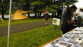
   The 4th Annual Pocumtuck Homelands Festival was, in a single word, “Nice.” It was nice to be invited, nice to be in a place where Ceremonial Stone Landscape features are recognized and well known. Everyone I talked to was so very nice and almost everyone had a story or two (or ten) to tell about interesting and intriguing stones as I stood at a table with what looked much like somebody’s 6th Grade Science Fair Project.


   And it was especially nice to meet Diane Dix - who I thought had a little twinkle of mischief in her eye as she directed some very nice people to move my designated spot under a tree to a more prominent place by the paved path, right beside the table set up for the Mashantucket Pequot Museum and Research Center. It was nice to see Kevin McBride and talk just a little although I have to admit that I sort of didn’t recognize him right off since my mental images of both of us have much darker colored hair. I had the flyer for Doug Harris’ talk in Northampton the same day on the corner of my table and I recalled seeing a photo of him standing by that Killingworth CT stone turtle mound featured on the flyer. He told me it seemed just about impossible that anyone could look at it and not think “Turtle!”

   And it was nice talking with my other neighbor, Hawk Henries, finding we had a mutual friend who lives near him in Maine. Hawk makes beautiful flutes, so of course we also talked about music – and I even got to say to him, “I also have a Digeri-doo but when I play it people say Digeri-don’t, man.”


My neighbor Liz Charlebois across the path showed me some magic. She folded up a single layer of birch bark (like you would a piece of paper for a snowflake), put it in her mouth and bit it (sort of like flattening a porcupine quill but not), unfolded it and revealed a design much like the others she had on display.
   Eventually I did get to wander to other booths and tables, recognizing at one Mr. Evan Pritchard. We talked a while about stone turtles and more, even adding some details about the area where I live to some maps he has been working on.

  Even though the sky would turn the nicest shade of blue one minute, sunlight dancing on the River, the next minute the big white clouds would turn dark and the rain would shimmer and sparkle in the air in much the same way, dancing in the light of a sun shower.


  Late in the day, while Hawk Henries took the stage for a second time (all the music was good, a nice soundtrack for the Festival), a rainbow appeared in the east, seemingly touching where river met land, and as if on cue, a bald eagle flew for a time under it...


Thanks again to Diane and everyone involved - especially Joe, Bernard, Anne,Pam, Alma and everyone else who spent some time talking with me!!!
Be sure to visit the Nolumbeka Project website!


Friday, August 04, 2017

Schaghticoke Mountain Firescape

   I was just wondering how the burnt over landscape looks above Schaghticoke.

   Are there Ceremonial Stone Landscape Features now more visible after the fires have passed over, like those places out west that I’ve read a little about, like in Montana or Wyoming?

    I look at the map and wonder...
...just as I've wondered before:

   "By burning the 600-acre stretch of grassland in northeastern Montana named after one-time landowner Henry SmithChase gained perspective that would have been nearly impossible to achieve with traditional archaeological techniques. A research aircraft later flew over to image the freshly exposed artifacts, including the remains of rock structures used to corral and kill bison, stone vision quest structures where people fasted and prayed and stones arranged in human and animal shapes.
“Before the fire, if we were looking at the site through a door, we were just looking through the peephole,” says Chase. “Now that we’ve burned it and recorded it, we’ve opened the door so we can see everything there.”
As far as Chase knows, it’s the first time an archaeologist has intentionally set a cultural site ablaze. It’s much more common for archaeologists in the Western U.S. to worry about wildfires--or fire-fighting efforts--damaging a site. But since grasslands are adapted to natural fire cycles, Chase had a rare opportunity to use fire as an archaeological tool. It's a tool that has had surprisingly successful results thus far. Chase is still analyzing the flight data from this year’s 400-acre burn, but an initial burn last spring revealed 2,400 new stone features – about one every three to five feet..."