One of the things
about identifying Indigenous Stone Features is the “purposeful placement” of stones, whether
it’s a tiny turtle (or bear or bird or a rhomboidal quartz stone) placed on a
mound or a boulder or a row of stones or a large combination of boulders/stones
that creates what people often call a “calendar.”
All over the
world, our human family has created these sort of things in the past and
because it marks a certain solar event on a certain date we assume that that is
what the creators were doing so we call Stonehenge a giant calendar and we assume
that some big celebration took place on that event – and people will dress up
(or get either naked or semi-naked) and flock to some of these places and have some sort of
pagan party:
(“Pagan Writer” –
and former head of the American Nazi Party - Francis Joseph "Frank"
Collin is probably washing his white robes right now so he can show up at some
place or other in the mid-west, maybe the Great Serpent Mound or Cahokia, reminding
us all that it was some white Aryan Tribe that anciently sailed to what is now
called “America” to smarten up the savages and bring them a higher degree of
civilization, thanks to this Master Race. It’s a good thing that the man has
reformed his evil ways and is no longer spewing hateful bigoted propaganda
built on misconceptions. Google him if you choose to get totally depressed knowing the man is well funded unlike legitimate researchers focused on empirical evidence, sadly proving the "real money" is in pseudoscience - and that there really is a sucker - or seeker - born every minute…)
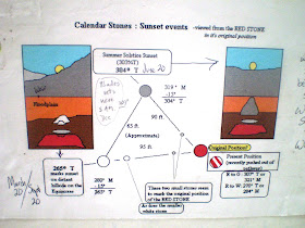
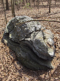
I know of one
place that is a definite “triangle of stones,” three large boulders and some other
smaller stones as well, which is good because the “viewing stone” has been
moved from its original placement, knocked out of place by someone I know who
used to mow the trails used by a Fox Hunt Club. Some barely visible smaller
stones possibly form a line of stones along the sight line to a boulder that marks
the Equinox sunset as well as to another standing stone sort of boulder that
marks the Summer Solstice or “Solar Stand Still.” I’ve seen the Spring Equinox
sunset occur over the Equinox Stone(s), but never the Summer Solstice. “No one
is taking care of the place,” as a 500 year old elder who might have one time
lived in the area might say, so trees block the view of the Summer and Autumn
sunsets.
And I wonder what
that 500 year old Elder would say about the calendar sort of function – would he
or she say, yes this marks the time of this and that? Or would the Elder tell
me all the other hundreds of “signs” for proper times to perhaps plant corn or
fish for a certain fish heading up (or downstream) such as the size of the oak
leaves or the blooming of the shadbush trees (or the dark of the Eel Moon)??
Some people expand
on the stone markers, draw lines from them out across the big blue world, connect
them to other places and cite the significance of such a link, sometimes even
to Stonehenge if I recall correctly, but I tend to think a little differently about
this. Would the Elder tell me about places these stones point to?
Or would the
Elder instead point me in the other direction, standing there in the Heart of
the Village (as Burial Grounds are sometimes called), toward the circle of my
heart as I stand inside that triangular stone device centered in the circle of
the universe?? The Heart of the Universe??
I can answer that
one easily: “I don’t know.”
Now this was all
prompted by a Rock Pile post or two:
and you will note that in the comments of that second link I
asked if there were another stone (or more) involved in setting up the
triangulation that contributes to that purposeful placement of stones since you
can walk around any old stone and line yourself up with a sunrise or sunset
over the stone (or other feature of your choosing). I had asked that same
question this past September about the Autumn Equinox up on Patch Hill in Boxborough
MA :
Photo from reader Russ M: https://blogger.googleusercontent.com/img/b/R29vZ2xl/AVvXsEhZX1i6-OWG45q6FhLo3tyRM_Q1TyqNJO5jHQhzq9YaP3vQHqm4RXxCgmgi8xheOCq18rMT6f3BFrc57gB0sEwGPi069weSxZRkgOUFTZQbT8hVTGa2EoZANQW7u3b-YXkgHT48FA/s1600/EQstone+047.jpg
I still don’t know,
but I sure do know that there’s a great deal of suspected Indigenous Stone
Landscape Features up there on Patch Hill. I wouldn’t be telling the truth if I
told you I remembered this one especially; it seems that lately the only thing
shorter than my short term memory is my short term memory, but there’s a
species specific very realistic musk or stink-pot turtle stone up there:
There's also a possible mortar boulder, the “pestle” stone(s) still
sitting in place maybe:
And all the other things you can find looking through the
Patch Hill posts at Rock Piles, including the many comments some of them
generated: http://rockpiles.blogspot.com/search?q=patch+hill
And having recently made the acquaintance of Glen Mellin and
Lenny Truitt, a husband and wife team of Ethnoecological Researchers (who it
turns out are independently funding themselves, sort of in the same kayak with
no paddle as many Rock Piles independent researchers find themselves up the creek in), I
noted right away this statement in the Town of Boxborough’s web-page about
Patch Hill:
“Patch Hill Conservation Area is the largest conservation
parcel owned by the Town of Boxborough. Patch Hill Conservation Area also
likely ranks highest for wildlife habitat and overall bio-diversity, supporting
numerous vernal pools, rare species, several types of forest community, and
protecting the headwaters of Guggins Brook. Patch Hill itself, also known as
Goat Hill, is a glacial drumlin, the summit of which is either the second or
third highest point in Boxborough, depending on the source of information
consulted.”


No comments:
Post a Comment