Graphic by Steve Raggie, Waterbury Republican-American 1955 USGS above it with the town-line shown.
And I’ll throw in this 1920 photo from the Watertown
Historic Society, looking up at the hills where this site is located. I’m
trying to decide if I can identify the right one, an orchard and a meadow
perhaps, a woodlot above it. I think it might be about in the center of the
photo:
I walked in on Tuesday, just ahead of a winter storm,
wishing I had done so a day earlier when it was 20 degrees warmer, at the
proposed new road that would lead into the proposed development. It might be
that the old property line that created the eastern border of the Georgetown
Dr. Development property appears on the 1934 aerial photo below as a zigzag “fence”
along a former orchard, and I’ve put some approximate green lines in there that
probably aren’t exact in there. The town line dashed black line on the topo is
most likely the eastern border of the development. There’s a blue line of a
small stream and a brown line of a still existing segment of a very substantial
stone row in front of a brown house that will appear later on in this post.
There’s also some compromised boulder constructions that are along Bunker Hill
Road.
Above: recent brush piles, probably some recent stones
dumped on possibly much older stone piles. It’s a human tendency to dump stuff
on already existing piles – the Alice’s Restaurant theory of adding to a pile
rather than moving the old one because it the easy thing to do. My Chicken Yard
Mounds are a good example of this {http://wakinguponturtleisland.blogspot.com/search?q=chicken+yard}. Below: two views of another pile:
A Boulder by the row:
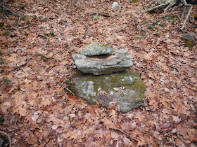
I wandered to the east and north a bit until this "large cobble stack” caught my attention. It’s at
a seep and that might be what’s left of some stone work around this little
spring. That rock formation above it is probably that elevation shown just to
the right of the town line on the topo map:
Some more views:
Note the flat
“metate-like” stone (I couldn't brush away the frozen leaves):
Just a little north
of this stack, I noticed some barely visible row of large cobbles/small
boulders:
And another nearby
stack and a boulder with a bowl-like depression in it:
– and a possible masher stone that matches up pretty
well with that bowl, now that I think of it, placed in turtle head position in
front of the boulder, much like this photograph from Dr. Luci Lavin’s new book:
The stack close up:
And the stack in
Turtle Vision:
Another stack?
Another Turtle?
To be continued, moving out of Watertown and the Green Zone, as a zigzag stone row remnant became barely visible...
..and back into the Green where it continues:


No comments:
Post a Comment