Pages

Tuesday, September 29, 2009

Assorted Snakes/End Stones


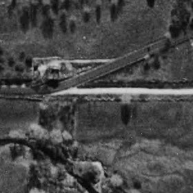
In the Screen Capture above, there's what might be a Serpent Stone Row at the left, by where the road and state highway meet. At the lower center, is the stone fish weir that gives this area of land - and the road and everything else - it's Native American Place Name.
Why this area of town is not an Historic District or why the Weir is not on the Historic Register is a Great Mystery.


The photo below was used in a letter, where I wrote about: "A Wall of No Great Importance."

"I attended a town meeting on July 7, 2005 regarding the realignment of Nonnewaug Road in Woodbury CT. Part of the proposed work involves the removal of a portion of a “stone wall.” A letter from the CT State Historic Preservation Office was read that stated that the wall is considered to be of no great importance, but I strongly disagree with that. The possibility exists that this row of stones may not be of Colonial or Historic origin but could rather be prehistoric in origin, built by Native Americans as part of a land management scheme that depicts a higher degree of civilization than is accepted by most archaeologists and anthropologists.
There are actually two adjoining stone rows in question. One is a linear row that joins a zigzag stone row, a row atypical of the incidental construction of zigzag row that results from stones being thrown up against a wooden “snake fence” that has long since deteriorated, as in described in books about stone walls by Eric Sloane and others.

Another straight-line row connects to this zigzag row along the road, the first terrace above the floodplain, the shores of a glacial lake…"


It's a little ironic that I wrote about a 'snake fence," since I now wonder of the linear row might be a Native American built representation of a snake or serpent...


Earlier this year, I posted something called: End Stones and also: More End Stones. Possibly I was going to continue some more about them because I found a folder labelled "End Stone" in 'my pictures,' yet another called 'endstone02.'
Imagine my surprise; I'd forgotten all about them.
I was going to start doing that all over again, only to find I'd already done so.
So please excuse me, "show and telling" the same old story, especially since I ranted and raved about its (partial) destruction ( A Wall of No Great Importance , July 2005, Linear row views, The Road Realignment, Wishing and Wondering, and probably more), but here and now I'm begining to think that this row that might just be a serpent row, once connected to zigzag rows, parts of which are buried or bulldozed away today. The end that connects to an ancient glacial lakeshore still remains down at the 100 year floodplain limit...


Above and Below: Looking north along the ancient lakeshore...


Bing maps still show how the road looked before the re-alignment:

(my address included in case you want to send me a Christmas Card or locate the spot yourself)
In this 1934 aerial photo, the zigzags show well...


The linear row shows well on this 1964 photo:


This drawing perhaps puts into focus the above aerial photos:


You also get to see the locations of some other stuff I wrote about, like the turtles in the chicken yard and the big box turtle by the stone row borders of the mast forest circa 1700...

Looking down at the remains of the Stone Serpent Row this past spring...

Snakes, "End Stones," and Some Re-thinking

There's been a recent exchange of Serpent/Snake photos, as well as a post of comparison photos (Serpent Mounds of Stone), that I've really enjoyed and lifted these first 3 photos from - and I think is yet another step toward these Rock Piles becoming an accepted part of the view of "Turtle Island."
It's yet another pattern, repeated in yet another place, that forms increases the probability that this is a "thing," as they say in the scientific community, I believe (similar to "scientific fact.").
So I began a little re-thinking process that started with a row (that I've walked alongside since the early 1970's!) that I've come to think of as 'the backbone' and all these other rows that terminate with what I've come to think of as "end stones."
I'm starting to wonder, "Could these stone rows be representations of snakes?"
Backbone:
This is the 'end stone' of the 'backbone.' It's a black dot on the 1934 picture below, the backbone illustrated in red leading up to a rockshelter.
From perhaps an eighth of a mile away:

The rockshelter at the Tail End:

Here's the "another one:"

This is a really abused and damaged row near a popular spot for picnics, parties, and recreation for a couple hundred years. There have been numerous fireplaces built and removed, countless rocks no doubt taken to the edge of the waterfall that the row points to and tossed into the pool of water below - a lesser of two evils I suppose when you think of how many glass bottles have been tossed to cut the bare feet of countless generations of waders, past, present, and future.

There are similar rows and end stones that all also point to the same river on the opposite bank, above and below these falls, the latter at another waterfall:

(these photos appeared at: Stone Rows and Other Features)

Way, way up the branch of the river that flows over the Falls, I photographed yet another end stone and posted it at: More End Stones in April '09:
Now here's one that finally more closely resembles all those other serpents from Pete and Larry and Mike. Way, way up the river, more than a little more remote and out of the human influence such as the impulse to knock it apart and haul it away to build something or toss in the water to make a big splash etc.
Although it might be handy to make a property line, like many have become. And, now that I think of it, I remember that I got to this spot one day, following stone rows that led me out of where I was taking photos In the Mound Swamp, where Norman once suggested another snake, this one zigzag and best illustrated in the drawing below, the snakes head marked as the "end stone:"

Sunday, September 27, 2009

Serpent in MA


From Mike Hoye

Sturbridge, MA

NEARA member

Saturday, September 26, 2009

Searching for the Serpent

(http://larryharrop.com/blog/images/Usquepaug/P1090406.JPG)

I'll tell you right up front: I got pleasantly lost looking for the above "Serpent in Usquepaug, RI" while sitting in my computer chair again this morning.
And I'll tell you again, like a demented parrot repeating "Bing Maps" and "Bird's Eye View," that I kept changing the view to get a look at the stone rows that sometimes stand out best using a southerly view.

I never found it, but I really found the stone rows intriguing.


Like this one near Bailey Pond in particular:


These below might be dismissed as a "cowpath," but as I switch view points, I think I see more than two rows, maybe some "stone heaps," possible effigies, inside the "cowpath," like some similar places I've been around here, where I can't convince myself that a farmer made a cowpath with turtles in the middle of it for the cows to admire on their way to dead end the double row turns into at the big outcrop overlooking a spring or other water feature that's also bordered with stone:


Note: There are snake-like stone rows near where I am in western CT, but they don't always show well. This (abused by ATV riders) snake row doesn't really show up at all:


I just deleted what I thought was an image of it when I realized I was totally wrong...

Friday, September 25, 2009

Computer Chair Travel

JimP's recent post about Westerly (Westerly Sun - Discovery of Indian remains ends ho... ) got me thinking about some stone rows and stone piles that I'd stumbled upon in Rhode Island (I first read Manitou while camping in Burlingame State Park). So I made use of the bing maps "bird's eye view" feature; sometimes you get lucky and can find a row you know as you change the angle from north to south to east to west.
Sometimes it works out, sometimes it doesn't.
Fort Ninigret above was easy.
I couldn't find a spiral row I'd come across (in 1991) in Burlingame, but here's an example of stone rows in the park:


I did find a Turtle I'd canoed to:


I remember trying to figure out how to tresspass into this "Deer Run Road" area because I thought perhaps there might be a stone row deer run deal, sort of like the same technology as a fish weir made of stone but for deer instead of fish, perhaps fire instead of water.
I never did it on the ground but did capture an image this morning that just might suggest such a thing...

Tuesday, September 22, 2009

Could it be Yet Another Uktena?


Failing to find a photo of the ridge that is said to be Unktehi, I came across "Fossil legends of the first Americans" by Adrienne Mayor in Google books, searching the phrase " Unktehi's bones."

Mayor writes: "Near Fort Snelling above the Minnesota River, the Indians pointed out a mound said to contain Unktehi bones...(Page 234)"

The page before alludes to the "diety" being able to manifest itself as a buffalo, while the next few pages suggest that the bones are those of mastadons.

So maybe my post: Could it be a Mastadon? could just as well be titled "Could it be Yet Another Uktena?"

Two Stories of Unktehi told by Lame Deer


"This story was told to me by a Santee grandmother.

A long time ago, a really long time when the world was still freshly made, Unktehi the water monster fought the people and caused a great flood. Perhaps the Great Spirit, Wakan Tanka, was angry with us for some reason. Maybe he let Unktehi win out because he wanted to make a better kind of human being. Well, the waters got higher and higher. Finally everything was flooded except the hill next to the place where the sacred red pipestone quarry lies today. The people climbed up there to save themselves, but it was no use. The water swept over that hill. Waves tumbled the rocks and pinnacles, smashing them down on the people. Everyone was killed, and all the blood jelled, making one big pool. The blood turned to pipestone and created the pipestone quarry, the grave of those ancient ones. That's why the pipe, made of that red rock, is so sacred to us. Its red bowl is the flesh and blood of our ancestors, its stem is the backbone of those people long dead, the smoke rising from it is their breath. I tell you, that pipe, that *chanunpa*, comes alive when used in a ceremony; you can feel power flowing from it.
Unktehi, the big water monster, was also turned to stone. Maybe Tunkshila, the Grandfather Spirit, punished her for making the flood. Her bones are in the Badlands now. Her back forms a long high ridge, and you can see her vertebrae sticking out in a great row of red and yellow rocks. I have seen them. It scared me when I was on that ridge, for I felt Unktehi. She was moving beneath me, wanting to topple me... It is I, Lame Deer, who said this..."
Told by Lame Deer in Winner, South Dakota, in 1969.
http://www.firstpeople.us/FP-Html-Legends/HowTheLakotaSiouxCameToBeBrule-Lakota.html
"When I was young, hardly more than a boy, I went after some horses which had somehow got lost. Following their tracks into the Badlands, I searched for many hours. I lost all sense of time and was surprised by nightfall, sudden and pitch-black. The clouds that were covering the moon and stars split open in a thunderstorm. Hailstones as big as mothballs blanketed the ground with icy mush, and I thought that I might freeze to death in the summer. I happened to be in a narrow gulch, where I was in danger of drowning from the rush of water. As best I could, I began scrambling up toward a high ridge. I couldn't see except when there was a flash of lightning, and the earth was crumbling under me. Somehow I made it. The thunder never stopped, and the lightening became almost continuous. I could smell the wakangeli, the electricity, all around; it made my hair stand up. The thunder was deafening. I straddled the ridge as if I were riding a horse. I could see enough in the lightning to know that I was very high up and the canyon was a long way down, and I was afraid of being blown off the ridge and hurled into that black nothingness. My teeth chattering, my legs and hands clamped to the razorback ridge, I moved inch by inch as I tried to get out of there. But I felt the presence of the Wakinyan, heard them talking to me through the thunder: "Don't be afraid! Hold on! You'll be alright." At last the storm ended, and finally dawn came. Then I saw that I was straddling a long row of petrified bones, the biggest I had ever seen. I had been moving along the spine of the Great Unktehi. Stiff with cold, I waited until the sun warmed me. Then I scrambled down and ran toward home. I forgot all about the horses; I never found them.

And I searched many times for the ridge deep inside the Badlands that formed Unktehi's spine. I wanted to show it to my friends, but I never found the ridge either."

* Told by Lame Deer in 1969 in Winner, Rosebud Indian Reservation, South Dakota
http://pyramidmesa.netfirms.com/brulesioux16.html

Monday, September 21, 2009

Turtle petroforms/petroglyphs


Above: Random Turtle Petroglyphs from a Google search, the first will interesting zigzags, the second with horns, the third a shield from: http://www.blm.gov/wy/st/en/field_offices/Lander/cultural/castlegardens.html...

Turtle petroform (resembling some from the Northeast) that I hadn't seen before from Bannock Point in Manitoba Canada:

Many more of various sorts at http://www.manitobaphotos.com/petroforms.htm, including a "woman form," much like those Peter been observant and imaginative enough to interpert and document...
Plus this one from the site: http://www.theturtlelodge.org/sacredSite.html

Thursday, September 10, 2009

Some "Lost" 2007 Photos


I'm guessing that sometime in late spring or early summer of 2007, just before I got my new camera that recently stopped working for no apparent reason, I took these photos of a serpentine stone row from the roadside in Watertown CT...


The story of how zigzag stone fences (attributed to European settlers) came into being is often repeated here and there, and is used by experts to explain away any possibility that Native Americans might have built them, but what about serpentine stone fences or rows?
And here's some 1934 aerial photography...